|
|||||||||||
| District HERFORD - Locations Register - |
|||||||||||
|
|
|
||||||||||
| District HERFORD on the map of Germany (Source: Wikipedia) |
District HERFORD on the map of North Rhine-Westphalia (Source: Wikipedia) |
|||||||||||
|
||||||||||||
|
||||||||||||
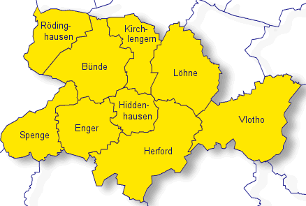
| Locations in the District HERFORD (Source: Wikipedia) |
||||||||||||


| The following Ortsregister contains all places of the "Geschichtlichen Orts-Verzeichnisses" (GOV) of CompGen in HERFORD. By activating the individual buttons in the four columns >Topo<, >SLUB<, >GOV< and >Meyers<, the geographical location of a place can be called up on a map from the geographical OpenTopoMap and Kartenforum or the place descriptions in the GOV-Ortsverzeichnis and Meyers Gazetteer. | ||||||||||||||||||||||||||
| A | B | C | D | E | F | G | H | I | J | K | L | M | N | O | P | Q | R | S | T | U | V | W | X | Y | Z | |
| Location | Distict | Location Typ | Coordinates | Topo | SLUB | GOV | Meyers | Community affiliation |
| Ahle | Herford | City Subdistrict | 52.1800 N 008.5200 E |  |
 |
 |
 |
B�nde |
| Ahleholsen | Herford | District | 52.2000 N 008.5000 E | |
|
|
|
B�nde |
| Ahlerbruch | Herford | District | 52.2000 N 008.4800 E | |
|
|
|
B�nde |
| Alte Siedlung | Herford | Place | 52.2010 N 008.4790 E | |
|
|
|
R�dinghausen |
| Altenh�ffen | Herford | Farms | 52.2370 N 008.5640 E | |
|
|
|
B�nde |
| Altevogt | Herford | District | 52.1565 N 008.5386 E | |
|
|
|
Enger |
| Arnholz | Herford | District | 52.1547 N 008.7650 E | |
|
|
|
Vlotho |
| Arode | Herford | District | 52.1200 N 008.6200 E | |
|
|
|
Hiddenhausen |
| Auf den Wittk�mpen | Herford | District | 52.1800 N 008.5800 E | |
|
|
|
B�nde |
| Location | Distict | Location Typ | Coordinates | Topo | SLUB | GOV | Meyers | Community affiliation |
| Bad Radringhausen | Herford | District | 52.2300 N 008.6000 E | |
|
|
|
B�nde |
| Bad Seebruch | Herford | District | 52.1350 N 008.8584 E | |
|
|
|
Vlotho |
| Bad Senkelteich | Herford | District | 52.1334 N 008.8754 E | |
|
|
|
Vlotho |
| Bahnhof | Herford | District | 52.2300 N 008.5200 E | |
|
|
|
R�dinghausen |
| Bard�ttingdorf | Herford | District | 52.1200 N 008.4300 E | |
|
|
|
Spenge |
| Barrenbruch | Herford | District | 52.1800 N 008.6000 E | |
|
|
|
B�nde |
| Belke | Herford | District | 52.1300 N 008.5700 E | |
|
|
|
Enger |
| Belker Heide | Herford | Residential Area | 52.1485 N 008.5820 E | |
|
|
|
Enger |
| Belke-Steinbeck | Herford | City Subdistrict | 52.1537 N 008.5678 E | |
|
|
|
Enger |
| Berg | Herford | District | 52.1500 N 008.6300 E | |
|
|
|
Hiddenhausen |
| Berge | Herford | District | 52.2500 N 008.4700 E | |
|
|
|
R�dinghausen |
| Bermbeck | Herford | District | 52.1580 N 008.6700 E | |
|
|
|
Hiddenhausen |
| Besebruch | Herford | Locality | 52.2237 N 008.7309 E | |
|
|
|
L�hne |
| Besenkamp | Herford | City Subdistrict | 52.1500 N 008.5700 E | |
|
|
|
Enger |
| Bexten | Herford | District | 52.1200 N 008.5800 E | |
|
|
|
Enger |
| Bexterh�fe | Herford | Farms | 52.1000 N 008.6200 E | |
|
|
|
Herford |
| Bieren | Herford | District | 52.2300 N 008.5200 E | |
|
|
|
R�dinghausen |
| Bischofshagen | Herford | District | 52.1700 N 008.7200 E | |
|
|
|
L�hne |
| Blanken | Herford | Hamlet | 52.2000 N 008.5700 E | |
|
|
|
B�nde |
| Blomeier | Herford | Farmstead | 52.1444 N 008.4665 E | |
|
|
|
Spenge |
| B�ckel | Herford | Estate | 52.2243 N 008.5186 E | |
|
|
|
R�dinghausen |
| Bockhorst | Herford | Residential Area | 52.1203 N 008.4716 E | |
|
|
|
Spenge |
| B�kel, Lippinghausen | Herford | Residential Area | 52.1498 N 008.6363 E | |
|
|
|
Hiddenhausen |
| Bonneberg | Herford | District | 52.1612 N 008.8267 E | |
|
|
|
Vlotho |
| Borrenkamp | Herford | District | 52.1800 N 008.5500 E | |
|
|
|
B�nde |
| B�rstel | Herford | District | 52.2000 N 008.7300 E | |
|
|
|
L�hne |
| B�schenbrock | Herford | District | 52.2300 N 008.5000 E | |
|
|
|
R�dinghausen |
| Brachfeld | Herford | District | 52.1300 N 008.6200 E | |
|
|
|
Hiddenhausen |
| Brandhorst | Herford | District | 52.1700 N 008.6200 E | |
|
|
|
Hiddenhausen |
| Branneke | Herford | District | 52.1800 N 008.6300 E | |
|
|
|
Kirchlengern |
| Brendel | Herford | District | 52.2300 N 008.5700 E | |
|
|
|
B�nde |
| Br�er | Herford | District | 52.1800 N 008.7800 E | |
|
|
|
L�hne |
| Broksiek | Herford | District | 52.2300 N 008.4700 E | |
|
|
|
R�dinghausen |
| Bruchm�hlen | Herford | Place | 52.2059 N 008.4613 E | |
|
|
|
R�dinghausen |
| Bruning | Herford | Place | 52.1300 N 008.4500 E | |
|
|
|
Spenge |
| Buchenhof | Herford | District | 52.1500 N 008.6700 E | |
|
|
|
Hiddenhausen |
| B�lte | Herford | Farmstead | 52.1530 N 008.8718 E | |
|
|
|
Vlotho |
| Bungt | Herford | District | 51.1912 N 006.4705 E | |
|
|
|
M�nchengladbach |
| Bursiek | Herford | District | 52.2200 N 008.4700 E | |
|
|
|
R�dinghausen |
| B�schen (In den) | Herford | Locality | 52.2155 N 008.7186 E | |
|
|
|
L�hne |
| Bustedt | Herford | District | |
|
B�nde | |||
| Bustedt | Herford | Estate | 52.1683 N 008.6056 E | |
|
|
|
Hiddenhausen |
| Location | Distict | Location Typ | Coordinates | Topo | SLUB | GOV | Meyers | Community affiliation |
| Caspelherr | Herford | District | 52.2000 N 008.5700 E | |
|
|
|
B�nde |
| Clausmeyer | Herford | District | 52.2000 N 008.5800 E | |
|
|
|
B�nde |
| Location | Distict | Location Typ | Coordinates | Topo | SLUB | GOV | Meyers | Community affiliation |
| Darnau | Herford | District | 52.2200 N 008.4500 E | |
|
|
|
R�dinghausen |
| Depenbrock | Herford | Village | 52.2015 N 008.7575 E | |
|
|
|
L�hne |
| Detert-Kriese | Herford | Place | 52.1300 N 008.4500 E | |
|
|
|
Spenge |
| Dickenbrock | Herford | Locality | 52.1310 N 008.6100 E | |
|
|
|
Herford |
| Dickendorn | Herford | District | 52.1800 N 008.6800 E | |
|
|
|
L�hne |
| Diebrock | Herford | City Subdistrict | 52.1000 N 008.6200 E | |
|
|
|
Herford |
| Diekenheide | Herford | Place | 52.1200 N 008.6000 E | |
|
|
|
Herford |
| Diemke | Herford | Place | 52.1300 N 008.4500 E | |
|
|
|
Spenge |
| Doberg | Herford | District | 52.1800 N 008.6000 E | |
|
|
|
B�nde |
| D�hren | Herford | District | 52.1300 N 008.5500 E | |
|
|
|
Enger |
| Dono | Herford | Locality | 52.2440 N 008.5480 E | |
|
|
|
R�dinghausen |
| Dornberg | Herford | Place | 52.1398 N 008.7500 E | |
|
|
|
Herford |
| Dreesbruch | Herford | District | 52.1200 N 008.5200 E | |
|
|
|
Enger |
| Dreyen | Herford | City Subdistrict | 52.1500 N 008.5000 E | |
|
|
|
Enger |
| Drift | Herford | District | 52.2500 N 008.5000 E | |
|
|
|
R�dinghausen |
| D�nne | Herford | City Subdistrict | 52.2264 N 008.5808 E | |
|
|
|
B�nde |
| D�nnerholz | Herford | District | 52.2300 N 008.5700 E | |
|
|
|
B�nde |
| Location | Distict | Location Typ | Coordinates | Topo | SLUB | GOV | Meyers | Community affiliation |
| Egge | Herford | Place | 52.1300 N 008.7200 E | |
|
|
|
Herford |
| Eichfeld | Herford | District | 52.2200 N 008.6300 E | |
|
|
|
Kirchlengern |
| Eickhof | Herford | District | 52.1500 N 008.6700 E | |
|
|
|
Hiddenhausen |
| Eickum | Herford | City Subdistrict | 52.1073 N 008.5955 E | |
|
|
|
Herford |
| Eilpe | Herford | District | 51.3300 N 007.4800 E | |
|
|
|
Hagen |
| Eilshausen | Herford | District | 52.1500 N 008.6300 E | |
|
|
|
Hiddenhausen |
| Ellerort | Herford | District | 52.2300 N 008.5000 E | |
|
|
|
R�dinghausen |
| Ellersiek | Herford | Place | 52.1300 N 008.4500 E | |
|
|
|
Spenge |
| Elsen | Herford | District | 52.0700 N 008.6300 E | |
|
|
|
Herford |
| Elsey | Herford | District | 51.3500 N 007.5700 E | |
|
|
|
Hagen |
| Elverdissen | Herford | City Subdistrict | 52.0700 N 008.6500 E | |
|
|
|
Herford |
| Engelkershof | Herford | District | 52.1300 N 008.5300 E | |
|
|
|
Enger |
| Enger | Herford | City Subdistrict | 52.1395 N 008.5586 E | |
|
|
|
Enger |
| Engerheide | Herford | District | 52.1200 N 008.5700 E | |
|
|
|
Enger |
| Ennigloh | Herford | City Subdistrict | 52.2000 N 008.5500 E | |
|
|
|
B�nde |
| Ennigsloh | Herford | District | 52.2200 N 008.5500 E | |
|
|
|
B�nde |
| Entgelhof | Herford | District | 52.2365 N 008.6786 E | |
|
|
|
Kirchlengern |
| Esch | Herford | District | 52.2200 N 008.4700 E | |
|
|
|
R�dinghausen |
| Exter | Herford | District | 52.1368 N 008.7776 E | |
|
|
|
Vlotho |
| Location | Distict | Location Typ | Coordinates | Topo | SLUB | GOV | Meyers | Community affiliation |
| Falkendiek | Herford | City Subdistrict | 52.1600 N 008.6940 E | |
|
|
|
Herford |
| Falscheide | Herford | Locality | 52.1840 N 008.6780 E | |
|
|
|
L�hne |
| Fange | Herford | District | 52.1500 N 008.5200 E | |
|
|
|
Enger |
| Feeg (der) | Herford | District | |
|
Enger | |||
| Feldmarkfriedhof | Herford | Cemetery | 52.1912 N 008.5974 E | |
|
|
|
B�nde |
| Friedhof Ahle | Herford | Cemetery | 52.1955 N 008.5244 E | |
|
|
|
B�nde |
| Friedhof Bustedt | Herford | Cemetery | 52.1720 N 008.5999 E | |
|
|
|
B�nde |
| Friedhof D�nne-Dorf | Herford | Cemetery | 52.2209 N 008.5886 E | |
|
|
|
B�nde |
| Friedhof D�nnerholz | Herford | Cemetery | 52.2450 N 008.5734 E | |
|
|
|
B�nde |
| Friedhof Ennigloh 1 | Herford | Cemetery | 52.2019 N 008.5642 E | |
|
|
|
B�nde |
| Friedhof Ennigloh 2 | Herford | Cemetery | 52.2064 N 008.5490 E | |
|
|
|
B�nde |
| Friedhof Habighorst | Herford | Cemetery | 52.2276 N 008.5624 E | |
|
|
|
B�nde |
| Friedhof Holsen | Herford | Cemetery | 52.2055 N 008.5248 E | |
|
|
|
B�nde |
| Friedhof Hunnebrock | Herford | Cemetery | 52.1860 N 008.5738 E | |
|
|
|
B�nde |
| Friedhof Muckum | Herford | Cemetery | 52.2236 N 008.5452 E | |
|
|
|
B�nde |
| Friedhof Spradow | Herford | Cemetery | 52.2159 N 008.6058 E | |
|
|
|
B�nde |
| Friedhof S�dlengern | Herford | Cemetery | 52.1916 N 008.6181 E | |
|
|
|
B�nde |
| F�nfhausen | Herford | District | 52.2200 N 008.6300 E | |
|
|
|
Kirchlengern |
| F�nfhausen | Herford | District | 52.1300 N 008.5700 E | |
|
|
|
Enger |
| Location | Distict | Location Typ | Coordinates | Topo | SLUB | GOV | Meyers | Community affiliation |
| Gehlenbrink | Herford | Place | 52.1500 N 008.5000 E | |
|
|
|
Spenge |
| Gestringsort | Herford | District | 52.2300 N 008.6000 E | |
|
|
|
Kirchlengern |
| Gewinghausen | Herford | District | 52.2153 N 008.5725 E | |
|
|
|
B�nde |
| Gl�singhausen | Herford | District | 52.1200 N 008.5200 E | |
|
|
|
Enger |
| Gohfeld | Herford | City Subdistrict | 52.1958 N 008.7566 E | |
|
|
|
L�hne |
| Gre�brink | Herford | Place | 52.0840 N 008.5800 E | |
|
|
|
Herford |
| Grimminghausen | Herford | District | 52.2300 N 008.7200 E | |
|
|
|
L�hne |
| Gro�e Heide | Herford | District | 52.2000 N 008.4700 E | |
|
|
|
R�dinghausen |
| Gro�-Schwarzenmoor | Herford | Place | 52.1368 N 008.7175 E | |
|
|
|
Herford |
| Location | Distict | Location Typ | Coordinates | Topo | SLUB | GOV | Meyers | Community affiliation |
| Haberkost | Herford | District | 52.2300 N 008.6300 E | |
|
|
|
Kirchlengern |
| Habighorst | Herford | Locality | 52.2200 N 008.5500 E | |
|
|
|
B�nde |
| Hafk | Herford | District | 52.2500 N 008.5000 E | |
|
|
|
R�dinghausen |
| Hagedorn | Herford | Locality | 52.2200 N 008.6500 E | |
|
|
|
Kirchlengern |
| Hagen | Herford | District | 52.1300 N 008.5700 E | |
|
|
|
Enger |
| Hakenb�ckel | Herford | Deserted Settlement | 52.2300 N 008.5300 E | |
|
|
|
R�dinghausen |
| Halloh | Herford | District | 52.2000 N 008.5300 E | |
|
|
|
B�nde |
| Halstern | Herford | District | 52.2379 N 008.7037 E | |
|
|
|
L�hne |
| Hamern | Herford | District | 51.2000 N 006.3800 E | |
|
|
|
M�nchengladbach |
| Hamscheberg | Herford | Place | 52.1200 N 008.7000 E | |
|
|
|
Herford |
| Handwerkerstra�e | Herford | District | 52.2300 N 008.4800 E | |
|
|
|
R�dinghausen |
| Harrenheide | Herford | Locality | 52.1300 N 008.4500 E | |
|
|
|
Spenge |
| Haus Beck | Herford | District | 52.2000 N 008.7000 E | |
|
|
|
L�hne |
| Haus Gohfeld | Herford | District | 52.2000 N 008.7300 E | |
|
|
|
L�hne |
| Hausheide | Herford | Estate | 52.1072 N 008.6160 E | |
|
|
|
Herford |
| H�ver | Herford | District | 52.2200 N 008.6700 E | |
|
|
|
Kirchlengern |
| Heerhof | Herford | District | 52.2300 N 008.4700 E | |
|
|
|
R�dinghausen |
| Heide | Herford | District | 52.2500 N 008.4800 E | |
|
|
|
R�dinghausen |
| Heide | Herford | District | 52.1800 N 008.5000 E | |
|
|
|
B�nde |
| Heide | Herford | District | 52.2000 N 008.6500 E | |
|
|
|
Kirchlengern |
| Heidwinkel | Herford | District | 52.2200 N 008.4700 E | |
|
|
|
R�dinghausen |
| Heile | Herford | District | 51.3500 N 007.3800 E | |
|
|
|
Hagen |
| Heimlake | Herford | District | 52.1800 N 008.4700 E | |
|
|
|
R�dinghausen |
| Heimlake | Herford | District | 52.2000 N 008.4700 E | |
|
|
|
R�dinghausen |
| Heistersiek | Herford | Locality | 52.1200 N 008.4700 E | |
|
|
|
Spenge |
| Helle | Herford | District | 52.0700 N 008.6300 E | |
|
|
|
Herford |
| Helligen | Herford | District | 52.1300 N 008.4500 E | |
|
|
|
Spenge |
| Helligerheide | Herford | Place | 52.1300 N 008.4500 E | |
|
|
|
Spenge |
| Herford Stadt | Herford | City Subdistrict | 52.1162 N 008.6743 E | |
|
|
|
Herford |
| Herforder Heide | Herford | District | 52.0700 N 008.6500 E | |
|
|
|
Herford |
| Herringer Holz | Herford | District | 52.1300 N 008.5800 E | |
|
|
|
Enger |
| Herringhausen (West) | Herford | City Subdistrict | 52.1200 N 008.5800 E | |
|
|
|
Enger |
| Herringhausen-Ost | Herford | City Subdistrict | 52.1200 N 008.6000 E | |
|
|
|
Herford |
| Hillewalsen | Herford | District | 52.0875 N 008.6400 E | |
|
|
|
Herford |
| Hillewalserbaum | Herford | District | 52.0800 N 008.6500 E | |
|
|
|
Herford |
| Hingsthorst | Herford | District | 52.2300 N 008.5700 E | |
|
|
|
B�nde |
| Hinterbruch | Herford | District | 52.2000 N 008.5000 E | |
|
|
|
R�dinghausen |
| Hofe | Herford | Place | 52.1300 N 008.7200 E | |
|
|
|
Herford |
| H�ge | Herford | District | 52.2300 N 008.5300 E | |
|
|
|
R�dinghausen |
| H�kenbr�gge | Herford | Locality | 52.2500 N 008.6200 E | |
|
|
|
Kirchlengern |
| Hollinde | Herford | District | 52.0940 N 008.6000 E | |
|
|
|
Herford |
| Hollwiesen | Herford | Locality | 52.1386 N 008.8272 E | |
|
|
|
Vlotho |
| Holsen | Herford | District | 52.2000 N 008.5000 E | |
|
|
|
R�dinghausen |
| Holsen | Herford | City Subdistrict | 52.2000 N 008.5000 E | |
|
|
|
B�nde |
| Holserheide | Herford | District | 52.2000 N 008.5000 E | |
|
|
|
R�dinghausen |
| Holtkamp | Herford | District | 52.2000 N 008.4500 E | |
|
|
|
R�dinghausen |
| Holzacker | Herford | District | 52.2500 N 008.4800 E | |
|
|
|
R�dinghausen |
| Holzbrede | Herford | Locality | 52.2264 N 008.7102 E | |
|
|
|
L�hne |
| Homberg | Herford | Place | 52.1500 N 008.6800 E | |
|
|
|
Herford |
| Hombergerh�h | Herford | District | 51.3500 N 007.3800 E | |
|
|
|
Hagen |
| Homberghof | Herford | District | 52.1300 N 008.6800 E | |
|
|
|
Herford |
| Horst | Herford | Locality | 52.2200 N 008.7300 E | |
|
|
|
L�hne |
| Horst | Herford | District | 52.2300 N 008.4500 E | |
|
|
|
R�dinghausen |
| Horst | Herford | District | 52.2200 N 008.4700 E | |
|
|
|
R�dinghausen |
| H�cker-Aschen | Herford | Place | 52.1700 N 008.5000 E | |
|
|
|
Spenge |
| H�cker-Aschen | Herford | District | |
|
Spenge | |||
| H�ckerholz | Herford | District | 52.1700 N 008.5300 E | |
|
|
|
B�nde |
| H�ckerkreuz | Herford | District | 52.1500 N 008.4800 E | |
|
|
|
Enger |
| H�ffen | Herford | City Subdistrict | 52.1700 N 008.5700 E | |
|
|
|
B�nde |
| H�ller | Herford | District | 52.2200 N 008.6300 E | |
|
|
|
Kirchlengern |
| H�lsmann | Herford | Farmstead | 52.1000 N 008.4500 E | |
|
|
|
Spenge |
| Hunnebrock | Herford | City Subdistrict | 52.1800 N 008.5700 E | |
|
|
|
B�nde |
| Hunnebrockerheide | Herford | District | 52.1700 N 008.5700 E | |
|
|
|
B�nde |
| Hunsdiek | Herford | District | 51.3200 N 007.5300 E | |
|
|
|
Hagen |
| Location | Distict | Location Typ | Coordinates | Topo | SLUB | GOV | Meyers | Community affiliation |
| Im Berge | Herford | District | 52.1500 N 008.6000 E | |
|
|
|
Hiddenhausen |
| Im Bruche | Herford | District | 52.2000 N 008.4700 E | |
|
|
|
R�dinghausen |
| Im Busch | Herford | District | 52.2200 N 008.4500 E | |
|
|
|
R�dinghausen |
| Im Eilen, Spenge | Herford | Residential Area | 52.1828 N 008.5223 E | |
|
|
|
Spenge |
| Im Kracht | Herford | District | 52.2300 N 008.4800 E | |
|
|
|
R�dinghausen |
| Im Placken | Herford | District | 52.2200 N 008.4700 E | |
|
|
|
R�dinghausen |
| Im Saalscheid | Herford | Place | 51.2200 N 007.1700 E | |
|
|
|
Wuppertal |
| Im Schlatt | Herford | District | 52.1500 N 008.6200 E | |
|
|
|
Hiddenhausen |
| Im Winkel | Herford | District | 52.2200 N 008.6200 E | |
|
|
|
Kirchlengern |
| In den Ellern | Herford | District | 52.2300 N 008.6200 E | |
|
|
|
Kirchlengern |
| In den Ellern | Herford | District | 52.1500 N 008.5700 E | |
|
|
|
Enger |
| In der Gehle | Herford | District | 52.2500 N 008.4500 E | |
|
|
|
R�dinghausen |
| In der Mark | Herford | District | 52.2000 N 008.6300 E | |
|
|
|
Kirchlengern |
| Location | Distict | Location Typ | Coordinates | Topo | SLUB | GOV | Meyers | Community affiliation |
| J�llenbeck | Herford | Village | 52.1840 N 008.7590 E | |
|
|
|
L�hne |
| Location | Distict | Location Typ | Coordinates | Topo | SLUB | GOV | Meyers | Community affiliation |
| Kaishagen | Herford | District | 52.1080 N 008.5650 E | |
|
|
|
Herford |
| Kamp | Herford | Farmstead | 52.1482 N 008.8855 E | |
|
|
|
Vlotho |
| Kartel | Herford | District | 52.1300 N 008.6700 E | |
|
|
|
Hiddenhausen |
| Kirchlengern | Herford | District | 52.2016 N 008.6413 E | |
|
|
|
Kirchlengern |
| Kirchlengernheide | Herford | District | 52.2000 N 008.6500 E | |
|
|
|
Kirchlengern |
| Kirchsiek | Herford | District | 52.2300 N 008.5200 E | |
|
|
|
R�dinghausen |
| Kirchspiel | Herford | District | 51.6200 N 007.7300 E | |
|
|
|
Hamm |
| Kisker | Herford | District | 52.1110 N 008.4638 E | |
|
|
|
Spenge |
| Klausheide | Herford | District | 52.1300 N 008.5200 E | |
|
|
|
Enger |
| Klein Schwarzenmoor | Herford | District | 52.0956 N 008.7133 E | |
|
|
|
Herford |
| Kleinbremen | Herford | District | 52.2300 N 008.4700 E | |
|
|
|
R�dinghausen |
| Kleinsiele | Herford | District | 52.1500 N 008.5300 E | |
|
|
|
Enger |
| Klockenbrink | Herford | District | 52.1500 N 008.5000 E | |
|
|
|
Spenge |
| Klosterbauerschaft | Herford | District | 52.2300 N 008.5800 E | |
|
|
|
Kirchlengern |
| Klosterheide | Herford | District | 52.2300 N 008.6000 E | |
|
|
|
Kirchlengern |
| Knolle | Herford | District | 52.2200 N 008.5800 E | |
|
|
|
B�nde |
| Kohlflage | Herford | District | 52.1500 N 008.7300 E | |
|
|
|
L�hne |
| Kokenheide | Herford | District | 52.1465 N 008.6477 E | |
|
|
|
Hiddenhausen |
| Kollmeier | Herford | District | 52.2300 N 008.6000 E | |
|
|
|
Kirchlengern |
| Kornberg | Herford | Estate | 52.1800 N 008.7200 E | |
|
|
|
L�hne |
| Krell | Herford | Locality | 52.2200 N 008.7300 E | |
|
|
|
L�hne |
| Krittenhorst | Herford | District | 52.2000 N 008.4800 E | |
|
|
|
R�dinghausen |
| Kruse | Herford | Farmstead | 52.1157 N 008.8830 E | |
|
|
|
Vlotho |
| Location | Distict | Location Typ | Coordinates | Topo | SLUB | GOV | Meyers | Community affiliation |
| Laar | Herford | City Subdistrict | 52.0920 N 008.5860 E | |
|
|
|
Herford |
| Lake | Herford | District | 52.2200 N 008.6500 E | |
|
|
|
Kirchlengern |
| Langengra� | Herford | District | 52.2200 N 008.7300 E | |
|
|
|
L�hne |
| Langenhagen | Herford | District | 52.2307 N 008.7187 E | |
|
|
|
L�hne |
| Langewand | Herford | District | 52.2300 N 008.5800 E | |
|
|
|
Kirchlengern |
| Lenzinghausen | Herford | District | 52.1230 N 008.4880 E | |
|
|
|
Spenge |
| Linkerhagen | Herford | District | 52.2500 N 008.4500 E | |
|
|
|
R�dinghausen |
| Lippinghausen | Herford | District | 52.1510 N 008.6425 E | |
|
|
|
Hiddenhausen |
| Loh | Herford | District | 52.2000 N 008.5200 E | |
|
|
|
R�dinghausen |
| L�hne-Beck | Herford | District | 52.1899 N 008.6885 E | |
|
|
|
L�hne |
| L�hne-K�niglich | Herford | District | 52.1899 N 008.6885 E | |
|
|
|
L�hne |
| L�hne-Ort | Herford | District | 52.1896 N 008.6944 E | |
|
|
|
L�hne |
| L�hnerheide | Herford | District | 52.1700 N 008.6800 E | |
|
|
|
L�hne |
| L�chten | Herford | District | 52.1500 N 008.5700 E | |
|
|
|
Enger |
| L�ningh�nerh�fe | Herford | District | 52.1000 N 008.5300 E | |
|
|
|
Enger |
| Location | Distict | Location Typ | Coordinates | Topo | SLUB | GOV | Meyers | Community affiliation |
| Maienhaupt | Herford | District | 52.2300 N 008.6000 E | |
|
|
|
Kirchlengern |
| Mantershagen | Herford | District | 52.1200 N 008.4300 E | |
|
|
|
Spenge |
| Mark | Herford | Place | 52.1000 N 008.4300 E | |
|
|
|
Spenge |
| Martm�hle | Herford | Place | 52.1500 N 008.4700 E | |
|
|
|
Spenge |
| Meierh�fe | Herford | Farms | 52.2602 N 008.6239 E | |
|
|
|
Kirchlengern |
| Meierteil | Herford | District | 52.1800 N 008.5800 E | |
|
|
|
B�nde |
| Melbergen | Herford | District | 52.2000 N 008.7700 E | |
|
|
|
L�hne |
| Mennigh�ffen | Herford | City Subdistrict | 52.2175 N 008.7103 E | |
|
|
|
L�hne |
| Meyer | Herford | Farmstead | 52.1500 N 008.5200 E | |
|
|
|
Spenge |
| Meyer zu Hellingen | Herford | Farmstead | 52.1300 N 008.4500 E | |
|
|
|
Spenge |
| Meyer zu Knolle | Herford | Farmstead | 52.2000 N 008.5700 E | |
|
|
|
B�nde |
| Meyerh�fe | Herford | District | 52.1200 N 008.5700 E | |
|
|
|
Enger |
| Muckum | Herford | City Subdistrict | 52.2200 N 008.5300 E | |
|
|
|
B�nde |
| M�hlenbruch | Herford | District | 52.2300 N 008.6300 E | |
|
|
|
Kirchlengern |
| M�hlenfeld | Herford | District | 52.2300 N 008.6300 E | |
|
|
|
Kirchlengern |
| Location | Distict | Location Typ | Coordinates | Topo | SLUB | GOV | Meyers | Community affiliation |
| Nagelsholz | Herford | Place | 52.1046 N 008.4799 E | |
|
|
|
Spenge |
| Natten | Herford | District | 52.2200 N 008.4700 E | |
|
|
|
R�dinghausen |
| Nelkerh�fe | Herford | Farms | 52.1000 N 008.5300 E | |
|
|
|
Enger |
| Neue M�hle | Herford | District | 52.2500 N 008.5200 E | |
|
|
|
R�dinghausen |
| Neuenfeld | Herford | District | 52.1300 N 008.4800 E | |
|
|
|
Spenge |
| Neuenhagen | Herford | District | 52.1800 N 008.7700 E | |
|
|
|
L�hne |
| Nieder-Eickum | Herford | District | 52.1172 N 008.6068 E | |
|
|
|
Herford |
| Nieder-Kobusch | Herford | Place | 52.0700 N 008.5700 E | |
|
|
|
Herford |
| Nienburg | Herford | Estate | 52.1800 N 008.5700 E | |
|
|
|
B�nde |
| N�lkenh�ner | Herford | District | 52.1000 N 008.5500 E | |
|
|
|
Enger |
| Nordbach | Herford | District | 52.2300 N 008.5000 E | |
|
|
|
R�dinghausen |
| Nordhof | Herford | District | 52.1300 N 008.5500 E | |
|
|
|
Enger |
| Nordkamp | Herford | Hamlet | 52.2120 N 008.5490 E | |
|
|
|
B�nde |
| Nordspenge | Herford | Place | 52.1300 N 008.4700 E | |
|
|
|
Spenge |
| Location | Distict | Location Typ | Coordinates | Topo | SLUB | GOV | Meyers | Community affiliation |
| Oberahle | Herford | Village | 52.1800 N 008.5000 E | |
|
|
|
B�nde |
| Oberbehme | Herford | Estate | 52.1775 N 008.6562 E | |
|
|
|
Kirchlengern |
| Ober-Eickum | Herford | District | 52.1047 N 008.5865 E | |
|
|
|
Herford |
| Oberennigloh | Herford | District | 52.2000 N 008.5300 E | |
|
|
|
B�nde |
| Ober-Kobusch | Herford | Place | 52.0700 N 008.5700 E | |
|
|
|
Herford |
| Obernbeck | Herford | City Subdistrict | 52.2000 N 008.7000 E | |
|
|
|
L�hne |
| Obrock | Herford | District | 52.2000 N 008.6200 E | |
|
|
|
Kirchlengern |
| Oetinghausen | Herford | District | 52.1434 N 008.6192 E | |
|
|
|
Hiddenhausen |
| Oetinghauser Heide | Herford | District | 52.1300 N 008.6000 E | |
|
|
|
Hiddenhausen |
| Oldinger | Herford | District | 52.1000 N 008.5500 E | |
|
|
|
Enger |
| Oldinger Mark | Herford | District | 52.1200 N 008.5700 E | |
|
|
|
Enger |
| Oldinger Sundern | Herford | District | 52.1129 N 008.5559 E | |
|
|
|
Enger |
| Oldinger Sundern | Herford | District | 52.1000 N 008.5500 E | |
|
|
|
Enger |
| Oldinghausen | Herford | City Subdistrict | 52.1200 N 008.5700 E | |
|
|
|
Enger |
| Opferfeld | Herford | District | 52.1300 N 008.5500 E | |
|
|
|
Enger |
| Osterfeld | Herford | District | 52.1800 N 008.6300 E | |
|
|
|
Kirchlengern |
| Osterloh | Herford | District | 52.2200 N 008.5800 E | |
|
|
|
B�nde |
| Ostkilver | Herford | District | 52.2200 N 008.4800 E | |
|
|
|
R�dinghausen |
| Ostscheid | Herford | District | 52.2000 N 008.7200 E | |
|
|
|
L�hne |
| Location | Distict | Location Typ | Coordinates | Topo | SLUB | GOV | Meyers | Community affiliation |
| P�schenheide | Herford | District | 52.1300 N 008.5200 E | |
|
|
|
Enger |
| Piepenhagen | Herford | District | 52.1800 N 008.6000 E | |
|
|
|
B�nde |
| Pievit | Herford | District | 52.1200 N 008.5700 E | |
|
|
|
Enger |
| Placken | Herford | District | 52.1300 N 008.4500 E | |
|
|
|
Spenge |
| P�dinger Ort | Herford | District | 52.1200 N 008.5300 E | |
|
|
|
Enger |
| P�dinghausen | Herford | City Subdistrict | 52.1200 N 008.5500 E | |
|
|
|
Enger |
| P�dinghauser Holz | Herford | District | 52.1200 N 008.5300 E | |
|
|
|
Enger |
| Pottkamp | Herford | District | 52.1000 N 008.5700 E | |
|
|
|
Herford |
| Location | Distict | Location Typ | Coordinates | Topo | SLUB | GOV | Meyers | Community affiliation |
| Quernheim | Herford | District | 52.2300 N 008.6300 E | |
|
|
|
Kirchlengern |
| Location | Distict | Location Typ | Coordinates | Topo | SLUB | GOV | Meyers | Community affiliation |
| Randringhausen | Herford | District | 52.2287 N 008.6006 E | |
|
|
|
B�nde |
| Randsiedlung, Hamm | Herford | Place | 51.6500 N 007.7200 E | |
|
|
|
Hamm |
| Rathert | Herford | District | 52.1800 N 008.5000 E | |
|
|
|
B�nde |
| Rehmerloh | Herford | District | 52.2300 N 008.6700 E | |
|
|
|
Kirchlengern |
| Reinkenort | Herford | District | 52.2267 N 008.6211 E | |
|
|
|
Kirchlengern |
| Riepe | Herford | Place | 52.1500 N 008.5200 E | |
|
|
|
Spenge |
| Ringsthof | Herford | District | 52.1000 N 008.5200 E | |
|
|
|
Enger |
| Ro�kamp | Herford | District | 52.1500 N 008.5800 E | |
|
|
|
Enger |
| Roter Kotten | Herford | District | 52.1200 N 008.5300 E | |
|
|
|
Enger |
| Rottsiek | Herford | District | 52.1300 N 008.5800 E | |
|
|
|
Enger |
| Rundteil | Herford | District | 52.2300 N 008.5200 E | |
|
|
|
R�dinghausen |
| R�schen | Herford | District | 52.2300 N 008.5200 E | |
|
|
|
R�dinghausen |
| Location | Distict | Location Typ | Coordinates | Topo | SLUB | GOV | Meyers | Community affiliation |
| Sch�ferheide | Herford | District | 52.1500 N 008.5700 E | |
|
|
|
Enger |
| Schierholz | Herford | District | 52.1862 N 008.7252 E | |
|
|
|
B�nde |
| Schirenbrink | Herford | District | 52.1703 N 008.8363 E | |
|
|
|
Vlotho |
| Schliepsiek | Herford | District | 52.2000 N 008.6200 E | |
|
|
|
Kirchlengern |
| Schulze-Neuhoff | Herford | Place | 52.0700 N 008.5700 E | |
|
|
|
Herford |
| Schwarzenmoor | Herford | City Subdistrict | 52.1300 N 008.7200 E | |
|
|
|
Herford |
| Schwarzenmoor Ost | Herford | Place | 52.1300 N 008.7500 E | |
|
|
|
Vlotho |
| Schwarzer Weg | Herford | District | 52.1500 N 008.5000 E | |
|
|
|
Enger |
| Schweicheln | Herford | District | 52.1800 N 008.6500 E | |
|
|
|
Hiddenhausen |
| Schweicheln-Bermbeck | Herford | District | 52.1700 N 008.6700 E | |
|
|
|
Hiddenhausen |
| Schwenningdorf | Herford | District | 52.2300 N 008.4800 E | |
|
|
|
R�dinghausen |
| Seniwort | Herford | District | 52.2000 N 008.5000 E | |
|
|
|
R�dinghausen |
| Siederdissen | Herford | Place | 52.1000 N 008.5800 E | |
|
|
|
Herford |
| Siek | Herford | District | 52.2200 N 008.5800 E | |
|
|
|
B�nde |
| Siele | Herford | District | 52.1500 N 008.5500 E | |
|
|
|
Enger |
| Sielerheide | Herford | District | 52.1500 N 008.5200 E | |
|
|
|
Enger |
| Sielerholz | Herford | District | 52.1500 N 008.5300 E | |
|
|
|
Enger |
| Siendorf | Herford | District | 52.2300 N 008.5000 E | |
|
|
|
R�dinghausen |
| Solterwisch | Herford | Village | 52.1434 N 008.8019 E | |
|
|
|
Vlotho |
| S�ttringhausen | Herford | Locality | 52.1300 N 008.4800 E | |
|
|
|
Spenge |
| Spengerheide | Herford | District | 52.1200 N 008.4700 E | |
|
|
|
Spenge |
| Spradow | Herford | City Subdistrict | 52.2069 N 008.5925 E | |
|
|
|
B�nde |
| Spradowerbach | Herford | District | 52.2000 N 008.5800 E | |
|
|
|
B�nde |
| Spradowerheide | Herford | District | 52.2000 N 008.6200 E | |
|
|
|
B�nde |
| Stadt- und Amtsfriedhof | Herford | Cemetery | 52.1986 N 008.5832 E | |
|
|
|
B�nde |
| Stedefreund | Herford | City Subdistrict | |
|
Herford | |||
| Stedefreunder Krug | Herford | Building | 52.0841 N 008.6214 E | |
|
|
|
Herford |
| Steinbeck | Herford | Farming Community | 52.1300 N 008.5700 E | |
|
|
|
Enger |
| Steinbr�ndorf | Herford | Village | 52.1145 N 008.8455 E | |
|
|
|
Vlotho |
| Steinegge | Herford | District | 52.1593 N 008.7918 E | |
|
|
|
Vlotho |
| Steinlacke | Herford | District | 52.1898 N 008.6535 E | |
|
|
|
Kirchlengern |
| Steinsick | Herford | District | 52.1874 N 008.7139 E | |
|
|
|
L�hne |
| Stift Herford | Herford | City Subdistrict | 52.1156 N 008.6711 E | |
|
|
|
Herford |
| Stift Quernheim (Dom�ne) | Herford | District | 52.2300 N 008.6200 E | |
|
|
|
Kirchlengern |
| Stiftsfeld | Herford | District | 52.2300 N 008.6200 E | |
|
|
|
Kirchlengern |
| Stinbecker Heide | Herford | District | 52.1500 N 008.5700 E | |
|
|
|
Enger |
| Strotheide | Herford | Place | 52.1200 N 008.6200 E | |
|
|
|
Herford |
| Stuckenberg | Herford | Place | 52.1000 N 008.7000 E | |
|
|
|
Herford |
| Studiek | Herford | District | 52.2000 N 008.4500 E | |
|
|
|
R�dinghausen |
| Stukenh�fen | Herford | District | 52.2550 N 008.5200 E | |
|
|
|
R�dinghausen |
| Sudbrink | Herford | District | 52.1850 N 008.7580 E | |
|
|
|
L�hne |
| S�dbrock | Herford | District | 52.2000 N 008.6000 E | |
|
|
|
B�nde |
| S�ddorf | Herford | Estate | 52.2200 N 008.4800 E | |
|
|
|
R�dinghausen |
| S�dholz | Herford | Farms | 52.2320 N 008.5360 E | |
|
|
|
B�nde |
| S�dholz | Herford | Place | 52.1500 N 008.5200 E | |
|
|
|
Spenge |
| S�dlengern-Dorf | Herford | District | 52.1910 N 008.6390 E | |
|
|
|
Kirchlengern |
| S�dlengern-Heide | Herford | City Subdistrict | 52.1880 N 008.6020 E | |
|
|
|
B�nde |
| S�dspenge | Herford | Place | 52.1200 N 008.4500 E | |
|
|
|
Spenge |
| Sunderh�fe | Herford | District | 52.2300 N 008.6300 E | |
|
|
|
Kirchlengern |
| Sundern | Herford | District | 52.1500 N 008.5200 E | |
|
|
|
Enger |
| Sundern | Herford | District | 52.1300 N 008.6500 E | |
|
|
|
Hiddenhausen |
| Location | Distict | Location Typ | Coordinates | Topo | SLUB | GOV | Meyers | Community affiliation |
| Tellmann | Herford | Place | 52.0700 N 008.5700 E | |
|
|
|
Herford |
| Thalenhorst | Herford | Farmstead | 52.2516 N 008.5923 E | |
|
|
|
Kirchlengern |
| Thore | Herford | District | 52.1700 N 008.7600 E | |
|
|
|
L�hne |
| T�dtheide | Herford | Place | 52.0700 N 008.5700 E | |
|
|
|
Herford |
| Trampe | Herford | District | 52.2200 N 008.5800 E | |
|
|
|
B�nde |
| Location | Distict | Location Typ | Coordinates | Topo | SLUB | GOV | Meyers | Community affiliation |
| Uffeln | Herford | District | 52.1757 N 008.8738 E | |
|
|
|
Vlotho |
| Uffeln | Herford | Village | 52.1757 N 008.8738 E | |
|
|
|
Vlotho |
| Uhlenbrock | Herford | District | 52.1800 N 008.5500 E | |
|
|
|
B�nde |
| Ulenburg | Herford | City Subdistrict | 52.2200 N 008.6800 E | |
|
|
|
L�hne |
| Unterahle | Herford | Village | 52.1800 N 008.5200 E | |
|
|
|
B�nde |
| Location | Distict | Location Typ | Coordinates | Topo | SLUB | GOV | Meyers | Community affiliation |
| Vahrenbrink | Herford | District | 52.1534 N 008.8219 E | |
|
|
|
Vlotho |
| Vahrenh�lzerh�fe | Herford | District | 52.1200 N 008.4500 E | |
|
|
|
Spenge |
| Valdorf | Herford | District | 52.1419 N 008.8508 E | |
|
|
|
Vlotho |
| Valdorf Ost | Herford | District | 52.1542 N 008.8897 E | |
|
|
|
Vlotho |
| Valdorf West | Herford | District | 52.1367 N 008.8604 E | |
|
|
|
Vlotho |
| Volmschebruch | Herford | District | 52.1700 N 008.8300 E | |
|
|
|
Vlotho |
| Vor dem Berge | Herford | District | 52.2300 N 008.5500 E | |
|
|
|
R�dinghausen |
| Vor den B�umen | Herford | District | 52.2500 N 008.5500 E | |
|
|
|
R�dinghausen |
| Vor den B�schen | Herford | District | 52.2200 N 008.4800 E | |
|
|
|
R�dinghausen |
| Vorderbruch | Herford | District | 52.2000 N 008.5200 E | |
|
|
|
B�nde |
| Vorm Bruche | Herford | District | 52.2000 N 008.4500 E | |
|
|
|
R�dinghausen |
| Vo�brink | Herford | District | 52.2200 N 008.6300 E | |
|
|
|
Kirchlengern |
| Location | Distict | Location Typ | Coordinates | Topo | SLUB | GOV | Meyers | Community affiliation |
| Waghorst | Herford | Estate | 52.2200 N 008.4800 E | |
|
|
|
R�dinghausen |
| Wallenbr�ck | Herford | District | 52.1300 N 008.4500 E | |
|
|
|
Spenge |
| Webershof | Herford | District | 52.1800 N 008.5200 E | |
|
|
|
B�nde |
| Wehmerhorst | Herford | District | 52.2500 N 008.5000 E | |
|
|
|
R�dinghausen |
| Wehrendorf | Herford | Village | 52.1276 N 008.8352 E | |
|
|
|
Vlotho |
| Wehringhausen | Herford | District | 51.3500 N 007.4500 E | |
|
|
|
Hagen |
| Weithof | Herford | Building | 52.1064 N 008.5534 E | |
|
|
|
Enger |
| Wemmerhof | Herford | District | 52.1500 N 008.5700 E | |
|
|
|
Enger |
| Wemmerm�hre | Herford | District | 52.1500 N 008.5700 E | |
|
|
|
Enger |
| Werfen | Herford | City Subdistrict | 52.1800 N 008.5500 E | |
|
|
|
B�nde |
| Westerenger | Herford | City Subdistrict | 52.1200 N 008.5200 E | |
|
|
|
Enger |
| Westerengerheide | Herford | District | 52.1370 N 008.5000 E | |
|
|
|
Enger |
| Westerfeld | Herford | District | 52.2000 N 008.6200 E | |
|
|
|
Kirchlengern |
| Westerhausen | Herford | Place | 52.1200 N 008.4800 E | |
|
|
|
Spenge |
| Westkilver | Herford | District | 52.2197 N 008.4602 E | |
|
|
|
R�dinghausen |
| Westscheidt | Herford | District | 52.2304 N 008.7029 E | |
|
|
|
L�hne |
| Wichlinghauserh�fe | Herford | District | 52.1270 N 008.4250 E | |
|
|
|
Spenge |
| Wiebesiek | Herford | Farmstead | 52.1438 N 008.8990 E | |
|
|
|
Vlotho |
| Windfeld | Herford | District | 52.1300 N 008.5300 E | |
|
|
|
Enger |
| Windhof | Herford | District | 52.1300 N 008.5300 E | |
|
|
|
Enger |
| Winkel | Herford | District | 52.1590 N 008.5820 E | |
|
|
|
Enger |
| Winkeln | Herford | District | 51.2000 N 006.3700 E | |
|
|
|
M�nchengladbach |
| Winterberg | Herford | District | 52.1549 N 008.8726 E | |
|
|
|
Vlotho |
| Wittel | Herford | District | 52.1800 N 008.7500 E | |
|
|
|
L�hne |
| W�lpke | Herford | Place | 52.1700 N 008.8200 E | |
|
|
|
Vlotho |
| W�rde | Herford | District | 52.1300 N 008.5700 E | |
|
|
|
Enger |
| Worth | Herford | Place | 51.2800 N 007.1300 E | |
|
|
|
Wuppertal |
| Wullbrede | Herford | District | 52.1360 N 008.4220 E | |
|
|
|
Spenge |
|
||||||||||