|
|||||||||||
| District HERFORD - Church Register - |
|||||||||||
|
|
|
||||||||||
| District HERFORD on the map of Germany (Source: Wikipedia) |
District HERFORD on the map of North Rhine-Westphalia (Source: Wikipedia) |
|||||||||||
|
||||||||||||
|
||||||||||||
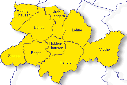
| Locations in the District HERFORD (Source: Wikipedia) |
||||||||||||


| The following Municipal Register contains all places of the "Geschichtlichen Orts-Verzeichnisses" (GOV) of CompGen in HERFORD. By activating the individual buttons in the four columns >Topo<, >SLUB<, >GOV< and >Meyers<, the geographical location of a place can be called up on a map from the geographical OpenTopoMap and Kartenforum or the place descriptions in the GOV-Ortsverzeichnis and Meyers Gazetteer. | ||||||||||||||||||||||||||
| A | B | C | D | E | F | G | H | I | J | K | L | M | N | O | P | Q | R | S | T | U | V | W | X | Y | Z | |
| Community | District | Location Type | GOV | Meyers | Parts of a Community | Type | Coordinates | Topo | WikiM | SLUB | GOV |
| B�nde | Herford | Town |  |
 |
St. Michael (Holsen) | City | 52.2084 N 008.5136 E |  |
 |
 |
|
| Ev.-Luth. Kirche (D�nne) | City | 52.2269 N 008.5827 E | |
|
|
|
St. Joseph (B�nde) | City | 52.1952 N 008.5838 E | |
|
|
|
| Community | District | Location Type | GOV | Meyers | Parts of a Community | Type | Coordinates | Topo | WikiM | SLUB | GOV |
| Enger | Herford | Town | |
|
St. Bonifatius (Eilshausen) | City | 52.1636 N 008.6291 E | |
|
|
|
| St. Dionysius (Enger) | City | 52.1347 N 008.5565 E | |
|
|
|
|||||
| Community | District | Location Type | GOV | Meyers | Parts of a Community | Type | Coordinates | Topo | WikiM | SLUB | GOV |
| Herford | Herford | Town | |
|
M�nster/Herford | City | 52.1156 N 008.6711 E | |
|
|
|
| Community | District | Location Type | GOV | Meyers | Parts of a Community | Type | Coordinates | Topo | WikiM | SLUB | GOV |
| Kirchlengern | Herford | Community | |
|
St. Canisius und St. Xaverius (Quernheim) | Municipality | 52.2430 N 008.6271 E | |
|
|
|
| St. Marien (Kirchlengern) | Municipality | 52.2012 N 008.6438 E | |
|
|
|
|||||
| Community | District | Location Type | GOV | Meyers | Parts of a Community | Type | Coordinates | Topo | WikiM | SLUB | GOV |
| L�hne | Herford | Town | |
|
Mennigh�ffen | City | 52.2182 N 008.7088 E | |
|
|
|
| Gohfeld | City | |
St. Laurentius (L�hne) | City | 52.2004 N 008.7135 E | |
|
|
|
||
| Community | District | Location Type | GOV | Meyers | Parts of a Community | Type | Coordinates | Topo | WikiM | SLUB | GOV |
| R�dinghausen | Herford | Community | |
|
Michaelkirche/ Westkilver | Municipality | 52.2225 N 008.4606 E | |
|
|
|
| Community | District | Location Type | GOV | Meyers | Parts of a Community | Type | Coordinates | Topo | WikiM | SLUB | GOV |
| Spenge | Herford | Town | |
|
St. Joseph (Spenge) | City | 52.1439 N 008.4786 E | |
|
|
|
| Community | District | Location Type | GOV | Meyers | Parts of a Community | Type | Coordinates | Topo | WikiM | SLUB | GOV |
| Vlotho | Herford | Town | |
|
Heilig Kreuz (Vlotho) | City | 52.1633 N 008.8521 E | |
|
|
|
| Vlotho/St.Johannis | City | 52.1692 N 008.8632 E | |
|
|
|
Valdorf | City | 52.1422 N 008.8514 E | |
|
|
|
Vlotho/St.Stephan | City | 52.1671 N 008.8623 E | |
|
|
|
Autobahnkirche Exter | City | 52.1403 N 008.7797 E | |
|
|
|
|
||||||||||