|
|||||||||||
| District OSNABRÐCK - Municipal Register - |
|||||||||||
|
|
|
||||||||||
| District OSNABRUECK on the map of Germany (Source: Wikipedia) |
District OSNABRUECK on the map of Lower Saxony (Source: Wikipedia) |
|||||||||||
|
||||||||||||
|
||||||||||||
| Locations in the District OSNABRUECK (Source: Wikipedia) |
||||||||||||


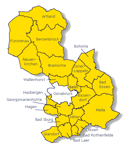
| The following Municipal Register contains all places of the "Geschichtlichen Orts-Verzeichnisses" (GOV) of CompGen in OSNABRÐCK. By activating the individual buttons in the four columns >Topo<, >SLUB<, >GOV< and >Meyers<, the geographical location of a place can be called up on a map from the geographical OpenTopoMap and Kartenforum or the place descriptions in the GOV-Ortsverzeichnis and Meyers Gazetteer. | ||||||||||||||||||||||||||
| A | B | C | D | E | F | G | H | I | J | K | L | M | N | O | P | Q | R | S | T | U | V | W | X | Y | Z | |
| Community | District | Location Type | GOV | Earth | Meyers | Parts of a Community | Type | Coordinates | Topo | WikiM | SLUB | GOV |
| Alfhausen | Osnabr¸ck | Community |  |
 |
 |
Bollenberg | Residential Area | 52.4929 N 007.9049 E |  |
 |
 |
|
| Schleppenburg | Residential Area | 52.4876 N 007.9541 E | |
|
|
|
Bruchhausen | Residential Area | 52.5119 N 007.9826 E | |
|
|
|
Thiene | Hamlet | 52.4872 N 007.9350 E | |
|
|
|
Horst | Residential Area | 52.5069 N 007.9753 E | |
|
|
|
Meppenburg | Residential Area | 52.5257 N 007.9712 E | |
|
|
|
Klein Rechtien | Residential Area | 52.4759 N 007.9366 E | |
|
|
|
Heeke | Hamlet | 52.5183 N 007.9707 E | |
|
|
|
Hadern | Residential Area | 52.5162 N 008.0023 E | |
|
|
|
Bruchm¸hle | Residential Area | 52.4848 N 007.9530 E | |
|
|
|
Wallen | Hamlet | 52.5075 N 007.9440 E | |
|
|
|
Twistel | Residential Area | 52.5296 N 007.9877 E | |
|
|
|
Uphausen | Residential Area | 52.4955 N 007.9244 E | |
|
|
|
Stuckenberg | Residential Area | 52.4862 N 007.9947 E | |
|
|
|
Alfhausen | Village | 52.4986 N 007.9560 E | |
|
|
|
Groþ Rechtien | Residential Area | 52.4768 N 007.9196 E | |
|
|
|
Fullenkamp | Residential Area | 52.4881 N 007.9129 E | |
|
|
|
| Ankum | Osnabr¸ck | Community | |
|
|
Kunkheide | Residential Area | 52.5524 N 007.8858 E | |
|
|
|
| Stockum | Residential Area | 52.5302 N 007.9125 E | |
|
|
|
Rˆlkenberg | Residential Area | 52.5185 N 007.9130 E | |
|
|
|
Starten | Residential Area | 52.5145 N 007.8706 E | |
|
|
|
Brink | Residential Area | 52.5386 N 007.9016 E | |
|
|
|
Druchhorn | Hamlet | 52.5799 N 007.8936 E | |
|
|
|
Brickwedde | Hamlet | 52.5160 N 007.9118 E | |
|
|
|
Holsten | Hamlet | 52.5546 N 007.8382 E | |
|
|
|
Alt R¸ssel | Residential Area | 52.5277 N 007.8942 E | |
|
|
|
Grumfeld | Residential Area | 52.4822 N 007.8806 E | |
|
|
|
Ankum | Village | 52.5437 N 007.8743 E | |
|
|
|
Westrup | Residential Area | 52.5249 N 007.9267 E | |
|
|
|
Grovern | Residential Area | 52.5070 N 007.8826 E | |
|
|
|
R¸ssel | Hamlet | 52.5361 N 007.9024 E | |
|
|
|
Aslage | Hamlet | 52.5399 N 007.8445 E | |
|
|
|
Westerholte | Hamlet | 52.5021 N 007.8632 E | |
|
|
|
Schwetsberg | Residential Area | 52.5559 N 007.8757 E | |
|
|
|
Loxter Ort | Residential Area | 52.5803 N 007.8568 E | |
|
|
|
Forsthaus | Residential Area | 52.4862 N 007.8478 E | |
|
|
|
Walsum | Residential Area | 52.5467 N 007.9026 E | |
|
|
|
T¸tingen | Hamlet | 52.5291 N 007.8680 E | |
|
|
|
| Community | District | Location Type | GOV | Earth | Meyers | Parts of a Community | Type | Coordinates | Topo | WikiM | SLUB | GOV |
| Bad Essen | Osnabr¸ck | Community | |
|
|
Falkenburg | Residential Area | 52.3257 N 008.3574 E | |
|
|
|
| H¸sede | Hamlet | 52.3048 N 008.3751 E | |
|
|
|
Wimmerm¸hle | Residential Area | 52.3151 N 008.4314 E | |
|
|
|
Wehrendorfer Masch | Residential Area | 52.3366 N 008.3109 E | |
|
|
|
Vogelpohl | Residential Area | 52.3365 N 008.4042 E | |
|
|
|
Rabberbr¸chen | Residential Area | 52.3144 N 008.4155 E | |
|
|
|
Senfdamm | Residential Area | 52.3223 N 008.3720 E | |
|
|
|
H¸nnefeld | Residential Area | 52.3354 N 008.3332 E | |
|
|
|
Hˆrdinghausen | Hamlet | 52.3159 N 008.4432 E | |
|
|
|
Wehrendorf | Hamlet | 52.3296 N 008.3121 E | |
|
|
|
Heithˆfen | Hamlet | 52.3521 N 008.4368 E | |
|
|
|
Dahlinghausen | Hamlet | 52.3106 N 008.4586 E | |
|
|
|
Susenburg | Place | |
Bad Essen | Village | 52.3217 N 008.3397 E | |
|
|
|
Leuchtenburg | Residential Area | 52.3173 N 008.3623 E | |
|
|
|
Haus Wimmer | Residential Area | 52.3475 N 008.4244 E | |
|
|
|
Driburg | Residential Area | 52.3423 N 008.4390 E | |
|
|
|
Brockhauserbruch | Residential Area | 52.3530 N 008.3858 E | |
|
|
|
Eielst‰dt | Hamlet | 52.3164 N 008.3563 E | |
|
|
|
Wimmerheide | Residential Area | 52.3522 N 008.4207 E | |
|
|
|
Kalbsiek | Residential Area | 52.2960 N 008.3852 E | |
|
|
|
Harpenfeld | Hamlet | 52.3284 N 008.3458 E | |
|
|
|
Linnerheide | Residential Area | 52.2908 N 008.3919 E | |
|
|
|
Wittlage | Place | 52.3196 N 008.3720 E | |
|
|
|
Linne | Hamlet | 52.2968 N 008.4042 E | |
|
|
|
Lintorf | Village | 52.3066 N 008.4305 E | |
|
|
|
Rabberbruch | Residential Area | 52.3574 N 008.4130 E | |
|
|
|
Lockhausen | Hamlet | 52.3276 N 008.3565 E | |
|
|
|
Ippenburg | Residential Area | 52.3409 N 008.3596 E | |
|
|
|
Osterwiehe | Residential Area | 52.3631 N 008.3587 E | |
|
|
|
Angelburg | Residential Area | 52.3190 N 008.3850 E | |
|
|
|
Angelbeck | Residential Area | 52.3217 N 008.3817 E | |
|
|
|
Rabber | Hamlet | 52.3160 N 008.4072 E | |
|
|
|
Wehrendorferberg | Residential Area | 52.3176 N 008.3001 E | |
|
|
|
Rattinghausen | Residential Area | 52.2881 N 008.3651 E | |
|
|
|
Wimmer | Hamlet | 52.3300 N 008.4302 E | |
|
|
|
Brockhausen | Hamlet | 52.3298 N 008.3891 E | |
|
|
|
Essenerberg | Residential Area | 52.3046 N 008.3260 E | |
|
|
|
Linnermarsch | Residential Area | 52.3054 N 008.4065 E | |
|
|
|
Himmelreich | Residential Area | 52.3330 N 008.3453 E | |
|
|
|
Barkhausen (Bad Essen) | Village | 52.2882 N 008.4179 E | |
|
|
|
H¸sederbruch | Residential Area | 52.3036 N 008.3862 E | |
|
|
|
B¸scherheide | Place | 52.2780 N 008.4557 E | |
|
|
|
Krietenstein | Residential Area | 52.2999 N 008.4070 E | |
|
|
|
| Bad Iburg | Osnabr¸ck | Town | |
|
|
Auf dem Donnerbrink | Residential Area | 52.1172 N 008.0193 E | |
|
|
|
| Glaner M¸hle | Residential Area | 52.1267 N 008.0356 E | |
|
|
|
Groþe Hartlage | Residential Area | 52.1375 N 008.0765 E | |
|
|
|
Albers Hˆfe | Residential Area | 52.1419 N 008.0699 E | |
|
|
|
Ostenfelde | Hamlet | 52.1446 N 008.0180 E | |
|
|
|
Kleine Hartlage | Residential Area | 52.1314 N 008.0743 E | |
|
|
|
In den Hˆfen | Residential Area | 52.1520 N 008.0931 E | |
|
|
|
Am Urberge | Residential Area | 52.1714 N 008.0217 E | |
|
|
|
In den Langen Ellern | Residential Area | 52.1409 N 008.0867 E | |
|
|
|
Hakentempel | Residential Area | 52.1493 N 008.0266 E | |
|
|
|
Riesweg-Siedlung | Residential Area | 52.1469 N 008.0352 E | |
|
|
|
Dingbank-Siedlung | Residential Area | 52.1482 N 008.0393 E | |
|
|
|
Scheventorf | Residential Area | 52.1370 N 008.0353 E | |
|
|
|
Sentrup | Hamlet | 52.1449 N 008.1046 E | |
|
|
|
Glane | Village | 52.1449 N 008.0553 E | |
|
|
|
Urberg | Residential Area | 52.1490 N 008.0895 E | |
|
|
|
Visbeck | Hamlet | 52.1369 N 008.0660 E | |
|
|
|
| Bad Laer | Osnabr¸ck | Community | |
|
|
Winkelsetten | Place | 52.0858 N 008.0842 E | |
|
|
|
| Schwenne | Residential Area | 52.0952 N 008.0700 E | |
|
|
|
Wiemann | Residential Area | 52.0746 N 008.0531 E | |
|
|
|
Feldhaus | Residential Area | 52.1145 N 008.0897 E | |
|
|
|
Vor dem Venne | Residential Area | 52.1061 N 008.0600 E | |
|
|
|
Groþe Hˆrstkamp | Residential Area | 52.0779 N 008.0839 E | |
|
|
|
Hardensetten | Place | 52.0851 N 008.0740 E | |
|
|
|
Kleine Hˆrstkamp | Residential Area | 52.0743 N 008.0856 E | |
|
|
|
Ridder | Residential Area | 52.0805 N 008.0961 E | |
|
|
|
Starke | Residential Area | 52.0843 N 008.0942 E | |
|
|
|
Steinbrink | Residential Area | 52.0933 N 008.0870 E | |
|
|
|
Scheiper | Residential Area | 52.0809 N 008.0728 E | |
|
|
|
Schˆnebeck | Residential Area | 52.1341 N 008.0926 E | |
|
|
|
Hiltermann | Residential Area | 52.0890 N 008.0901 E | |
|
|
|
Groþe Kettler | Residential Area | 52.0969 N 008.1251 E | |
|
|
|
Buschkotte | Residential Area | 52.0941 N 008.1293 E | |
|
|
|
Bˆhne | Residential Area | 52.0825 N 008.1228 E | |
|
|
|
Bevermann | Residential Area | 52.0782 N 008.1144 E | |
|
|
|
Remsede | Place | 52.1292 N 008.1060 E | |
|
|
|
Am Heideweg | Residential Area | 52.0998 N 008.0631 E | |
|
|
|
Auf der Wittenburg | Residential Area | 52.1041 N 008.0741 E | |
|
|
|
Bad Laer | Village | 52.1032 N 008.0915 E | |
|
|
|
M¸schen | Place | 52.0829 N 008.1156 E | |
|
|
|
Wahlmeyer | Residential Area | 52.0839 N 008.0809 E | |
|
|
|
Metten | Residential Area | 52.0764 N 008.1155 E | |
|
|
|
Hˆllmann | Residential Area | 52.0910 N 008.1228 E | |
|
|
|
Jostschulte | Residential Area | 52.0816 N 008.1319 E | |
|
|
|
Jugas | Residential Area | 52.0902 N 008.1110 E | |
|
|
|
L¸chtefeld | Residential Area | 52.0668 N 008.0923 E | |
|
|
|
Knollmeyer | Residential Area | 52.0954 N 008.1246 E | |
|
|
|
Saltenbrock | Residential Area | 52.0787 N 008.0616 E | |
|
|
|
Niebr¸gge | Residential Area | 52.0926 N 008.1270 E | |
|
|
|
Sandfort | Residential Area | 52.0974 N 008.1088 E | |
|
|
|
Westerwiede | Place | 52.1123 N 008.0709 E | |
|
|
|
Schulte im Rodde | Residential Area | 52.0873 N 008.1223 E | |
|
|
|
Tewes-Kampelmann | Residential Area | 52.0820 N 008.1097 E | |
|
|
|
Buntevogel | Residential Area | 52.0802 N 008.0655 E | |
|
|
|
Freye | Residential Area | 52.0798 N 008.0757 E | |
|
|
|
Ossege | Residential Area | 52.0734 N 008.0681 E | |
|
|
|
Kleine Bˆrger | Residential Area | 52.0770 N 008.0643 E | |
|
|
|
Kersten | Residential Area | 52.0839 N 008.0686 E | |
|
|
|
Dieckmeyer | Residential Area | 52.0903 N 008.0692 E | |
|
|
|
Groþe Bˆrger | Residential Area | 52.0734 N 008.0594 E | |
|
|
|
Franke | Residential Area | 52.0838 N 008.0721 E | |
|
|
|
Dierker | Residential Area | 52.0913 N 008.0622 E | |
|
|
|
| Bad Rothenfelde | Osnabr¸ck | Community | |
|
|
Bismarck-H¸tte | Residential Area | 52.1104 N 008.1395 E | |
|
|
|
| Klekamp | Residential Area | 52.0761 N 008.1382 E | |
|
|
|
Wulfek¸hler | Residential Area | 52.0776 N 008.1510 E | |
|
|
|
Klinik Teutoburger Wald | Residential Area | 52.1183 N 008.1536 E | |
|
|
|
Warning | Residential Area | 52.0774 N 008.1554 E | |
|
|
|
Sunderwerth | Residential Area | 52.0801 N 008.1605 E | |
|
|
|
Tarner | Residential Area | 52.0934 N 008.1465 E | |
|
|
|
Temme | Residential Area | 52.0932 N 008.1553 E | |
|
|
|
Springm¸hle | Residential Area | 52.1190 N 008.1683 E | |
|
|
|
Meyer zu Hˆrste | Residential Area | 52.0884 N 008.1405 E | |
|
|
|
Strang | Place | 52.0912 N 008.1747 E | |
|
|
|
Meyer | Residential Area | 52.0891 N 008.1632 E | |
|
|
|
Palsterkamp | Residential Area | 52.1135 N 008.1722 E | |
|
|
|
Godewerth | Residential Area | 52.0916 N 008.1379 E | |
|
|
|
Aschendorf | Place | 52.0957 N 008.1438 E | |
|
|
|
Helfern | Residential Area | 52.0977 N 008.1570 E | |
|
|
|
Heidland | Residential Area | 52.1032 N 008.1828 E | |
|
|
|
Bad Rothenfelde | Place | 52.1102 N 008.1598 E | |
|
|
|
Schl¸ter | Residential Area | 52.0810 N 008.1762 E | |
|
|
|
| Badbergen | Osnabr¸ck | Community | |
|
|
Langen | Hamlet | 52.6094 N 007.9567 E | |
|
|
|
| Kl¸mpkenort | Residential Area | 52.6282 N 007.9440 E | |
|
|
|
Ahrenhorster Ort | Residential Area | 52.6500 N 007.9258 E | |
|
|
|
Auf dem Pannenbrink | Residential Area | 52.6349 N 007.9443 E | |
|
|
|
Auf dem Tessel | Residential Area | 52.6408 N 007.9294 E | |
|
|
|
Wulften | Hamlet | 52.6425 N 007.9907 E | |
|
|
|
Wiefering | Residential Area | 52.6398 N 008.0357 E | |
|
|
|
Hasekamp | Residential Area | 52.6229 N 007.9980 E | |
|
|
|
Grothe | Hamlet | 52.6366 N 007.9616 E | |
|
|
|
Grˆnloh | Hamlet | 52.6241 N 008.0483 E | |
|
|
|
Wehdel | Hamlet | 52.6340 N 008.0244 E | |
|
|
|
Badbergen | Village | 52.6366 N 007.9823 E | |
|
|
|
Groþ Mimmelage | Hamlet | 52.6576 N 007.8946 E | |
|
|
|
Schwarzeort | Residential Area | 52.6470 N 007.9662 E | |
|
|
|
Fresenbrink | Residential Area | 52.6451 N 008.0261 E | |
|
|
|
Schulenburg | Residential Area | 52.6227 N 007.9834 E | |
|
|
|
Wohld | Hamlet | 52.6626 N 008.0042 E | |
|
|
|
Vehs | Hamlet | 52.6405 N 007.9383 E | |
|
|
|
Lechterke | Hamlet | 52.6592 N 007.9766 E | |
|
|
|
Bergfelderort | Residential Area | 52.6500 N 007.9779 E | |
|
|
|
Bubertsort | Residential Area | 52.6472 N 007.9865 E | |
|
|
|
Heide | Residential Area | 52.6462 N 007.9471 E | |
|
|
|
Lage | Residential Area | 52.6361 N 007.9748 E | |
|
|
|
Devern | Residential Area | 52.6250 N 007.9704 E | |
|
|
|
Esslingerheide | Residential Area | 52.6460 N 007.9577 E | |
|
|
|
Engelhorst | Residential Area | 52.6513 N 007.9575 E | |
|
|
|
Lehmkuhle | Residential Area | 52.6406 N 007.9748 E | |
|
|
|
| Barsinghausen | Osnabr¸ck | Town | |
|
|
Noltenburg | Residential Area | 52.3123 N 009.4425 E | |
|
|
|
| Belm | Osnabr¸ck | Community | |
|
|
Oberrielage | Residential Area | 52.3230 N 008.1080 E | |
|
|
|
| Powe | Place | 52.3104 N 008.1169 E | |
|
|
|
Westerheide | Residential Area | 52.3034 N 008.1576 E | |
|
|
|
Halternlandwehr | Residential Area | 52.3035 N 008.1943 E | |
|
|
|
Wellingerhof | Residential Area | 52.2879 N 008.1870 E | |
|
|
|
Astrup | Residential Area | 52.3157 N 008.1586 E | |
|
|
|
Espowe | Residential Area | 52.3471 N 008.1126 E | |
|
|
|
Hinter dem Bruche | Residential Area | 52.3683 N 008.1206 E | |
|
|
|
Hinter dem Felde | Residential Area | 52.3304 N 008.1034 E | |
|
|
|
Klein Haltern | Place | 52.3151 N 008.1706 E | |
|
|
|
Klein Icker | Residential Area | 52.3430 N 008.1228 E | |
|
|
|
Westerheide | Residential Area | 52.3423 N 008.1028 E | |
|
|
|
Eistrup | Residential Area | 52.3199 N 008.1265 E | |
|
|
|
Icker | Place | 52.3388 N 008.1128 E | |
|
|
|
Belm | Village | 52.3023 N 008.1278 E | |
|
|
|
Wellingen | Residential Area | 52.2960 N 008.1789 E | |
|
|
|
Groþ Haltern | Residential Area | 52.3022 N 008.1754 E | |
|
|
|
Vehrte | Farming Community | 52.3416 N 008.1523 E | |
|
|
|
Niederrielage | Residential Area | 52.3268 N 008.1104 E | |
|
|
|
| Berge | Osnabr¸ck | Community | |
|
|
Anten | Hamlet | 52.6370 N 007.7519 E | |
|
|
|
| Dalvers | Hamlet | 52.6280 N 007.7802 E | |
|
|
|
Ackwinkel | Residential Area | 52.5949 N 007.7195 E | |
|
|
|
W¸bbe | Residential Area | 52.6150 N 007.6692 E | |
|
|
|
Lienesch | Residential Area | 52.6176 N 007.6507 E | |
|
|
|
Neustadt | Residential Area | 52.6081 N 007.7541 E | |
|
|
|
Schmunkamp | Residential Area | 52.6142 N 007.6868 E | |
|
|
|
Ruþland | Residential Area | 52.6226 N 007.6234 E | |
|
|
|
Ohrthausen | Residential Area | 52.6305 N 007.6634 E | |
|
|
|
Berge | Village | 52.6220 N 007.7460 E | |
|
|
|
Hekese | Hamlet | 52.5976 N 007.7790 E | |
|
|
|
Wehde | Residential Area | 52.6191 N 007.7735 E | |
|
|
|
Berghausen | Residential Area | 52.6135 N 007.7177 E | |
|
|
|
Upberg | Residential Area | 52.6123 N 007.7396 E | |
|
|
|
Sipe | Residential Area | 52.6062 N 007.7391 E | |
|
|
|
Schmonerbrink | Hamlet | 52.6130 N 007.7511 E | |
|
|
|
Gut Hengholt | Residential Area | 52.6253 N 007.7219 E | |
|
|
|
Lindlage | Residential Area | 52.6034 N 007.7277 E | |
|
|
|
Geverm¸hle | Residential Area | 52.6262 N 007.6994 E | |
|
|
|
Grafeld | Hamlet | 52.6253 N 007.6755 E | |
|
|
|
Stift Bˆrstel | Monastery | 52.6505 N 007.6939 E | |
|
|
|
Hamberg | Residential Area | 52.6180 N 007.6695 E | |
|
|
|
| Bersenbr¸ck | Osnabr¸ck | Town | |
|
|
Priggenhagen | Hamlet | 52.5454 N 007.9538 E | |
|
|
|
| Sandbrink | Residential Area | 52.5535 N 007.9733 E | |
|
|
|
Talge | Hamlet | 52.5903 N 007.9513 E | |
|
|
|
Woltrup | Hamlet | 52.5360 N 007.9404 E | |
|
|
|
Ahausen | Hamlet | 52.5552 N 007.9186 E | |
|
|
|
Quadenort | Residential Area | 52.5682 N 007.9643 E | |
|
|
|
Wehbergen | Hamlet | 52.5275 N 007.9465 E | |
|
|
|
Rothe Heide | Residential Area | 52.5567 N 007.9634 E | |
|
|
|
Hertmann | Hamlet | 52.5705 N 007.9525 E | |
|
|
|
Hastrup | Hamlet | 52.5567 N 007.9668 E | |
|
|
|
Noskenheide | Residential Area | 52.5582 N 007.9387 E | |
|
|
|
Lohbeck | Residential Area | 52.5650 N 007.9331 E | |
|
|
|
Sitter | Residential Area | 52.5565 N 007.9036 E | |
|
|
|
Bersenbr¸ck | Monastery | 52.5549 N 007.9511 E | |
|
|
|
Bokel | Hamlet | 52.5474 N 007.9294 E | |
|
|
|
Am Brink | Residential Area | 52.5529 N 007.9315 E | |
|
|
|
Warnefeld | Residential Area | 52.5850 N 007.9669 E | |
|
|
|
| Bippen | Osnabr¸ck | Community | |
|
|
Bokel | Residential Area | 52.6040 N 007.6857 E | |
|
|
|
| Kerkamp | Residential Area | 52.5630 N 007.6548 E | |
|
|
|
Forsthaus Maiburg | Residential Area | 52.5629 N 007.7548 E | |
|
|
|
Rumke | Hamlet | 52.5379 N 007.7221 E | |
|
|
|
Burkamp | Residential Area | 52.5910 N 007.7533 E | |
|
|
|
Sunderhaus | Residential Area | 52.5674 N 007.7236 E | |
|
|
|
Schokland | Residential Area | 52.5905 N 007.7266 E | |
|
|
|
Rullengersberg | Residential Area | 52.5706 N 007.7334 E | |
|
|
|
Talge | Residential Area | 52.5966 N 007.6461 E | |
|
|
|
S¸ltem¸hle | Residential Area | 52.5533 N 007.7089 E | |
|
|
|
Ohrte | Hamlet | 52.5909 N 007.6794 E | |
|
|
|
Ohrtermersch | Hamlet | 52.5948 N 007.6678 E | |
|
|
|
Lulle | Residential Area | 52.5768 N 007.7041 E | |
|
|
|
Rittergut Lonne | Residential Area | 52.5510 N 007.6651 E | |
|
|
|
Lonnerbecke | Hamlet | 52.5462 N 007.6802 E | |
|
|
|
Haneberg | Residential Area | 52.5798 N 007.6279 E | |
|
|
|
Vechtel | Hamlet | 52.5657 N 007.6366 E | |
|
|
|
Harpke | Residential Area | 52.5459 N 007.7714 E | |
|
|
|
Restrup | Hamlet | 52.5850 N 007.7751 E | |
|
|
|
Dalum | Hamlet | 52.5531 N 007.7303 E | |
|
|
|
Bippen | Village | 52.5808 N 007.7402 E | |
|
|
|
Hartlage | Hamlet | 52.5824 N 007.6970 E | |
|
|
|
Klein Bokern | Hamlet | 52.5364 N 007.7691 E | |
|
|
|
Brockhausen | Residential Area | 52.6086 N 007.6312 E | |
|
|
|
| Bissendorf | Osnabr¸ck | Community | |
|
|
Natbergen | Hamlet | 52.2541 N 008.1415 E | |
|
|
|
| Linne | Hamlet | 52.2648 N 008.2314 E | |
|
|
|
Deitinghausen | Residential Area | 52.2876 N 008.2887 E | |
|
|
|
Krevinghausen | Hamlet | 52.3036 N 008.2557 E | |
|
|
|
Westrup | Hamlet | 52.2838 N 008.2553 E | |
|
|
|
Meckelesch | Residential Area | 52.2769 N 008.1843 E | |
|
|
|
Hiddinghausen | Residential Area | 52.2672 N 008.2826 E | |
|
|
|
Jeggen | Hamlet | 52.2781 N 008.1913 E | |
|
|
|
Grambergen | Hamlet | 52.2757 N 008.2854 E | |
|
|
|
Nemden | Hamlet | 52.2274 N 008.2397 E | |
|
|
|
Ellerbeck | Hamlet | 52.2596 N 008.2531 E | |
|
|
|
Wissingen | Hamlet | 52.2613 N 008.2055 E | |
|
|
|
Im Wellbruch | Residential Area | 52.2401 N 008.1905 E | |
|
|
|
Werscher Berg | Residential Area | 52.2424 N 008.1937 E | |
|
|
|
Dependahl | Residential Area | 52.2330 N 008.2096 E | |
|
|
|
Achelriede | Residential Area | 52.2413 N 008.1707 E | |
|
|
|
Ellinghaus | Residential Area | 52.2290 N 008.1406 E | |
|
|
|
Bettinghaus | Residential Area | 52.2874 N 008.2978 E | |
|
|
|
Ortbergen | Residential Area | 52.2930 N 008.2841 E | |
|
|
|
Feldm¸hle | Residential Area | 52.2642 N 008.2988 E | |
|
|
|
Hˆrsten | Residential Area | 52.2375 N 008.2607 E | |
|
|
|
Auf dem Specken | Residential Area | 52.2540 N 008.2009 E | |
|
|
|
Jeggen-West | Residential Area | 52.2681 N 008.1686 E | |
|
|
|
Stockum | Residential Area | 52.2518 N 008.1937 E | |
|
|
|
Im Siek | Residential Area | 52.2754 N 008.2951 E | |
|
|
|
Purnhagen | Residential Area | 52.2137 N 008.1855 E | |
|
|
|
Rosenm¸hle | Residential Area | 52.2553 N 008.1481 E | |
|
|
|
Bissendorf | Place | 52.2343 N 008.1705 E | |
|
|
|
Schledehausen | Village | 52.2804 N 008.2421 E | |
|
|
|
Schelenburg | Place | 52.2828 N 008.2256 E | |
|
|
|
Gut Stockum | Hamlet | 52.2579 N 008.1642 E | |
|
|
|
Cronsundern | Residential Area | 52.2132 N 008.1564 E | |
|
|
|
Holte | Village | 52.2201 N 008.1875 E | |
|
|
|
Brakerhof | Residential Area | 52.2737 N 008.2260 E | |
|
|
|
Huckriede | Residential Area | 52.2933 N 008.2525 E | |
|
|
|
Am Eichholz | Residential Area | 52.2813 N 008.2100 E | |
|
|
|
Wersche | Hamlet | 52.2472 N 008.2090 E | |
|
|
|
S¸nsbeck | Hamlet | 52.2267 N 008.1750 E | |
|
|
|
Holterberg | Residential Area | 52.2177 N 008.1678 E | |
|
|
|
Himbergen | Hamlet | 52.2300 N 008.1962 E | |
|
|
|
Auf dem Kurrel | Residential Area | 52.2234 N 008.2107 E | |
|
|
|
Lˆsebeck | Residential Area | 52.2564 N 008.2650 E | |
|
|
|
Schloþ Ledenburg | Residential Area | 52.2344 N 008.2428 E | |
|
|
|
Asbrock | Residential Area | 52.2707 N 008.2115 E | |
|
|
|
Auf dem Lechtenbrink | Residential Area | 52.2814 N 008.1886 E | |
|
|
|
Blumenkamp | Residential Area | 52.2790 N 008.2193 E | |
|
|
|
Hengstbrink | Residential Area | 52.2672 N 008.1904 E | |
|
|
|
Im Hadern | Residential Area | 52.2743 N 008.1701 E | |
|
|
|
Ossenbrock | Residential Area | 52.2867 N 008.2133 E | |
|
|
|
Alt Schledehausen | Residential Area | 52.2880 N 008.2310 E | |
|
|
|
Stockumer Mark | Residential Area | 52.2662 N 008.1640 E | |
|
|
|
Schelenburger M¸hle | Residential Area | 52.2792 N 008.2302 E | |
|
|
|
Wulften | Hamlet | 52.3042 N 008.2227 E | |
|
|
|
Uphausen | Hamlet | 52.2369 N 008.1514 E | |
|
|
|
Halle | Residential Area | 52.2397 N 008.2410 E | |
|
|
|
Eistrup | Hamlet | 52.2432 N 008.1539 E | |
|
|
|
West Vorwerk | Residential Area | 52.2622 N 008.1944 E | |
|
|
|
Astrup | Hamlet | 52.2817 N 008.2703 E | |
|
|
|
| Bohmte | Osnabr¸ck | Community | |
|
|
Schweger Moorzentrale | Residential Area | 52.4703 N 008.2431 E | |
|
|
|
| ÷lingen | Residential Area | 52.3451 N 008.2726 E | |
|
|
|
Stirpe | Hamlet | 52.3402 N 008.2866 E | |
|
|
|
An der Haar | Residential Area | 52.4190 N 008.2614 E | |
|
|
|
Schwegermoor-Bauernsiedlung | Residential Area | 52.4633 N 008.2118 E | |
|
|
|
Im G‰nseorte | Residential Area | 52.4350 N 008.2596 E | |
|
|
|
Streithorst | Residential Area | 52.4489 N 008.2797 E | |
|
|
|
Krˆnerhusen | Residential Area | 52.4231 N 008.3007 E | |
|
|
|
Bohmte | Place | 52.3673 N 008.3126 E | |
|
|
|
Eue | Residential Area | 52.3557 N 008.2286 E | |
|
|
|
Wehsand | Residential Area | 52.3852 N 008.2659 E | |
|
|
|
Auf dem Kerlfelde | Residential Area | 52.4215 N 008.2507 E | |
|
|
|
Ovelgˆnne | Residential Area | 52.3716 N 008.3038 E | |
|
|
|
Im Kosackenort | Residential Area | 52.4311 N 008.2742 E | |
|
|
|
Auf dem Brinke | Residential Area | 52.4288 N 008.2666 E | |
|
|
|
Alte Finkenburg | Residential Area | 52.4403 N 008.2673 E | |
|
|
|
Hohe Hahr | Residential Area | 52.3801 N 008.3428 E | |
|
|
|
Langelage | Residential Area | 52.3692 N 008.2465 E | |
|
|
|
Ashorn | Residential Area | 52.3817 N 008.2962 E | |
|
|
|
An der Hunte | Residential Area | 52.4104 N 008.3032 E | |
|
|
|
Bohmterheide | Residential Area | 52.3743 N 008.3470 E | |
|
|
|
Arenshorst | Residential Area | 52.3582 N 008.2892 E | |
|
|
|
Hunteburg | Place | 52.4379 N 008.2718 E | |
|
|
|
Hinterbruch | Residential Area | 52.3807 N 008.2902 E | |
|
|
|
Welplage | Village | 52.4277 N 008.2661 E | |
|
|
|
Schwege | Village | 52.4466 N 008.2612 E | |
|
|
|
Meyerhˆfen | Residential Area | 52.4338 N 008.2976 E | |
|
|
|
Hinterfelde | Residential Area | 52.3663 N 008.3291 E | |
|
|
|
Kleine Heide | Residential Area | 52.4342 N 008.2917 E | |
|
|
|
Schwegermoor | Residential Area | 52.4579 N 008.2546 E | |
|
|
|
Laar | Residential Area | 52.3558 N 008.2541 E | |
|
|
|
Feldkamp | Residential Area | 52.3621 N 008.2664 E | |
|
|
|
÷lingen | Hamlet | 52.3447 N 008.2807 E | |
|
|
|
Herringhausen | Hamlet | 52.3510 N 008.2464 E | |
|
|
|
Nierh¸sen | Residential Area | 52.4458 N 008.2856 E | |
|
|
|
Schafbrink | Residential Area | 52.4415 N 008.2913 E | |
|
|
|
Lecker | Residential Area | 52.3556 N 008.2681 E | |
|
|
|
Lecker M¸hle | Residential Area | 52.3447 N 008.2536 E | |
|
|
|
Auf der Bruchheide | Residential Area | 52.3799 N 008.3074 E | |
|
|
|
Heesingen | Residential Area | 52.4416 N 008.2975 E | |
|
|
|
Osterwiehe | Residential Area | 52.3640 N 008.3589 E | |
|
|
|
| Bramsche | Osnabr¸ck | Town | |
|
|
Feldflach | Residential Area | 52.3884 N 007.9307 E | |
|
|
|
| Hesepe | Hamlet | 52.4434 N 007.9599 E | |
|
|
|
Frankensundern | Residential Area | 52.3648 N 008.0474 E | |
|
|
|
Hinterm Berge | Residential Area | 52.3693 N 008.0127 E | |
|
|
|
B¸hren | Residential Area | 52.4605 N 007.8778 E | |
|
|
|
Balkum | Hamlet | 52.4599 N 007.8992 E | |
|
|
|
Gr¸negras | Residential Area | 52.4154 N 007.9220 E | |
|
|
|
Gut Barenaue | Residential Area | 52.4088 N 008.1169 E | |
|
|
|
Achmer | Hamlet | 52.3951 N 007.9353 E | |
|
|
|
Wackum | Residential Area | 52.3853 N 007.9399 E | |
|
|
|
Wittenfelde | Residential Area | 52.4459 N 008.0548 E | |
|
|
|
Bockwiede | Residential Area | 52.4734 N 007.8919 E | |
|
|
|
Evinghausen | Hamlet | 52.3778 N 008.0973 E | |
|
|
|
Helmkamp | Residential Area | 52.3762 N 008.1104 E | |
|
|
|
Sch¸ttenheide | Residential Area | 52.3882 N 008.0486 E | |
|
|
|
Bottum | Residential Area | 52.4726 N 007.8617 E | |
|
|
|
Uthof | Residential Area | 52.4380 N 008.0378 E | |
|
|
|
Larberge | Residential Area | 52.3916 N 007.9251 E | |
|
|
|
Westerhausen | Residential Area | 52.4221 N 007.9347 E | |
|
|
|
Eikern | Residential Area | 52.4052 N 008.0242 E | |
|
|
|
Ueffeln | Village | 52.4480 N 007.8752 E | |
|
|
|
Tˆmmern | Residential Area | 52.4084 N 007.9152 E | |
|
|
|
Epe | Hamlet | 52.4322 N 008.0094 E | |
|
|
|
Engter | Village | 52.3876 N 008.0618 E | |
|
|
|
Bramsche Gartenstadt | Residential Area | 52.4069 N 008.0041 E | |
|
|
|
Sandwisch | Residential Area | 52.4000 N 007.9819 E | |
|
|
|
B¸hren | Residential Area | 52.4230 N 007.9946 E | |
|
|
|
Zur Horst | Residential Area | 52.4558 N 008.0230 E | |
|
|
|
Uptrup | Residential Area | 52.3701 N 008.0882 E | |
|
|
|
Alt Barenaue | Residential Area | 52.4182 N 008.1189 E | |
|
|
|
Hemke | Residential Area | 52.4032 N 007.9553 E | |
|
|
|
M¸hlenort | Residential Area | 52.3766 N 008.0528 E | |
|
|
|
Knapp | Residential Area | 52.4101 N 007.9511 E | |
|
|
|
Strang | Residential Area | 52.3870 N 008.0325 E | |
|
|
|
Renzenbrink | Residential Area | 52.4181 N 007.9613 E | |
|
|
|
Riesau | Residential Area | 52.4704 N 007.9004 E | |
|
|
|
Rote M¸hle | Residential Area | 52.4021 N 008.0899 E | |
|
|
|
Westerheide | Residential Area | 52.3826 N 008.0505 E | |
|
|
|
Rothenburg | Residential Area | 52.4073 N 008.1079 E | |
|
|
|
Glindkamp | Residential Area | 52.4401 N 007.9498 E | |
|
|
|
Huxelort | Residential Area | 52.3980 N 008.0740 E | |
|
|
|
Lappenstuhl | Place | 52.4188 N 008.0549 E | |
|
|
|
Kalkriese | Hamlet | 52.4122 N 008.0977 E | |
|
|
|
Stapelberg | Residential Area | 52.4302 N 007.9433 E | |
|
|
|
Sˆgeln | Hamlet | 52.4550 N 008.0049 E | |
|
|
|
Schleptrup | Hamlet | 52.3905 N 008.0309 E | |
|
|
|
Malgarten | Residential Area | 52.4485 N 008.0267 E | |
|
|
|
Schagen | Residential Area | 52.3885 N 007.9616 E | |
|
|
|
Penterknapp | Residential Area | 52.3816 N 007.9924 E | |
|
|
|
Pente | Hamlet | 52.3893 N 007.9689 E | |
|
|
|
Strohe | Residential Area | 52.3921 N 007.9961 E | |
|
|
|
Garlich | Residential Area | 52.4552 N 007.8694 E | |
|
|
|
Wasserburg Alt Barenaue | Residential Area | 52.4220 N 008.1252 E | |
|
|
|
Blankenburg | Residential Area | 52.4125 N 008.0886 E | |
|
|
|
Ellhorn | Residential Area | 52.4179 N 008.0045 E | |
|
|
|
Steinburg | Residential Area | 52.4266 N 007.9820 E | |
|
|
|
Endebrock | Residential Area | 52.4174 N 008.0824 E | |
|
|
|
Haselberg | Residential Area | 52.4195 N 007.8978 E | |
|
|
|
Kolkort | Residential Area | 52.4295 N 007.9852 E | |
|
|
|
Landrostei | Residential Area | 52.4461 N 007.9196 E | |
|
|
|
L¸deke | Residential Area | 52.3984 N 007.9279 E | |
|
|
|
Menkhaus | Residential Area | 52.3984 N 008.0434 E | |
|
|
|
Lutter | Residential Area | 52.4196 N 008.1139 E | |
|
|
|
Meyerhof | Residential Area | 52.3858 N 007.9448 E | |
|
|
|
Purenkamp | Residential Area | 52.4346 N 007.9778 E | |
|
|
|
Rahe | Residential Area | 52.3966 N 007.9572 E | |
|
|
|
| Community | District | Location Type | GOV | Earth | Meyers | Parts of a Community | Type | Coordinates | Topo | WikiM | SLUB | GOV |
| Dissen am Teutoburger Wald | Osnabr¸ck | Town | |
|
|
Gr‰fenwiese | Residential Area | 52.1033 N 008.2139 E | |
|
|
|
| Timmern | Residential Area | 52.1229 N 008.1674 E | |
|
|
|
Bahnhof Dissen-Bad Rothenfelde | Residential Area | 52.1110 N 008.1858 E | |
|
|
|
B¸cker | Residential Area | 52.0950 N 008.2059 E | |
|
|
|
Kneehans | Residential Area | 52.0931 N 008.1871 E | |
|
|
|
Schollhof | Residential Area | 52.1196 N 008.2103 E | |
|
|
|
Aschen | Place | 52.1134 N 008.2223 E | |
|
|
|
Meyer | Residential Area | 52.0910 N 008.1870 E | |
|
|
|
Ruschhaupt | Residential Area | 52.0755 N 008.1835 E | |
|
|
|
Wehmˆller | Residential Area | 52.0816 N 008.1981 E | |
|
|
|
Hˆhner | Residential Area | 52.0870 N 008.1869 E | |
|
|
|
Nolle | Residential Area | 52.1266 N 008.1936 E | |
|
|
|
Dallhof | Residential Area | 52.1010 N 008.1900 E | |
|
|
|
Erpen | Place | 52.1191 N 008.1726 E | |
|
|
|
Dahausen | Residential Area | 52.1070 N 008.2085 E | |
|
|
|
| Community | District | Location Type | GOV | Earth | Meyers | Parts of a Community | Type | Coordinates | Topo | WikiM | SLUB | GOV |
| Eggerm¸hlen | Osnabr¸ck | Community | |
|
|
Stottenhausen | Residential Area | 52.5698 N 007.7766 E | |
|
|
|
| Maihaus | Residential Area | 52.5592 N 007.7670 E | |
|
|
|
Burlage | Residential Area | 52.5828 N 007.8035 E | |
|
|
|
Branneke | Residential Area | 52.5766 N 007.7875 E | |
|
|
|
Sussum | Hamlet | 52.5601 N 007.7983 E | |
|
|
|
Striekel | Residential Area | 52.5545 N 007.8163 E | |
|
|
|
Krevinghausen | Residential Area | 52.5520 N 007.8068 E | |
|
|
|
Sundern | Residential Area | 52.5345 N 007.8074 E | |
|
|
|
Besten | Hamlet | 52.5474 N 007.8119 E | |
|
|
|
D¸ckinghaus | Residential Area | 52.5489 N 007.8255 E | |
|
|
|
Eggerm¸hlen | Place | 52.5688 N 007.8168 E | |
|
|
|
Bockraden | Hamlet | 52.5790 N 007.8025 E | |
|
|
|
Dˆthen | Hamlet | 52.5703 N 007.7851 E | |
|
|
|
Bentlage | Residential Area | 52.5456 N 007.8033 E | |
|
|
|
Basum | Hamlet | 52.5671 N 007.8232 E | |
|
|
|
| Community | District | Location Type | GOV | Earth | Meyers | Parts of a Community | Type | Coordinates | Topo | WikiM | SLUB | GOV |
| F¸rstenau | Osnabr¸ck | Town | |
|
|
Anterhof | Residential Area | 52.5220 N 007.6959 E | |
|
|
|
| Neustadt | Residential Area | 52.4946 N 007.6330 E | |
|
|
|
Settrup | Hamlet | 52.4862 N 007.6225 E | |
|
|
|
Stallkamp | Residential Area | 52.5295 N 007.6954 E | |
|
|
|
Hollenstede | Hamlet | 52.4941 N 007.6819 E | |
|
|
|
Ravensberg | Residential Area | 52.4985 N 007.7377 E | |
|
|
|
Karwisch | Residential Area | 52.5129 N 007.7535 E | |
|
|
|
Marienstift | Residential Area | 52.5171 N 007.7363 E | |
|
|
|
Hˆne | Hamlet | 52.5205 N 007.6332 E | |
|
|
|
Am Pottebruch | Residential Area | 52.5139 N 007.6651 E | |
|
|
|
Kranenpohl | Residential Area | 52.5333 N 007.6664 E | |
|
|
|
Emskamp | Residential Area | 52.4670 N 007.6438 E | |
|
|
|
Kellinghausen | Hamlet | 52.5207 N 007.7323 E | |
|
|
|
Holle | Residential Area | 52.4815 N 007.6764 E | |
|
|
|
Losekamp | Residential Area | 52.4927 N 007.7136 E | |
|
|
|
Hˆrsten | Residential Area | 52.4786 N 007.7030 E | |
|
|
|
Schwagstorf | Village | 52.5186 N 007.7464 E | |
|
|
|
Am G¸ltum | Residential Area | 52.5280 N 007.6887 E | |
|
|
|
Auf den Benken | Residential Area | 52.5112 N 007.7617 E | |
|
|
|
Groþe Haar | Residential Area | 52.4715 N 007.6677 E | |
|
|
|
Welperort | Residential Area | 52.4856 N 007.6420 E | |
|
|
|
Hagenbeck | Residential Area | 52.4907 N 007.6964 E | |
|
|
|
Wegem¸hlen | Residential Area | 52.5226 N 007.7009 E | |
|
|
|
Achelbrook | Residential Area | 52.5000 N 007.6674 E | |
|
|
|
Achterkamp | Residential Area | 52.5065 N 007.7434 E | |
|
|
|
Poggenort | Residential Area | 52.4919 N 007.6234 E | |
|
|
|
L¸tkeberge | Hamlet | 52.5169 N 007.7111 E | |
|
|
|
Stˆnneberg | Residential Area | 52.5253 N 007.7568 E | |
|
|
|
Breitenstein | Residential Area | 52.5275 N 007.7793 E | |
|
|
|
Muckenbecke | Residential Area | 52.5314 N 007.7397 E | |
|
|
|
Am Hamberg | Residential Area | 52.5284 N 007.6577 E | |
|
|
|
Ettenfeld | Residential Area | 52.5290 N 007.6790 E | |
|
|
|
Im Mersche | Residential Area | 52.5177 N 007.6606 E | |
|
|
|
Sellberg-Utdrift | Residential Area | 52.5173 N 007.7018 E | |
|
|
|
Neuenstadt | Residential Area | 52.4945 N 007.6723 E | |
|
|
|
Bedinghausen | Residential Area | 52.5327 N 007.7154 E | |
|
|
|
| Community | District | Location Type | GOV | Earth | Meyers | Parts of a Community | Type | Coordinates | Topo | WikiM | SLUB | GOV |
| Garbsen | Osnabr¸ck | Town | |
|
|
Heitlingen | Place | 52.4679 N 009.6236 E | |
|
|
|
| Gehrde | Osnabr¸ck | Community | |
|
|
R¸sfort | Hamlet | 52.5892 N 008.0044 E | |
|
|
|
| Schevenriede | Residential Area | 52.5637 N 007.9932 E | |
|
|
|
Kˆnigsort | Residential Area | 52.5681 N 008.0090 E | |
|
|
|
Vornholt | Residential Area | 52.5964 N 008.0370 E | |
|
|
|
Kaiserort | Residential Area | 52.5722 N 007.9886 E | |
|
|
|
Holtheide | Residential Area | 52.5349 N 008.0309 E | |
|
|
|
Twelbeck | Residential Area | 52.5915 N 008.0479 E | |
|
|
|
Billenkamp | Residential Area | 52.5939 N 008.0017 E | |
|
|
|
Wehrenberg | Residential Area | 52.5401 N 008.0023 E | |
|
|
|
Helle | Hamlet | 52.6008 N 008.0326 E | |
|
|
|
Groþ Drehle | Hamlet | 52.5470 N 008.0102 E | |
|
|
|
Klein Drehle | Hamlet | 52.5382 N 008.0122 E | |
|
|
|
Gehrde | Village | 52.5777 N 008.0069 E | |
|
|
|
| Georgsmarienh¸tte | Osnabr¸ck | Town | |
|
|
Osthoff Rittergut | Residential Area | 52.2223 N 008.0558 E | |
|
|
|
| Osterberg | Residential Area | 52.2117 N 008.0542 E | |
|
|
|
Limberg | Residential Area | 52.1681 N 008.1168 E | |
|
|
|
Oesede | Village | 52.1999 N 008.0669 E | |
|
|
|
Im Laubbrink | Residential Area | 52.2061 N 008.1243 E | |
|
|
|
Am Musenberg | Residential Area | 52.1907 N 008.1018 E | |
|
|
|
Auf der Hohen Linde | Residential Area | 52.2124 N 008.1072 E | |
|
|
|
Holzhausen (Georgsmarienh¸tte) | City Subdistrict | |
Brannenheide | Residential Area | 52.1797 N 008.1298 E | |
|
|
|
Malbergen | Residential Area | 52.2194 N 008.0372 E | |
|
|
|
M¸ndrup | Hamlet | 52.2214 N 008.1311 E | |
|
|
|
Haus Brinke | Residential Area | 52.2102 N 008.0888 E | |
|
|
|
Schˆppersiedlung | Residential Area | 52.1972 N 008.0176 E | |
|
|
|
Bardinghaus | Residential Area | 52.1957 N 008.0431 E | |
|
|
|
Kiffenbrink | Residential Area | 52.1904 N 008.0689 E | |
|
|
|
Hengelsberg | Residential Area | 52.2294 N 008.1228 E | |
|
|
|
H¸lsebusch | Residential Area | 52.2249 N 008.0709 E | |
|
|
|
Im Sutarb | Residential Area | 52.1895 N 008.1170 E | |
|
|
|
Westrup | Residential Area | 52.2241 N 008.0114 E | |
|
|
|
Siedlung Dˆrenberg | Residential Area | 52.1885 N 008.0658 E | |
|
|
|
Holsten | Hamlet | 52.2150 N 008.1378 E | |
|
|
|
Niederholthaus | Residential Area | 52.2166 N 008.0192 E | |
|
|
|
Steinigerturm | Residential Area | 52.2033 N 008.1299 E | |
|
|
|
Osterdamm | Residential Area | 52.1976 N 008.0943 E | |
|
|
|
Harderburg | Residential Area | 52.2292 N 008.0532 E | |
|
|
|
In der M¸hlenbreite | Residential Area | 52.2013 N 008.1036 E | |
|
|
|
Stertenbrink | Residential Area | 52.2120 N 007.9995 E | |
|
|
|
Alt-Georgsmarienh¸tte | City Subdistrict | 52.2068 N 008.0353 E | |
|
|
|
Harderberg | Place | 52.2181 N 008.0771 E | |
|
|
|
Karolinenhˆhe | Residential Area | 52.2001 N 008.0663 E | |
|
|
|
Drˆper | Hamlet | 52.1978 N 008.0834 E | |
|
|
|
Holsten-M¸ndrup | Place | 52.2194 N 008.1348 E | |
|
|
|
Holzhausen | Farming Community | 52.2192 N 008.0133 E | |
|
|
|
Kloster Oesede | Hamlet | 52.2042 N 008.1131 E | |
|
|
|
| Glandorf | Osnabr¸ck | Community | |
|
|
Groþe Hartlage | Residential Area | 52.0874 N 007.9043 E | |
|
|
|
| Stockhoff | Residential Area | 52.0860 N 007.9881 E | |
|
|
|
Strothof | Residential Area | 52.1001 N 007.9831 E | |
|
|
|
Winterberg | Residential Area | 52.0924 N 007.9621 E | |
|
|
|
Aupke | Residential Area | 52.0687 N 007.9067 E | |
|
|
|
Bastwˆste | Residential Area | 52.0509 N 007.9443 E | |
|
|
|
Bˆrnhorst | Residential Area | 52.0586 N 007.9239 E | |
|
|
|
Brandmann | Residential Area | 52.0675 N 007.9287 E | |
|
|
|
Ellerbrock | Residential Area | 52.0657 N 007.9419 E | |
|
|
|
Narendorf | Residential Area | 52.0875 N 007.9834 E | |
|
|
|
Groþe Nieþe | Residential Area | 52.0871 N 007.9081 E | |
|
|
|
Gut Oedingberge | Residential Area | 52.0570 N 007.9397 E | |
|
|
|
Harenbrock | Residential Area | 52.0719 N 007.9223 E | |
|
|
|
Hessmann | Residential Area | 52.0674 N 007.9103 E | |
|
|
|
Inkrot | Residential Area | 52.0409 N 007.9618 E | |
|
|
|
K‰lker | Residential Area | 52.0499 N 007.9309 E | |
|
|
|
Langhorst | Residential Area | 52.0627 N 007.9145 E | |
|
|
|
L¸ckener | Residential Area | 52.0725 N 007.9265 E | |
|
|
|
Mennemann | Residential Area | 52.0512 N 007.9377 E | |
|
|
|
Reher | Residential Area | 52.0748 N 007.9109 E | |
|
|
|
Br¸ggemann | Residential Area | 52.0843 N 007.8965 E | |
|
|
|
Haselmann | Residential Area | 52.1054 N 007.9761 E | |
|
|
|
Thies | Residential Area | 52.0542 N 007.9246 E | |
|
|
|
Vor der Landwehr | Residential Area | 52.0711 N 007.9667 E | |
|
|
|
Weber | Residential Area | 52.0644 N 007.9836 E | |
|
|
|
Wiesmann | Residential Area | 52.0716 N 007.9818 E | |
|
|
|
Auf dem Hemeling | Residential Area | 52.1011 N 007.9708 E | |
|
|
|
Baumann | Residential Area | 52.0865 N 007.9653 E | |
|
|
|
Diekhoff | Residential Area | 52.0974 N 007.9671 E | |
|
|
|
Dr¸cker | Residential Area | 52.0845 N 007.9645 E | |
|
|
|
Schulze-Becking | Residential Area | 52.0864 N 007.9914 E | |
|
|
|
Gildehaus | Residential Area | 52.0936 N 007.9800 E | |
|
|
|
Schulze-Mˆnking | Residential Area | 52.0965 N 007.9552 E | |
|
|
|
Hˆgemann | Residential Area | 52.0851 N 007.9773 E | |
|
|
|
Holtkamp | Residential Area | 52.0978 N 007.9318 E | |
|
|
|
Sudendorf | Place | 52.0629 N 007.9961 E | |
|
|
|
Jostpille | Residential Area | 52.0831 N 007.9573 E | |
|
|
|
Aubke | Residential Area | 52.0734 N 007.9631 E | |
|
|
|
Mechelhoff | Residential Area | 52.0928 N 007.9669 E | |
|
|
|
Wesselkock | Residential Area | 52.0653 N 007.9339 E | |
|
|
|
Potthoff | Residential Area | 52.0893 N 007.9614 E | |
|
|
|
Riestenpatt | Residential Area | 52.0679 N 007.9752 E | |
|
|
|
Dr¸cker | Residential Area | 52.0628 N 007.9457 E | |
|
|
|
Rosenbusch | Residential Area | 52.0838 N 008.0116 E | |
|
|
|
Schwegmann | Residential Area | 52.0700 N 007.9365 E | |
|
|
|
Hagedorn | Residential Area | 52.0955 N 008.0271 E | |
|
|
|
Herbermann | Residential Area | 52.0722 N 008.0238 E | |
|
|
|
Hoffmann | Residential Area | 52.0886 N 007.9191 E | |
|
|
|
Hollmann | Residential Area | 52.0782 N 008.0231 E | |
|
|
|
Laumann | Residential Area | 52.0792 N 007.8991 E | |
|
|
|
Laumann | Residential Area | 52.0916 N 008.0060 E | |
|
|
|
L¸tke | Residential Area | 52.0922 N 008.0267 E | |
|
|
|
Merschm¸hle | Residential Area | 52.0821 N 008.0166 E | |
|
|
|
Dallm¸hle | Residential Area | 52.0943 N 008.0163 E | |
|
|
|
Pues | Residential Area | 52.0800 N 008.0215 E | |
|
|
|
Upmann | Residential Area | 52.0740 N 008.0029 E | |
|
|
|
Stroer | Residential Area | 52.0961 N 008.0094 E | |
|
|
|
Eggert | Residential Area | 52.0740 N 008.0468 E | |
|
|
|
Hamer | Residential Area | 52.0757 N 008.0290 E | |
|
|
|
Hothneyer | Residential Area | 52.0665 N 008.0522 E | |
|
|
|
H¸lsmann | Residential Area | 52.0820 N 008.0440 E | |
|
|
|
Lauhoff | Residential Area | 52.0766 N 008.0336 E | |
|
|
|
Schulke | Residential Area | 52.0650 N 008.0464 E | |
|
|
|
Walke | Residential Area | 52.0780 N 008.0416 E | |
|
|
|
Westendorf | Place | 52.0700 N 007.9631 E | |
|
|
|
Averfehrden | Place | 52.0873 N 007.9649 E | |
|
|
|
Pues | Residential Area | 52.0703 N 007.9491 E | |
|
|
|
Hˆlker | Residential Area | 52.0627 N 007.9922 E | |
|
|
|
H¸lsmann | Residential Area | 52.0937 N 007.9834 E | |
|
|
|
Wulfert | Residential Area | 52.0534 N 007.9432 E | |
|
|
|
Averesch | Residential Area | 52.0454 N 007.9632 E | |
|
|
|
Eichholz | Residential Area | 52.0616 N 008.0057 E | |
|
|
|
Frese | Residential Area | 52.0553 N 007.9912 E | |
|
|
|
Gerding | Residential Area | 52.0467 N 007.9560 E | |
|
|
|
Glˆsker | Residential Area | 52.0393 N 007.9686 E | |
|
|
|
Groþe Brockmann | Residential Area | 52.0553 N 007.9717 E | |
|
|
|
Gut Bollen | Residential Area | 52.0449 N 007.9859 E | |
|
|
|
Dingwerth | Residential Area | 52.0752 N 008.0235 E | |
|
|
|
Heithaus | Residential Area | 52.0431 N 007.9739 E | |
|
|
|
Uhlenhake | Residential Area | 52.0810 N 007.9093 E | |
|
|
|
Horstmann | Residential Area | 52.0372 N 007.9803 E | |
|
|
|
Kleine Brockmann | Residential Area | 52.0525 N 007.9794 E | |
|
|
|
M¸ller | Residential Area | 52.0637 N 008.0046 E | |
|
|
|
Niesse | Residential Area | 52.0699 N 008.0051 E | |
|
|
|
Papenbrock | Residential Area | 52.0669 N 007.9900 E | |
|
|
|
Recker | Residential Area | 52.0636 N 007.9964 E | |
|
|
|
Recker | Residential Area | 52.0667 N 008.0064 E | |
|
|
|
Riese | Residential Area | 52.0759 N 007.9951 E | |
|
|
|
Schmidt | Residential Area | 52.0666 N 008.0097 E | |
|
|
|
Steinhorst | Residential Area | 52.0574 N 008.0091 E | |
|
|
|
Havermann | Residential Area | 52.0714 N 008.0087 E | |
|
|
|
Glandorf | Place | 52.0854 N 008.0010 E | |
|
|
|
Lackmann | Residential Area | 52.0747 N 007.9599 E | |
|
|
|
Kr¸mpelmann | Residential Area | 52.0753 N 007.9609 E | |
|
|
|
Harwerth | Residential Area | 52.0698 N 007.9880 E | |
|
|
|
Kˆnig | Residential Area | 52.0807 N 007.9665 E | |
|
|
|
Gerwesmann | Residential Area | 52.0788 N 007.9855 E | |
|
|
|
Bischof | Residential Area | 52.0798 N 007.9907 E | |
|
|
|
Mersch | Residential Area | 52.0828 N 008.0115 E | |
|
|
|
Brook | Residential Area | 52.0919 N 008.0271 E | |
|
|
|
Pille | Residential Area | 52.0821 N 007.9737 E | |
|
|
|
Laudiek | Residential Area | 52.0932 N 008.0006 E | |
|
|
|
Schierloh | Place | 52.0756 N 008.0363 E | |
|
|
|
Schwege | Place | 52.0744 N 007.9317 E | |
|
|
|
| Community | District | Location Type | GOV | Earth | Meyers | Parts of a Community | Type | Coordinates | Topo | WikiM | SLUB | GOV |
| Hagen am Teutoburger Wald | Osnabr¸ck | Community | |
|
|
Berelsmann | Residential Area | 52.1873 N 007.9305 E | |
|
|
|
| Kriege | Residential Area | 52.1886 N 007.9287 E | |
|
|
|
Winter | Residential Area | 52.1844 N 007.9975 E | |
|
|
|
Rhotert | Residential Area | 52.1992 N 007.9609 E | |
|
|
|
Wilxmann | Residential Area | 52.2041 N 007.9949 E | |
|
|
|
Im Brook | Residential Area | 52.1904 N 007.9941 E | |
|
|
|
Sprengelmeyer | Residential Area | 52.1787 N 007.9961 E | |
|
|
|
Meyer to Bergte | Residential Area | 52.1965 N 007.9380 E | |
|
|
|
Mentrup | Hamlet | 52.1883 N 007.9890 E | |
|
|
|
Franksmann | Residential Area | 52.1969 N 007.9569 E | |
|
|
|
Pˆtter | Residential Area | 52.2035 N 007.9497 E | |
|
|
|
Natruper M¸hle | Residential Area | 52.2199 N 007.9249 E | |
|
|
|
Meyer zu Mecklendorf | Residential Area | 52.1929 N 007.9146 E | |
|
|
|
Borgelt | Residential Area | 52.2038 N 007.9747 E | |
|
|
|
Konersmann | Residential Area | 52.2072 N 007.9375 E | |
|
|
|
Natrup-Hagen | Hamlet | 52.2048 N 007.9296 E | |
|
|
|
Groþheide | Hamlet | 52.2112 N 007.9781 E | |
|
|
|
Im Himmelreich | Residential Area | 52.1861 N 007.9850 E | |
|
|
|
Vollmer | Residential Area | 52.1843 N 007.9924 E | |
|
|
|
Meyer zu Gellenbeck | Residential Area | 52.2013 N 007.9509 E | |
|
|
|
Stramann | Residential Area | 52.2056 N 007.9053 E | |
|
|
|
Sudenfeld | Hamlet | 52.1821 N 007.9371 E | |
|
|
|
Altenhagen | Residential Area | 52.1996 N 007.9824 E | |
|
|
|
Hagen am Teutoburger Wald | Village | 52.1913 N 007.9534 E | |
|
|
|
Groþe Wˆrdemann | Residential Area | 52.1908 N 007.9452 E | |
|
|
|
Westenberg | Residential Area | 52.1952 N 007.9275 E | |
|
|
|
Am Borgberg | Residential Area | 52.1886 N 007.9654 E | |
|
|
|
Beckerode | Hamlet | 52.1922 N 007.9633 E | |
|
|
|
Kleine Wˆrdemann | Residential Area | 52.1878 N 007.9472 E | |
|
|
|
Gellenbeck | Hamlet | 52.1970 N 007.9445 E | |
|
|
|
Wortmann | Residential Area | 52.1887 N 007.9765 E | |
|
|
|
Schulte-Brinke | Residential Area | 52.2016 N 007.9762 E | |
|
|
|
Hartmeier | Residential Area | 52.2064 N 007.9881 E | |
|
|
|
Voþ | Residential Area | 52.2151 N 007.9616 E | |
|
|
|
Gretzmann | Residential Area | 52.1815 N 007.9441 E | |
|
|
|
Witte-Elixmann | Residential Area | 52.2099 N 007.9401 E | |
|
|
|
Osterhaus | Residential Area | 52.2099 N 007.9092 E | |
|
|
|
Nollmann | Residential Area | 52.2160 N 007.9194 E | |
|
|
|
Am Ellenberg | Residential Area | 52.1974 N 007.9983 E | |
|
|
|
Kasselmann | Residential Area | 52.1913 N 007.9621 E | |
|
|
|
Rottmann | Residential Area | 52.1869 N 007.9719 E | |
|
|
|
Meyer zu Natrup | Residential Area | 52.2129 N 007.9293 E | |
|
|
|
Achter de Welt | Residential Area | 52.1868 N 008.0072 E | |
|
|
|
| Hannover | Osnabr¸ck | Town | |
|
|
Glocksee | Residential Area | 52.3716 N 009.7208 E | |
|
|
|
| Hasbergen | Osnabr¸ck | Community | |
|
|
Dreier | Residential Area | 52.2431 N 007.9460 E | |
|
|
|
| Ohrbeck | Place | 52.2311 N 007.9813 E | |
|
|
|
Niemann | Residential Area | 52.2225 N 007.9919 E | |
|
|
|
Gaste | Place | 52.2562 N 007.9533 E | |
|
|
|
Hasbergen | Place | 52.2362 N 007.9582 E | |
|
|
|
Wiebusch | Residential Area | 52.2297 N 007.9333 E | |
|
|
|
Schrˆder | Residential Area | 52.2260 N 007.9394 E | |
|
|
|
Schierke | Residential Area | 52.2328 N 007.9506 E | |
|
|
|
Pott | Residential Area | 52.2318 N 007.9540 E | |
|
|
|
Horstmann | Residential Area | 52.2381 N 007.9334 E | |
|
|
|
Grave | Residential Area | 52.2220 N 007.9341 E | |
|
|
|
Gˆsmann | Residential Area | 52.2397 N 007.9577 E | |
|
|
|
Heinkengarten | Residential Area | 52.2506 N 007.9487 E | |
|
|
|
Vˆller | Residential Area | 52.2246 N 007.9914 E | |
|
|
|
Knochenort | Residential Area | 52.2652 N 007.9535 E | |
|
|
|
Nieberg | Residential Area | 52.2155 N 007.9771 E | |
|
|
|
Johannsmann | Residential Area | 52.2263 N 007.9802 E | |
|
|
|
H¸ggelhof | Residential Area | 52.2139 N 007.9903 E | |
|
|
|
Weitkamp | Residential Area | 52.2493 N 007.9289 E | |
|
|
|
Kleine Brˆmstrup | Residential Area | 52.2620 N 007.9281 E | |
|
|
|
Groþe Brˆmstrup | Residential Area | 52.2608 N 007.9292 E | |
|
|
|
Gaster Heide | Residential Area | 52.2614 N 007.9476 E | |
|
|
|
Meyer zu Wambergen | Residential Area | 52.2469 N 007.9393 E | |
|
|
|
Herstmann | Residential Area | 52.2457 N 007.9322 E | |
|
|
|
An den L‰rchen | Residential Area | 52.2388 N 007.9727 E | |
|
|
|
Wieth‰uper | Residential Area | 52.2306 N 007.9866 E | |
|
|
|
| Hilter am Teutoburger Wald | Osnabr¸ck | Community | |
|
|
Uphˆfen | Hamlet | 52.1915 N 008.2126 E | |
|
|
|
| Haus Hagen | Residential Area | 52.1856 N 008.1621 E | |
|
|
|
Georgschacht | Residential Area | 52.1932 N 008.1353 E | |
|
|
|
Am Strubberg | Residential Area | 52.1917 N 008.1486 E | |
|
|
|
Hilterm¸hle | Residential Area | 52.1328 N 008.1197 E | |
|
|
|
Wellendorf | Hamlet | 52.1824 N 008.1404 E | |
|
|
|
Sonnenbrink | Residential Area | 52.1292 N 008.1508 E | |
|
|
|
Ebbendorf | Hamlet | 52.2001 N 008.1571 E | |
|
|
|
Hilter | Place | 52.1344 N 008.1471 E | |
|
|
|
Knoppenburg | Residential Area | 52.1969 N 008.1453 E | |
|
|
|
Haus Borgloh | Residential Area | 52.2005 N 008.1675 E | |
|
|
|
Stapelheide | Residential Area | 52.1370 N 008.1277 E | |
|
|
|
Eppendorf | Hamlet | 52.1680 N 008.1782 E | |
|
|
|
Borgloh | Village | 52.1902 N 008.1844 E | |
|
|
|
Hankenberge | Place | 52.1730 N 008.1365 E | |
|
|
|
Schlingort | Residential Area | 52.1746 N 008.1753 E | |
|
|
|
Balkenschlien | Residential Area | 52.1706 N 008.1986 E | |
|
|
|
Auheide | Residential Area | 52.1746 N 008.1840 E | |
|
|
|
Rote Heide | Residential Area | 52.1804 N 008.1532 E | |
|
|
|
Allendorf | Hamlet | 52.1793 N 008.2102 E | |
|
|
|
Alten-Borgloh | Residential Area | 52.1992 N 008.1851 E | |
|
|
|
Aum¸hle | Residential Area | 52.1798 N 008.1908 E | |
|
|
|
Buchfinkennest | Residential Area | 52.1653 N 008.1302 E | |
|
|
|
Klein Dratum | Residential Area | 52.2017 N 008.2052 E | |
|
|
|
Natrup | Residential Area | 52.1442 N 008.1327 E | |
|
|
|
| Community | District | Location Type | GOV | Earth | Meyers | Parts of a Community | Type | Coordinates | Topo | WikiM | SLUB | GOV |
| Isernhagen | Osnabr¸ck | Community | |
|
|
Altwarmb¸chen | Place | 52.4323 N 009.8495 E | |
|
|
|
| Community | District | Location Type | GOV | Earth | Meyers | Parts of a Community | Type | Coordinates | Topo | WikiM | SLUB | GOV |
| Kettenkamp | Osnabr¸ck | Community | |
|
|
Kettenkamp | Hamlet | 52.5860 N 007.8341 E | |
|
|
|
| Brand | Residential Area | 52.6302 N 007.8309 E | |
|
|
|
||||||
| Community | District | Location Type | GOV | Earth | Meyers | Parts of a Community | Type | Coordinates | Topo | WikiM | SLUB | GOV |
| Langenhagen | Osnabr¸ck | Town | |
|
|
Kaltenweide | Place | 52.4754 N 009.7282 E | |
|
|
|
| Community | District | Location Type | GOV | Earth | Meyers | Parts of a Community | Type | Coordinates | Topo | WikiM | SLUB | GOV |
| Melle | Osnabr¸ck | Town | |
|
|
Vessendorf | Hamlet | 52.1628 N 008.2200 E | |
|
|
|
| Hust‰dte | Hamlet | 52.2571 N 008.3645 E | |
|
|
|
Handarpe | Place | 52.1569 N 008.2804 E | |
|
|
|
Dˆhren | Place | 52.1670 N 008.4162 E | |
|
|
|
Bennien | Hamlet | 52.1832 N 008.4700 E | |
|
|
|
Ostenfelde | Hamlet | 52.1590 N 008.3896 E | |
|
|
|
Fuhlenkamp | Residential Area | 52.1999 N 008.3172 E | |
|
|
|
Warringhof | Hamlet | 52.2173 N 008.2527 E | |
|
|
|
Fˆckinghausen | Hamlet | 52.2360 N 008.2934 E | |
|
|
|
Peingdorf | Hamlet | 52.1703 N 008.2349 E | |
|
|
|
Hoyel | Church Village | 52.1673 N 008.4743 E | |
|
|
|
Markendorf | Hamlet | 52.2489 N 008.4308 E | |
|
|
|
Nordenfelde | Residential Area | 52.1710 N 008.3574 E | |
|
|
|
Insingdorf | Hamlet | 52.1610 N 008.3797 E | |
|
|
|
Bruche | Residential Area | 52.2056 N 008.3570 E | |
|
|
|
N¸ven | Hamlet | 52.1672 N 008.2901 E | |
|
|
|
Bulsten | Hamlet | 52.2353 N 008.4456 E | |
|
|
|
Gerden | Hamlet | 52.1848 N 008.3710 E | |
|
|
|
Groþ Aschen | Hamlet | 52.1753 N 008.4906 E | |
|
|
|
Oberschlochtern | Place | 52.1552 N 008.2990 E | |
|
|
|
Sankt Annen | Village | 52.1510 N 008.4290 E | |
|
|
|
Altenmelle | Hamlet | 52.1863 N 008.3449 E | |
|
|
|
Gesmold | Village | 52.2105 N 008.2715 E | |
|
|
|
Dielingdorf | Hamlet | 52.1577 N 008.3553 E | |
|
|
|
Suttorf | Hamlet | 52.1175 N 008.4034 E | |
|
|
|
Ostenwalde | Residential Area | 52.2446 N 008.3457 E | |
|
|
|
Oldendorfer Heide | Residential Area | 52.2296 N 008.3171 E | |
|
|
|
K¸ingdorf | Hamlet | 52.1364 N 008.3256 E | |
|
|
|
Krukum | Hamlet | 52.1837 N 008.4170 E | |
|
|
|
Meesdorf | Hamlet | 52.2636 N 008.4105 E | |
|
|
|
Schiplage | Hamlet | 52.1589 N 008.4201 E | |
|
|
|
Sandhorst | Residential Area | 52.1977 N 008.4492 E | |
|
|
|
Sehlingdorf | Hamlet | 52.2523 N 008.3782 E | |
|
|
|
Niederkerþenbrock | Residential Area | 52.1418 N 008.3120 E | |
|
|
|
Riemsloh | Place | 52.1810 N 008.4163 E | |
|
|
|
Redecke | Hamlet | 52.1470 N 008.3496 E | |
|
|
|
Sonderm¸hlen | Hamlet | 52.1648 N 008.3380 E | |
|
|
|
Eickholt | Hamlet | 52.1500 N 008.3349 E | |
|
|
|
Buer | Village | 52.2456 N 008.4001 E | |
|
|
|
Neuenkirchen | Village | 52.1363 N 008.3892 E | |
|
|
|
Bruchm¸hlen | Place | 52.1942 N 008.4505 E | |
|
|
|
Ðdinghausen | Hamlet | 52.2195 N 008.2337 E | |
|
|
|
Oberholsten | Hamlet | 52.2618 N 008.3201 E | |
|
|
|
Himmern | Hamlet | 52.1747 N 008.2637 E | |
|
|
|
Drantum | Hamlet | 52.1952 N 008.3087 E | |
|
|
|
Holterdorf | Hamlet | 52.1322 N 008.3644 E | |
|
|
|
Neuenschling | Residential Area | 52.2304 N 008.4401 E | |
|
|
|
Niederschlochtern | Hamlet | 52.1642 N 008.3121 E | |
|
|
|
Holzhausen (Melle) | Hamlet | 52.2463 N 008.3555 E | |
|
|
|
Dratum | Hamlet | 52.2065 N 008.2397 E | |
|
|
|
Niederholsten | Hamlet | 52.2586 N 008.3036 E | |
|
|
|
Tittingdorf | Hamlet | 52.2300 N 008.4267 E | |
|
|
|
D¸ingdorf | Hamlet | 52.2161 N 008.4254 E | |
|
|
|
Eicken-Bruche | Place | 52.2095 N 008.3734 E | |
|
|
|
Sch¸renort | Residential Area | 52.2400 N 008.3037 E | |
|
|
|
Wehringdorf | Hamlet | 52.2238 N 008.4388 E | |
|
|
|
Schloyheide | Residential Area | 52.1243 N 008.3538 E | |
|
|
|
D¸nhˆltersheide | Residential Area | 52.1248 N 008.3725 E | |
|
|
|
Schloþ Gesmold | Residential Area | 52.2155 N 008.2798 E | |
|
|
|
Westberghˆfen | Residential Area | 52.2068 N 008.2647 E | |
|
|
|
Schimm | Residential Area | 52.2105 N 008.2539 E | |
|
|
|
Wulbergsheide | Residential Area | 52.2323 N 008.2752 E | |
|
|
|
Dr¸cken M¸hle | Residential Area | 52.2566 N 008.4422 E | |
|
|
|
Gelbenriede | Residential Area | 52.2306 N 008.3018 E | |
|
|
|
Steinbrink Siedlung | Residential Area | 52.2073 N 008.4442 E | |
|
|
|
Osterm¸hle | Residential Area | 52.2129 N 008.4207 E | |
|
|
|
In der Heide | Residential Area | 52.2159 N 008.4351 E | |
|
|
|
Auf der Quabbenstraþe | Residential Area | 52.2114 N 008.4386 E | |
|
|
|
Auf dem Elende | Residential Area | 52.1458 N 008.4034 E | |
|
|
|
Auf dem Hˆrsten | Residential Area | 52.2131 N 008.2620 E | |
|
|
|
Linkerberg | Residential Area | 52.2570 N 008.4515 E | |
|
|
|
Auf dem Waldbrink | Residential Area | 52.1747 N 008.4257 E | |
|
|
|
Ohrt | Residential Area | 52.2742 N 008.4012 E | |
|
|
|
Im Zitter | Residential Area | 52.2625 N 008.4072 E | |
|
|
|
Huntem¸hle | Residential Area | 52.2631 N 008.4211 E | |
|
|
|
Wildenberg | Residential Area | 52.2742 N 008.4587 E | |
|
|
|
Thˆrenwinkel | Residential Area | 52.2621 N 008.4478 E | |
|
|
|
Im Berge | Residential Area | 52.1252 N 008.3163 E | |
|
|
|
Lˆhlingdorf | Residential Area | 52.2448 N 008.4206 E | |
|
|
|
Auf der Ruschheide | Residential Area | 52.1533 N 008.3539 E | |
|
|
|
Linken | Residential Area | 52.2485 N 008.4484 E | |
|
|
|
Lammersbrink | Residential Area | 52.2487 N 008.4580 E | |
|
|
|
In der Geele | Residential Area | 52.2672 N 008.4633 E | |
|
|
|
In den Hˆfen | Residential Area | 52.2470 N 008.4303 E | |
|
|
|
Eggendorf | Residential Area | 52.2477 N 008.4568 E | |
|
|
|
Heide | Residential Area | 52.2039 N 008.2450 E | |
|
|
|
Telgheide | Residential Area | 52.2564 N 008.4279 E | |
|
|
|
Placke | Residential Area | 52.1498 N 008.2600 E | |
|
|
|
Hallau | Residential Area | 52.1951 N 008.3946 E | |
|
|
|
Botteriede | Residential Area | 52.1912 N 008.4115 E | |
|
|
|
Hoyeler Heide | Residential Area | 52.1741 N 008.4700 E | |
|
|
|
Im Berge | Residential Area | 52.1732 N 008.4805 E | |
|
|
|
Dreck | Residential Area | 52.1772 N 008.4855 E | |
|
|
|
Auf dem Wiebusch | Residential Area | 52.2089 N 008.4299 E | |
|
|
|
Ascherbruch | Residential Area | 52.1827 N 008.4909 E | |
|
|
|
Piepenbrink | Residential Area | 52.1846 N 008.4134 E | |
|
|
|
Orthˆfen | Residential Area | 52.1562 N 008.2546 E | |
|
|
|
Lieth | Residential Area | 52.1449 N 008.2524 E | |
|
|
|
Im Berge | Residential Area | 52.1381 N 008.2628 E | |
|
|
|
H¸fferdeich | Residential Area | 52.1952 N 008.4568 E | |
|
|
|
Bruchm¸hlen Gut | Residential Area | 52.2006 N 008.4533 E | |
|
|
|
Bennier Wald | Residential Area | 52.1906 N 008.4520 E | |
|
|
|
Balgerbr¸ck | Residential Area | 52.1675 N 008.4924 E | |
|
|
|
In den Blessen | Residential Area | 52.2386 N 008.4023 E | |
|
|
|
Ausbergen | Hamlet | 52.1946 N 008.2436 E | |
|
|
|
Meyer zum Wischen | Residential Area | 52.2364 N 008.4350 E | |
|
|
|
Balkenkamp | Residential Area | 52.2289 N 008.4572 E | |
|
|
|
Vor dem Walde | Residential Area | 52.2554 N 008.3927 E | |
|
|
|
Vor dem Berge | Residential Area | 52.2406 N 008.3926 E | |
|
|
|
Tessenbrock | Residential Area | 52.2505 N 008.3902 E | |
|
|
|
H¸nenburg | Residential Area | 52.1869 N 008.4456 E | |
|
|
|
Meiþheide | Residential Area | 52.2630 N 008.3814 E | |
|
|
|
In den Hˆfen | Residential Area | 52.1910 N 008.3843 E | |
|
|
|
Barkhausen | Hamlet | 52.2278 N 008.3876 E | |
|
|
|
Westendorf Unterdorf | Residential Area | 52.1824 N 008.3971 E | |
|
|
|
Westendorf Oberdorf | Residential Area | 52.1771 N 008.4010 E | |
|
|
|
Unterm Walde | Residential Area | 52.1986 N 008.4274 E | |
|
|
|
Riemsloher Wald | Residential Area | 52.1851 N 008.4238 E | |
|
|
|
Faule Stunde | Residential Area | 52.1482 N 008.4026 E | |
|
|
|
Suttheide | Residential Area | 52.2357 N 008.4146 E | |
|
|
|
Wulberg | Residential Area | 52.2294 N 008.2830 E | |
|
|
|
Kohm¸hle | Residential Area | 52.1860 N 008.3812 E | |
|
|
|
Kohlflage | Residential Area | 52.2263 N 008.2982 E | |
|
|
|
Kleine M¸hle | Residential Area | 52.1293 N 008.3364 E | |
|
|
|
Bracksieck | Residential Area | 52.2430 N 008.4206 E | |
|
|
|
Bietendorfer M¸hle | Residential Area | 52.1544 N 008.2457 E | |
|
|
|
Buermannsheide | Residential Area | 52.2300 N 008.4076 E | |
|
|
|
Auf dem Limberg | Residential Area | 52.2433 N 008.4376 E | |
|
|
|
Mart-M¸hle | Residential Area | 52.1623 N 008.4827 E | |
|
|
|
Lohbrink | Residential Area | 52.1608 N 008.2120 E | |
|
|
|
Sparensheide | Residential Area | 52.2084 N 008.3954 E | |
|
|
|
Osteresch Siedlung | Residential Area | 52.2143 N 008.4149 E | |
|
|
|
Kottebrink | Residential Area | 52.2093 N 008.4091 E | |
|
|
|
Im Wiele | Residential Area | 52.2050 N 008.3975 E | |
|
|
|
Sundern | Residential Area | 52.2699 N 008.3906 E | |
|
|
|
Blanke M¸hle | Residential Area | 52.2421 N 008.4106 E | |
|
|
|
Sutm¸hle | Residential Area | 52.1950 N 008.2553 E | |
|
|
|
Eicken | Residential Area | 52.2097 N 008.3887 E | |
|
|
|
Krusem¸hle | Residential Area | 52.2232 N 008.2545 E | |
|
|
|
Wilken Hof | Residential Area | 52.1776 N 008.4082 E | |
|
|
|
Welpinghaus | Residential Area | 52.2539 N 008.4396 E | |
|
|
|
Weberhaus | Residential Area | 52.2259 N 008.3436 E | |
|
|
|
Warmenau | Residential Area | 52.1523 N 008.4458 E | |
|
|
|
Kollm¸hle | Residential Area | 52.2275 N 008.4567 E | |
|
|
|
Upmeier | Residential Area | 52.2285 N 008.4494 E | |
|
|
|
Kˆtter | Residential Area | 52.1842 N 008.5040 E | |
|
|
|
Schloy | Residential Area | 52.1292 N 008.3546 E | |
|
|
|
Overk‰mper M¸hle | Residential Area | 52.1318 N 008.3366 E | |
|
|
|
Oberm¸hle | Residential Area | 52.1258 N 008.4047 E | |
|
|
|
Niederm¸hle | Residential Area | 52.1344 N 008.4075 E | |
|
|
|
Neue M¸hle | Residential Area | 52.1430 N 008.3379 E | |
|
|
|
Blessen | Residential Area | 52.2321 N 008.4097 E | |
|
|
|
Vinkem¸hlenheide | Residential Area | 52.1713 N 008.3880 E | |
|
|
|
Nattenriede | Residential Area | 52.2603 N 008.3352 E | |
|
|
|
Klein Schiplage | Residential Area | 52.1546 N 008.4364 E | |
|
|
|
Groþ Schiplage | Residential Area | 52.1590 N 008.4283 E | |
|
|
|
Kippheide | Residential Area | 52.1540 N 008.3828 E | |
|
|
|
Sielheide | Residential Area | 52.2378 N 008.3357 E | |
|
|
|
Nientiet | Residential Area | 52.2376 N 008.3479 E | |
|
|
|
Holzsiek | Residential Area | 52.2243 N 008.4073 E | |
|
|
|
Oldendorf | Village | 52.2394 N 008.3244 E | |
|
|
|
In den Niedersten Hˆfen | Residential Area | 52.1253 N 008.4010 E | |
|
|
|
Spechtsheide | Residential Area | 52.1424 N 008.3821 E | |
|
|
|
Sankt Annerheide | Residential Area | 52.1534 N 008.4225 E | |
|
|
|
Ottenheide | Residential Area | 52.1354 N 008.3754 E | |
|
|
|
Kˆnigsbr¸ck (Melle) | Estate | 52.1322 N 008.4049 E | |
|
|
|
Im Hagen | Residential Area | 52.1473 N 008.4159 E | |
|
|
|
Herbke | Residential Area | 52.1438 N 008.3870 E | |
|
|
|
Knapsbrink | Residential Area | 52.2347 N 008.3376 E | |
|
|
|
Broxten | Residential Area | 52.2067 N 008.2938 E | |
|
|
|
Wittenheide | Residential Area | 52.2489 N 008.2779 E | |
|
|
|
Vinckenaue | Residential Area | 52.2333 N 008.2739 E | |
|
|
|
Am Damm | Residential Area | 52.2420 N 008.2881 E | |
|
|
|
Westerhausen | Hamlet | 52.2392 N 008.2796 E | |
|
|
|
Wiewen | Residential Area | 52.2105 N 008.2873 E | |
|
|
|
Lohheide | Residential Area | 52.2056 N 008.3006 E | |
|
|
|
Auf dem Buþdieck | Residential Area | 52.2447 N 008.3847 E | |
|
|
|
Broxterheide | Residential Area | 52.2088 N 008.2911 E | |
|
|
|
B¸scherheide | Residential Area | 52.2325 N 008.4131 E | |
|
|
|
Becken | Residential Area | 52.2017 N 008.2783 E | |
|
|
|
Wennigsen | Hamlet | 52.2036 N 008.2840 E | |
|
|
|
Eickstraþe | Residential Area | 52.2328 N 008.4224 E | |
|
|
|
Brennenheide | Residential Area | 52.1125 N 008.3705 E | |
|
|
|
Voþheide | Residential Area | 52.1206 N 008.3872 E | |
|
|
|
Waldhaus | Residential Area | 52.2635 N 008.3597 E | |
|
|
|
Kuckuck | Residential Area | 52.1955 N 008.2794 E | |
|
|
|
Bullenheide | Residential Area | 52.1881 N 008.3588 E | |
|
|
|
Damheide | Residential Area | 52.2036 N 008.3141 E | |
|
|
|
Westram | Residential Area | 52.1988 N 008.2976 E | |
|
|
|
Auf den Vieren | Residential Area | 52.2183 N 008.3627 E | |
|
|
|
Eicken | Hamlet | 52.2167 N 008.3815 E | |
|
|
|
Loh | Residential Area | 52.2131 N 008.3708 E | |
|
|
|
Laer Gut | Residential Area | 52.1823 N 008.3264 E | |
|
|
|
Waldmeister | Residential Area | 52.2153 N 008.3629 E | |
|
|
|
Freden | Residential Area | 52.2101 N 008.3266 E | |
|
|
|
Depenbrok | Residential Area | 52.1740 N 008.3638 E | |
|
|
|
G‰nsepohl | Residential Area | 52.1944 N 008.3674 E | |
|
|
|
Kamphaus | Residential Area | 52.1860 N 008.3729 E | |
|
|
|
Schwanem¸hle | Residential Area | 52.1923 N 008.3730 E | |
|
|
|
Wulfterheide | Residential Area | 52.1451 N 008.2840 E | |
|
|
|
Laer | Hamlet | 52.1795 N 008.3104 E | |
|
|
|
Stroth | Residential Area | 52.2086 N 008.3801 E | |
|
|
|
An der Masch | Residential Area | 52.1967 N 008.3537 E | |
|
|
|
Moselerberg | Residential Area | 52.2515 N 008.3427 E | |
|
|
|
Schlichteberg | Residential Area | 52.2425 N 008.3614 E | |
|
|
|
Overkamp | Residential Area | 52.1283 N 008.3263 E | |
|
|
|
Auf dem Peckenkamp | Residential Area | 52.1775 N 008.4288 E | |
|
|
|
Wellingholzhausen | Hamlet | 52.1599 N 008.2665 E | |
|
|
|
Wetter | Hamlet | 52.2173 N 008.4059 E | |
|
|
|
Auf der Burg | Residential Area | 52.1602 N 008.3453 E | |
|
|
|
Westendorf | Hamlet | 52.1805 N 008.3920 E | |
|
|
|
Rehteich | Residential Area | 52.2259 N 008.3226 E | |
|
|
|
Obernheide | Residential Area | 52.1831 N 008.3424 E | |
|
|
|
Selhofe | Residential Area | 52.1777 N 008.3549 E | |
|
|
|
Bakum | Hamlet | 52.2164 N 008.3243 E | |
|
|
|
Brinksel | Residential Area | 52.2179 N 008.3405 E | |
|
|
|
Eue | Residential Area | 52.2153 N 008.3173 E | |
|
|
|
Alrune | Residential Area | 52.2129 N 008.3286 E | |
|
|
|
Westhoyel | Hamlet | 52.1710 N 008.4523 E | |
|
|
|
Greversheide | Residential Area | 52.1565 N 008.2311 E | |
|
|
|
Lohbrink | Residential Area | 52.1926 N 008.2734 E | |
|
|
|
Winkelheide | Residential Area | 52.1512 N 008.2111 E | |
|
|
|
Helle | Residential Area | 52.1648 N 008.2216 E | |
|
|
|
Haselhˆfen | Residential Area | 52.1629 N 008.2456 E | |
|
|
|
Hammerstein S‰gewerk | Residential Area | 52.1498 N 008.2392 E | |
|
|
|
Esch | Residential Area | 52.1662 N 008.2249 E | |
|
|
|
Auburg | Residential Area | 52.1809 N 008.2432 E | |
|
|
|
Dille | Residential Area | 52.1564 N 008.2179 E | |
|
|
|
Osterheide | Residential Area | 52.1844 N 008.2328 E | |
|
|
|
Uhlenberg | Hamlet | 52.1950 N 008.2644 E | |
|
|
|
Oberkerþenbrock | Residential Area | 52.1345 N 008.2994 E | |
|
|
|
Himmerheide | Residential Area | 52.1810 N 008.2650 E | |
|
|
|
Nordheide | Residential Area | 52.1677 N 008.2192 E | |
|
|
|
Schmalenau | Residential Area | 52.1903 N 008.3168 E | |
|
|
|
Wiedebrocksheide | Residential Area | 52.1892 N 008.2832 E | |
|
|
|
Langenhorst | Residential Area | 52.1482 N 008.2312 E | |
|
|
|
| Menslage | Osnabr¸ck | Community | |
|
|
Borg | Hamlet | 52.6875 N 007.8931 E | |
|
|
|
| Bottorf | Hamlet | 52.6789 N 007.8652 E | |
|
|
|
Andorf | Hamlet | 52.6627 N 007.8202 E | |
|
|
|
Schandorf | Hamlet | 52.6773 N 007.8368 E | |
|
|
|
Wasserhausen | Hamlet | 52.6765 N 007.8978 E | |
|
|
|
Hahlen | Hamlet | 52.6718 N 007.7874 E | |
|
|
|
Herberger Zuschlag | Residential Area | 52.6938 N 007.8512 E | |
|
|
|
Herbergen | Hamlet | 52.6891 N 007.8165 E | |
|
|
|
Klein Mimmelage | Hamlet | 52.6518 N 007.8493 E | |
|
|
|
Hahnenmoor | Place | 52.6723 N 007.7183 E | |
|
|
|
Herbergerfeld | Residential Area | 52.6907 N 007.8264 E | |
|
|
|
Renslage | Hamlet | 52.6429 N 007.8124 E | |
|
|
|
Wingberm¸hle | Residential Area | 52.6836 N 007.7673 E | |
|
|
|
Trentlage | Residential Area | 52.6980 N 007.8773 E | |
|
|
|
Moorhausen | Residential Area | 52.6936 N 007.8053 E | |
|
|
|
Menslage | Village | 52.6742 N 007.8173 E | |
|
|
|
Im Wehagen | Residential Area | 52.6541 N 007.8148 E | |
|
|
|
| Merzen | Osnabr¸ck | Community | |
|
|
Engelern | Hamlet | 52.4801 N 007.7566 E | |
|
|
|
| Schlichthorst | Residential Area | 52.4920 N 007.7530 E | |
|
|
|
Thediek | Residential Area | 52.4594 N 007.7842 E | |
|
|
|
Benkenbokern | Residential Area | 52.5067 N 007.7662 E | |
|
|
|
Dˆllinghausen | Hamlet | 52.4955 N 007.7702 E | |
|
|
|
Auf dem Orte | Residential Area | 52.4385 N 007.8211 E | |
|
|
|
S¸dmerzen | Hamlet | 52.4583 N 007.8160 E | |
|
|
|
Haferkamp | Residential Area | 52.4627 N 007.8086 E | |
|
|
|
H¸lshoff | Residential Area | 52.4639 N 007.8219 E | |
|
|
|
Rullkamp | Residential Area | 52.4519 N 007.8156 E | |
|
|
|
Plaggenschale | Hamlet | 52.4945 N 007.7856 E | |
|
|
|
Merzen | Village | 52.4762 N 007.8303 E | |
|
|
|
Osteroden | Hamlet | 52.5050 N 007.8160 E | |
|
|
|
Lechtrup | Hamlet | 52.4834 N 007.8118 E | |
|
|
|
Westeroden | Hamlet | 52.5134 N 007.8021 E | |
|
|
|
| Community | District | Location Type | GOV | Earth | Meyers | Parts of a Community | Type | Coordinates | Topo | WikiM | SLUB | GOV |
| Neuenkirchen | Osnabr¸ck | Community | |
|
|
Ostendorf | Residential Area | 52.3983 N 007.8207 E | |
|
|
|
| L¸nort | Residential Area | 52.4236 N 007.8626 E | |
|
|
|
Unterm Esch | Residential Area | 52.3906 N 007.8369 E | |
|
|
|
B¸hner | Residential Area | 52.4000 N 007.8526 E | |
|
|
|
Vinter Moor | Residential Area | 52.3797 N 007.7995 E | |
|
|
|
Vinter Hˆhe | Residential Area | 52.4078 N 007.8494 E | |
|
|
|
Tellkamp | Residential Area | 52.4338 N 007.8506 E | |
|
|
|
Rothertshausen | Place | 52.3901 N 007.7684 E | |
|
|
|
H¸tten | Residential Area | 52.3801 N 007.8208 E | |
|
|
|
Limbergen | Hamlet | 52.4055 N 007.8225 E | |
|
|
|
Lintern | Hamlet | 52.4399 N 007.8493 E | |
|
|
|
Reyeringsort | Residential Area | 52.3818 N 007.8578 E | |
|
|
|
Vinte | Hamlet | 52.3914 N 007.8543 E | |
|
|
|
Sˆnnkenort | Residential Area | 52.3850 N 007.8445 E | |
|
|
|
ƒgypten | Residential Area | 52.4532 N 007.8523 E | |
|
|
|
Westerlage | Residential Area | 52.4230 N 007.8265 E | |
|
|
|
Steinfeld | Place | 52.4315 N 007.7962 E | |
|
|
|
Schoellerhof | Residential Area | 52.3709 N 007.8438 E | |
|
|
|
Enzel | Residential Area | 52.4018 N 007.8819 E | |
|
|
|
Neuenkirchen | Village | 52.4176 N 007.8372 E | |
|
|
|
| Neustadt am R¸benberge | Osnabr¸ck | Town | |
|
|
Averhoy | Place | 52.5613 N 009.5372 E | |
|
|
|
| Bordenau | Place | 52.4623 N 009.4845 E | |
|
|
|
||||||
| Nortrup | Osnabr¸ck | Community | |
|
|
Suttrup | Hamlet | 52.6041 N 007.8956 E | |
|
|
|
| Merschstrich | Residential Area | 52.6153 N 007.8668 E | |
|
|
|
Hammerfeld | Residential Area | 52.6044 N 007.8506 E | |
|
|
|
Loxten | Hamlet | 52.5951 N 007.8663 E | |
|
|
|
Im Himmel | Residential Area | 52.6185 N 007.9194 E | |
|
|
|
Langelage | Residential Area | 52.6140 N 007.8933 E | |
|
|
|
Neu Hammerstein | Residential Area | 52.6287 N 007.9118 E | |
|
|
|
Hinterm Esch | Residential Area | 52.5944 N 007.8873 E | |
|
|
|
Hallerstraþe | Residential Area | 52.6031 N 007.8890 E | |
|
|
|
Bˆrslage | Residential Area | 52.6370 N 007.8955 E | |
|
|
|
Nortrup | Hamlet | 52.6186 N 007.8626 E | |
|
|
|
Farwick | Residential Area | 52.6083 N 007.8781 E | |
|
|
|
Hardelage | Residential Area | 52.6031 N 007.9004 E | |
|
|
|
Wolthausen | Residential Area | 52.6353 N 007.8553 E | |
|
|
|
| Community | District | Location Type | GOV | Earth | Meyers | Parts of a Community | Type | Coordinates | Topo | WikiM | SLUB | GOV |
| Ostercappeln | Osnabr¸ck | Community | |
|
|
D¸bberort | Residential Area | 52.3210 N 008.1993 E | |
|
|
|
| Vennerberg | Residential Area | 52.3903 N 008.1318 E | |
|
|
|
Hellbaum | Residential Area | 52.3833 N 008.2428 E | |
|
|
|
Niederhaaren | Residential Area | 52.3302 N 008.1939 E | |
|
|
|
Venne | Village | 52.3877 N 008.1641 E | |
|
|
|
Cappelner Moor | Residential Area | 52.4052 N 008.2404 E | |
|
|
|
Oberhaaren | Residential Area | 52.3256 N 008.1830 E | |
|
|
|
Haaren | Hamlet | 52.3286 N 008.1886 E | |
|
|
|
Antensburg | Residential Area | 52.3792 N 008.2331 E | |
|
|
|
Kuhof | Residential Area | 52.3300 N 008.1776 E | |
|
|
|
In der Wˆsten | Residential Area | 52.3836 N 008.1906 E | |
|
|
|
Bergfrieden | Residential Area | 52.3385 N 008.1844 E | |
|
|
|
Darpvenne | Residential Area | 52.3735 N 008.1718 E | |
|
|
|
Jˆstinghausen | Hamlet | 52.3983 N 008.1445 E | |
|
|
|
Felsen | Residential Area | 52.3620 N 008.2191 E | |
|
|
|
Wahlburg | Residential Area | 52.3779 N 008.1975 E | |
|
|
|
Groþe Heide | Residential Area | 52.3354 N 008.2193 E | |
|
|
|
Vennermoor | Residential Area | 52.4242 N 008.2077 E | |
|
|
|
Im Buschort | Residential Area | 52.4021 N 008.1681 E | |
|
|
|
Horst | Residential Area | 52.3838 N 008.2298 E | |
|
|
|
Vorwalde | Village | 52.3817 N 008.1596 E | |
|
|
|
Vor dem Bruche | Residential Area | 52.3962 N 008.2004 E | |
|
|
|
Allendorf | Residential Area | 52.3663 N 008.1974 E | |
|
|
|
Caldenhˆfer Zuschlag | Residential Area | 52.3993 N 008.2696 E | |
|
|
|
Im Schlingerort | Residential Area | 52.4050 N 008.1584 E | |
|
|
|
Westerfeld | Residential Area | 52.3671 N 008.2298 E | |
|
|
|
Schwegerhof | Residential Area | 52.3838 N 008.2091 E | |
|
|
|
Schwagstorf | Hamlet | 52.3728 N 008.2138 E | |
|
|
|
Kaldenhof | Residential Area | 52.3335 N 008.2500 E | |
|
|
|
Langelage | Residential Area | 52.3670 N 008.2339 E | |
|
|
|
Borgwedde | Residential Area | 52.3692 N 008.1503 E | |
|
|
|
Mˆnkehˆfen | Residential Area | 52.3126 N 008.2896 E | |
|
|
|
Ostercappeln | Small Town | 52.3459 N 008.2278 E | |
|
|
|
Niewedde | Village | 52.4035 N 008.1480 E | |
|
|
|
Zum ÷sterreich | Residential Area | 52.3269 N 008.2792 E | |
|
|
|
Nordhausen | Hamlet | 52.3237 N 008.2297 E | |
|
|
|
H¸nenburg | Residential Area | 52.3665 N 008.1826 E | |
|
|
|
Broxten | Village | 52.3917 N 008.1799 E | |
|
|
|
Krebsburg | Residential Area | 52.3530 N 008.2035 E | |
|
|
|
Strothhaus | Residential Area | 52.3954 N 008.2595 E | |
|
|
|
Waldesruh | Residential Area | 52.3356 N 008.1810 E | |
|
|
|
Vorwalder Berg | Residential Area | 52.3895 N 008.1315 E | |
|
|
|
Uhlenbrok | Residential Area | 52.3388 N 008.2193 E | |
|
|
|
Hitz-Jˆstinghausen | Hamlet | 52.3292 N 008.2667 E | |
|
|
|
D¸sterberg | Residential Area | 52.4022 N 008.1495 E | |
|
|
|
Hollenbecke | Residential Area | 52.3983 N 008.1445 E | |
|
|
|
Gut Vorwalde | Residential Area | 52.3889 N 008.1563 E | |
|
|
|
Hegerhoff | Residential Area | 52.3720 N 008.1961 E | |
|
|
|
Tˆlkhaus | Residential Area | 52.3747 N 008.1817 E | |
|
|
|
Tannenkamp | Residential Area | 52.3924 N 008.1939 E | |
|
|
|
Stricksburg | Residential Area | 52.3860 N 008.2263 E | |
|
|
|
Hungriger Wolf | Residential Area | 52.3984 N 008.2386 E | |
|
|
|
Driehausen | Residential Area | 52.3630 N 008.1886 E | |
|
|
|
Im Heidort | Residential Area | 52.4126 N 008.1432 E | |
|
|
|
| Community | District | Location Type | GOV | Earth | Meyers | Parts of a Community | Type | Coordinates | Topo | WikiM | SLUB | GOV |
| Quakenbr¸ck | Osnabr¸ck | Town | |
|
|
Vehr | Residential Area | 52.6798 N 007.9377 E | |
|
|
|
| Zuschlag | Residential Area | 52.6819 N 007.9911 E | |
|
|
|
Wohld | Residential Area | 52.6748 N 008.0160 E | |
|
|
|
Trentlage | Residential Area | 52.6793 N 008.0135 E | |
|
|
|
Sch¸tzenhof | Residential Area | 52.6692 N 007.9803 E | |
|
|
|
Neustadt | Residential Area | 52.6760 N 007.9389 E | |
|
|
|
Hengelage | Residential Area | 52.6869 N 007.9490 E | |
|
|
|
Altstadt | Residential Area | 52.6763 N 007.9545 E | |
|
|
|
Hakenkamp | Residential Area | 52.6824 N 007.9733 E | |
|
|
|
| Community | District | Location Type | GOV | Earth | Meyers | Parts of a Community | Type | Coordinates | Topo | WikiM | SLUB | GOV |
| Rieste | Osnabr¸ck | Community | |
|
|
Bieste | Place | 52.5147 N 008.0155 E | |
|
|
|
| Heide | Residential Area | 52.5228 N 008.0057 E | |
|
|
|
H¸lsort | Residential Area | 52.4920 N 008.0140 E | |
|
|
|
Brandewiede | Residential Area | 52.5109 N 008.0275 E | |
|
|
|
Vogelpool | Residential Area | 52.4755 N 008.0052 E | |
|
|
|
Schnˆckelburg | Residential Area | 52.5180 N 008.0140 E | |
|
|
|
Langenkamp | Residential Area | 52.5040 N 008.0221 E | |
|
|
|
Enkelstrodtort | Residential Area | 52.4634 N 008.0073 E | |
|
|
|
Stickteich | Residential Area | 52.5080 N 008.0482 E | |
|
|
|
Barlager Ort | Residential Area | 52.4881 N 008.0023 E | |
|
|
|
Rieste | Hamlet | 52.4864 N 008.0167 E | |
|
|
|
Wischershausen | Residential Area | 52.5300 N 007.9952 E | |
|
|
|
Klein Wittefelder Ort | Residential Area | 52.4730 N 008.0354 E | |
|
|
|
Groþ Wittefelder Ort | Residential Area | 52.4892 N 008.0380 E | |
|
|
|
Kloster Lage | Residential Area | 52.4968 N 008.0256 E | |
|
|
|
Maschort | Residential Area | 52.4706 N 008.0163 E | |
|
|
|
Westendorf | Residential Area | 52.5181 N 008.0189 E | |
|
|
|
Burlager Ort | Residential Area | 52.4718 N 007.9924 E | |
|
|
|
| Community | District | Location Type | GOV | Earth | Meyers | Parts of a Community | Type | Coordinates | Topo | WikiM | SLUB | GOV |
| Sehnde | Osnabr¸ck | Town | |
|
|
Wehmingen | Place | 52.2953 N 009.9331 E | |
|
|
|
| Springe | Osnabr¸ck | Town | |
|
|
Hallerm¸hle | Residential Area | 52.1991 N 009.6461 E | |
|
|
|
| Gestorf | Place | 52.2144 N 009.7071 E | |
|
|
|
Nonnenm¸hle | Residential Area | 52.1734 N 009.6806 E | |
|
|
|
Sonnenborn | Residential Area | 52.1751 N 009.6787 E | |
|
|
|
| Community | District | Location Type | GOV | Earth | Meyers | Parts of a Community | Type | Coordinates | Topo | WikiM | SLUB | GOV |
| Voltlage | Osnabr¸ck | Community | |
|
|
Weese | Village | 52.4115 N 007.7259 E | |
|
|
|
| M¸hlenort | Residential Area | 52.4372 N 007.7387 E | |
|
|
|
Knapp | Residential Area | 52.4609 N 007.7289 E | |
|
|
|
Hinterm Esch | Residential Area | 52.4588 N 007.7378 E | |
|
|
|
Hˆckel | Village | 52.4553 N 007.7522 E | |
|
|
|
Wielage | Residential Area | 52.4703 N 007.7245 E | |
|
|
|
Voltlage | Village | 52.4302 N 007.7457 E | |
|
|
|
Bergh¸sen | Residential Area | 52.4510 N 007.7207 E | |
|
|
|
| Community | District | Location Type | GOV | Earth | Meyers | Parts of a Community | Type | Coordinates | Topo | WikiM | SLUB | GOV |
| Wallenhorst | Osnabr¸ck | Community | |
|
|
Nettetal | Residential Area | 52.3237 N 008.0808 E | |
|
|
|
| Vollerbenhof Remme | Farmstead | 52.3387 N 007.9862 E | |
|
|
|
Vollerbenhof Clausing | Farmstead | 52.3368 N 007.9850 E | |
|
|
|
Vollerbenhof Bergmann | Farmstead | 52.3454 N 007.9671 E | |
|
|
|
Vollerbenhof Feldm¸ller | Farmstead | 52.3587 N 007.9894 E | |
|
|
|
Vollerbenhof Gers-Barlag | Farmstead | 52.3610 N 007.9470 E | |
|
|
|
Vollerbenhof H¸nemann | Farmstead | 52.3361 N 007.9858 E | |
|
|
|
Vollerbenhof Gottmann | Farmstead | 52.3373 N 007.9941 E | |
|
|
|
Hohn | Residential Area | 52.3224 N 008.0706 E | |
|
|
|
Markkotten In der Heide | Farmstead | 52.3498 N 007.9630 E | |
|
|
|
Markkotten Recker | Farmstead | 52.3520 N 007.9971 E | |
|
|
|
Markkotten Im Hagen | Farmstead | 52.3506 N 007.9827 E | |
|
|
|
Markkotten Langkamp | Farmstead | 52.3520 N 007.9851 E | |
|
|
|
Erbkotten Schl¸ter | Farmstead | 52.3472 N 007.9705 E | |
|
|
|
Erbkotten Brankamp | Farmstead | 52.3545 N 007.9908 E | |
|
|
|
Haupth¸gel | Residential Area | 52.3286 N 008.0660 E | |
|
|
|
Vollerbenhof Witte | Farmstead | 52.3444 N 007.9705 E | |
|
|
|
Vollerbenhof Kollenberg | Farmstead | 52.3335 N 007.9638 E | |
|
|
|
Vollerbenhof Wellmann | Farmstead | 52.3393 N 007.9884 E | |
|
|
|
Markkotten Taube | Farmstead | 52.3457 N 007.9639 E | |
|
|
|
Markkotten Stallkamp | Farmstead | 52.3456 N 007.9624 E | |
|
|
|
Vollerbenhof Trame | Farmstead | 52.3399 N 007.9562 E | |
|
|
|
Markkotten Otte | Farmstead | 52.3554 N 007.9548 E | |
|
|
|
Vollerbenhof J¸rgens-Barlag | Farmstead | 52.3617 N 007.9453 E | |
|
|
|
Erbkotten L¸bbe Tepe | Farmstead | 52.3355 N 007.9950 E | |
|
|
|
Vollerbenhof Wulftange | Farmstead | 52.3505 N 007.9768 E | |
|
|
|
Garthauser Reihe | Residential Area | 52.3273 N 008.0803 E | |
|
|
|
Wallenhorst | Place | 52.3517 N 008.0244 E | |
|
|
|
Hollage | Farming Community | 52.3536 N 007.9672 E | |
|
|
|
Barlage | Residential Area | 52.3612 N 007.9475 E | |
|
|
|
Brockhausen | Residential Area | 52.3314 N 007.9735 E | |
|
|
|
Dˆrnte | Residential Area | 52.3414 N 007.9594 E | |
|
|
|
Fiestel | Residential Area | 52.3458 N 007.9743 E | |
|
|
|
Hollge | Residential Area | 52.3405 N 007.9887 E | |
|
|
|
Moorland | Residential Area | 52.3558 N 007.9891 E | |
|
|
|
Nasse Heide | Residential Area | 52.3400 N 008.0085 E | |
|
|
|
Pingelstrang | Residential Area | 52.3448 N 008.0012 E | |
|
|
|
Harenburgsiedlung | Residential Area | 52.3397 N 008.0254 E | |
|
|
|
Rulle | Place | 52.3346 N 008.0608 E | |
|
|
|
Losskamp Siedlung | Residential Area | 52.3342 N 008.0131 E | |
|
|
|
Ostenort | Residential Area | 52.3429 N 008.0820 E | |
|
|
|
Gruth¸gel | Residential Area | 52.3236 N 008.0508 E | |
|
|
|
Halberbenhof Niehaus | Farmstead | 52.3714 N 007.9455 E | |
|
|
|
Vollerbenhof Klumpe | Farmstead | 52.3367 N 007.9545 E | |
|
|
|
Vollerbenhof Dauwe | Farmstead | 52.3313 N 007.9676 E | |
|
|
|
Klˆcknersiedlung | Residential Area | 52.3252 N 008.0255 E | |
|
|
|
Ruller Loh | Residential Area | 52.3384 N 008.0880 E | |
|
|
|
M¸hlenheide | Residential Area | 52.3429 N 008.0419 E | |
|
|
|
Kuhkamp | Residential Area | 52.3474 N 008.0378 E | |
|
|
|
Kloster Rulle | Residential Area | 52.3362 N 008.0535 E | |
|
|
|
Lechtingen | Farming Community | 52.3331 N 008.0373 E | |
|
|
|
Halberbenhof Duling | Farmstead | 52.3518 N 008.0165 E | |
|
|
|
Hanfelder H¸gel | Residential Area | 52.3248 N 008.0960 E | |
|
|
|
Vor dem Bruche | Residential Area | 52.3495 N 008.0723 E | |
|
|
|
| Wedemark | Osnabr¸ck | Community | |
|
|
Ickhorst | Residential Area | 52.5071 N 009.7309 E | |
|
|
|
| Wennigsen (Deister) | Osnabr¸ck | Community | |
|
|
Waldkater | Residential Area | 52.2628 N 009.5553 E | |
|
|
|
|
||||||||||