|
|||||||||||
| District OSNABRÐCK - Church Register - |
|||||||||||
|
|
|
||||||||||
| District OSNABRUECK on the map of Germany (Source: Wikipedia) |
District OSNABRUECK on the map of Lower Saxony (Source: Wikipedia) |
|||||||||||
|
||||||||||||
|
||||||||||||
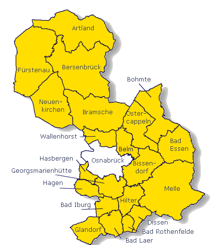
| Locations in the District OSNABRUECK (Source: Wikipedia) |
||||||||||||


| The following Municipal Register contains all places of the "Geschichtlichen Orts-Verzeichnisses" (GOV) of CompGen in OSNABRÐCK. By activating the individual buttons in the four columns >Topo<, >SLUB<, >GOV< and >Meyers<, the geographical location of a place can be called up on a map from the geographical OpenTopoMap and Kartenforum or the place descriptions in the GOV-Ortsverzeichnis and Meyers Gazetteer. | ||||||||||||||||||||||||||
| A | B | C | D | E | F | G | H | I | J | K | L | M | N | O | P | Q | R | S | T | U | V | W | X | Y | Z | |
| Community | District | Location Type | GOV | Meyers | Parts of a Community | Type | Coordinates | Topo | WikiM | SLUB | GOV |
| Alfhausen | Osnabr¸ck | Community |  |
 |
St. Johannis (Alfhausen) | Municipality | 52.5002 N 007.9526 E |  |
 |
 |
|
| Ankum | Osnabr¸ck | Community | |
|
Ankum (St. Nikolaus) | Municipality | 52.5428 N 007.8700 E | |
|
|
|
| Community | District | Location Type | GOV | Meyers | Parts of a Community | Type | Coordinates | Topo | WikiM | SLUB | GOV |
| Bad Essen | Osnabr¸ck | Community | |
|
Bad Essen (Mari‰ Himmelfahrt) | Municipality | 52.3192 N 008.3473 E | |
|
|
|
| Marien-Kirche/ Rabber | Municipality | |
|||||||||
| Bad Iburg | Osnabr¸ck | Town | |
|
Bad Iburg (St. Clemens) | City | 52.1577 N 008.0424 E | |
|
|
|
| Bad Iburg-Glane (St. Jacobus der ƒltere) | City | 52.1469 N 008.0531 E | |
|
|
|
|||||
| Bad Laer | Osnabr¸ck | Community | |
|
Mari‰ Geburt (Bad Laer) | Municipality | 52.1025 N 008.0892 E | |
|
|
|
| Bad Laer-Remsede (St. Antonius Abt) | Municipality | 52.1296 N 008.1057 E | |
|
|
|
|||||
| Bad Rothenfelde | Osnabr¸ck | Community | |
|
Bad Rothenfelde (St. Elisabeth) | Municipality | 52.1092 N 008.1685 E | |
|
|
|
| Badbergen | Osnabr¸ck | Community | |
|
Badbergen (Unbefleckte Empf‰ngnis Mariens) | Municipality | 52.6337 N 007.9799 E | |
|
|
|
| Belm | Osnabr¸ck | Community | |
|
Belm-Icker (Schmerzhafte Mutter) | Municipality | 52.3388 N 008.1152 E | |
|
|
|
| Belm (St. Josef) | Municipality | 52.3015 N 008.1188 E | |
|
|
|
Belm (St. Dionysius) | Municipality | 52.3024 N 008.1403 E | |
|
|
|
| Berge | Osnabr¸ck | Community | |
|
Berge (St. Servatius) | Municipality | 52.6213 N 007.7434 E | |
|
|
|
| Berge-Grafeld (Herz Jesu) | Municipality | 52.6251 N 007.6753 E | |
|
|
|
|||||
| Bersenbr¸ck | Osnabr¸ck | Town | |
|
Bersenbr¸ck (St. Vincentius) | City | 52.5551 N 007.9503 E | |
|
|
|
| Bissendorf | Osnabr¸ck | Community | |
|
Bissendorf (St. Dionysius) | Municipality | 52.2357 N 008.1703 E | |
|
|
|
| Bissendorf-Schledehausen (St. Laurentius) | Municipality | 52.2820 N 008.2407 E | |
|
|
|
|||||
| Bohmte | Osnabr¸ck | Community | |
|
Bohmte (St. Johannes der T‰ufer-Enthauptung) | Municipality | 52.3674 N 008.3127 E | |
|
|
|
| Bohmte-Hunteburg (Dreifaltigkeit) | Municipality | 52.4401 N 008.2754 E | |
|
|
|
|||||
| Bramsche | Osnabr¸ck | Town | |
|
Bramsche (St. Martinus) | City | 52.4142 N 007.9772 E | |
|
|
|
| Community | District | Location Type | GOV | Meyers | Parts of a Community | Type | Coordinates | Topo | WikiM | SLUB | GOV |
| Eggerm¸hlen | Osnabr¸ck | Community | |
|
Eggerm¸hlen (Mari‰ Himmelfahrt) | Municipality | 52.5668 N 007.8154 E | |
|
|
|
| Community | District | Location Type | GOV | Meyers | Parts of a Community | Type | Coordinates | Topo | WikiM | SLUB | GOV |
| F¸rstenau | Osnabr¸ck | Town | |
|
F¸rstenau (St. Katharina) | City | 52.5160 N 007.6729 E | |
|
|
|
| F¸rstenau-Schwagstorf (St. Bartholom‰us) | City | 52.5186 N 007.7481 E | |
|
|
|
F¸rstenau-Hollenstede (Maria Rosenkranz) | City | 52.4924 N 007.6813 E | |
|
|
|
| Community | District | Location Type | GOV | Meyers | Parts of a Community | Type | Coordinates | Topo | WikiM | SLUB | GOV |
| Georgsmarienh¸tte | Osnabr¸ck | Town | |
|
Oesede (St. Peter und Paul) | City | 52.2066 N 008.0647 E | |
|
|
|
| St. Antonius von Padua (Holzhausen-Ohrbeck) | City | 52.2221 N 008.0050 E | |
|
|
|
Oesede (Heilig Geist) | City | 52.1937 N 008.0672 E | |
|
|
|
Kloster Oesede (St. Marien) | City | 52.2004 N 008.1132 E | |
|
|
|
Kloster Oesede (St. Johann) | City | 52.2009 N 008.1134 E | |
|
|
|
Georgsmarienh¸tte (Herz Jesu) | City | 52.2075 N 008.0363 E | |
|
|
|
Harderberg (Maria Frieden) | City | 52.2272 N 008.0773 E | |
|
|
|
| Glandorf | Osnabr¸ck | Community | |
|
Glandorf (St. Johannis) | Municipality | 52.0814 N 008.0027 E | |
|
|
|
| Glandorf-Schwege (Unbefleckte Empf‰ngnis Mariens) | Municipality | 52.0753 N 007.9338 E | |
|
|
|
|||||
| Community | District | Location Type | GOV | Meyers | Parts of a Community | Type | Coordinates | Topo | WikiM | SLUB | GOV |
| Hagen am Teutoburger Wald | Osnabr¸ck | Community | |
|
Hagen-Gellenbeck (Mari‰ Himmelfahrt) | Municipality | 52.1992 N 007.9402 E | |
|
|
|
| Hagen (St. Martinus) | Municipality | 52.1968 N 007.9770 E | |
|
|
|
|||||
| Hilter am Teutoburger Wald | Osnabr¸ck | Community | |
|
Hilter (St. Josef) | Municipality | 52.1361 N 008.1468 E | |
|
|
|
| Hilter-Wellendorf (St. Barbara) | Municipality | 52.1823 N 008.1411 E | |
|
|
|
Hilter-Borgloh (St. Pankratius) | Municipality | 52.1906 N 008.1848 E | |
|
|
|
| Community | District | Location Type | GOV | Meyers | Parts of a Community | Type | Coordinates | Topo | WikiM | SLUB | GOV |
| Kettenkamp | Osnabr¸ck | Community | |
|
Kettenkamp (Herz Jesu) | Municipality | 52.5860 N 007.8288 E | |
|
|
|
| Community | District | Location Type | GOV | Meyers | Parts of a Community | Type | Coordinates | Topo | WikiM | SLUB | GOV |
| Melle | Osnabr¸ck | Town | |
|
Melle-Gesmold (St. Petrus) | City | 52.2105 N 008.2728 E | |
|
|
|
| Wellingholzhausen (St. Bartholom‰us) | City | 52.1585 N 008.2666 E | |
|
|
|
Melle (St. Matth‰us) | City | 52.2025 N 008.3370 E | |
|
|
|
Buer | City | |
Barkhausen | City | |
Hoyel | City | |
| Menslage | Osnabr¸ck | Community | |
|
Menslage | Municipality | |
||||
| Merzen | Osnabr¸ck | Community | |
|
Merzen (St. Lambertus) | Municipality | 52.4765 N 007.8305 E | |
|
|
|
| Community | District | Location Type | GOV | Meyers | Parts of a Community | Type | Coordinates | Topo | WikiM | SLUB | GOV |
| Neuenkirchen | Osnabr¸ck | Community | |
|
Neuenkirchen (St. Laurentius) | Municipality | 52.4189 N 007.8385 E | |
|
|
|
| Nortrup | Osnabr¸ck | Community | |
|
Nortrup (St. Aloysius) | Municipality | 52.6009 N 007.8801 E | |
|
|
|
| Community | District | Location Type | GOV | Meyers | Parts of a Community | Type | Coordinates | Topo | WikiM | SLUB | GOV |
| Ostercappeln | Osnabr¸ck | Community | |
|
St. Lambertus (Ostercappeln) | Municipality | 52.3445 N 008.2251 E | |
|
|
|
| Ostercappeln-Schwagstorf (Mari‰ Himmelfahrt) | Municipality | 52.3719 N 008.2111 E | |
|
|
|
|||||
| Community | District | Location Type | GOV | Meyers | Parts of a Community | Type | Coordinates | Topo | WikiM | SLUB | GOV |
| Quakenbr¸ck | Osnabr¸ck | Town | |
|
Quakenbr¸ck (Unbefleckte Empf‰ngnis Mariens) | City | 52.6757 N 007.9576 E | |
|
|
|
| Quakenbr¸ck-Hengelage (St. Paulus) | City | 52.6826 N 007.9473 E | |
|
|
|
|||||
| Community | District | Location Type | GOV | Meyers | Parts of a Community | Type | Coordinates | Topo | WikiM | SLUB | GOV |
| Rieste | Osnabr¸ck | Community | |
|
Lage-Rieste (St. Johannes der T‰ufer) | Municipality | 52.4970 N 008.0261 E | |
|
|
|
| Community | District | Location Type | GOV | Meyers | Parts of a Community | Type | Coordinates | Topo | WikiM | SLUB | GOV |
| Voltlage | Osnabr¸ck | Community | |
|
Voltlage (St. Katharina) | Municipality | 52.4301 N 007.7459 E | |
|
|
|
| Community | District | Location Type | GOV | Meyers | Parts of a Community | Type | Coordinates | Topo | WikiM | SLUB | GOV |
| Wallenhorst | Osnabr¸ck | Community | |
|
Wallenhorst-Rulle (St. Johannes Apostel und Evange | Municipality | 52.3357 N 008.0539 E | |
|
|
|
| Wallenhorst-Hollage (St. Josef) | Municipality | 52.3461 N 007.9744 E | |
|
|
|
Wallenhorst (St. Alexander) | Municipality | 52.3498 N 008.0155 E | |
|
|
|
|
||||||||||