|
|||||||||||
| District REMS-MURR-KREIS - Locations Register - |
|||||||||||
|
|
|
||||||||||
| District REMS-MURR-KREIS on the map of Germany (Source: Wikipedia) |
District REMS-MURR-KREIS on the map of Baden-Wuerttemberg (Source: Wikipedia) |
|||||||||||
|
||||||||||||
|
||||||||||||
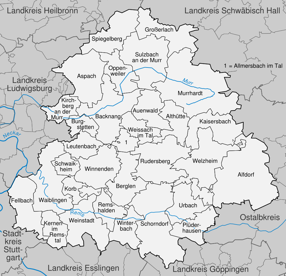
| Locations in the District REMS-MURR-KREIS (Source: Wikipedia) |
||||||||||||


| The following Ortsregister contains all places of the "Geschichtlichen Orts-Verzeichnisses" (GOV) of CompGen in REMS-MURR-KREIS. By activating the individual buttons in the four columns >Topo<, >SLUB<, >GOV< and >Meyers<, the geographical location of a place can be called up on a map from the geographical OpenTopoMap and Kartenforum or the place descriptions in the GOV-Ortsverzeichnis and Meyers Gazetteer. | ||||||||||||||||||||||||||
| A | B | C | D | E | F | G | H | I | J | K | L | M | N | O | P | Q | R | S | T | U | V | W | X | Y | Z | |
| Location | Distict | Location Typ | Coordinates | Topo | SLUB | GOV | Meyers | Community affiliation |
| Aichelbach | Rems-Murr-Kreis | Hamlet | 48.9797 N 009.4628 E |  |
 |
 |
 |
Oppenweiler |
| Aichholzhof | Rems-Murr-Kreis | Hamlet | 48.9232 N 009.4893 E | |
|
|
|
Weissach im Tal |
| Aichstrut | Rems-Murr-Kreis | Hamlet | 48.9000 N 009.6500 E | |
|
|
|
Welzheim |
| Alfdorf | Rems-Murr-Kreis | District | 48.8500 N 009.7200 E | |
|
|
|
Alfdorf |
| Allmersbach am Weinberg | Rems-Murr-Kreis | District | 48.9928 N 009.3945 E | |
|
|
|
Aspach |
| Allmersbach am Weinberg | Rems-Murr-Kreis | District | |
|
Aspach | |||
| Allmersbach im Tal | Rems-Murr-Kreis | District | 48.9068 N 009.4678 E | |
|
|
|
Allmersbach im Tal |
| Alm | Rems-Murr-Kreis | District | 48.9772 N 009.6045 E | |
|
|
|
Murrhardt |
| Altersberg | Rems-Murr-Kreis | District | 49.0142 N 009.3715 E | |
|
|
|
Aspach |
| Altf�rstenh�tte | Rems-Murr-Kreis | Hamlet | 49.0702 N 009.5073 E | |
|
|
|
Gro�erlach |
| Alth�tte | Rems-Murr-Kreis | District | 48.9124 N 009.5756 E | |
|
|
|
Alth�tte |
| Am Waldsee | Rems-Murr-Kreis | Houses | 48.9777 N 009.6639 E | |
|
|
|
Murrhardt |
| Asperglen | Rems-Murr-Kreis | Locality | 48.8500 N 009.5200 E | |
|
|
|
Rudersberg |
| Location | Distict | Location Typ | Coordinates | Topo | SLUB | GOV | Meyers | Community affiliation |
| Baach | Rems-Murr-Kreis | City Subdistrict | 48.8700 N 009.4300 E | |
|
|
|
Winnenden |
| Baach | Rems-Murr-Kreis | Hamlet | 48.7600 N 009.4200 E | |
|
|
|
Weinstadt |
| Bartenbach | Rems-Murr-Kreis | Hamlet | 48.9967 N 009.5339 E | |
|
|
|
Sulzbach an der Murr |
| Beilsbach | Rems-Murr-Kreis | Houses | 48.9817 N 009.6392 E | |
|
|
|
Murrhardt |
| Beinstein | Rems-Murr-Kreis | City Subdistrict | 48.8200 N 009.3300 E | |
|
|
|
Waiblingen |
| Bergh�fle | Rems-Murr-Kreis | Farmstead | 48.9599 N 009.6126 E | |
|
|
|
Murrhardt |
| Bernhalden | Rems-Murr-Kreis | Hamlet | 49.0209 N 009.4565 E | |
|
|
|
Oppenweiler |
| Berwinkel | Rems-Murr-Kreis | Hamlet | 49.0302 N 009.5160 E | |
|
|
|
Sulzbach an der Murr |
| Beutelsbach | Rems-Murr-Kreis | City Subdistrict | 48.8000 N 009.4000 E | |
|
|
|
Weinstadt |
| Birkachhof | Rems-Murr-Kreis | Hamlet | 48.8500 N 009.6300 E | |
|
|
|
Welzheim |
| Birkhof | Rems-Murr-Kreis | Hamlet | 48.9000 N 009.6800 E | |
|
|
|
Kaisersbach |
| Birkmannsweiler | Rems-Murr-Kreis | City Subdistrict | 48.8700 N 009.4200 E | |
|
|
|
Winnenden |
| Bittenfeld | Rems-Murr-Kreis | City Subdistrict | 48.8800 N 009.3200 E | |
|
|
|
Waiblingen |
| Blindweiler | Rems-Murr-Kreis | Deserted Settlement | 49.0024 N 009.5963 E | |
|
|
|
Murrhardt |
| B�hringsweiler | Rems-Murr-Kreis | Hamlet | 49.0731 N 009.5121 E | |
|
|
|
Gro�erlach |
| Brandh�fle | Rems-Murr-Kreis | Hamlet | 48.9300 N 009.6700 E | |
|
|
|
Kaisersbach |
| Braunhalde | Rems-Murr-Kreis | Farmstead | 48.9907 N 009.6318 E | |
|
|
|
Murrhardt |
| Breitenf�rst | Rems-Murr-Kreis | Hamlet | 48.8700 N 009.6300 E | |
|
|
|
Welzheim |
| Bretzenacker | Rems-Murr-Kreis | District | 48.8500 N 009.4500 E | |
|
|
|
Berglen |
| Breuningsweiler | Rems-Murr-Kreis | City Subdistrict | 48.8500 N 009.4000 E | |
|
|
|
Winnenden |
| Bruch | Rems-Murr-Kreis | District | 48.9214 N 009.5194 E | |
|
|
|
Weissach im Tal |
| Bruch | Rems-Murr-Kreis | Hamlet | 48.9429 N 009.6368 E | |
|
|
|
Kaisersbach |
| Bruckhof | Rems-Murr-Kreis | Hamlet | 48.9000 N 009.7000 E | |
|
|
|
Alfdorf |
| Buchenbachhof | Rems-Murr-Kreis | Farmstead | 48.8611 N 009.4412 E | |
|
|
|
Winnenden |
| Buhlbronn | Rems-Murr-Kreis | City Subdistrict | 48.8448 N 009.5180 E | |
|
|
|
Schorndorf |
| Buoch | Rems-Murr-Kreis | District | 48.8300 N 009.4200 E | |
|
|
|
Remshalden |
| B�rg | Rems-Murr-Kreis | City Subdistrict | 48.8700 N 009.4300 E | |
|
|
|
Winnenden |
| Burg Reichenberg | Rems-Murr-Kreis | Castle | 48.9915 N 009.4605 E | |
|
|
|
Oppenweiler |
| Burg Waldenstein | Rems-Murr-Kreis | Castle | 48.8907 N 009.5555 E | |
|
|
|
Rudersberg |
| Burgh�fle | Rems-Murr-Kreis | Farmstead | 48.9608 N 009.6136 E | |
|
|
|
Rudersberg |
| Burgstall | Rems-Murr-Kreis | District | 48.9267 N 009.3745 E | |
|
|
|
Burgstetten |
| Burgstall | Rems-Murr-Kreis | District | |
|
Burgstetten | |||
| Bushof | Rems-Murr-Kreis | Hamlet | 49.0243 N 009.5355 E | |
|
|
|
Sulzbach an der Murr |
| Butzberg | Rems-Murr-Kreis | Building | 49.0287 N 009.5950 E | |
|
|
|
Gro�erlach |
| Location | Distict | Location Typ | Coordinates | Topo | SLUB | GOV | Meyers | Community affiliation |
| Charlottenhof | Rems-Murr-Kreis | Deserted Settlement | 48.9909 N 009.4409 E | |
|
|
|
Oppenweiler |
| Cottenweiler | Rems-Murr-Kreis | District | 48.9182 N 009.4854 E | |
|
|
|
Weissach im Tal |
| Cronh�tte | Rems-Murr-Kreis | Hamlet | 48.9200 N 009.6800 E | |
|
|
|
Kaisersbach |
| Location | Distict | Location Typ | Coordinates | Topo | SLUB | GOV | Meyers | Community affiliation |
| D�fern | Rems-Murr-Kreis | Hamlet | 48.9274 N 009.5352 E | |
|
|
|
Auenwald |
| Dauernberg | Rems-Murr-Kreis | District | 49.0300 N 009.4607 E | |
|
|
|
Spiegelberg |
| Deschenhof | Rems-Murr-Kreis | Hamlet | 48.9000 N 009.7100 E | |
|
|
|
Alfdorf |
| Dornhalden | Rems-Murr-Kreis | Houses | 48.8700 N 009.7300 E | |
|
|
|
Alfdorf |
| Location | Distict | Location Typ | Coordinates | Topo | SLUB | GOV | Meyers | Community affiliation |
| Ebene | Rems-Murr-Kreis | Farmstead | 49.0121 N 009.5922 E | |
|
|
|
Murrhardt |
| Eberhardsweiler | Rems-Murr-Kreis | Hamlet | 48.8800 N 009.6500 E | |
|
|
|
Welzheim |
| Ebersberg | Rems-Murr-Kreis | District | 48.9376 N 009.5262 E | |
|
|
|
Auenwald |
| Ebersberg | Rems-Murr-Kreis | Hamlet | 48.9200 N 009.6700 E | |
|
|
|
Kaisersbach |
| Ebni | Rems-Murr-Kreis | Hamlet | 48.9220 N 009.5990 E | |
|
|
|
Kaisersbach |
| Ebni | Rems-Murr-Kreis | Houses | |
|
Backnang | |||
| Ebnisee | Rems-Murr-Kreis | Residential Area | 48.9200 N 009.6200 E | |
|
|
|
Kaisersbach |
| Eckartsweiler | Rems-Murr-Kreis | Hamlet | 48.9000 N 009.6300 E | |
|
|
|
Welzheim |
| Eckartsweiler S�gm�hle | Rems-Murr-Kreis | Building | 48.9021 N 009.6123 E | |
|
|
|
Welzheim |
| Ein�d | Rems-Murr-Kreis | District | 49.0001 N 009.3618 E | |
|
|
|
Aspach |
| Eisenlautern | Rems-Murr-Kreis | Hamlet | 49.0480 N 009.4430 E | |
|
|
|
Spiegelberg |
| Eisenschmiedm�hle | Rems-Murr-Kreis | Building | 48.9706 N 009.6326 E | |
|
|
|
Murrhardt |
| Ellenweiler | Rems-Murr-Kreis | Hamlet | 48.9970 N 009.4748 E | |
|
|
|
Oppenweiler |
| Endersbach | Rems-Murr-Kreis | City Subdistrict | 48.8000 N 009.3500 E | |
|
|
|
Weinstadt |
| Erbachhof | Rems-Murr-Kreis | Hamlet | 48.8610 N 009.3470 E | |
|
|
|
Waiblingen |
| Erbstetten | Rems-Murr-Kreis | District | 48.9273 N 009.3905 E | |
|
|
|
Burgstetten |
| Erbstetten | Rems-Murr-Kreis | District | |
|
Burgstetten | |||
| Erlach | Rems-Murr-Kreis | Houses | 49.0424 N 009.5334 E | |
|
|
|
Gro�erlach |
| Eschelhof | Rems-Murr-Kreis | Hamlet | 48.9776 N 009.5104 E | |
|
|
|
Sulzbach an der Murr |
| Eschenstruet | Rems-Murr-Kreis | Hamlet | 49.0256 N 009.5403 E | |
|
|
|
Sulzbach an der Murr |
| Eselshalden | Rems-Murr-Kreis | Hamlet | 48.8500 N 009.6000 E | |
|
|
|
Welzheim |
| Eulenhof | Rems-Murr-Kreis | Hamlet | 48.9200 N 009.6200 E | |
|
|
|
Kaisersbach |
| Eulenhof | Rems-Murr-Kreis | Deserted Settlement | 48.7914 N 009.3559 E | |
|
|
|
Kernen im Remstal |
| Eulenh�fle | Rems-Murr-Kreis | Hamlet | 48.9724 N 009.5712 E | |
|
|
|
Murrhardt |
| Location | Distict | Location Typ | Coordinates | Topo | SLUB | GOV | Meyers | Community affiliation |
| Fautspach | Rems-Murr-Kreis | District | 48.9471 N 009.5736 E | |
|
|
|
Alth�tte |
| Fellbach-�ffingen | Rems-Murr-Kreis | Residential Area | 48.8300 N 009.2700 E | |
|
|
|
Fellbach |
| Fellbach-�ffingen | Rems-Murr-Kreis | City Subdistrict | |
|
Fellbach | |||
| Fornsbach | Rems-Murr-Kreis | City Subdistrict | 48.9771 N 009.6489 E | |
|
|
|
Murrhardt |
| Frankenweiler | Rems-Murr-Kreis | Hamlet | 49.0217 N 009.5594 E | |
|
|
|
Gro�erlach |
| Fratzenklingenhof | Rems-Murr-Kreis | Farmstead | 48.9200 N 009.5900 E | |
|
|
|
Kaisersbach |
| Fratzenwiesenhof | Rems-Murr-Kreis | Farmstead | 48.9200 N 009.5900 E | |
|
|
|
Kaisersbach |
| Fr�hme�hof | Rems-Murr-Kreis | Hamlet | 48.9646 N 009.3538 E | |
|
|
|
Kirchberg an der Murr |
| F�rstenhof | Rems-Murr-Kreis | District | 48.9651 N 009.3806 E | |
|
|
|
Aspach |
| Location | Distict | Location Typ | Coordinates | Topo | SLUB | GOV | Meyers | Community affiliation |
| Gadeb�hl | Rems-Murr-Kreis | Place | |
|
Murrhardt | |||
| Gaisb�hl | Rems-Murr-Kreis | Hamlet | 48.9895 N 009.5574 E | |
|
|
|
Murrhardt |
| Gaisburg | Rems-Murr-Kreis | City Subdistrict | |
|
Fellbach | |||
| Gallengrotten | Rems-Murr-Kreis | Residential Area | 48.9300 N 009.6000 E | |
|
|
|
Kaisersbach |
| Gallenhof | Rems-Murr-Kreis | Hamlet | 48.9453 N 009.5555 E | |
|
|
|
Alth�tte |
| Gallenh�fle | Rems-Murr-Kreis | Farmstead | 48.9200 N 009.6000 E | |
|
|
|
Kaisersbach |
| G�nshof | Rems-Murr-Kreis | Hamlet | 48.9537 N 009.6561 E | |
|
|
|
Murrhardt |
| G�rtnershof | Rems-Murr-Kreis | Hamlet | 48.9518 N 009.6593 E | |
|
|
|
Murrhardt |
| Gausmannsweiler | Rems-Murr-Kreis | Hamlet | 48.9200 N 009.6200 E | |
|
|
|
Welzheim |
| Gausmannsweiler S�gm�hle | Rems-Murr-Kreis | Building | 48.9176 N 009.6106 E | |
|
|
|
Welzheim |
| Gebenweiler | Rems-Murr-Kreis | Hamlet | 48.9100 N 009.6500 E | |
|
|
|
Kaisersbach |
| Gebenweiler S�gm�hle | Rems-Murr-Kreis | Residential Area | 48.9000 N 009.6500 E | |
|
|
|
Kaisersbach |
| Gebenweiler-Gehren | Rems-Murr-Kreis | Hamlet | 48.9100 N 009.6600 E | |
|
|
|
Kaisersbach |
| Geradstetten | Rems-Murr-Kreis | District | 48.8000 N 009.4300 E | |
|
|
|
Remshalden |
| Germannsweiler | Rems-Murr-Kreis | Hamlet | 48.9352 N 009.4148 E | |
|
|
|
Backnang |
| Gieshof | Rems-Murr-Kreis | Houses | 49.0480 N 009.4438 E | |
|
|
|
Spiegelberg |
| Glaitenhof | Rems-Murr-Kreis | Farmstead | 48.9412 N 009.5379 E | |
|
|
|
Alth�tte |
| Gmachreich | Rems-Murr-Kreis | Hamlet | 49.0530 N 009.4973 E | |
|
|
|
Gro�erlach |
| Gmeinweiler | Rems-Murr-Kreis | Hamlet | 48.9000 N 009.6500 E | |
|
|
|
Kaisersbach |
| G�ckelhof | Rems-Murr-Kreis | Hamlet | 48.9643 N 009.6429 E | |
|
|
|
Murrhardt |
| Gollenhof | Rems-Murr-Kreis | Hamlet | 48.9031 N 009.3628 E | |
|
|
|
Leutenbach |
| Grab | Rems-Murr-Kreis | District | 49.0378 N 009.5785 E | |
|
|
|
Gro�erlach |
| Grab | Rems-Murr-Kreis | District | |
|
Gro�erlach | |||
| Grairich | Rems-Murr-Kreis | Residential Area | 48.9100 N 009.6500 E | |
|
|
|
Kaisersbach |
| Grasgehren | Rems-Murr-Kreis | Hamlet | 48.9100 N 009.5900 E | |
|
|
|
Kaisersbach |
| Greuthof | Rems-Murr-Kreis | Farmstead | 48.8600 N 009.7200 E | |
|
|
|
Alfdorf |
| Greuth�fle | Rems-Murr-Kreis | Farmstead | 48.8900 N 009.7100 E | |
|
|
|
Alfdorf |
| Gronbachm�hle | Rems-Murr-Kreis | Building | 49.0006 N 009.5162 E | |
|
|
|
Sulzbach an der Murr |
| Gro�aspach | Rems-Murr-Kreis | District | |
|
Aspach | |||
| Gro�aspach | Rems-Murr-Kreis | District | 48.9663 N 009.3970 E | |
|
|
|
Aspach |
| Gro�erlach | Rems-Murr-Kreis | Village | 49.0534 N 009.5150 E | |
|
|
|
Gro�erlach |
| Gro�heppach | Rems-Murr-Kreis | City Subdistrict | 48.8200 N 009.3800 E | |
|
|
|
Weinstadt |
| Gro�h�chberg | Rems-Murr-Kreis | District | 49.0490 N 009.4692 E | |
|
|
|
Spiegelberg |
| Grunbach | Rems-Murr-Kreis | District | 48.8200 N 009.4200 E | |
|
|
|
Remshalden |
| Gutmachhof | Rems-Murr-Kreis | Farmstead | 49.0245 N 009.5852 E | |
|
|
|
Murrhardt |
| Location | Distict | Location Typ | Coordinates | Topo | SLUB | GOV | Meyers | Community affiliation |
| Hafental | Rems-Murr-Kreis | Farmstead | 48.8900 N 009.7300 E | |
|
|
|
Alfdorf |
| Hager | Rems-Murr-Kreis | Hamlet | 49.0210 N 009.5412 E | |
|
|
|
Sulzbach an der Murr |
| H�gerhof | Rems-Murr-Kreis | Hamlet | 48.9000 N 009.5900 E | |
|
|
|
Kaisersbach |
| Hahnenhof | Rems-Murr-Kreis | Residential Area | 48.9101 N 009.5262 E | |
|
|
|
Alth�tte |
| Hals | Rems-Murr-Kreis | Hamlet | 49.0741 N 009.5052 E | |
|
|
|
Gro�erlach |
| Hammer | Rems-Murr-Kreis | Building | 49.0207 N 009.4595 E | |
|
|
|
Sulzbach an der Murr |
| Hammerschmiede | Rems-Murr-Kreis | Houses | 48.9640 N 009.6342 E | |
|
|
|
Murrhardt |
| Hangweide | Rems-Murr-Kreis | Houses | 48.8038 N 009.3307 E | |
|
|
|
Kernen im Remstal |
| Hanweiler | Rems-Murr-Kreis | City Subdistrict | 48.8541 N 009.3879 E | |
|
|
|
Winnenden |
| Harbach | Rems-Murr-Kreis | District | 48.9901 N 009.5544 E | |
|
|
|
Murrhardt |
| Hardthof | Rems-Murr-Kreis | Deserted Settlement | 48.7951 N 009.3257 E | |
|
|
|
Kernen im Remstal |
| Harrenberg | Rems-Murr-Kreis | Hamlet | 49.0048 N 009.5474 E | |
|
|
|
Sulzbach an der Murr |
| Hart | Rems-Murr-Kreis | Deserted Settlement | 48.7951 N 009.3257 E | |
|
|
|
Kernen im Remstal |
| Haselbachm�hle | Rems-Murr-Kreis | Building | 49.0100 N 009.5300 E | |
|
|
|
Sulzbach an der Murr |
| Hasenhof | Rems-Murr-Kreis | Hamlet | 48.9840 N 009.5498 E | |
|
|
|
Murrhardt |
| Haubersbronn | Rems-Murr-Kreis | City Subdistrict | 48.8300 N 009.5500 E | |
|
|
|
Schorndorf |
| Hausen an der Murr | Rems-Murr-Kreis | District | 48.9736 N 009.6164 E | |
|
|
|
Murrhardt |
| Hebsack | Rems-Murr-Kreis | District | 48.8000 N 009.4500 E | |
|
|
|
Remshalden |
| Hegnach | Rems-Murr-Kreis | City Subdistrict | 48.8500 N 009.3000 E | |
|
|
|
Waiblingen |
| Heidenhof | Rems-Murr-Kreis | Hamlet | 48.9120 N 009.3818 E | |
|
|
|
Leutenbach |
| Heiningen | Rems-Murr-Kreis | City Subdistrict | |
|
Backnang | |||
| Heiningen | Rems-Murr-Kreis | City Subdistrict | 48.9205 N 009.4428 E | |
|
|
|
Backnang |
| Heinlesm�hle | Rems-Murr-Kreis | Building | 48.9000 N 009.7000 E | |
|
|
|
Alfdorf |
| Hertmannsweiler | Rems-Murr-Kreis | City Subdistrict | 48.8890 N 009.4237 E | |
|
|
|
Winnenden |
| Heslachhof | Rems-Murr-Kreis | Hamlet | 48.9559 N 009.5174 E | |
|
|
|
Auenwald |
| Heumaden | Rems-Murr-Kreis | City Subdistrict | |
|
Fellbach | |||
| Heutensbach | Rems-Murr-Kreis | District | 48.9081 N 009.4853 E | |
|
|
|
Allmersbach im Tal |
| Hezelsberg | Rems-Murr-Kreis | Deserted Settlement | 48.9900 N 009.3400 E | |
|
|
|
Aspach |
| Hinterb�chelberg | Rems-Murr-Kreis | District | 48.9961 N 009.6284 E | |
|
|
|
Murrhardt |
| Hintermurrh�rle | Rems-Murr-Kreis | District | 49.0025 N 009.5659 E | |
|
|
|
Murrhardt |
| Hintersteinenberg | Rems-Murr-Kreis | Village | 48.8800 N 009.7200 E | |
|
|
|
Alfdorf |
| Hinterv�hrenberg | Rems-Murr-Kreis | District | 49.0038 N 009.3718 E | |
|
|
|
Aspach |
| Hinterwestermurr | Rems-Murr-Kreis | District | 48.9455 N 009.5980 E | |
|
|
|
Murrhardt |
| Hirschkeller | Rems-Murr-Kreis | Building | 48.9755 N 009.5965 E | |
|
|
|
Murrhardt |
| Hirschlauf | Rems-Murr-Kreis | District | 48.8500 N 009.3200 E | |
|
|
|
Waiblingen |
| Hirschs�gwerk | Rems-Murr-Kreis | Building | 48.9758 N 009.5997 E | |
|
|
|
Murrhardt |
| Hofen | Rems-Murr-Kreis | City Subdistrict | |
|
Fellbach | |||
| H�fen | Rems-Murr-Kreis | City Subdistrict | 48.8742 N 009.4231 E | |
|
|
|
Winnenden |
| H�fen�ckerle | Rems-Murr-Kreis | Houses | 48.9300 N 009.6000 E | |
|
|
|
Kaisersbach |
| Hoffeld | Rems-Murr-Kreis | District | 48.9907 N 009.5716 E | |
|
|
|
Murrhardt |
| Hohenacker | Rems-Murr-Kreis | City Subdistrict | 48.8700 N 009.3200 E | |
|
|
|
Waiblingen |
| Hohenbrach | Rems-Murr-Kreis | Hamlet | 49.0351 N 009.5588 E | |
|
|
|
Gro�erlach |
| Hohenstein | Rems-Murr-Kreis | Houses | 48.9872 N 009.5788 E | |
|
|
|
Murrhardt |
| Hohnweiler | Rems-Murr-Kreis | Hamlet | 48.9298 N 009.5222 E | |
|
|
|
Auenwald |
| Hohrot | Rems-Murr-Kreis | District | 48.9751 N 009.4015 E | |
|
|
|
Aspach |
| Holzbuckel | Rems-Murr-Kreis | Deserted Settlement | 48.9100 N 009.6000 E | |
|
|
|
Kaisersbach |
| Horbach | Rems-Murr-Kreis | Hamlet | 48.9077 N 009.4454 E | |
|
|
|
Backnang |
| H�rdter M�hle | Rems-Murr-Kreis | Farmstead | 49.0147 N 009.5759 E | |
|
|
|
Murrhardt |
| H�rdthof | Rems-Murr-Kreis | District | 49.0166 N 009.5710 E | |
|
|
|
Murrhardt |
| Hornungshof | Rems-Murr-Kreis | District | 48.9953 N 009.3474 E | |
|
|
|
Aspach |
| H�rschhof | Rems-Murr-Kreis | District | 48.9530 N 009.5530 E | |
|
|
|
Alth�tte |
| H�rschh�fer S�gm�hle | Rems-Murr-Kreis | Building | 48.9553 N 009.5553 E | |
|
|
|
Alth�tte |
| H��linswart | Rems-Murr-Kreis | District | 48.8300 N 009.4500 E | |
|
|
|
Berglen |
| H�ttenb�hl | Rems-Murr-Kreis | Hamlet | 48.8800 N 009.7000 E | |
|
|
|
Alfdorf |
| H�ttlen | Rems-Murr-Kreis | Hamlet | 49.0375 N 009.4374 E | |
|
|
|
Spiegelberg |
| Location | Distict | Location Typ | Coordinates | Topo | SLUB | GOV | Meyers | Community affiliation |
| Innere Fischbachs�gm�hle | Rems-Murr-Kreis | Place | 49.0000 N 009.4900 E | |
|
|
|
Sulzbach an der Murr |
| Ittenberg | Rems-Murr-Kreis | Hamlet | 48.9870 N 009.5071 E | |
|
|
|
Sulzbach an der Murr |
| Location | Distict | Location Typ | Coordinates | Topo | SLUB | GOV | Meyers | Community affiliation |
| J�gerhof | Rems-Murr-Kreis | Houses | 48.9890 N 009.6070 E | |
|
|
|
Murrhardt |
| Jux | Rems-Murr-Kreis | District | 49.0302 N 009.4385 E | |
|
|
|
Spiegelberg |
| Location | Distict | Location Typ | Coordinates | Topo | SLUB | GOV | Meyers | Community affiliation |
| Kaisersbach | Rems-Murr-Kreis | District | 48.9300 N 009.6300 E | |
|
|
|
Kaisersbach |
| Kallenberg | Rems-Murr-Kreis | District | 48.9077 N 009.5334 E | |
|
|
|
Alth�tte |
| Kaltenbronnhof | Rems-Murr-Kreis | Houses | 48.9100 N 009.6000 E | |
|
|
|
Kaisersbach |
| Kaltental | Rems-Murr-Kreis | City Subdistrict | |
|
Fellbach | |||
| Kammerhof | Rems-Murr-Kreis | Hamlet | 48.9228 N 009.5113 E | |
|
|
|
Weissach im Tal |
| Kapf | Rems-Murr-Kreis | Village | 48.8700 N 009.7200 E | |
|
|
|
Alfdorf |
| Karlshof | Rems-Murr-Kreis | District | 48.9771 N 009.3724 E | |
|
|
|
Aspach |
| Karnsberg | Rems-Murr-Kreis | District | 48.9893 N 009.6118 E | |
|
|
|
Murrhardt |
| K�sbach | Rems-Murr-Kreis | District | 48.9592 N 009.5950 E | |
|
|
|
Murrhardt |
| Katharinenhof | Rems-Murr-Kreis | Residential Area | 48.9800 N 009.4419 E | |
|
|
|
Backnang |
| Kellerklingh�fle | Rems-Murr-Kreis | Farms | 48.8900 N 009.5900 E | |
|
|
|
Kaisersbach |
| Kieselhof | Rems-Murr-Kreis | District | 49.0075 N 009.5614 E | |
|
|
|
Murrhardt |
| Killenhof | Rems-Murr-Kreis | Hamlet | 48.9000 N 009.6600 E | |
|
|
|
Kaisersbach |
| Kirchberg an der Murr | Rems-Murr-Kreis | Village | 48.9429 N 009.3414 E | |
|
|
|
Kirchberg an der Murr |
| Kirchenkirnberg | Rems-Murr-Kreis | City Subdistrict | 48.9514 N 009.6831 E | |
|
|
|
Murrhardt |
| Kirschenhardthof | Rems-Murr-Kreis | District | 48.9178 N 009.3719 E | |
|
|
|
Burgstetten |
| Kleemeisterei | Rems-Murr-Kreis | Building | 48.8836 N 009.6411 E | |
|
|
|
Welzheim |
| Kleinaspach | Rems-Murr-Kreis | District | 48.9905 N 009.3614 E | |
|
|
|
Aspach |
| Kleinaspach | Rems-Murr-Kreis | District | |
|
Aspach | |||
| Kleinerlach | Rems-Murr-Kreis | Hamlet | 49.0581 N 009.5012 E | |
|
|
|
Gro�erlach |
| Kleinheppach | Rems-Murr-Kreis | District | 48.8200 N 009.3700 E | |
|
|
|
Korb |
| Kleinh�chberg | Rems-Murr-Kreis | Hamlet | 49.0327 N 009.4811 E | |
|
|
|
Sulzbach an der Murr |
| Klettenh�fle | Rems-Murr-Kreis | Farmstead | 48.9568 N 009.6140 E | |
|
|
|
Murrhardt |
| Klingen | Rems-Murr-Kreis | District | 48.9606 N 009.6216 E | |
|
|
|
Murrhardt |
| Klingenm�hle | Rems-Murr-Kreis | Building | 48.8851 N 009.6001 E | |
|
|
|
Welzheim |
| Klingenm�hlh�fle | Rems-Murr-Kreis | Farmstead | 48.8800 N 009.5900 E | |
|
|
|
Kaisersbach |
| Kl�sterle | Rems-Murr-Kreis | Residential Area | 48.9093 N 009.5784 E | |
|
|
|
Alth�tte |
| Knickenh�fle (ehem.) | Rems-Murr-Kreis | Deserted Settlement | 49.0600 N 009.5100 E | |
|
|
|
Gro�erlach |
| K�chersberg | Rems-Murr-Kreis | District | 48.9652 N 009.6144 E | |
|
|
|
Murrhardt |
| Korb, Remstal | Rems-Murr-Kreis | District | 48.8500 N 009.3700 E | |
|
|
|
Korb |
| Kottweil | Rems-Murr-Kreis | Hamlet | 48.8300 N 009.4700 E | |
|
|
|
Berglen |
| Krehwinkel | Rems-Murr-Kreis | Hamlet | 48.8500 N 009.5000 E | |
|
|
|
Rudersberg |
| Kuhnweiler | Rems-Murr-Kreis | Hamlet | 49.0737 N 009.4978 E | |
|
|
|
Gro�erlach |
| Kurzach | Rems-Murr-Kreis | District | 49.0272 N 009.3924 E | |
|
|
|
Spiegelberg |
| Location | Distict | Location Typ | Coordinates | Topo | SLUB | GOV | Meyers | Community affiliation |
| Lammwirtschaft | Rems-Murr-Kreis | Building | 48.9715 N 009.6289 E | |
|
|
|
Murrhardt |
| Langenberg | Rems-Murr-Kreis | Hamlet | 48.8700 N 009.5800 E | |
|
|
|
Welzheim |
| Laufenm�hle | Rems-Murr-Kreis | Building | 48.8818 N 009.6063 E | |
|
|
|
Welzheim |
| Lautern | Rems-Murr-Kreis | Hamlet | 49.0093 N 009.4864 E | |
|
|
|
Sulzbach an der Murr |
| Leinhalde | Rems-Murr-Kreis | Houses | 48.9000 N 009.6400 E | |
|
|
|
Welzheim |
| Lerchen�cker | Rems-Murr-Kreis | Place | 48.9634 N 009.4310 E | |
|
|
|
Aspach |
| Lettenstich | Rems-Murr-Kreis | Hamlet | 48.8800 N 009.6000 E | |
|
|
|
Welzheim |
| Leukers | Rems-Murr-Kreis | Houses | 48.9453 N 009.6863 E | |
|
|
|
Murrhardt |
| Leutenbach | Rems-Murr-Kreis | District | 48.8882 N 009.3903 E | |
|
|
|
Leutenbach |
| Leutlinsweiler | Rems-Murr-Kreis | Hamlet | 48.9060 N 009.6926 E | |
|
|
|
Alfdorf |
| Liemannsklinge | Rems-Murr-Kreis | Hamlet | 49.0318 N 009.5344 E | |
|
|
|
Sulzbach an der Murr |
| Liemersbach | Rems-Murr-Kreis | Hamlet | 49.0538 N 009.5418 E | |
|
|
|
Gro�erlach |
| Lindhalden | Rems-Murr-Kreis | Deserted Settlement | 48.7844 N 009.3509 E | |
|
|
|
Kernen im Remstal |
| Lindle | Rems-Murr-Kreis | City Subdistrict | 48.8000 N 009.2500 E | |
|
|
|
Fellbach |
| Lippoldsweiler | Rems-Murr-Kreis | District | 48.9363 N 009.5214 E | |
|
|
|
Auenwald |
| Litzenhof | Rems-Murr-Kreis | Place | 48.9600 N 009.5000 E | |
|
|
|
Auenwald |
| Lutzenberg | Rems-Murr-Kreis | District | 48.9157 N 009.5483 E | |
|
|
|
Alth�tte |
| Lutzens�gm�hle | Rems-Murr-Kreis | Hamlet | 48.9737 N 009.6049 E | |
|
|
|
Murrhardt |
| Location | Distict | Location Typ | Coordinates | Topo | SLUB | GOV | Meyers | Community affiliation |
| Maierhof | Rems-Murr-Kreis | Houses | 48.8200 N 009.7400 E | |
|
|
|
Alfdorf |
| Maierhofer S�gm�hle | Rems-Murr-Kreis | Houses | 48.8100 N 009.7300 E | |
|
|
|
Alfdorf |
| Mannenweiler | Rems-Murr-Kreis | Hamlet | 49.0216 N 009.6020 E | |
|
|
|
Gro�erlach |
| Marxenhof | Rems-Murr-Kreis | Farmstead | 48.9596 N 009.6426 E | |
|
|
|
Murrhardt |
| Maubach | Rems-Murr-Kreis | City Subdistrict | |
|
Backnang | |||
| Maubach | Rems-Murr-Kreis | City Subdistrict | 48.9248 N 009.4270 E | |
|
|
|
Backnang |
| Meierhof | Rems-Murr-Kreis | Farmstead | 48.8760 N 009.6373 E | |
|
|
|
Welzheim |
| Menzles | Rems-Murr-Kreis | Hamlet | 48.9200 N 009.6800 E | |
|
|
|
Kaisersbach |
| Menzlesm�hle | Rems-Murr-Kreis | Building | 48.9100 N 009.6900 E | |
|
|
|
Kaisersbach |
| Mettelbach | Rems-Murr-Kreis | District | 48.9559 N 009.6396 E | |
|
|
|
Murrhardt |
| Mettelberg | Rems-Murr-Kreis | District | 48.9499 N 009.6272 E | |
|
|
|
Murrhardt |
| Mettelberger S�gm�hle | Rems-Murr-Kreis | Building | 48.9495 N 009.6385 E | |
|
|
|
Murrhardt |
| Metzlinsweiler M�hle | Rems-Murr-Kreis | Building | 48.8401 N 009.5360 E | |
|
|
|
Schorndorf |
| Meuschenm�hle | Rems-Murr-Kreis | Hamlet | 48.8600 N 009.6700 E | |
|
|
|
Alfdorf |
| Miedelsbach | Rems-Murr-Kreis | City Subdistrict | 48.8434 N 009.5435 E | |
|
|
|
Schorndorf |
| Mittelbr�den | Rems-Murr-Kreis | District | 48.9463 N 009.4977 E | |
|
|
|
Auenwald |
| Mitteldresselhof | Rems-Murr-Kreis | Hamlet | 48.9414 N 009.4742 E | |
|
|
|
Weissach im Tal |
| Mittelfischbach | Rems-Murr-Kreis | Hamlet | 49.0436 N 009.4960 E | |
|
|
|
Gro�erlach |
| Mittelschlechtbach | Rems-Murr-Kreis | Hamlet | 48.8713 N 009.5312 E | |
|
|
|
Rudersberg |
| Mittelsch�ntal | Rems-Murr-Kreis | Hamlet | 48.9469 N 009.3957 E | |
|
|
|
Backnang |
| M�nchhof | Rems-Murr-Kreis | Hamlet | 48.9300 N 009.6500 E | |
|
|
|
Kaisersbach |
| M�nchsh�tte | Rems-Murr-Kreis | Building | 49.0091 N 009.4174 E | |
|
|
|
Aspach |
| Morbach | Rems-Murr-Kreis | Hamlet | 49.0319 N 009.5938 E | |
|
|
|
Gro�erlach |
| Mutzenhof | Rems-Murr-Kreis | Farmstead | 48.9553 N 009.6592 E | |
|
|
|
Murrhardt |
| Location | Distict | Location Typ | Coordinates | Topo | SLUB | GOV | Meyers | Community affiliation |
| Nassach | Rems-Murr-Kreis | District | 49.0303 N 009.4098 E | |
|
|
|
Spiegelberg |
| Nellmersbach | Rems-Murr-Kreis | District | 48.9027 N 009.4059 E | |
|
|
|
Leutenbach |
| Neuf�rstenh�tte | Rems-Murr-Kreis | Village | 49.0628 N 009.4997 E | |
|
|
|
Gro�erlach |
| Neuhaus | Rems-Murr-Kreis | Hamlet | 48.9886 N 009.6468 E | |
|
|
|
Murrhardt |
| Neuh�chberg | Rems-Murr-Kreis | Houses | 49.0362 N 009.4516 E | |
|
|
|
Spiegelberg |
| Neuhof | Rems-Murr-Kreis | Hamlet | 48.9363 N 009.3240 E | |
|
|
|
Kirchberg an der Murr |
| Neuhof | Rems-Murr-Kreis | Farmstead | 48.8500 N 009.6300 E | |
|
|
|
Welzheim |
| Neum�hle | Rems-Murr-Kreis | Building | 48.9319 N 009.3593 E | |
|
|
|
Burgstetten |
| Neusch�ntal | Rems-Murr-Kreis | Houses | 48.9366 N 009.4002 E | |
|
|
|
Backnang |
| Neustadt | Rems-Murr-Kreis | City Subdistrict | 48.8500 N 009.3200 E | |
|
|
|
Waiblingen |
| Neuwirtshaus | Rems-Murr-Kreis | Houses | 48.9000 N 009.6900 E | |
|
|
|
Alfdorf |
| Nonnenm�hle | Rems-Murr-Kreis | District | 48.9162 N 009.5849 E | |
|
|
|
Alth�tte |
| Nonnfelder Hof | Rems-Murr-Kreis | Farmstead | 50.9842 N 006.2161 E | |
|
|
|
Alth�tte |
| Location | Distict | Location Typ | Coordinates | Topo | SLUB | GOV | Meyers | Community affiliation |
| Oberberken | Rems-Murr-Kreis | City Subdistrict | 48.7768 N 009.5558 E | |
|
|
|
Schorndorf |
| Oberbr�den | Rems-Murr-Kreis | District | 48.9555 N 009.5062 E | |
|
|
|
Auenwald |
| Oberdresselhof | Rems-Murr-Kreis | Hamlet | 48.9413 N 009.4788 E | |
|
|
|
Weissach im Tal |
| Obere Ro�staig | Rems-Murr-Kreis | Hamlet | 49.0449 N 009.4373 E | |
|
|
|
Spiegelberg |
| Obere Schafscheuer | Rems-Murr-Kreis | Building | 48.9771 N 009.5998 E | |
|
|
|
Murrhardt |
| Oberm�hle | Rems-Murr-Kreis | Farmstead | 48.8827 N 009.6422 E | |
|
|
|
Welzheim |
| Oberneustetten | Rems-Murr-Kreis | District | 48.9592 N 009.6606 E | |
|
|
|
Murrhardt |
| Obersch�ntal | Rems-Murr-Kreis | Hamlet | 48.9428 N 009.4026 E | |
|
|
|
Backnang |
| Obersteinenberg | Rems-Murr-Kreis | Hamlet | 48.8700 N 009.5700 E | |
|
|
|
Welzheim |
| Obertorh�fe | Rems-Murr-Kreis | Residential Area | 48.9564 N 009.3517 E | |
|
|
|
Kirchberg an der Murr |
| Oberurbach | Rems-Murr-Kreis | District | 48.8000 N 009.5800 E | |
|
|
|
Urbach, Rems |
| Oberweissach | Rems-Murr-Kreis | District | 48.9229 N 009.5011 E | |
|
|
|
Weissach im Tal |
| �dernhardt | Rems-Murr-Kreis | District | 48.8500 N 009.4700 E | |
|
|
|
Berglen |
| Oeschelbronn | Rems-Murr-Kreis | District | 48.8800 N 009.4500 E | |
|
|
|
Berglen |
| �lm�hle | Rems-Murr-Kreis | Building | 48.8705 N 009.6452 E | |
|
|
|
Welzheim |
| Oppelsbohm | Rems-Murr-Kreis | District | 48.8500 N 009.4700 E | |
|
|
|
Berglen |
| Oppenweiler | Rems-Murr-Kreis | Village | 48.9838 N 009.4588 E | |
|
|
|
Oppenweiler |
| Location | Distict | Location Typ | Coordinates | Topo | SLUB | GOV | Meyers | Community affiliation |
| Petershaldenhof | Rems-Murr-Kreis | Place | 48.8300 N 009.6600 E | |
|
|
|
Alfdorf |
| Pfahlbronn | Rems-Murr-Kreis | District | 48.8300 N 009.6700 E | |
|
|
|
Alfdorf |
| Pfahlenhof | Rems-Murr-Kreis | Farmstead | 48.8600 N 009.7200 E | |
|
|
|
Alfdorf |
| Platte | Rems-Murr-Kreis | Houses | 49.0352 N 009.6034 E | |
|
|
|
Gro�erlach |
| Plattenwald | Rems-Murr-Kreis | Settlement | 48.9555 N 009.4529 E | |
|
|
|
Backnang |
| Pl�derhausen | Rems-Murr-Kreis | Village | 48.7900 N 009.6000 E | |
|
|
|
Pl�derhausen |
| Location | Distict | Location Typ | Coordinates | Topo | SLUB | GOV | Meyers | Community affiliation |
| Raith�fle | Rems-Murr-Kreis | Farmstead | 48.9649 N 009.6264 E | |
|
|
|
Murrhardt |
| Reichenbach an der Murr | Rems-Murr-Kreis | Hamlet | 48.9893 N 009.4707 E | |
|
|
|
Oppenweiler |
| Reichenbach bei Winnenden | Rems-Murr-Kreis | District | 48.8400 N 009.4400 E | |
|
|
|
Berglen |
| Reichenberg | Rems-Murr-Kreis | Village | 48.9928 N 009.4617 E | |
|
|
|
Oppenweiler |
| Rettersburg | Rems-Murr-Kreis | District | 48.8739 N 009.4717 E | |
|
|
|
Berglen |
| Reute | Rems-Murr-Kreis | Houses | 48.9498 N 009.6768 E | |
|
|
|
Murrhardt |
| Reutenhof | Rems-Murr-Kreis | Hamlet | 48.9833 N 009.4652 E | |
|
|
|
Oppenweiler |
| Rietenau | Rems-Murr-Kreis | District | |
|
Aspach | |||
| Rietenau | Rems-Murr-Kreis | District | 48.9882 N 009.4072 E | |
|
|
|
Aspach |
| Robert-Kaess-Siedlung | Rems-Murr-Kreis | Houses | 48.9504 N 009.4158 E | |
|
|
|
Backnang |
| Rohr | Rems-Murr-Kreis | City Subdistrict | |
|
Fellbach | |||
| R�hrach | Rems-Murr-Kreis | District | 48.9830 N 009.3775 E | |
|
|
|
Aspach |
| Rohracker | Rems-Murr-Kreis | City Subdistrict | |
|
Fellbach | |||
| Rohrbach | Rems-Murr-Kreis | Hamlet | 49.0009 N 009.4396 E | |
|
|
|
Oppenweiler |
| Rohrbronn | Rems-Murr-Kreis | District | 48.8136 N 009.4645 E | |
|
|
|
Remshalden |
| Rommelshausen | Rems-Murr-Kreis | District | 48.8073 N 009.3216 E | |
|
|
|
Kernen im Remstal |
| R�sersm�hle | Rems-Murr-Kreis | Hamlet | 49.0550 N 009.5599 E | |
|
|
|
Gro�erlach |
| Ro�staig | Rems-Murr-Kreis | Hamlet | 49.0426 N 009.4342 E | |
|
|
|
Spiegelberg |
| Rotbachh�fle | Rems-Murr-Kreis | Farmstead | 48.9100 N 009.6700 E | |
|
|
|
Kaisersbach |
| Rotenberg | Rems-Murr-Kreis | City Subdistrict | |
|
Fellbach | |||
| Rotenmad | Rems-Murr-Kreis | Hamlet | 48.9000 N 009.6800 E | |
|
|
|
Kaisersbach |
| R�tleshof | Rems-Murr-Kreis | Farmstead | 48.9536 N 009.4076 E | |
|
|
|
Backnang |
| Rottmannsberg | Rems-Murr-Kreis | Hamlet | 48.9502 N 009.5323 E | |
|
|
|
Auenwald |
| Rottmannsberger S�gm�hle | Rems-Murr-Kreis | Building | 48.9541 N 009.5459 E | |
|
|
|
Alth�tte |
| Rudersberg | Rems-Murr-Kreis | Main Place | 48.8800 N 009.5300 E | |
|
|
|
Rudersberg |
| R�flensm�hle | Rems-Murr-Kreis | Houses | 48.9920 N 009.4675 E | |
|
|
|
Oppenweiler |
| Ruitzenm�hle | Rems-Murr-Kreis | Building | 48.8716 N 009.4197 E | |
|
|
|
Winnenden |
| Location | Distict | Location Typ | Coordinates | Topo | SLUB | GOV | Meyers | Community affiliation |
| Sachsenweiler | Rems-Murr-Kreis | District | 48.9435 N 009.4619 E | |
|
|
|
Backnang |
| S�gb�hl | Rems-Murr-Kreis | Farmstead | 48.9200 N 009.6500 E | |
|
|
|
Kaisersbach |
| Salbengehren | Rems-Murr-Kreis | Deserted Settlement | 48.9000 N 009.6800 E | |
|
|
|
Kaisersbach |
| Sauerhof | Rems-Murr-Kreis | Farmstead | 48.9427 N 009.5322 E | |
|
|
|
Auenwald |
| Sauerh�fle | Rems-Murr-Kreis | Hamlet | 48.9582 N 009.6122 E | |
|
|
|
Murrhardt |
| Schadberg | Rems-Murr-Kreis | Hamlet | 48.9000 N 009.6800 E | |
|
|
|
Kaisersbach |
| Schafhof | Rems-Murr-Kreis | Hamlet | 48.8800 N 009.6500 E | |
|
|
|
Welzheim |
| Schelmenholz | Rems-Murr-Kreis | City Subdistrict | 48.8660 N 009.3860 E | |
|
|
|
Winnenden |
| Schiffrain | Rems-Murr-Kreis | Hamlet | 49.0043 N 009.4510 E | |
|
|
|
Oppenweiler |
| Schillinghof | Rems-Murr-Kreis | Building | 48.9000 N 009.6700 E | |
|
|
|
Welzheim |
| Schillingshof | Rems-Murr-Kreis | Hamlet | 48.9018 N 009.6871 E | |
|
|
|
Kaisersbach |
| Schlechtbach | Rems-Murr-Kreis | Locality | 48.8700 N 009.5200 E | |
|
|
|
Rudersberg |
| Schlei�weiler | Rems-Murr-Kreis | Hamlet | 48.9929 N 009.5372 E | |
|
|
|
Sulzbach an der Murr |
| Schlichenh�fle | Rems-Murr-Kreis | District | 48.9238 N 009.5736 E | |
|
|
|
Alth�tte |
| Schlichenweiler | Rems-Murr-Kreis | District | 48.9360 N 009.5469 E | |
|
|
|
Alth�tte |
| Schlichten | Rems-Murr-Kreis | City Subdistrict | 48.7719 N 009.5034 E | |
|
|
|
Schorndorf |
| Schloss Stetten | Rems-Murr-Kreis | Houses | 48.7917 N 009.3407 E | |
|
|
|
Kernen im Remstal |
| Schlosshof | Rems-Murr-Kreis | District | 48.9480 N 009.6045 E | |
|
|
|
Murrhardt |
| Schlo�h�fer S�gm�hle | Rems-Murr-Kreis | Building | 48.9493 N 009.5995 E | |
|
|
|
Murrhardt |
| Schlo�m�hle | Rems-Murr-Kreis | Farmstead | 48.9518 N 009.6387 E | |
|
|
|
Murrhardt |
| Schlo�m�hle | Rems-Murr-Kreis | Residential Area | 49.0744 N 009.5120 E | |
|
|
|
Gro�erlach |
| Schmalenberg | Rems-Murr-Kreis | Farmstead | 48.8900 N 009.6000 E | |
|
|
|
Kaisersbach |
| Schmiden | Rems-Murr-Kreis | City Subdistrict | 48.8300 N 009.2700 E | |
|
|
|
Fellbach |
| Schmollenm�hle | Rems-Murr-Kreis | Houses | 48.9498 N 009.5027 E | |
|
|
|
Auenwald |
| Schnait | Rems-Murr-Kreis | City Subdistrict | 48.7899 N 009.4048 E | |
|
|
|
Weinstadt |
| Sch�lleshof | Rems-Murr-Kreis | Farmstead | 48.8235 N 009.7228 E | |
|
|
|
Alfdorf |
| Sch�llh�tte | Rems-Murr-Kreis | District | 48.9201 N 009.5760 E | |
|
|
|
Alth�tte |
| Sch�nbronn | Rems-Murr-Kreis | Hamlet | 49.0459 N 009.5883 E | |
|
|
|
Gro�erlach |
| Sch�nenb�hl | Rems-Murr-Kreis | Farmstead | 48.9865 N 009.4160 E | |
|
|
|
Aspach |
| Sch�ntalh�fle (Schertelh�fle) | Rems-Murr-Kreis | Hamlet | 49.0439 N 009.5681 E | |
|
|
|
Gro�erlach |
| Schornbach | Rems-Murr-Kreis | City Subdistrict | 48.8308 N 009.5119 E | |
|
|
|
Schorndorf |
| Schotthof | Rems-Murr-Kreis | Houses | 48.8700 N 009.7400 E | |
|
|
|
Alfdorf |
| Schulerhof | Rems-Murr-Kreis | Hamlet | 48.8700 N 009.4400 E | |
|
|
|
Winnenden |
| Schulhaus | Rems-Murr-Kreis | Building | 48.9200 N 009.4326 E | |
|
|
|
Backnang |
| Schwaikheim | Rems-Murr-Kreis | Parish Village | 48.8732 N 009.3526 E | |
|
|
|
Schwaikheim |
| Schwammhof | Rems-Murr-Kreis | Hamlet | 48.9643 N 009.5682 E | |
|
|
|
Murrhardt |
| Schwarzenm�hle | Rems-Murr-Kreis | Farmstead | 48.9779 N 009.5577 E | |
|
|
|
Murrhardt |
| Schweizerhof | Rems-Murr-Kreis | Farmstead | 49.0265 N 009.5894 E | |
|
|
|
Gro�erlach |
| Sechselberg | Rems-Murr-Kreis | District | 48.9427 N 009.5497 E | |
|
|
|
Alth�tte |
| Seehaus | Rems-Murr-Kreis | Place | 48.8900 N 009.6900 E | |
|
|
|
Alfdorf |
| Seehof | Rems-Murr-Kreis | Hamlet | 48.9603 N 009.4364 E | |
|
|
|
Backnang |
| Seem�hle | Rems-Murr-Kreis | Building | 48.9229 N 009.4830 E | |
|
|
|
Weissach im Tal |
| Seem�hle | Rems-Murr-Kreis | Houses | 48.7988 N 009.3514 E | |
|
|
|
Kernen im Remstal |
| Seiboldsweiler | Rems-Murr-Kreis | Hamlet | 48.9000 N 009.6300 E | |
|
|
|
Welzheim |
| Siebenknie | Rems-Murr-Kreis | District | 48.9781 N 009.5347 E | |
|
|
|
Murrhardt |
| Siebersbach | Rems-Murr-Kreis | Hamlet | 49.0197 N 009.4686 E | |
|
|
|
Sulzbach an der Murr |
| Siedlung Benzach | Rems-Murr-Kreis | Settlement | 48.8100 N 009.3750 E | |
|
|
|
Weinstadt |
| Siegelsberg | Rems-Murr-Kreis | District | 48.9939 N 009.5933 E | |
|
|
|
Murrhardt |
| Sinzenburg | Rems-Murr-Kreis | District | 49.0002 N 009.3460 E | |
|
|
|
Aspach |
| Sommerhaus | Rems-Murr-Kreis | Building | 49.0215 N 009.5872 E | |
|
|
|
Murrhardt |
| Sonnenberg | Rems-Murr-Kreis | Deserted Settlement | |
|
Kernen im Remstal | |||
| Spatzenhof | Rems-Murr-Kreis | Farmstead | 48.9300 N 009.6100 E | |
|
|
|
Kaisersbach |
| Spechtshof | Rems-Murr-Kreis | Hamlet | 49.0040 N 009.5812 E | |
|
|
|
Murrhardt |
| Spechtshof | Rems-Murr-Kreis | Hamlet | 48.8400 N 009.4400 E | |
|
|
|
Berglen |
| Spiegelberg | Rems-Murr-Kreis | District | 49.0385 N 009.4467 E | |
|
|
|
Spiegelberg |
| Spielhof | Rems-Murr-Kreis | Hamlet | 48.9592 N 009.6761 E | |
|
|
|
Murrhardt |
| Spinnerei | Rems-Murr-Kreis | Houses | 48.9479 N 009.4479 E | |
|
|
|
Backnang |
| Staigacker | Rems-Murr-Kreis | Farmstead | 48.9769 N 009.4481 E | |
|
|
|
Backnang |
| Stegm�hle | Rems-Murr-Kreis | District | 48.9731 N 009.4029 E | |
|
|
|
Aspach |
| Steinach b Backnang | Rems-Murr-Kreis | District | 48.8300 N 009.4500 E | |
|
|
|
Berglen |
| Steinbach | Rems-Murr-Kreis | City Subdistrict | 48.9571 N 009.4755 E | |
|
|
|
Backnang |
| Steinbach | Rems-Murr-Kreis | City Subdistrict | |
|
Backnang | |||
| Steinberg | Rems-Murr-Kreis | District | 49.0106 N 009.5839 E | |
|
|
|
Murrhardt |
| Steinbruck | Rems-Murr-Kreis | Hamlet | 48.8500 N 009.5800 E | |
|
|
|
Welzheim |
| Steinenberg | Rems-Murr-Kreis | Locality | 48.8500 N 009.5300 E | |
|
|
|
Rudersberg |
| Steinhaus | Rems-Murr-Kreis | Hamlet | 48.9000 N 009.6900 E | |
|
|
|
Alfdorf |
| Steinhausen | Rems-Murr-Kreis | District | 49.0059 N 009.3779 E | |
|
|
|
Aspach |
| Stephanienruhe | Rems-Murr-Kreis | Place | 47.9700 N 007.8300 E | |
|
|
|
Welzheim |
| Stetten im Remstal | Rems-Murr-Kreis | District | 48.7900 N 009.3414 E | |
|
|
|
Kernen im Remstal |
| Stiftsgrundhof | Rems-Murr-Kreis | Hamlet | 48.9111 N 009.4189 E | |
|
|
|
Backnang |
| Stirenhof | Rems-Murr-Kreis | Place | 48.9100 N 009.7100 E | |
|
|
|
Alfdorf |
| Stixenhof | Rems-Murr-Kreis | Hamlet | 48.8500 N 009.7200 E | |
|
|
|
Alfdorf |
| St�ckenhof | Rems-Murr-Kreis | Hamlet | 48.8900 N 009.4550 E | |
|
|
|
Berglen |
| Streitweiler | Rems-Murr-Kreis | Deserted Settlement | 48.9639 N 009.5409 E | |
|
|
|
Murrhardt |
| Strohhof | Rems-Murr-Kreis | Hamlet | 48.9000 N 009.6800 E | |
|
|
|
Kaisersbach |
| Str�bel | Rems-Murr-Kreis | Hamlet | 48.8599 N 009.7249 E | |
|
|
|
Alfdorf |
| Str�belm�hle | Rems-Murr-Kreis | Farmstead | 48.8500 N 009.7200 E | |
|
|
|
Alfdorf |
| Str�mpfelbach | Rems-Murr-Kreis | City Subdistrict | |
|
Backnang | |||
| Str�mpfelbach | Rems-Murr-Kreis | City Subdistrict | 48.7800 N 009.3600 E | |
|
|
|
Weinstadt |
| Str�mpfelbach | Rems-Murr-Kreis | City Subdistrict | 48.9725 N 009.4342 E | |
|
|
|
Backnang |
| Sulzbach an der Murr | Rems-Murr-Kreis | Village | 49.0032 N 009.5049 E | |
|
|
|
Sulzbach an der Murr |
| Location | Distict | Location Typ | Coordinates | Topo | SLUB | GOV | Meyers | Community affiliation |
| T�le | Rems-Murr-Kreis | Hamlet | 48.9200 N 009.6500 E | |
|
|
|
Kaisersbach |
| T�le | Rems-Murr-Kreis | Hamlet | 48.9639 N 009.6916 E | |
|
|
|
Murrhardt |
| Talm�hle | Rems-Murr-Kreis | District | 48.9581 N 009.3963 E | |
|
|
|
Aspach |
| Taubenhof | Rems-Murr-Kreis | Hamlet | 48.8700 N 009.6000 E | |
|
|
|
Welzheim |
| Tennhof | Rems-Murr-Kreis | Farmstead | 48.8500 N 009.2600 E | |
|
|
|
Fellbach |
| Tennh�fle | Rems-Murr-Kreis | Hamlet | 48.8600 N 009.7400 E | |
|
|
|
Alfdorf |
| Tiefenmad | Rems-Murr-Kreis | Hamlet | 48.9538 N 009.6695 E | |
|
|
|
Murrhardt |
| Tiefental | Rems-Murr-Kreis | Hamlet | 48.9678 N 009.5178 E | |
|
|
|
Auenwald |
| Trailhof | Rems-Murr-Kreis | Hamlet | 48.9635 N 009.5303 E | |
|
|
|
Auenwald |
| Trailh�fle | Rems-Murr-Kreis | Hamlet | 48.9565 N 009.5393 E | |
|
|
|
Auenwald |
| Trauzenbach | Rems-Murr-Kreis | Hamlet | 49.0252 N 009.5702 E | |
|
|
|
Gro�erlach |
| Location | Distict | Location Typ | Coordinates | Topo | SLUB | GOV | Meyers | Community affiliation |
| Uhlbach | Rems-Murr-Kreis | City Subdistrict | |
|
Fellbach | |||
| Ungeheuerhof | Rems-Murr-Kreis | Hamlet | 48.9306 N 009.4564 E | |
|
|
|
Backnang |
| Unterbr�den | Rems-Murr-Kreis | District | 48.9375 N 009.5006 E | |
|
|
|
Auenwald |
| Unterdresselhof | Rems-Murr-Kreis | Hamlet | 48.9408 N 009.4714 E | |
|
|
|
Weissach im Tal |
| Untere Schafscheuer | Rems-Murr-Kreis | Houses | 48.9831 N 009.5543 E | |
|
|
|
Murrhardt |
| Unterfischbach | Rems-Murr-Kreis | Hamlet | 49.0385 N 009.4996 E | |
|
|
|
Gro�erlach |
| Unterm�hle | Rems-Murr-Kreis | Building | 48.8772 N 009.6435 E | |
|
|
|
Welzheim |
| Unterneustetten | Rems-Murr-Kreis | District | 48.9606 N 009.6570 E | |
|
|
|
Murrhardt |
| Untersch�ntal | Rems-Murr-Kreis | Hamlet | 48.9508 N 009.3947 E | |
|
|
|
Backnang |
| Unterstaigacker | Rems-Murr-Kreis | Houses | 48.9790 N 009.4534 E | |
|
|
|
Oppenweiler |
| Unterurbach | Rems-Murr-Kreis | District | 48.8200 N 009.5800 E | |
|
|
|
Urbach, Rems |
| Unterweissach | Rems-Murr-Kreis | District | 48.9298 N 009.4784 E | |
|
|
|
Weissach im Tal |
| Utzenhof | Rems-Murr-Kreis | Hamlet | 48.9644 N 009.5068 E | |
|
|
|
Auenwald |
| Location | Distict | Location Typ | Coordinates | Topo | SLUB | GOV | Meyers | Community affiliation |
| Vaihinghof | Rems-Murr-Kreis | Farmstead | 48.9000 N 009.7000 E | |
|
|
|
Alfdorf |
| Viehhaus | Rems-Murr-Kreis | Hamlet | 48.9232 N 009.4862 E | |
|
|
|
Weissach im Tal |
| V�gelesreute | Rems-Murr-Kreis | Houses | 48.9476 N 009.6944 E | |
|
|
|
Murrhardt |
| Voggenhof | Rems-Murr-Kreis | District | 48.9193 N 009.5905 E | |
|
|
|
Alth�tte |
| Voggenm�hlh�fle | Rems-Murr-Kreis | Hamlet | 48.9000 N 009.6900 E | |
|
|
|
Kaisersbach |
| V�lkleshofen | Rems-Murr-Kreis | District | 49.0077 N 009.3607 E | |
|
|
|
Aspach |
| Vorderb�chelberg | Rems-Murr-Kreis | District | 49.0651 N 009.4559 E | |
|
|
|
Spiegelberg |
| Vorderhundsberg | Rems-Murr-Kreis | Hamlet | 48.8700 N 009.6000 E | |
|
|
|
Welzheim |
| Vordermurrh�rle | Rems-Murr-Kreis | District | 48.9998 N 009.5682 E | |
|
|
|
Murrhardt |
| Vordersteinenberg | Rems-Murr-Kreis | District | 48.8800 N 009.7200 E | |
|
|
|
Alfdorf |
| Vorderv�hrenberg | Rems-Murr-Kreis | District | 49.0026 N 009.3787 E | |
|
|
|
Aspach |
| Vorderwei�buch | Rems-Murr-Kreis | District | 48.8551 N 009.5026 E | |
|
|
|
Berglen |
| Vorderwestermurr | Rems-Murr-Kreis | District | 48.9548 N 009.5828 E | |
|
|
|
Murrhardt |
| Location | Distict | Location Typ | Coordinates | Topo | SLUB | GOV | Meyers | Community affiliation |
| Wacholderhof | Rems-Murr-Kreis | Hamlet | 49.0214 N 009.5808 E | |
|
|
|
Murrhardt |
| Wachth�usle | Rems-Murr-Kreis | Houses | 48.9926 N 009.4680 E | |
|
|
|
Oppenweiler |
| Wahlenheim | Rems-Murr-Kreis | Hamlet | 48.8800 N 009.7000 E | |
|
|
|
Alfdorf |
| Wahlenm�hle | Rems-Murr-Kreis | Building | 48.9721 N 009.6277 E | |
|
|
|
Murrhardt |
| Waldbruderhaus | Rems-Murr-Kreis | Deserted Settlement | |
|
Kernen im Remstal | |||
| Waldenstein | Rems-Murr-Kreis | Hamlet | 48.8900 N 009.5500 E | |
|
|
|
Rudersberg |
| Waldenweiler | Rems-Murr-Kreis | District | 48.9324 N 009.5604 E | |
|
|
|
Alth�tte |
| Waldrems | Rems-Murr-Kreis | City Subdistrict | |
|
Backnang | |||
| Waldrems | Rems-Murr-Kreis | City Subdistrict | 48.9156 N 009.4360 E | |
|
|
|
Backnang |
| Waltersberg | Rems-Murr-Kreis | District | 48.9665 N 009.5608 E | |
|
|
|
Murrhardt |
| Warthof | Rems-Murr-Kreis | District | 49.0190 N 009.4133 E | |
|
|
|
Aspach |
| Wasenhaus | Rems-Murr-Kreis | Residential Area | 49.0200 N 009.5600 E | |
|
|
|
Gro�erlach |
| Wattenweiler | Rems-Murr-Kreis | Hamlet | 48.9122 N 009.5025 E | |
|
|
|
Weissach im Tal |
| Weidenbach | Rems-Murr-Kreis | Hamlet | 48.9371 N 009.6263 E | |
|
|
|
Kaisersbach |
| Weidenhof | Rems-Murr-Kreis | Farmstead | 48.9376 N 009.6212 E | |
|
|
|
Kaisersbach |
| Weiler zum Stein | Rems-Murr-Kreis | District | |
|
Leutenbach | |||
| Weiler zum Stein | Rems-Murr-Kreis | District | 48.9004 N 009.3728 E | |
|
|
|
Leutenbach |
| Weiler/Rems | Rems-Murr-Kreis | City Subdistrict | 48.7975 N 009.5016 E | |
|
|
|
Schorndorf |
| Westermurrer M�hle | Rems-Murr-Kreis | Building | 48.9489 N 009.5852 E | |
|
|
|
Murrhardt |
| Westermurrer S�gm�hle | Rems-Murr-Kreis | Building | 48.9489 N 009.5852 E | |
|
|
|
Murrhardt |
| Wiedhof | Rems-Murr-Kreis | Houses | 49.0755 N 009.5140 E | |
|
|
|
Gro�erlach |
| Wiesenhof | Rems-Murr-Kreis | Houses | 48.9499 N 009.6797 E | |
|
|
|
Murrhardt |
| Wiesensteighof | Rems-Murr-Kreis | Hamlet | 48.9241 N 009.6028 E | |
|
|
|
Kaisersbach |
| Wilhelmsheim | Rems-Murr-Kreis | Houses | 49.0073 N 009.4562 E | |
|
|
|
Oppenweiler |
| Winterbach | Rems-Murr-Kreis | Village | 48.8000 N 009.4800 E | |
|
|
|
Winterbach |
| Wolkenhof | Rems-Murr-Kreis | Hamlet | 48.9864 N 009.5709 E | |
|
|
|
Murrhardt |
| W�stenbachhof | Rems-Murr-Kreis | District | 48.9705 N 009.3752 E | |
|
|
|
Aspach |
| Location | Distict | Location Typ | Coordinates | Topo | SLUB | GOV | Meyers | Community affiliation |
| Zazenhausen | Rems-Murr-Kreis | City Subdistrict | |
|
Fellbach | |||
| Zell | Rems-Murr-Kreis | Hamlet | 48.9723 N 009.4608 E | |
|
|
|
Oppenweiler |
| Ziegelh�tte | Rems-Murr-Kreis | Hamlet | 48.9200 N 009.6500 E | |
|
|
|
Kaisersbach |
| Zwerenberg | Rems-Murr-Kreis | Hamlet | 49.0119 N 009.5441 E | |
|
|
|
Sulzbach an der Murr |
| Zwingelhausen | Rems-Murr-Kreis | Hamlet | 48.9546 N 009.3662 E | |
|
|
|
Kirchberg an der Murr |
|
||||||||||