|
|||||||||||
| District REMS-MURR-KREIS - Church Register - |
|||||||||||
|
|
|
||||||||||
| District REMS-MURR-KREIS on the map of Germany (Source: Wikipedia) |
District REMS-MURR-KREIS on the map of Baden-Wuerttemberg (Source: Wikipedia) |
|||||||||||
|
||||||||||||
|
||||||||||||
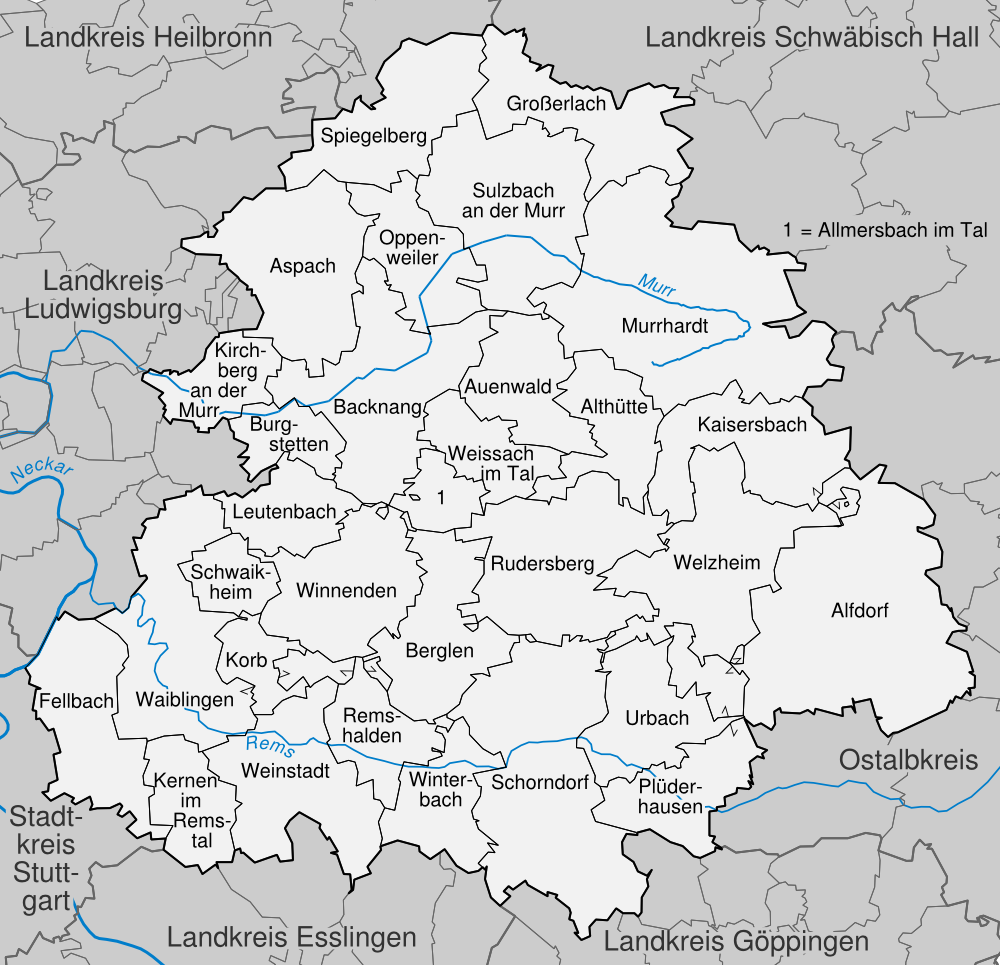
| Locations in the District REMS-MURR-KREIS (Source: Wikipedia) |
||||||||||||


| The following Municipal Register contains all places of the "Geschichtlichen Orts-Verzeichnisses" (GOV) of CompGen in REMS-MURR-KREIS. By activating the individual buttons in the four columns >Topo<, >SLUB<, >GOV< and >Meyers<, the geographical location of a place can be called up on a map from the geographical OpenTopoMap and Kartenforum or the place descriptions in the GOV-Ortsverzeichnis and Meyers Gazetteer. | ||||||||||||||||||||||||||
| A | B | C | D | E | F | G | H | I | J | K | L | M | N | O | P | Q | R | S | T | U | V | W | X | Y | Z | |
| Community | District | Location Type | GOV | Meyers | Parts of a Community | Type | Coordinates | Topo | WikiM | SLUB | GOV |
| Alfdorf | Rems-Murr-Kreis | Community |  |
 |
Alfdorf | Municipality | |
||||
| Hellershof | Municipality | 48.9064 N 009.6918 E |  |
 |
 |
|
Alfdorf (St. Clemens Maria Hofbauer) | Municipality | 48.8454 N 009.7203 E | |
|
|
|
| Aspach | Rems-Murr-Kreis | Community | |
|
Großaspach | Municipality | |
||||
| Auenwald | Rems-Murr-Kreis | Community | |
|
Ebersberg (Herz Jesu) | Municipality | 48.9356 N 009.5251 E | |
|
|
|
| Community | District | Location Type | GOV | Meyers | Parts of a Community | Type | Coordinates | Topo | WikiM | SLUB | GOV |
| Backnang | Rems-Murr-Kreis | Town | |
|
Backnang (St. Johannes Baptist) | City | 48.9442 N 009.4315 E | |
|
|
|
| Backnang (Christus König) | City | 48.9537 N 009.4415 E | |
|
|
|
|||||
| Community | District | Location Type | GOV | Meyers | Parts of a Community | Type | Coordinates | Topo | WikiM | SLUB | GOV |
| Fellbach | Rems-Murr-Kreis | Town | |
|
Fellbach (St. Johannes Evangelist) | City | 48.8095 N 009.2746 E | |
|
|
|
| Johanneskirche/Öffingen | City | 48.8458 N 009.2642 E | |
|
|
|
Schmiden (Zur Allerheiligsten Dreifaltigkeit) | City | 48.8297 N 009.2695 E | |
|
|
|
Oeffingen (Christus König) | City | 48.8417 N 009.2655 E | |
|
|
|
Dionysiuskirche/Schmiden | City | 48.8347 N 009.2639 E | |
|
|
|
| Community | District | Location Type | GOV | Meyers | Parts of a Community | Type | Coordinates | Topo | WikiM | SLUB | GOV |
| Großerlach | Rems-Murr-Kreis | Community | |
|
Grab | Municipality | |
| Community | District | Location Type | GOV | Meyers | Parts of a Community | Type | Coordinates | Topo | WikiM | SLUB | GOV |
| Kernen im Remstal | Rems-Murr-Kreis | Community | |
|
Kernen im Remstal (Heilig Kreuz) | Municipality | 48.7916 N 009.3390 E | |
|
|
|
| Kirchberg an der Murr | Rems-Murr-Kreis | Community | |
|
Kirchberg an der Murr (St. Michael) | Municipality | 48.9417 N 009.3392 E | |
|
|
|
| Korb | Rems-Murr-Kreis | Community | |
|
Korb (St. Johannes der Täufer) | Municipality | 48.8393 N 009.3555 E | |
|
|
|
| Community | District | Location Type | GOV | Meyers | Parts of a Community | Type | Coordinates | Topo | WikiM | SLUB | GOV |
| Leutenbach | Rems-Murr-Kreis | Community | |
|
Leutenbach (St. Jakobus) | Municipality | 48.8899 N 009.3929 E | |
|
|
|
| Community | District | Location Type | GOV | Meyers | Parts of a Community | Type | Coordinates | Topo | WikiM | SLUB | GOV |
| Murrhardt | Rems-Murr-Kreis | Town | |
|
Murrhardt (St. Maria) | City | 48.9797 N 009.5734 E | |
|
|
|
| Community | District | Location Type | GOV | Meyers | Parts of a Community | Type | Coordinates | Topo | WikiM | SLUB | GOV |
| Oppenweiler | Rems-Murr-Kreis | Community | |
|
Oppenweiler (St. Stephanus) | Municipality | 48.9832 N 009.4523 E | |
|
|
|
| Community | District | Location Type | GOV | Meyers | Parts of a Community | Type | Coordinates | Topo | WikiM | SLUB | GOV |
| Plüderhausen | Rems-Murr-Kreis | Community | |
|
Plüderhausen (Zum heiligsten Herzen Jesu) | Municipality | 48.7919 N 009.6062 E | |
|
|
|
| Community | District | Location Type | GOV | Meyers | Parts of a Community | Type | Coordinates | Topo | WikiM | SLUB | GOV |
| Remshalden | Rems-Murr-Kreis | Community | |
|
Remshalden (St. Michael) | Municipality | 48.8087 N 009.4161 E | |
|
|
|
| Rudersberg | Rems-Murr-Kreis | Community | |
|
Rudersberg (Zur heiligsten Dreifaltigkeit) | Municipality | 48.8829 N 009.5278 E | |
|
|
|
| Community | District | Location Type | GOV | Meyers | Parts of a Community | Type | Coordinates | Topo | WikiM | SLUB | GOV |
| Schwaikheim | Rems-Murr-Kreis | Community | |
|
Schwaikheim (St. Maria Hilfe der Christen) | Municipality | 48.8713 N 009.3477 E | |
|
|
|
| Sulzbach an der Murr | Rems-Murr-Kreis | Community | |
|
Sulzbach an der Murr (St. Paulus) | Municipality | 49.0037 N 009.5068 E | |
|
|
|
| Community | District | Location Type | GOV | Meyers | Parts of a Community | Type | Coordinates | Topo | WikiM | SLUB | GOV |
| Urbach, Rems | Rems-Murr-Kreis | Community | |
|
Urbach (St. Marien) | Municipality | 48.8114 N 009.5744 E | |
|
|
|
| Community | District | Location Type | GOV | Meyers | Parts of a Community | Type | Coordinates | Topo | WikiM | SLUB | GOV |
| Waiblingen | Rems-Murr-Kreis | Town | |
|
Waiblingen (St. Antonius) | City | 48.8321 N 009.3102 E | |
|
|
|
| Neustadt-Hohenacker (St. Maria) | City | 48.8556 N 009.3255 E | |
|
|
|
|||||
| Weinstadt | Rems-Murr-Kreis | Town | |
|
Strümpfelbach | City | |
||||
| Beutelsbach (St. Anna) | City | 48.8022 N 009.3906 E | |
|
|
|
Endersbach (St. Andreas) | City | 48.8113 N 009.3683 E | |
|
|
|
| Weissach im Tal | Rems-Murr-Kreis | Community | |
|
Weissach im Tal (Zur heiligsten Dreifaltigkeit) | Municipality | 48.9316 N 009.4728 E | |
|
|
|
| Welzheim | Rems-Murr-Kreis | Town | |
|
Welzheim (Christus König) | City | 48.8722 N 009.6349 E | |
|
|
|
| Winterbach | Rems-Murr-Kreis | Community | |
|
Winterbach (Mariä Himmelfahrt) | Municipality | 48.7963 N 009.4830 E | |
|
|
|
|
||||||||||