|
|||||||||||
| District RENDSBURG-ECKERNFųRDE - Church Register - |
|||||||||||
|
|
|
||||||||||
| District RENDSBURG-ECKERNFOERDE on the map of Germany (Source: Wikipedia) |
District RENDSBURG-ECKERNFOERDE on the map of Schleswig-Holstein (Source: Wikipedia) |
|||||||||||
|
||||||||||||
|
||||||||||||
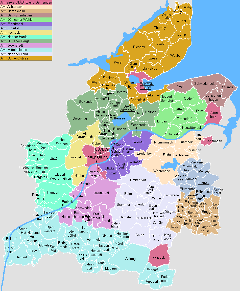
| Locations in the District RENDSBURG-ECKERNFOERDE (Source: Sonstige) |
||||||||||||


| The following Municipal Register contains all places of the "Geschichtlichen Orts-Verzeichnisses" (GOV) of CompGen in RENDSBURG-ECKERNFųRDE. By activating the individual buttons in the four columns >Topo<, >SLUB<, >GOV< and >Meyers<, the geographical location of a place can be called up on a map from the geographical OpenTopoMap and Kartenforum or the place descriptions in the GOV-Ortsverzeichnis and Meyers Gazetteer. | ||||||||||||||||||||||||||
| A | B | C | D | E | F | G | H | I | J | K | L | M | N | O | P | Q | R | S | T | U | V | W | X | Y | Z | |
| Community | District | Location Type | GOV | Meyers | Parts of a Community | Type | Coordinates | Topo | WikiM | SLUB | GOV |
| Achterwehr | Rendsburg-Eckernf÷rde | Community |  |
 |
St. Moritzkapelle/Sch÷nwohld | Municipality | 54.3027 N 010.0132 E |  |
 |
 |
|
| Achterwehr | Municipality | |
|||||||||
| Alt Duvenstedt | Rendsburg-Eckernf÷rde | Community | |
|
Matthõuskirche/Alt-Duvenstedt | Municipality | 54.3592 N 009.6446 E | |
|
|
|
| Altenholz | Rendsburg-Eckernf÷rde | Community | |
|
Eivind-Berggrav-Zentrum (EBZ) | Municipality | 54.3855 N 010.1358 E | |
|
|
|
| Aukrug | Rendsburg-Eckernf÷rde | Community | |
|
Ev. Kirche/Aukrug | Municipality | 54.0797 N 009.7854 E | |
|
|
|
| Innien | Municipality | |
|||||||||
| Community | District | Location Type | GOV | Meyers | Parts of a Community | Type | Coordinates | Topo | WikiM | SLUB | GOV |
| Barkelsby | Rendsburg-Eckernf÷rde | Community | |
|
Vers÷hnungskirche/Barkelsby | Municipality | 54.5011 N 009.8417 E | |
|
|
|
| Bordesholm | Rendsburg-Eckernf÷rde | Community | |
|
Klosterkirche/Bordesholm | Municipality | 54.1763 N 010.0114 E | |
|
|
|
| Christus-Kirche/Bordesholm | Municipality | 54.1719 N 010.0386 E | |
|
|
|
|||||
| Borgstedt | Rendsburg-Eckernf÷rde | Community | |
|
Kapelle/Borgstedt | Municipality | 54.3310 N 009.7060 E | |
|
|
|
| Bovenau | Rendsburg-Eckernf÷rde | Community | |
|
Maria-Magdalenen-Kirche/Bovenau | Municipality | 54.3305 N 009.8305 E | |
|
|
|
| Breiholz | Rendsburg-Eckernf÷rde | Community | |
|
Kreuzkirche/Breiholz | Municipality | 54.2066 N 009.5255 E | |
|
|
|
| Br³gge | Rendsburg-Eckernf÷rde | Community | |
|
St. Johannis/Br³gge | Municipality | 54.1748 N 010.0687 E | |
|
|
|
| B³delsdorf | Rendsburg-Eckernf÷rde | Town | |
|
Kreuzkirche/B³delsdorf | City | 54.3152 N 009.6616 E | |
|
|
|
| Auferstehungskirche/B³delsdorf | City | 54.3168 N 009.6878 E | |
|
|
|
|||||
| B³nsdorf | Rendsburg-Eckernf÷rde | Community | |
|
St. Katharinen-Kirche/B³nsdorf | Municipality | 54.3689 N 009.7434 E | |
|
|
|
| Community | District | Location Type | GOV | Meyers | Parts of a Community | Type | Coordinates | Topo | WikiM | SLUB | GOV |
| Dõnischenhagen | Rendsburg-Eckernf÷rde | Community | |
|
Ev. Kirche/Dõnischenhagen | Municipality | 54.4233 N 010.1266 E | |
|
|
|
| Community | District | Location Type | GOV | Meyers | Parts of a Community | Type | Coordinates | Topo | WikiM | SLUB | GOV |
| Eckernf÷rde | Rendsburg-Eckernf÷rde | Town | |
|
Ev. Kirche/Borby | City | 54.4775 N 009.8386 E | |
|
|
|
| Eckernf÷rde (St. Peter und Paul) | City | |
St. Nicolai-Kirche/Eckernf÷rde | City | 54.4719 N 009.8362 E | |
|
|
|
||
| Emkendorf | Rendsburg-Eckernf÷rde | Community | |
|
Matthias-Claudius.Kapelle/Kleinvollstedt | Municipality | 54.2425 N 009.8328 E | |
|
|
|
| Community | District | Location Type | GOV | Meyers | Parts of a Community | Type | Coordinates | Topo | WikiM | SLUB | GOV |
| Felde | Rendsburg-Eckernf÷rde | Community | |
|
Adventskapelle/Felde | Municipality | 54.2999 N 009.9387 E | |
|
|
|
| Fleckeby | Rendsburg-Eckernf÷rde | Community | |
|
Kreuzkirche/Fleckeby | Municipality | 54.4823 N 009.6908 E | |
|
|
|
| Flintbek | Rendsburg-Eckernf÷rde | Community | |
|
Ev. Kirche/Flintbek | Municipality | 54.2376 N 010.0671 E | |
|
|
|
| Fockbek | Rendsburg-Eckernf÷rde | Community | |
|
Pauluskirche/Fockbek | Municipality | 54.3061 N 009.5964 E | |
|
|
|
| Community | District | Location Type | GOV | Meyers | Parts of a Community | Type | Coordinates | Topo | WikiM | SLUB | GOV |
| Gettorf | Rendsburg-Eckernf÷rde | Community | |
|
Sankt J³rgen/Gettorf | Municipality | 54.4089 N 009.9737 E | |
|
|
|
| Gnutz | Rendsburg-Eckernf÷rde | Community | |
|
Friedenskapelle/Gnutz | Municipality | 54.1334 N 009.8176 E | |
|
|
|
| Gokels | Rendsburg-Eckernf÷rde | Community | |
|
St. Johannis-Kirche/Gokels | Municipality | 54.1127 N 009.4654 E | |
|
|
|
| Gro▀ Vollstedt | Rendsburg-Eckernf÷rde | Community | |
|
Kirche "Zum guten Hirten/Gro▀-Vollstedt | Municipality | 54.2327 N 009.8694 E | |
|
|
|
| Community | District | Location Type | GOV | Meyers | Parts of a Community | Type | Coordinates | Topo | WikiM | SLUB | GOV |
| Hamdorf | Rendsburg-Eckernf÷rde | Community | |
|
Ev. Kirche/Hamdorf | Municipality | 54.2221 N 009.5195 E | |
|
|
|
| Hanerau-Hademarschen | Rendsburg-Eckernf÷rde | Community | |
|
St. Severin-Kirche/Hademarschen | Municipality | 54.1265 N 009.4122 E | |
|
|
|
| Hohenwestedt | Rendsburg-Eckernf÷rde | Community | |
|
Peter-Pauls-Kirche/Hohenwestedt | Municipality | 54.0900 N 009.6524 E | |
|
|
|
| Hohn | Rendsburg-Eckernf÷rde | Community | |
|
Marienkirche/Hohn | Municipality | 54.3014 N 009.5074 E | |
|
|
|
| H³tten | Rendsburg-Eckernf÷rde | Community | |
|
Ev. Kirche/H³tten | Municipality | 54.4381 N 009.7169 E | |
|
|
|
| Community | District | Location Type | GOV | Meyers | Parts of a Community | Type | Coordinates | Topo | WikiM | SLUB | GOV |
| Jevenstedt | Rendsburg-Eckernf÷rde | Community | |
|
St. Georg/Jevenstedt | Municipality | 54.2325 N 009.6642 E | |
|
|
|
| Community | District | Location Type | GOV | Meyers | Parts of a Community | Type | Coordinates | Topo | WikiM | SLUB | GOV |
| Karby | Rendsburg-Eckernf÷rde | Community | |
|
Ev. Kirche/Karby | Municipality | 54.6231 N 009.9759 E | |
|
|
|
| Kosel | Rendsburg-Eckernf÷rde | Community | |
|
St. Laurentius/Kosel | Municipality | 54.5055 N 009.7518 E | |
|
|
|
| Community | District | Location Type | GOV | Meyers | Parts of a Community | Type | Coordinates | Topo | WikiM | SLUB | GOV |
| Langwedel | Rendsburg-Eckernf÷rde | Community | |
|
Paul-Gerhardt-Kapelle/Langwedel | Municipality | 54.2081 N 009.9254 E | |
|
|
|
| Loose | Rendsburg-Eckernf÷rde | Community | |
|
Ev. Kapelle/Loose | Municipality | 54.5204 N 009.8869 E | |
|
|
|
| L³tjenwestedt | Rendsburg-Eckernf÷rde | Community | |
|
Kapelle/L³tjenwestedt | Municipality | 54.1403 N 009.4925 E | |
|
|
|
| Community | District | Location Type | GOV | Meyers | Parts of a Community | Type | Coordinates | Topo | WikiM | SLUB | GOV |
| Molfsee | Rendsburg-Eckernf÷rde | Community | |
|
Thomaskirche/Schulensee | Municipality | 54.2853 N 010.0810 E | |
|
|
|
| Community | District | Location Type | GOV | Meyers | Parts of a Community | Type | Coordinates | Topo | WikiM | SLUB | GOV |
| Nortorf | Rendsburg-Eckernf÷rde | Town | |
|
Sankt Martin/Nortorf | City | 54.1693 N 009.8548 E | |
|
|
|
| N³bbel | Rendsburg-Eckernf÷rde | Community | |
|
Petruskirche/N³bbel | Municipality | 54.2722 N 009.6183 E | |
|
|
|
| Community | District | Location Type | GOV | Meyers | Parts of a Community | Type | Coordinates | Topo | WikiM | SLUB | GOV |
| Osdorf | Rendsburg-Eckernf÷rde | Community | |
|
Vater-Unser-Kirche/Osdorf | Municipality | 54.4294 N 010.0156 E | |
|
|
|
| Ostenfeld | Rendsburg-Eckernf÷rde | Community | |
|
St. Jakobi-Kirche/Ostenfeld | Municipality | 54.3133 N 009.7604 E | |
|
|
|
| Osterr÷nfeld | Rendsburg-Eckernf÷rde | Community | |
|
St. Michaelis/Osterr÷nfeld | Municipality | 54.2897 N 009.6950 E | |
|
|
|
| Owschlag | Rendsburg-Eckernf÷rde | Community | |
|
Erl÷serkirche/Owschlag | Municipality | 54.3956 N 009.5964 E | |
|
|
|
| Community | District | Location Type | GOV | Meyers | Parts of a Community | Type | Coordinates | Topo | WikiM | SLUB | GOV |
| Rendsburg | Rendsburg-Eckernf÷rde | Town | |
|
Bugenhagen-Kirche/Rendsburg | City | 54.3014 N 009.6893 E | |
|
|
|
| Christkirche/Rendsburg-Neuwerk | City | 54.2994 N 009.6632 E | |
|
|
|
St. J³rgen-Kirche/Rendsburg | City | 54.3132 N 009.6394 E | |
|
|
|
St. Marien-Kirche/Rendsburg | City | 54.3053 N 009.6649 E | |
|
|
|
St. Martin(Rendsburg) | City | |
| Rieseby | Rendsburg-Eckernf÷rde | Community | |
|
St. Petri-Kirche/Rieseby | Municipality | 54.5422 N 009.8136 E | |
|
|
|
| Community | District | Location Type | GOV | Meyers | Parts of a Community | Type | Coordinates | Topo | WikiM | SLUB | GOV |
| Schacht-Audorf | Rendsburg-Eckernf÷rde | Community | |
|
St. Johannes-Kirche/Schacht-Audorf | Municipality | 54.3108 N 009.7158 E | |
|
|
|
| Schinkel | Rendsburg-Eckernf÷rde | Community | |
|
Zum Guten Hirten/Schinkel | Municipality | 54.3570 N 009.9590 E | |
|
|
|
| Sch³lp | Rendsburg-Eckernf÷rde | Community | |
|
Kreuzkirche/Sch³lp | Municipality | 54.2599 N 009.6334 E | |
|
|
|
| Schwedeneck | Rendsburg-Eckernf÷rde | Community | |
|
Dreifaltigkeitskirche/Krusendorf | Municipality | 54.4677 N 010.0500 E | |
|
|
|
| Sehestedt | Rendsburg-Eckernf÷rde | Community | |
|
Peter und Paul-Kirche/Sehestedt | Municipality | 54.3647 N 009.8205 E | |
|
|
|
| Community | District | Location Type | GOV | Meyers | Parts of a Community | Type | Coordinates | Topo | WikiM | SLUB | GOV |
| Thumby | Rendsburg-Eckernf÷rde | Community | |
|
Ev. Kirche/Sieseby | Municipality | 54.5944 N 009.8606 E | |
|
|
|
| Timmaspe | Rendsburg-Eckernf÷rde | Community | |
|
Kapelle/Timmaspe | Municipality | 54.1375 N 009.8979 E | |
|
|
|
| Todenb³ttel | Rendsburg-Eckernf÷rde | Community | |
|
Dreieinigkeitskirche/Todenb³ttel | Municipality | 54.1293 N 009.5557 E | |
|
|
|
| Community | District | Location Type | GOV | Meyers | Parts of a Community | Type | Coordinates | Topo | WikiM | SLUB | GOV |
| Waabs | Rendsburg-Eckernf÷rde | Community | |
|
Marienkirche/Waabs | Municipality | 54.5340 N 009.9861 E | |
|
|
|
| Wasbek | Rendsburg-Eckernf÷rde | Community | |
|
Friedenskirche/Wasbek | Municipality | 54.0715 N 009.9046 E | |
|
|
|
| Westensee | Rendsburg-Eckernf÷rde | Community | |
|
St. Catharinen-Kirche/Westensee | Municipality | 54.2756 N 009.9013 E | |
|
|
|
| Westerr÷nfeld | Rendsburg-Eckernf÷rde | Community | |
|
Lutherkirche/Westerr÷nfeld | Municipality | 54.2816 N 009.6498 E | |
|
|
|
| Windeby | Rendsburg-Eckernf÷rde | Community | |
|
Kapelle Westerthal/Windeby | Municipality | 54.4617 N 009.7906 E | |
|
|
|
|
||||||||||