|
|||||||||||
| District WESEL - Locations Register - |
|||||||||||
|
|
|
||||||||||
| District WESEL on the map of Germany (Source: Wikipedia) |
District WESEL on the map of North Rhine-Westphalia (Source: Wikipedia) |
|||||||||||
|
||||||||||||
|
||||||||||||
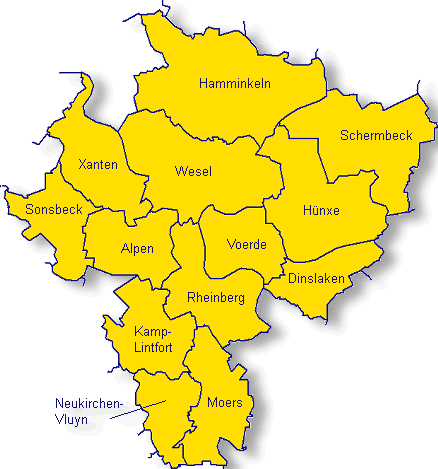
| Locations in the District WESEL (Source: Wikipedia) |
||||||||||||


| The following Ortsregister contains all places of the "Geschichtlichen Orts-Verzeichnisses" (GOV) of CompGen in WESEL. By activating the individual buttons in the four columns >Topo<, >SLUB<, >GOV< and >Meyers<, the geographical location of a place can be called up on a map from the geographical OpenTopoMap and Kartenforum or the place descriptions in the GOV-Ortsverzeichnis and Meyers Gazetteer. | ||||||||||||||||||||||||||
| A | B | C | D | E | F | G | H | I | J | K | L | M | N | O | P | Q | R | S | T | U | V | W | X | Y | Z | |
| Location | Distict | Location Typ | Coordinates | Topo | SLUB | GOV | Meyers | Community affiliation |
| Aaperh�fe | Wesel | Place | 51.6300 N 006.6500 E |  |
 |
 |
 |
Voerde (Niederrhein) |
| Abelkath | Wesel | Place | 51.6700 N 006.6500 E | |
|
|
|
Wesel |
| Abelmannshof | Wesel | Farmstead | 51.5700 N 006.5500 E | |
|
|
|
Rheinberg |
| Abelshof | Wesel | Place | 51.6700 N 006.6300 E | |
|
|
|
Wesel |
| Aberham | Wesel | Place | 51.7800 N 006.5300 E | |
|
|
|
Hamminkeln |
| Achterathsfeld | Wesel | District | 51.4090 N 006.5990 E | |
|
|
|
Moers |
| Achterathsheide | Wesel | District | 51.4010 N 006.5890 E | |
|
|
|
Moers |
| Achterhook | Wesel | District | 51.7800 N 006.5800 E | |
|
|
|
Hamminkeln |
| Ackermannshof | Wesel | Farmstead | 51.5200 N 006.6000 E | |
|
|
|
Rheinberg |
| Ackfeld | Wesel | District | 51.7200 N 007.8200 E | |
|
|
|
Hamm |
| Agnetenhof | Wesel | Place | |
|
Reichshof | |||
| Aldenhof | Wesel | District | 51.6800 N 006.9000 E | |
|
|
|
Schermbeck |
| Aldenhoff | Wesel | Farmstead | 51.5800 N 006.5300 E | |
|
|
|
Alpen |
| Alpen | Wesel | District | 51.5763 N 006.5139 E | |
|
|
|
Alpen |
| Alpsray | Wesel | District | 51.5300 N 006.5500 E | |
|
|
|
Rheinberg |
| Alsum | Wesel | Farming Community | 51.4964 N 006.7263 E | |
|
|
|
Duisburg |
| Alte Kolonie | Wesel | Place | 51.4300 N 006.5700 E | |
|
|
|
Neukirchen-Vluyn |
| Altenbruch | Wesel | Hamlet | 51.4200 N 006.6300 E | |
|
|
|
Moers |
| Alter Lackmannhof | Wesel | Deserted Settlement | 51.5048 N 006.6418 E | |
|
|
|
Duisburg |
| Altfeld | Wesel | Hamlet | 51.5200 N 006.5000 E | |
|
|
|
Kamp-Lintfort |
| Althof | Wesel | District | 51.5200 N 006.5000 E | |
|
|
|
Kamp-Lintfort |
| Altorwatershof | Wesel | Houses | 51.6686 N 006.4259 E | |
|
|
|
Xanten |
| Altschermbeck | Wesel | District | |
|
Schermbeck | |||
| Altschermbeck | Wesel | District | 51.6800 N 006.8800 E | |
|
|
|
Schermbeck |
| Altwardterholzhof | Wesel | District | 51.6500 N 006.3800 E | |
|
|
|
Xanten |
| Am D�lmen | Wesel | Residential Area | 51.6638 N 006.6819 E | |
|
|
|
Wesel |
| Am Heckler | Wesel | Farmstead | 51.5300 N 006.6200 E | |
|
|
|
Rheinberg |
| Am Sackert | Wesel | Place | 51.6700 N 006.5500 E | |
|
|
|
Wesel |
| An der Schanz | Wesel | Farmstead | 51.5583 N 006.6128 E | |
|
|
|
Rheinberg |
| Anhamm | Wesel | District | 51.5200 N 006.4700 E | |
|
|
|
Kamp-Lintfort |
| Annaberg | Wesel | District | 51.5300 N 006.5700 E | |
|
|
|
Rheinberg |
| Appenzeller | Wesel | Farmstead | 51.5800 N 006.4700 E | |
|
|
|
Alpen |
| Armenkath | Wesel | Farmstead | 51.6500 N 006.3500 E | |
|
|
|
Sonsbeck |
| Asberg | Wesel | District | 51.4300 N 006.6300 E | |
|
|
|
Moers |
| Asdonk | Wesel | District | 51.5000 N 006.5700 E | |
|
|
|
Kamp-Lintfort |
| Askamp | Wesel | Place | 51.7300 N 006.8500 E | |
|
|
|
Schermbeck |
| Assmannshof | Wesel | Houses | 51.6760 N 006.4270 E | |
|
|
|
Xanten |
| Aubruch | Wesel | District | 51.4140 N 006.6230 E | |
|
|
|
Moers |
| Auf dem Hammel | Wesel | District | 51.7000 N 006.3800 E | |
|
|
|
Xanten |
| Auf der N�ll | Wesel | Place | 51.2700 N 007.1500 E | |
|
|
|
Wuppertal |
| Averbruch | Wesel | City Subdistrict | |
|
Dinslaken | |||
| Averbruch | Wesel | City Subdistrict | 51.5516 N 006.7433 E | |
|
|
|
Dinslaken |
| Location | Distict | Location Typ | Coordinates | Topo | SLUB | GOV | Meyers | Community affiliation |
| Baaken | Wesel | District | 51.5200 N 006.5500 E | |
|
|
|
Kamp-Lintfort |
| BaerlagAltfeld | Wesel | Place | |
|
Br�hl | |||
| Baerler Busch | Wesel | Place | |
|
Geldern | |||
| Baerler Busch | Wesel | District | 51.4800 N 006.6600 E | |
|
|
|
Moers |
| Balberg | Wesel | Hamlet | 51.6200 N 006.3500 E | |
|
|
|
Sonsbeck |
| Baltushof | Wesel | District | 51.6700 N 006.3700 E | |
|
|
|
Xanten |
| Balzen | Wesel | District | 51.5500 N 006.4800 E | |
|
|
|
Kamp-Lintfort |
| Bandolahof | Wesel | District | 51.5700 N 006.4700 E | |
|
|
|
Alpen |
| B�nkerheide | Wesel | District | 51.6000 N 007.8200 E | |
|
|
|
Hamm |
| B�renschleuse | Wesel | Place | 51.6700 N 006.6500 E | |
|
|
|
Wesel |
| B�rlekenshof | Wesel | District | 51.6800 N 006.8000 E | |
|
|
|
Schermbeck |
| Barnefeld | Wesel | District | 51.7300 N 006.8200 E | |
|
|
|
Schermbeck |
| Barnefeldshof | Wesel | District | 51.6800 N 006.8000 E | |
|
|
|
Schermbeck |
| Barnstein | Wesel | District | 51.5000 N 006.4700 E | |
|
|
|
Kamp-Lintfort |
| Barnumerhof | Wesel | Farmstead | 51.6701 N 006.8345 E | |
|
|
|
H�nxe |
| Bartelt | Wesel | District | 51.6800 N 006.9000 E | |
|
|
|
Schermbeck |
| Bartenhof | Wesel | Farmstead | 51.6000 N 006.4000 E | |
|
|
|
Sonsbeck |
| Bauernschaft | Wesel | Place | |
|
Wadersloh | |||
| Baumeisterskath | Wesel | Place | 51.6800 N 006.7000 E | |
|
|
|
H�nxe |
| Baumgartner | Wesel | District | 51.5800 N 006.5000 E | |
|
|
|
Alpen |
| Beckmann | Wesel | Farmstead | 51.5500 N 006.5500 E | |
|
|
|
Rheinberg |
| Beckmannshof | Wesel | Farmstead | 51.6300 N 006.3800 E | |
|
|
|
Sonsbeck |
| Beek | Wesel | Hamlet | 51.6500 N 006.4700 E | |
|
|
|
Xanten |
| Behmershof | Wesel | District | 51.5200 N 006.5700 E | |
|
|
|
Kamp-Lintfort |
| Behrens | Wesel | Farmstead | 51.6500 N 006.3700 E | |
|
|
|
Sonsbeck |
| Benninghof | Wesel | Place | 51.6500 N 006.7800 E | |
|
|
|
H�nxe |
| Benninghoff | Wesel | Place | 51.6000 N 006.8000 E | |
|
|
|
H�nxe |
| Berg | Wesel | Farming Community | 51.7500 N 006.6300 E | |
|
|
|
Hamminkeln |
| Berg | Wesel | Hamlet | 51.4200 N 006.6170 E | |
|
|
|
Moers |
| Bergen | Wesel | Place | 51.7000 N 006.4800 E | |
|
|
|
Wesel |
| Bergenthun | Wesel | District | 51.6700 N 006.8700 E | |
|
|
|
Schermbeck |
| Bergerfurth | Wesel | Place | 51.7160 N 006.5160 E | |
|
|
|
Wesel |
| Bergerskath | Wesel | Place | 51.6800 N 006.7200 E | |
|
|
|
H�nxe |
| Bergmannshof | Wesel | District | 51.5700 N 006.4800 E | |
|
|
|
Alpen |
| Bergmannshof | Wesel | Place | 51.6500 N 006.7200 E | |
|
|
|
H�nxe |
| Bergmannskath | Wesel | Farmstead | 51.6332 N 006.4571 E | |
|
|
|
Xanten |
| Berndonkshof | Wesel | District | 51.6500 N 006.3800 E | |
|
|
|
Xanten |
| Bernshof | Wesel | Place | 51.5200 N 006.6300 E | |
|
|
|
Rheinberg |
| Bernshof | Wesel | Farmstead | 51.3819 N 006.7052 E | |
|
|
|
Duisburg |
| Besten | Wesel | District | 51.6500 N 006.8800 E | |
|
|
|
Schermbeck |
| Bettenkamp | Wesel | Hamlet | 51.4330 N 006.6090 E | |
|
|
|
Moers |
| Bettrayshof | Wesel | Farmstead | 51.6300 N 006.3200 E | |
|
|
|
Sonsbeck |
| Biekerskath | Wesel | District | 51.6700 N 006.4000 E | |
|
|
|
Xanten |
| Bienemannhof | Wesel | District | 51.6000 N 006.4300 E | |
|
|
|
Alpen |
| Biesendonkshof | Wesel | District | 51.6500 N 006.3800 E | |
|
|
|
Xanten |
| Billekath | Wesel | Place | 51.5700 N 006.5500 E | |
|
|
|
Rheinberg |
| Billemannshof | Wesel | Farmstead | 51.6000 N 006.4000 E | |
|
|
|
Sonsbeck |
| Birkenkamp | Wesel | Farmstead | 51.5800 N 006.4800 E | |
|
|
|
Alpen |
| Birkenkampshof | Wesel | District | 51.6500 N 006.4000 E | |
|
|
|
Xanten |
| Birnbaum | Wesel | Place | 51.5536 N 006.7122 E | |
|
|
|
Dinslaken |
| Birten | Wesel | City Subdistrict | 51.6300 N 006.4700 E | |
|
|
|
Xanten |
| Bischof | Wesel | District | 51.6700 N 006.8800 E | |
|
|
|
Schermbeck |
| Bislich | Wesel | District | 51.6700 N 006.4800 E | |
|
|
|
Wesel |
| Bislicher Insel | Wesel | Hamlet | 51.6450 N 006.4920 E | |
|
|
|
Xanten |
| Bislicher Wald | Wesel | Place | 51.7200 N 006.5500 E | |
|
|
|
Hamminkeln |
| Bislicherwald | Wesel | Farming Community | 51.7250 N 006.5510 E | |
|
|
|
Wesel |
| Blauhaus | Wesel | Farmstead | 51.6200 N 006.3700 E | |
|
|
|
Sonsbeck |
| Bleckmann | Wesel | Place | 51.5649 N 006.7148 E | |
|
|
|
Dinslaken |
| Bliersheim | Wesel | Village | 51.3920 N 006.7240 E | |
|
|
|
Duisburg |
| Blumberg | Wesel | District | 51.6800 N 006.8000 E | |
|
|
|
Schermbeck |
| Blumbergskath | Wesel | Place | 51.6200 N 006.7500 E | |
|
|
|
H�nxe |
| Blumenkamp | Wesel | Place | 51.6800 N 006.6000 E | |
|
|
|
Wesel |
| Blumenrath | Wesel | District | 50.8500 N 006.1800 E | |
|
|
|
Alsdorf |
| Blumenthal | Wesel | District | 51.5200 N 006.4500 E | |
|
|
|
Issum |
| Bockstegershof | Wesel | Farmstead | 51.6000 N 006.4500 E | |
|
|
|
Alpen |
| B�gel | Wesel | Farmstead | 51.6200 N 006.3700 E | |
|
|
|
Sonsbeck |
| B�gelshof | Wesel | District | 51.6200 N 006.3700 E | |
|
|
|
Sonsbeck |
| B�gelskath | Wesel | Farmstead | 51.6200 N 006.3700 E | |
|
|
|
Sonsbeck |
| B�hler Hof | Wesel | Place | 51.2300 N 007.1500 E | |
|
|
|
Wuppertal |
| B�hmer | Wesel | District | 51.6500 N 006.3800 E | |
|
|
|
Sonsbeck |
| Bohms | Wesel | District | 51.6800 N 006.8000 E | |
|
|
|
Schermbeck |
| Bohnekampshof | Wesel | Place | 51.6800 N 006.7300 E | |
|
|
|
H�nxe |
| B�ing | Wesel | District | 51.7800 N 006.5500 E | |
|
|
|
Hamminkeln |
| Boland | Wesel | Place | 51.7800 N 006.6000 E | |
|
|
|
Hamminkeln |
| Bollendonkshof | Wesel | District | 51.6700 N 006.3800 E | |
|
|
|
Xanten |
| B�llenhof | Wesel | Farmstead | 51.6000 N 006.4500 E | |
|
|
|
Alpen |
| Bollmann | Wesel | Place | 51.7800 N 006.6000 E | |
|
|
|
Hamminkeln |
| Bongartshof | Wesel | District | 51.5200 N 006.5300 E | |
|
|
|
Kamp-Lintfort |
| Bongers | Wesel | District | 51.5500 N 006.4700 E | |
|
|
|
Kamp-Lintfort |
| Bongershof | Wesel | Farmstead | 51.6277 N 006.4803 E | |
|
|
|
Xanten |
| Bongershof | Wesel | Place | 51.6500 N 006.5200 E | |
|
|
|
Wesel |
| Bongertshof | Wesel | District | 51.6700 N 006.4200 E | |
|
|
|
Xanten |
| Bongertskath | Wesel | Place | 51.6800 N 006.6700 E | |
|
|
|
Hamminkeln |
| Bongerzhof | Wesel | Farmstead | 51.5700 N 006.3700 E | |
|
|
|
Sonsbeck |
| B�nning | Wesel | District | 51.5800 N 006.5200 E | |
|
|
|
Alpen |
| B�nninghardt | Wesel | District | 51.5700 N 006.4700 E | |
|
|
|
Alpen |
| B�nninghardt I | Wesel | Hamlet | 51.5700 N 006.4700 E | |
|
|
|
Sonsbeck |
| B�nninghardt II | Wesel | Colony | 51.5700 N 006.4700 E | |
|
|
|
Alpen |
| B�nninghardt III | Wesel | Hamlet | 51.5590 N 006.4796 E | |
|
|
|
Kamp-Lintfort |
| Boomenhof | Wesel | Farmstead | 51.6000 N 006.4200 E | |
|
|
|
Alpen |
| Bornheim | Wesel | Hamlet | 51.4800 N 006.6300 E | |
|
|
|
Moers |
| Borth | Wesel | District | 51.5800 N 006.5500 E | |
|
|
|
Rheinberg |
| Boschmannshof | Wesel | District | 51.5200 N 006.5000 E | |
|
|
|
Kamp-Lintfort |
| Bossenhof | Wesel | Farmstead | 51.6200 N 006.3000 E | |
|
|
|
Sonsbeck |
| Bosserhof | Wesel | Farmstead | 51.6000 N 006.5000 E | |
|
|
|
Alpen |
| Bossigt | Wesel | Place | 51.6800 N 006.6300 E | |
|
|
|
Wesel |
| Brammenhof | Wesel | District | 51.6000 N 006.4300 E | |
|
|
|
Alpen |
| Branders | Wesel | District | 51.6300 N 006.3700 E | |
|
|
|
Sonsbeck |
| Brandhorsthof | Wesel | Farmstead | 51.5800 N 006.4700 E | |
|
|
|
Alpen |
| Brandhorsthof | Wesel | Farmstead | 51.6000 N 006.3700 E | |
|
|
|
Sonsbeck |
| Brandskath | Wesel | Farmstead | 51.6200 N 006.3800 E | |
|
|
|
Sonsbeck |
| Brangsh�uschen | Wesel | District | 51.6700 N 006.4000 E | |
|
|
|
Xanten |
| Bratherhof | Wesel | Place | 50.5200 N 006.3000 E | |
|
|
|
Monschau |
| Brau | Wesel | Hamlet | 51.5200 N 006.4700 E | |
|
|
|
Kamp-Lintfort |
| Breienhof | Wesel | Farmstead | 51.6200 N 006.3300 E | |
|
|
|
Sonsbeck |
| Bremannshof | Wesel | Place | 51.6500 N 006.7000 E | |
|
|
|
Wesel |
| Bremenkampshof | Wesel | Place | 51.5500 N 006.7800 E | |
|
|
|
Dinslaken |
| Bremerhof | Wesel | District | 51.5200 N 006.5000 E | |
|
|
|
Kamp-Lintfort |
| Bremmenkamp | Wesel | District | 51.6000 N 006.3800 E | |
|
|
|
Sonsbeck |
| Bremmers | Wesel | Farmstead | 51.6200 N 006.3000 E | |
|
|
|
Sonsbeck |
| Brendgeskath | Wesel | Place | 51.6800 N 006.6700 E | |
|
|
|
Wesel |
| Bricht | Wesel | District | 51.6800 N 006.8300 E | |
|
|
|
Schermbeck |
| Brinkmann | Wesel | Place | 51.6800 N 006.7000 E | |
|
|
|
H�nxe |
| Brinkmann | Wesel | Place | 51.6800 N 006.6700 E | |
|
|
|
Wesel |
| Br�mmenkamp | Wesel | Place | 51.5800 N 006.7500 E | |
|
|
|
H�nxe |
| Bruch | Wesel | Place | 51.5800 N 006.7300 E | |
|
|
|
Dinslaken |
| Bruchm�hle | Wesel | District | 51.6500 N 006.8700 E | |
|
|
|
Schermbeck |
| Bruchwiese | Wesel | District | 51.6300 N 006.8800 E | |
|
|
|
Schermbeck |
| Bruckchen | Wesel | Place | |
|
Wuppertal | |||
| Bruckhausen | Wesel | District | 51.5997 N 006.7542 E | |
|
|
|
H�nxe |
| Br�ckmannsfeld | Wesel | Place | 51.6000 N 006.6300 E | |
|
|
|
Voerde (Niederrhein) |
| Bruckmannshof | Wesel | District | 51.6800 N 006.8000 E | |
|
|
|
Schermbeck |
| Bruckmannshof | Wesel | Farmstead | 51.7003 N 006.3896 E | |
|
|
|
Xanten |
| Br�ckmannshof | Wesel | Place | 51.6000 N 006.6300 E | |
|
|
|
Voerde (Niederrhein) |
| Brucks | Wesel | Place | 51.6800 N 006.6800 E | |
|
|
|
H�nxe |
| Br�gemannskath | Wesel | Place | 51.6800 N 006.4800 E | |
|
|
|
Wesel |
| Br�ggemann | Wesel | District | 51.6800 N 006.8000 E | |
|
|
|
Schermbeck |
| Br�nen | Wesel | District | 51.7200 N 006.6800 E | |
|
|
|
Hamminkeln |
| Brunshof | Wesel | District | 51.6000 N 006.4300 E | |
|
|
|
Alpen |
| Bruxhof | Wesel | District | 51.5200 N 006.5300 E | |
|
|
|
Kamp-Lintfort |
| Buchholtwelmen | Wesel | Place | |
|
Lippetal | |||
| Buchholz | Wesel | District | 51.1170 N 006.3551 E | |
|
|
|
M�nchengladbach |
| Bucholt | Wesel | District | 51.6393 N 006.7230 E | |
|
|
|
H�nxe |
| B�ckemeier | Wesel | Place | 51.6300 N 006.7800 E | |
|
|
|
H�nxe |
| B�ckenhof | Wesel | Farmstead | 51.6000 N 006.4300 E | |
|
|
|
Alpen |
| Budberg | Wesel | District | 51.5300 N 006.6300 E | |
|
|
|
Rheinberg |
| B�derich | Wesel | City Subdistrict | 51.6290 N 006.5800 E | |
|
|
|
Wesel |
| B�hl | Wesel | Village | 51.6560 N 006.7997 E | |
|
|
|
H�nxe |
| B�hrenhof | Wesel | Farmstead | 51.6000 N 006.4500 E | |
|
|
|
Alpen |
| Buikenhof | Wesel | Farmstead | 51.6800 N 006.4000 E | |
|
|
|
Xanten |
| Bungers | Wesel | Place | 51.6000 N 006.6800 E | |
|
|
|
Voerde (Niederrhein) |
| Bunrathshof | Wesel | Place | 51.6700 N 006.7000 E | |
|
|
|
H�nxe |
| B�renhof | Wesel | Farmstead | 51.6200 N 006.4000 E | |
|
|
|
Sonsbeck |
| Burg | Wesel | District | 51.6200 N 006.4700 E | |
|
|
|
Alpen |
| Burmann | Wesel | Farmstead | 51.5700 N 006.4700 E | |
|
|
|
Alpen |
| Busch | Wesel | District | 51.6500 N 006.8700 E | |
|
|
|
Schermbeck |
| Buschmannshof | Wesel | Place | 51.5800 N 006.6800 E | |
|
|
|
Voerde (Niederrhein) |
| Location | Distict | Location Typ | Coordinates | Topo | SLUB | GOV | Meyers | Community affiliation |
| Claashof | Wesel | District | 51.6000 N 006.4500 E | |
|
|
|
Alpen |
| Clausenhof | Wesel | Place | 51.2700 N 007.1700 E | |
|
|
|
Wuppertal |
| Claushof | Wesel | Place | 51.5500 N 006.7000 E | |
|
|
|
Dinslaken |
| Clevenhof | Wesel | District | 51.5200 N 006.5300 E | |
|
|
|
Kamp-Lintfort |
| Clevenhof | Wesel | District | 51.6000 N 006.4500 E | |
|
|
|
Alpen |
| Clous | Wesel | Farmstead | 51.6200 N 006.3700 E | |
|
|
|
Sonsbeck |
| Colonie H�nxerwald | Wesel | Colony | 51.6191 N 006.7958 E | |
|
|
|
H�nxe |
| Colve | Wesel | Hamlet | 51.4200 N 006.6300 E | |
|
|
|
Moers |
| C�nenhof | Wesel | Farmstead | 51.6000 N 006.3300 E | |
|
|
|
Sonsbeck |
| Crusekath | Wesel | Place | 51.6700 N 006.5300 E | |
|
|
|
Wesel |
| Location | Distict | Location Typ | Coordinates | Topo | SLUB | GOV | Meyers | Community affiliation |
| Dachsberg | Wesel | District | 51.5000 N 006.4800 E | |
|
|
|
Kamp-Lintfort |
| Dachsbruch | Wesel | Hamlet | 51.4800 N 006.4700 E | |
|
|
|
Kamp-Lintfort |
| Dahlem | Wesel | District | 51.5200 N 006.4700 E | |
|
|
|
Kamp-Lintfort |
| Dahmenhof | Wesel | Farmstead | 51.6947 N 006.4173 E | |
|
|
|
Xanten |
| Dailschenhof | Wesel | District | 51.6500 N 006.3700 E | |
|
|
|
Sonsbeck |
| Dailschenkath | Wesel | Farmstead | 51.6500 N 006.3700 E | |
|
|
|
Sonsbeck |
| Damenhof | Wesel | Farmstead | 51.5645 N 006.5465 E | |
|
|
|
Rheinberg |
| Dameshof | Wesel | Place | 51.6700 N 006.7200 E | |
|
|
|
H�nxe |
| Damm | Wesel | District | 51.6700 N 006.8000 E | |
|
|
|
Schermbeck |
| D�mmerwald | Wesel | District | 51.7200 N 006.7800 E | |
|
|
|
Schermbeck |
| Dams | Wesel | District | 51.8000 N 006.5300 E | |
|
|
|
Hamminkeln |
| Dams Kolonie | Wesel | Farmstead | 51.5800 N 006.4000 E | |
|
|
|
Sonsbeck |
| Damskath | Wesel | Farmstead | 51.6300 N 006.3300 E | |
|
|
|
Sonsbeck |
| Deiters | Wesel | District | 51.6800 N 006.8800 E | |
|
|
|
Schermbeck |
| Dellmann | Wesel | District | 51.6800 N 006.7800 E | |
|
|
|
Schermbeck |
| Dellmannshof | Wesel | District | 51.6300 N 006.5000 E | |
|
|
|
Xanten |
| Dellshof | Wesel | Farmstead | 51.6000 N 006.4500 E | |
|
|
|
Alpen |
| der Schwan | Wesel | Place | 51.6700 N 006.6300 E | |
|
|
|
Wesel |
| Dickhof | Wesel | District | 51.6800 N 006.9000 E | |
|
|
|
Schermbeck |
| Dickmann | Wesel | Place | 51.6000 N 006.8000 E | |
|
|
|
H�nxe |
| Dickmannshof | Wesel | District | 51.6700 N 006.4000 E | |
|
|
|
Xanten |
| Dickmannshof | Wesel | District | 51.6800 N 006.8000 E | |
|
|
|
Schermbeck |
| Dickmannshof | Wesel | Place | 51.6500 N 006.7800 E | |
|
|
|
H�nxe |
| Dicksche Heide | Wesel | Hamlet | 51.4300 N 006.5300 E | |
|
|
|
Neukirchen-Vluyn |
| Dickskath | Wesel | Farmstead | 51.6000 N 006.4300 E | |
|
|
|
Alpen |
| Dickskath | Wesel | Farmstead | 51.5515 N 006.5528 E | |
|
|
|
Rheinberg |
| Die Schanz | Wesel | Farmstead | 51.5800 N 006.4700 E | |
|
|
|
Alpen |
| Diepenbruck | Wesel | District | 51.6700 N 006.7800 E | |
|
|
|
Schermbeck |
| Diepenbruckskath | Wesel | Place | 51.6800 N 006.7200 E | |
|
|
|
H�nxe |
| Diersfordt | Wesel | District | 51.6890 N 006.5440 E | |
|
|
|
Wesel |
| Dingden | Wesel | Village | 51.7700 N 006.6200 E | |
|
|
|
Hamminkeln |
| Dinslakener Bruch | Wesel | Place | 51.5814 N 006.7237 E | |
|
|
|
Dinslaken |
| Doctorshof | Wesel | Farmstead | 51.6200 N 006.3700 E | |
|
|
|
Sonsbeck |
| D�mershof | Wesel | Place | 51.6200 N 006.6000 E | |
|
|
|
Voerde (Niederrhein) |
| D�nberg | Wesel | Farming Community | 51.2980 N 007.1590 E | |
|
|
|
Wuppertal |
| Donk | Wesel | District | 51.2300 N 006.4500 E | |
|
|
|
M�nchengladbach |
| Donk | Wesel | Hamlet | 51.4780 N 006.5770 E | |
|
|
|
Moers |
| D�nningskate | Wesel | Place | 51.6800 N 006.5000 E | |
|
|
|
Wesel |
| Dorfbauerschaft | Wesel | Place | 51.7500 N 006.6000 E | |
|
|
|
Hamminkeln |
| Dorferrott | Wesel | Place | 51.7000 N 006.5800 E | |
|
|
|
Hamminkeln |
| Dorfferrott | Wesel | Place | |
|
Hamminkeln | |||
| D�rken | Wesel | District | 51.5200 N 006.5000 E | |
|
|
|
Kamp-Lintfort |
| Dormann | Wesel | District | 51.5200 N 006.5700 E | |
|
|
|
Kamp-Lintfort |
| Dormannshof | Wesel | District | 51.5200 N 006.5700 E | |
|
|
|
Kamp-Lintfort |
| D�rnemannshof | Wesel | District | 51.6000 N 006.4700 E | |
|
|
|
Alpen |
| D�rnerhof | Wesel | Farmstead | 51.4434 N 006.8095 E | |
|
|
|
Duisburg |
| Drevenack | Wesel | District | 51.6500 N 006.7300 E | |
|
|
|
H�nxe |
| Driesenhof | Wesel | Place | 51.6000 N 006.7200 E | |
|
|
|
H�nxe |
| Drie�en | Wesel | Hamlet | 51.5300 N 006.6700 E | |
|
|
|
Rheinberg |
| Drissenkath | Wesel | Farmstead | 51.6200 N 006.3500 E | |
|
|
|
Sonsbeck |
| Dr�genbergshof | Wesel | Place | 51.6700 N 006.5300 E | |
|
|
|
Wesel |
| Drost | Wesel | Farmstead | 51.5800 N 006.4700 E | |
|
|
|
Alpen |
| Drostenhof | Wesel | Farmstead | 51.6500 N 006.3700 E | |
|
|
|
Sonsbeck |
| Dr�ttboomshof | Wesel | Farmstead | 51.5700 N 006.5200 E | |
|
|
|
Alpen |
| Dr�pt | Wesel | District | |
|
Alpen | |||
| Dr�ptstein | Wesel | Farmstead | 51.5800 N 006.5300 E | |
|
|
|
Alpen |
| Dunkmannshof | Wesel | District | 51.6700 N 006.3700 E | |
|
|
|
Xanten |
| D�pmann | Wesel | District | 51.6800 N 006.8800 E | |
|
|
|
Schermbeck |
| Dussenkath | Wesel | Place | 51.8000 N 006.5200 E | |
|
|
|
Hamminkeln |
| D�sterhof | Wesel | District | 51.6700 N 006.3800 E | |
|
|
|
Xanten |
| Location | Distict | Location Typ | Coordinates | Topo | SLUB | GOV | Meyers | Community affiliation |
| Ebbers | Wesel | District | 51.7500 N 006.6300 E | |
|
|
|
Hamminkeln |
| Ebbert | Wesel | Place | 51.7300 N 006.8000 E | |
|
|
|
Schermbeck |
| Ebelershof | Wesel | Place | 51.7800 N 006.5300 E | |
|
|
|
Hamminkeln |
| Eichelk�mper | Wesel | Place | 51.6200 N 006.7700 E | |
|
|
|
H�nxe |
| Eick | Wesel | Hamlet | 51.4700 N 006.6200 E | |
|
|
|
Moers |
| Eicker Wiesen | Wesel | Place | |
|
Hille | |||
| Eickerskath | Wesel | Farmstead | 51.6283 N 006.4589 E | |
|
|
|
Xanten |
| Eickmanns Hof | Wesel | Farmstead | 51.6200 N 006.5200 E | |
|
|
|
Alpen |
| Eickschenhof | Wesel | District | 51.5000 N 006.6000 E | |
|
|
|
Moers |
| Eikelschulte | Wesel | District | 51.6700 N 006.8800 E | |
|
|
|
Schermbeck |
| Elberskath | Wesel | Place | 51.7800 N 006.5300 E | |
|
|
|
Hamminkeln |
| Elbert | Wesel | Place | 51.7300 N 006.8500 E | |
|
|
|
Schermbeck |
| Eldringshof | Wesel | Place | 51.6700 N 006.6500 E | |
|
|
|
Wesel |
| Ellern | Wesel | Place | 51.7200 N 006.5200 E | |
|
|
|
Wesel |
| Elmendorf | Wesel | District | 51.5300 N 006.5300 E | |
|
|
|
Kamp-Lintfort |
| Elsenhof | Wesel | Place | 51.6800 N 006.5000 E | |
|
|
|
Wesel |
| Emmelsum | Wesel | Place | 51.6200 N 006.6200 E | |
|
|
|
Voerde (Niederrhein) |
| Emmerichs | Wesel | Farmstead | 51.5700 N 006.5300 E | |
|
|
|
Alpen |
| Enck | Wesel | Place | 51.7800 N 006.7000 E | |
|
|
|
Hamminkeln |
| Endemann | Wesel | District | 51.6300 N 006.8800 E | |
|
|
|
Schermbeck |
| Endemanns | Wesel | District | 51.6800 N 006.8200 E | |
|
|
|
Schermbeck |
| Endschenhof | Wesel | Farmstead | 51.6000 N 006.4700 E | |
|
|
|
Alpen |
| Endschenhof | Wesel | District | 51.6700 N 006.4500 E | |
|
|
|
Xanten |
| Engelmannshof | Wesel | District | 51.6800 N 006.8300 E | |
|
|
|
Schermbeck |
| Enthofshof | Wesel | Place | 51.6700 N 006.5500 E | |
|
|
|
Wesel |
| Eppinghofen | Wesel | Farming Community | 51.5653 N 006.7027 E | |
|
|
|
Voerde (Niederrhein) |
| Eppinghoven | Wesel | City Subdistrict | |
|
Dinslaken | |||
| Eppinghoven | Wesel | Farming Community | 51.5653 N 006.7057 E | |
|
|
|
Dinslaken |
| Esselborn | Wesel | District | 51.5500 N 006.4700 E | |
|
|
|
Kamp-Lintfort |
| Esselt | Wesel | Place | 51.7000 N 006.7000 E | |
|
|
|
H�nxe |
| Ettwigshof | Wesel | Place | 51.5700 N 006.6200 E | |
|
|
|
Voerde (Niederrhein) |
| Eversael | Wesel | City Subdistrict | 51.5300 N 006.6500 E | |
|
|
|
Rheinberg |
| Eylmannshof | Wesel | Farmstead | 51.6000 N 006.4000 E | |
|
|
|
Sonsbeck |
| Location | Distict | Location Typ | Coordinates | Topo | SLUB | GOV | Meyers | Community affiliation |
| Feldbergshof | Wesel | Farmstead | 51.6239 N 006.4823 E | |
|
|
|
Xanten |
| Felderhof | Wesel | District | 51.6700 N 006.8800 E | |
|
|
|
Schermbeck |
| Feldhaus | Wesel | Place | 51.7700 N 006.7500 E | |
|
|
|
Raesfeld |
| Feldkamp | Wesel | Place | 51.6300 N 006.8000 E | |
|
|
|
H�nxe |
| Feldkampshof | Wesel | Place | 51.6700 N 006.6700 E | |
|
|
|
Wesel |
| Feldmark | Wesel | Place | 51.6700 N 006.6000 E | |
|
|
|
Wesel |
| Feldwick | Wesel | Place | 51.6700 N 006.4800 E | |
|
|
|
Wesel |
| Fengels | Wesel | District | 51.6500 N 006.8800 E | |
|
|
|
Schermbeck |
| Fingerhutshof | Wesel | Farmstead | 51.6200 N 006.4700 E | |
|
|
|
Alpen |
| Fischers Kath | Wesel | District | 51.6800 N 006.8800 E | |
|
|
|
Schermbeck |
| Fleischhof | Wesel | Farmstead | 51.6200 N 006.4300 E | |
|
|
|
Alpen |
| Fl�ren | Wesel | District | 51.6700 N 006.5700 E | |
|
|
|
Wesel |
| Foelshof | Wesel | Farmstead | 51.5800 N 006.4700 E | |
|
|
|
Alpen |
| Fork | Wesel | Place | 51.7700 N 006.7500 E | |
|
|
|
Raesfeld |
| Forsthaus Damm | Wesel | District | 51.6800 N 006.8000 E | |
|
|
|
Schermbeck |
| Forsthaus Winkel | Wesel | Farmstead | 51.5700 N 006.3700 E | |
|
|
|
Sonsbeck |
| Fort Bl�cher | Wesel | Residential Area | 51.6486 N 006.5849 E | |
|
|
|
Wesel |
| Franzenh�tte | Wesel | District | 51.3940 N 006.5930 E | |
|
|
|
Moers |
| Freudenberg Forsthaus | Wesel | Place | 51.7200 N 006.9200 E | |
|
|
|
Schermbeck |
| Freudenkath | Wesel | Place | 51.6200 N 006.6200 E | |
|
|
|
Wesel |
| Friedrichsfeld | Wesel | Place | 51.6289 N 006.6530 E | |
|
|
|
Voerde (Niederrhein) |
| Frielick | Wesel | Farming Community | 51.7200 N 007.8200 E | |
|
|
|
Hamm |
| Friem | Wesel | Place | 51.6000 N 006.8300 E | |
|
|
|
H�nxe |
| Friemshof | Wesel | District | 51.6800 N 006.8300 E | |
|
|
|
Schermbeck |
| Fuchshof | Wesel | Place | 51.6800 N 006.6200 E | |
|
|
|
Wesel |
| F�nderich | Wesel | District | 51.4500 N 006.6200 E | |
|
|
|
Moers |
| Fundermann | Wesel | District | 51.6800 N 006.8000 E | |
|
|
|
Schermbeck |
| F�rmann | Wesel | District | 51.5000 N 006.4700 E | |
|
|
|
Kamp-Lintfort |
| F�rstenberg | Wesel | Houses | 51.6493 N 006.4740 E | |
|
|
|
Xanten |
| F�rstgenskath | Wesel | Farmstead | 51.5800 N 006.4200 E | |
|
|
|
Alpen |
| Furth | Wesel | District | 51.6300 N 006.4000 E | |
|
|
|
Sonsbeck |
| Furtmannskath | Wesel | Place | 51.6800 N 006.5200 E | |
|
|
|
Wesel |
| Fustenhof | Wesel | Place | 51.6800 N 006.5000 E | |
|
|
|
Wesel |
| Fustenkath | Wesel | Place | 51.7800 N 006.5200 E | |
|
|
|
Hamminkeln |
| Fusternberg | Wesel | Place | 51.6500 N 006.6300 E | |
|
|
|
Wesel |
| Location | Distict | Location Typ | Coordinates | Topo | SLUB | GOV | Meyers | Community affiliation |
| Gahlen | Wesel | District | 51.6667 N 006.8749 E | |
|
|
|
Schermbeck |
| Gamerschlagshof | Wesel | Farmstead | 51.6329 N 006.4308 E | |
|
|
|
Xanten |
| Gansenberg | Wesel | Place | 51.6300 N 006.7500 E | |
|
|
|
H�nxe |
| Gardemann | Wesel | District | 51.5200 N 006.5300 E | |
|
|
|
Kamp-Lintfort |
| G�rtenskorte | Wesel | Place | 51.6500 N 006.7000 E | |
|
|
|
H�nxe |
| Gartrop | Wesel | District | 51.6607 N 006.8089 E | |
|
|
|
H�nxe |
| Geeremannshof | Wesel | Farmstead | 51.5800 N 006.4700 E | |
|
|
|
Alpen |
| Geerhof | Wesel | Farmstead | 51.5800 N 006.3700 E | |
|
|
|
Sonsbeck |
| Geilingshof | Wesel | District | 51.5300 N 006.5200 E | |
|
|
|
Kamp-Lintfort |
| Geisbruch | Wesel | City Subdistrict | 51.4800 N 006.5200 E | |
|
|
|
Kamp-Lintfort |
| Gelinde | Wesel | Estate | 51.5270 N 006.5900 E | |
|
|
|
Rheinberg |
| Genend | Wesel | District | 51.4700 N 006.5800 E | |
|
|
|
Moers |
| Germannshof | Wesel | District | 51.5800 N 006.4700 E | |
|
|
|
Alpen |
| Gerpheide | Wesel | Place | 51.6500 N 006.8000 E | |
|
|
|
H�nxe |
| Gertendorf | Wesel | Place | 51.7300 N 006.7300 E | |
|
|
|
Hamminkeln |
| Gessmann | Wesel | District | 51.5200 N 006.5500 E | |
|
|
|
Kamp-Lintfort |
| Ge�mann | Wesel | Farmstead | 51.5200 N 006.6000 E | |
|
|
|
Rheinberg |
| Gest | Wesel | District | 51.6340 N 006.5650 E | |
|
|
|
Wesel |
| Gesterhof | Wesel | Place | 51.6000 N 006.5800 E | |
|
|
|
Rheinberg |
| Gestfeld | Wesel | City Subdistrict | 51.4800 N 006.5300 E | |
|
|
|
Kamp-Lintfort |
| Gesthusen | Wesel | District | 51.6000 N 006.3800 E | |
|
|
|
Sonsbeck |
| Gesthuysen | Wesel | Hamlet | 51.7160 N 006.3834 E | |
|
|
|
Xanten |
| Gesthuyser Heide | Wesel | District | 51.7000 N 006.3700 E | |
|
|
|
Xanten |
| Gest�t Johannenhof | Wesel | Place | 51.5300 N 006.6500 E | |
|
|
|
Rheinberg |
| Giesbergshof | Wesel | Place | 51.8000 N 006.5200 E | |
|
|
|
Hamminkeln |
| Giethof | Wesel | Farmstead | 51.5728 N 006.3703 E | |
|
|
|
Sonsbeck |
| Gietlingsm�hle | Wesel | District | 51.6700 N 006.8500 E | |
|
|
|
H�nxe |
| Ginderich | Wesel | District | 51.6405 N 006.5440 E | |
|
|
|
Wesel |
| Gipkes | Wesel | Farmstead | 51.6500 N 006.3700 E | |
|
|
|
Sonsbeck |
| Gl�ckshof | Wesel | District | 51.5000 N 006.4700 E | |
|
|
|
Kamp-Lintfort |
| Gochskath | Wesel | Place | 51.6200 N 006.7000 E | |
|
|
|
Voerde (Niederrhein) |
| G�nnmann | Wesel | District | 51.5200 N 006.4700 E | |
|
|
|
Issum |
| G�rdshof | Wesel | Place | |
|
M�nchengladbach | |||
| Gorres | Wesel | Farmstead | 51.6300 N 006.3800 E | |
|
|
|
Sonsbeck |
| G�rtharshof | Wesel | Farmstead | 51.6000 N 006.4200 E | |
|
|
|
Alpen |
| Gossenhof | Wesel | Place | 51.6800 N 006.4800 E | |
|
|
|
Wesel |
| Gossenshof | Wesel | Farmstead | 51.6000 N 006.3800 E | |
|
|
|
Sonsbeck |
| G�tterswickerhamm | Wesel | Place | 51.5700 N 006.6500 E | |
|
|
|
Rheinberg |
| G�tterswickerhamm | Wesel | Village | 51.5807 N 006.6611 E | |
|
|
|
Voerde (Niederrhein) |
| Grafschaft | Wesel | Residential Area | 51.5932 N 006.8216 E | |
|
|
|
Dinslaken |
| Graft | Wesel | Hamlet | 51.5200 N 006.5700 E | |
|
|
|
Moers |
| Grefer | Wesel | District | 51.6500 N 006.8700 E | |
|
|
|
Schermbeck |
| Grenzlust | Wesel | Place | 51.6800 N 006.6200 E | |
|
|
|
Hamminkeln |
| Griesbarth | Wesel | District | 51.1200 N 006.3700 E | |
|
|
|
M�nchengladbach |
| Griesenbecke | Wesel | District | 51.2800 N 007.5000 E | |
|
|
|
Hagen |
| Griethskath | Wesel | Farmstead | 51.6200 N 006.3800 E | |
|
|
|
Sonsbeck |
| Grindt | Wesel | Estate | 51.6943 N 006.4479 E | |
|
|
|
Xanten |
| Grinshof | Wesel | Farmstead | 51.6200 N 006.4200 E | |
|
|
|
Sonsbeck |
| Gronenwald | Wesel | Farmstead | 51.6200 N 006.3700 E | |
|
|
|
Sonsbeck |
| Groot op Horst | Wesel | District | 51.5200 N 006.4700 E | |
|
|
|
Kamp-Lintfort |
| Gro� Eger | Wesel | Place | 51.6500 N 006.5700 E | |
|
|
|
Wesel |
| Gro�e G�nn | Wesel | District | 51.6300 N 006.4200 E | |
|
|
|
Xanten |
| Gro�e Ray | Wesel | Farmstead | 51.6050 N 006.5640 E | |
|
|
|
Rheinberg |
| Gro�er Haushof | Wesel | Place | 51.8000 N 006.5000 E | |
|
|
|
Hamminkeln |
| Gro�er Heeshof | Wesel | Farmstead | 51.6372 N 006.4630 E | |
|
|
|
Xanten |
| Gro�er Speelhof | Wesel | District | 51.6500 N 006.3700 E | |
|
|
|
Xanten |
| Gro�er Thalhof | Wesel | Farmstead | 51.5700 N 006.3700 E | |
|
|
|
Sonsbeck |
| Grotepa� | Wesel | District | 51.5000 N 006.4800 E | |
|
|
|
Kamp-Lintfort |
| Grunewald | Wesel | District | 51.5814 N 006.3846 E | |
|
|
|
Sonsbeck |
| Grunewald | Wesel | District | 51.6700 N 006.8700 E | |
|
|
|
Schermbeck |
| Grunland | Wesel | Deserted Settlement | 51.5589 N 006.6772 E | |
|
|
|
Rheinberg |
| Gr�ntgeshof | Wesel | District | 51.6200 N 006.3200 E | |
|
|
|
Sonsbeck |
| Gr�nthal | Wesel | Farmstead | 51.5800 N 006.5300 E | |
|
|
|
Alpen |
| Gr�tter | Wesel | District | 51.8000 N 006.6000 E | |
|
|
|
Hamminkeln |
| Gundershof | Wesel | District | 51.6800 N 006.4000 E | |
|
|
|
Xanten |
| Gut Loh | Wesel | Place | 51.6700 N 006.7000 E | |
|
|
|
Wesel |
| Gut Rheinische Ward | Wesel | Place | 51.6700 N 006.5700 E | |
|
|
|
Wesel |
| Gutshof Gl�ckauf | Wesel | Place | 51.6200 N 006.7000 E | |
|
|
|
Voerde (Niederrhein) |
| Location | Distict | Location Typ | Coordinates | Topo | SLUB | GOV | Meyers | Community affiliation |
| Haackmann | Wesel | District | 51.5200 N 006.4500 E | |
|
|
|
Issum |
| Haag | Wesel | Estate | 51.7160 N 006.3834 E | |
|
|
|
Xanten |
| Haagschenbuschkath | Wesel | Farmstead | 51.5800 N 006.4500 E | |
|
|
|
Alpen |
| Haagschenhof | Wesel | Farmstead | 51.5800 N 006.4500 E | |
|
|
|
Alpen |
| Haagscher Hof | Wesel | Farmstead | 51.6200 N 006.3200 E | |
|
|
|
Sonsbeck |
| Hagenkat | Wesel | Farmstead | 51.6336 N 006.4578 E | |
|
|
|
Xanten |
| Halfmannshof | Wesel | Farmstead | 51.5700 N 006.5200 E | |
|
|
|
Alpen |
| Halfmannshof | Wesel | Place | 51.5800 N 006.5800 E | |
|
|
|
Rheinberg |
| Halfmannshof | Wesel | District | 51.5200 N 006.5300 E | |
|
|
|
Kamp-Lintfort |
| Hallmannshof | Wesel | Farmstead | 51.6200 N 006.3500 E | |
|
|
|
Sonsbeck |
| Hallohskath | Wesel | Place | 51.6700 N 006.7500 E | |
|
|
|
H�nxe |
| Hamannshof | Wesel | Farmstead | 51.5298 N 006.5503 E | |
|
|
|
Rheinberg |
| Hamb | Wesel | District | 51.5500 N 006.3800 E | |
|
|
|
Sonsbeck |
| Hammann | Wesel | District | 51.5000 N 006.4800 E | |
|
|
|
Kamp-Lintfort |
| Hammerbruch | Wesel | Hamlet | 51.6200 N 006.4000 E | |
|
|
|
Sonsbeck |
| Haneshof | Wesel | Farmstead | 51.6300 N 006.3700 E | |
|
|
|
Sonsbeck |
| Hansenhof | Wesel | Place | 51.6800 N 006.5000 E | |
|
|
|
Wesel |
| Hardt | Wesel | Place | 51.5200 N 006.6200 E | |
|
|
|
Rheinberg |
| Hartigshof | Wesel | Farmstead | 51.6000 N 006.4000 E | |
|
|
|
Sonsbeck |
| Hartogshof | Wesel | Farmstead | 51.6200 N 006.3700 E | |
|
|
|
Sonsbeck |
| Hasenfeld | Wesel | Place | 51.5500 N 006.6700 E | |
|
|
|
Rheinberg |
| Hasselshof | Wesel | Estate | 51.5700 N 006.6500 E | |
|
|
|
Rheinberg |
| Haus Balken | Wesel | Estate | 51.6924 N 006.3888 E | |
|
|
|
Xanten |
| Haus Endt | Wesel | Place | 51.5700 N 006.6800 E | |
|
|
|
Dinslaken |
| Haus Erprath | Wesel | Estate | 51.6628 N 006.4388 E | |
|
|
|
Xanten |
| Haus Frohnenbruch | Wesel | Estate | 51.5080 N 006.4572 E | |
|
|
|
Kamp-Lintfort |
| Haus Heideck | Wesel | Estate | 51.5500 N 006.5300 E | |
|
|
|
Kamp-Lintfort |
| Haus Hiesfeld | Wesel | Estate | 51.5663 N 006.7749 E | |
|
|
|
Dinslaken |
| Haus Lau | Wesel | Estate | 51.6367 N 006.4735 E | |
|
|
|
Xanten |
| Haus Loo | Wesel | Farmstead | 51.5800 N 006.5200 E | |
|
|
|
Alpen |
| Haus Mehrum | Wesel | Place | 51.5760 N 006.6190 E | |
|
|
|
Voerde (Niederrhein) |
| Haus Wohnung | Wesel | Place | 51.5732 N 006.6903 E | |
|
|
|
Voerde (Niederrhein) |
| Hauschehof | Wesel | District | 51.6700 N 006.3700 E | |
|
|
|
Xanten |
| Hausmannshof | Wesel | District | 51.5000 N 006.6000 E | |
|
|
|
Moers |
| Havelich | Wesel | Place | 51.7500 N 006.7300 E | |
|
|
|
Hamminkeln |
| H�xkeshof | Wesel | Farmstead | 51.5700 N 006.5300 E | |
|
|
|
Alpen |
| Hebbershof | Wesel | Farmstead | 51.6418 N 006.2986 E | |
|
|
|
Sonsbeck |
| Heberingshof | Wesel | Farmstead | 51.5700 N 006.5300 E | |
|
|
|
Alpen |
| Hecheltjen | Wesel | District | 51.6800 N 006.8500 E | |
|
|
|
Schermbeck |
| Hedjen-Nuyken | Wesel | Place | 51.6500 N 006.9000 E | |
|
|
|
Schermbeck |
| Heeger Feld | Wesel | Place | 51.6000 N 006.6300 E | |
|
|
|
Voerde (Niederrhein) |
| Heeger Hof | Wesel | Place | 51.6000 N 006.6300 E | |
|
|
|
Voerde (Niederrhein) |
| Heekermannshof | Wesel | Farmstead | 51.5500 N 006.3700 E | |
|
|
|
Sonsbeck |
| Heesenhof | Wesel | Farmstead | 51.5200 N 006.6300 E | |
|
|
|
Rheinberg |
| Heesenhof | Wesel | Place | 51.6300 N 006.7200 E | |
|
|
|
H�nxe |
| Heesenhof | Wesel | District | 51.6700 N 006.3700 E | |
|
|
|
Xanten |
| Heideland | Wesel | Place | 51.6000 N 006.6300 E | |
|
|
|
Voerde (Niederrhein) |
| Heidelust | Wesel | Place | |
|
Bad Salzuflen | |||
| Heiderott | Wesel | Place | 51.7000 N 006.5800 E | |
|
|
|
Hamminkeln |
| Heidesiedlung | Wesel | Place | 51.6200 N 006.6700 E | |
|
|
|
Voerde (Niederrhein) |
| Heiermannshof | Wesel | Place | 51.5800 N 006.7300 E | |
|
|
|
H�nxe |
| Heikenskath | Wesel | Place | 51.6200 N 006.6700 E | |
|
|
|
Voerde (Niederrhein) |
| Heilmannshof | Wesel | Farmstead | 51.6500 N 006.3500 E | |
|
|
|
Sonsbeck |
| Heimannshof | Wesel | Farmstead | 51.6200 N 006.4800 E | |
|
|
|
Alpen |
| Heinenkath | Wesel | Place | 51.5300 N 006.5300 E | |
|
|
|
Rheinberg |
| Heisenfeld | Wesel | Farmstead | 51.6200 N 006.3500 E | |
|
|
|
Sonsbeck |
| Heisterkamp | Wesel | District | 51.6500 N 006.8500 E | |
|
|
|
Schermbeck |
| Heix | Wesel | Farmstead | 51.5800 N 006.5300 E | |
|
|
|
Alpen |
| Hellermann | Wesel | Farmstead | 51.7700 N 006.7300 E | |
|
|
|
Hamminkeln |
| Hellmannshof | Wesel | Farmstead | 51.6200 N 006.3200 E | |
|
|
|
Sonsbeck |
| Helterdyk | Wesel | District | 51.5700 N 006.4500 E | |
|
|
|
Alpen |
| Heltgen | Wesel | District | 51.5200 N 006.4500 E | |
|
|
|
Issum |
| Hemmerhof | Wesel | Farmstead | 51.5800 N 006.4800 E | |
|
|
|
Alpen |
| Hemmert | Wesel | District | 51.6500 N 006.8700 E | |
|
|
|
Schermbeck |
| Hemmert-Halswick | Wesel | District | 51.6500 N 006.8800 E | |
|
|
|
Schermbeck |
| Hen op den Damm | Wesel | Place | 51.6000 N 006.6800 E | |
|
|
|
Voerde (Niederrhein) |
| Hennesenhof | Wesel | District | 51.6908 N 006.3918 E | |
|
|
|
Xanten |
| Herck | Wesel | Farming Community | 51.4490 N 006.5980 E | |
|
|
|
Moers |
| Hercken | Wesel | District | 51.5000 N 006.4700 E | |
|
|
|
Kamp-Lintfort |
| Herkenhof | Wesel | District | 51.5300 N 006.5300 E | |
|
|
|
Kamp-Lintfort |
| Hermeshof | Wesel | Farmstead | 51.5700 N 006.3700 E | |
|
|
|
Sonsbeck |
| Hermeshof | Wesel | District | 51.5000 N 006.5800 E | |
|
|
|
Moers |
| Hermeskath | Wesel | Farmstead | 51.5442 N 006.5544 E | |
|
|
|
Rheinberg |
| Hessing | Wesel | District | 51.7300 N 006.7800 E | |
|
|
|
Schermbeck |
| Hessingskath | Wesel | Place | 51.6800 N 006.6700 E | |
|
|
|
Hamminkeln |
| Heubergshof | Wesel | Farmstead | 51.6283 N 006.4685 E | |
|
|
|
Xanten |
| Heukershof | Wesel | District | 51.6700 N 006.4000 E | |
|
|
|
Xanten |
| Heyenhof | Wesel | District | 51.6700 N 006.8000 E | |
|
|
|
Schermbeck |
| Heyermann | Wesel | Place | 51.6000 N 006.8000 E | |
|
|
|
H�nxe |
| Hiel | Wesel | Place | 51.6700 N 006.5300 E | |
|
|
|
Wesel |
| Hiesfeld | Wesel | Rural Municipality | |
|
Dinslaken | |||
| Hillmannshof | Wesel | Farmstead | 51.5700 N 006.5300 E | |
|
|
|
Alpen |
| Himmbruchshof | Wesel | Place | 51.5800 N 006.6500 E | |
|
|
|
Voerde (Niederrhein) |
| Hingstenhof | Wesel | District | 51.6200 N 006.3300 E | |
|
|
|
Sonsbeck |
| Hinsenhof | Wesel | Farmstead | 51.6000 N 006.4000 E | |
|
|
|
Sonsbeck |
| Hinter den K�mpen | Wesel | Place | |
|
Steinheim | |||
| Hitsfeldhof | Wesel | Farmstead | 51.6919 N 006.4283 E | |
|
|
|
Xanten |
| Hochbruch | Wesel | Hamlet | 51.6500 N 006.4300 E | |
|
|
|
Xanten |
| Hochkamer | Wesel | Residential Area | 51.4500 N 006.5300 E | |
|
|
|
Neukirchen-Vluyn |
| Hochstra� | Wesel | District | 51.4300 N 006.6500 E | |
|
|
|
Moers |
| Hochstra� | Wesel | District | 51.4500 N 006.6500 E | |
|
|
|
Moers |
| H�ckershof | Wesel | District | 51.6300 N 006.4200 E | |
|
|
|
Sonsbeck |
| Hoerstgen | Wesel | City Subdistrict | 51.5000 N 006.4700 E | |
|
|
|
Kamp-Lintfort |
| Hoerstgener | Wesel | District | 51.5000 N 006.4700 E | |
|
|
|
Kamp-Lintfort |
| Hoerstgener Huck | Wesel | Farming Community | 51.5073 N 006.4829 E | |
|
|
|
Kamp-Lintfort |
| Hoerstgenshof | Wesel | District | 51.5300 N 006.5200 E | |
|
|
|
Kamp-Lintfort |
| Hoffmanns Kolonie | Wesel | Farmstead | 51.5800 N 006.4700 E | |
|
|
|
Alpen |
| Hoffmannshof | Wesel | District | 51.5200 N 006.4700 E | |
|
|
|
Kamp-Lintfort |
| H�fkenshof | Wesel | Place | 51.6700 N 006.7000 E | |
|
|
|
H�nxe |
| Hogeforster | Wesel | Place | |
|
Bocholt | |||
| Hogekath | Wesel | Farmstead | 51.6200 N 006.3700 E | |
|
|
|
Sonsbeck |
| Hohe Wart | Wesel | Place | 51.6000 N 006.8200 E | |
|
|
|
H�nxe |
| Hohenhinnebusch | Wesel | District | 51.6800 N 006.9000 E | |
|
|
|
Schermbeck |
| Hohen-Malberg | Wesel | Place | 51.6700 N 006.6800 E | |
|
|
|
Wesel |
| Holderberg | Wesel | District | 51.4230 N 006.6160 E | |
|
|
|
Moers |
| Holderberg-Bettenkamp | Wesel | Place | |
|
Petershagen | |||
| Holland | Wesel | Farmstead | 51.6000 N 006.3300 E | |
|
|
|
Sonsbeck |
| Hollandshof | Wesel | Place | 51.6800 N 006.4800 E | |
|
|
|
Wesel |
| Hollandshof | Wesel | District | 51.6485 N 006.4124 E | |
|
|
|
Xanten |
| Holtermanndhof | Wesel | Farmstead | 51.6000 N 006.4000 E | |
|
|
|
Sonsbeck |
| Holtermannshof | Wesel | Place | 51.6500 N 006.7200 E | |
|
|
|
H�nxe |
| Holtermannskath | Wesel | Farmstead | 51.6000 N 006.4000 E | |
|
|
|
Sonsbeck |
| H�ltershof | Wesel | Farmstead | 51.6000 N 006.4300 E | |
|
|
|
Alpen |
| H�ltges | Wesel | Farmstead | 51.6200 N 006.4000 E | |
|
|
|
Sonsbeck |
| Holthausen | Wesel | Place | 51.6065 N 006.6783 E | |
|
|
|
Voerde (Niederrhein) |
| Holthauserfeld | Wesel | Place | 51.6200 N 006.6800 E | |
|
|
|
H�nxe |
| Holtmannshof | Wesel | District | 51.6300 N 006.5000 E | |
|
|
|
Xanten |
| Holtmannshof | Wesel | District | 51.6800 N 006.8000 E | |
|
|
|
Schermbeck |
| Holtsteg | Wesel | Place | 51.5383 N 006.7814 E | |
|
|
|
Dinslaken |
| Holtstegshof | Wesel | District | 51.5200 N 006.5000 E | |
|
|
|
Kamp-Lintfort |
| Hombergshof | Wesel | Place | 51.6700 N 006.5300 E | |
|
|
|
Wesel |
| Hondelmann | Wesel | Place | 51.6200 N 006.7200 E | |
|
|
|
H�nxe |
| Honnenhof | Wesel | District | 51.5200 N 006.4500 E | |
|
|
|
Issum |
| H�nshof | Wesel | Farmstead | 51.6300 N 006.4000 E | |
|
|
|
Sonsbeck |
| Honvehlmann | Wesel | Place | 51.7300 N 006.8500 E | |
|
|
|
Schermbeck |
| Hoogenhof | Wesel | District | 51.5200 N 006.5200 E | |
|
|
|
Kamp-Lintfort |
| Hopmannshof | Wesel | Farmstead | 51.5500 N 006.6300 E | |
|
|
|
Rheinberg |
| H�ppenhof | Wesel | Place | 51.6800 N 006.4800 E | |
|
|
|
Wesel |
| H�rnemanns Kamp | Wesel | Place | 51.4827 N 006.6424 E | |
|
|
|
Moers |
| Hornemannshof | Wesel | Farmstead | 51.5469 N 006.5521 E | |
|
|
|
Rheinberg |
| Horstk�mpskath | Wesel | Place | 51.6000 N 006.8000 E | |
|
|
|
H�nxe |
| Horstmann | Wesel | Farmstead | 51.6300 N 006.3800 E | |
|
|
|
Sonsbeck |
| Horstmannshof | Wesel | Farmstead | 51.5429 N 006.5456 E | |
|
|
|
Rheinberg |
| Horstmannshof | Wesel | Place | 51.6000 N 006.7200 E | |
|
|
|
H�nxe |
| Horstmannskath | Wesel | Place | 51.6200 N 006.8200 E | |
|
|
|
H�nxe |
| H�velkath | Wesel | Farmstead | 51.6200 N 006.3800 E | |
|
|
|
Sonsbeck |
| H�velsberg | Wesel | Place | |
|
Willich | |||
| H�velshof | Wesel | Farmstead | 51.6000 N 006.4300 E | |
|
|
|
Alpen |
| H�velskath | Wesel | Place | 51.7800 N 006.5000 E | |
|
|
|
Hamminkeln |
| Huck | Wesel | District | |
|
Alpen | |||
| Huck H�ningshof | Wesel | Farmstead | 51.5700 N 006.5300 E | |
|
|
|
Alpen |
| H�fkeskate | Wesel | Place | 51.6800 N 006.5000 E | |
|
|
|
Wesel |
| H�g | Wesel | Farmstead | 51.6500 N 006.3500 E | |
|
|
|
Sonsbeck |
| H�genhof | Wesel | Farmstead | 51.6200 N 006.3300 E | |
|
|
|
Sonsbeck |
| H�ging | Wesel | Place | 51.7700 N 006.7500 E | |
|
|
|
Raesfeld |
| H�hnerheide | Wesel | Place | 51.5500 N 006.7800 E | |
|
|
|
Dinslaken |
| H�hnerhort | Wesel | Hamlet | 51.4300 N 006.6300 E | |
|
|
|
Moers |
| H�lsdonk | Wesel | District | 51.4500 N 006.5800 E | |
|
|
|
Moers |
| H�lsemannshof | Wesel | Place | 51.5700 N 006.7500 E | |
|
|
|
Dinslaken |
| H�lser | Wesel | Place | 51.6000 N 006.6700 E | |
|
|
|
Voerde (Niederrhein) |
| H�lshof | Wesel | Farmstead | 51.5500 N 006.3700 E | |
|
|
|
Sonsbeck |
| H�lshorst | Wesel | Place | 51.7300 N 006.5500 E | |
|
|
|
Hamminkeln |
| H�lshorst | Wesel | Hamlet | 51.4200 N 006.5800 E | |
|
|
|
Moers |
| H�lskensweg | Wesel | District | 51.4150 N 006.5780 E | |
|
|
|
Moers |
| H�lsmann | Wesel | District | 51.6800 N 006.8200 E | |
|
|
|
Schermbeck |
| H�nerpa�hof | Wesel | Farmstead | 51.6366 N 006.2993 E | |
|
|
|
Sonsbeck |
| H�nxe | Wesel | Village | 51.6426 N 006.7663 E | |
|
|
|
H�nxe |
| H�nxerheide | Wesel | Place | 51.6000 N 006.8200 E | |
|
|
|
H�nxe |
| H�rdemannshof | Wesel | District | 51.6800 N 006.4000 E | |
|
|
|
Xanten |
| H�renhof | Wesel | District | 51.1800 N 006.4700 E | |
|
|
|
M�nchengladbach |
| H�sch | Wesel | Farmstead | 51.5700 N 006.5200 E | |
|
|
|
Alpen |
| H�sch-Grotfeld | Wesel | Farmstead | 51.5700 N 006.5300 E | |
|
|
|
Alpen |
| H�schskath | Wesel | Farmstead | 51.5500 N 006.5300 E | |
|
|
|
Rheinberg |
| Husen | Wesel | Hamlet | 51.7400 N 006.4110 E | |
|
|
|
Xanten |
| Husenhof | Wesel | Farmstead | 51.6000 N 006.3500 E | |
|
|
|
Sonsbeck |
| Husenhof | Wesel | Place | 51.6500 N 006.5700 E | |
|
|
|
Wesel |
| Husenhof | Wesel | Farmstead | 51.7419 N 006.4113 E | |
|
|
|
Xanten |
| H�ser | Wesel | District | 51.5200 N 006.4700 E | |
|
|
|
Issum |
| H�sken | Wesel | District | 51.7300 N 006.7800 E | |
|
|
|
Schermbeck |
| Hu�mannskath | Wesel | Place | 51.6300 N 006.6300 E | |
|
|
|
Wesel |
| H�ttermann | Wesel | Place | 51.6500 N 006.9000 E | |
|
|
|
Schermbeck |
| Location | Distict | Location Typ | Coordinates | Topo | SLUB | GOV | Meyers | Community affiliation |
| Ifangshof | Wesel | District | 51.5200 N 006.5000 E | |
|
|
|
Kamp-Lintfort |
| Illschenhof | Wesel | Place | 51.6300 N 006.5200 E | |
|
|
|
Wesel |
| Im Sand | Wesel | District | 51.6700 N 006.8700 E | |
|
|
|
Schermbeck |
| Im Strang | Wesel | District | 51.3300 N 007.5200 E | |
|
|
|
Hagen |
| Imighof | Wesel | District | 51.5000 N 006.6000 E | |
|
|
|
Moers |
| In der Hufe | Wesel | Place | 51.6800 N 006.6200 E | |
|
|
|
Wesel |
| Ingenschay | Wesel | District | 51.5000 N 006.4700 E | |
|
|
|
Kamp-Lintfort |
| Isselbruch | Wesel | Place | 51.6800 N 006.6300 E | |
|
|
|
Wesel |
| Isselhof | Wesel | Place | 51.6800 N 006.6700 E | |
|
|
|
H�nxe |
| Isselhorst | Wesel | District | 51.6300 N 006.8800 E | |
|
|
|
Schermbeck |
| Isselhorst | Wesel | Place | 51.6700 N 006.6500 E | |
|
|
|
Wesel |
| Isselmannshof | Wesel | Place | 51.6800 N 006.6200 E | |
|
|
|
Wesel |
| Isselrott | Wesel | Place | 51.7000 N 006.6000 E | |
|
|
|
Hamminkeln |
| Itgeshorstkath | Wesel | Place | 51.6800 N 006.6700 E | |
|
|
|
Wesel |
| Iv�ngerskath | Wesel | Farmstead | 51.6200 N 006.3500 E | |
|
|
|
Sonsbeck |
| Location | Distict | Location Typ | Coordinates | Topo | SLUB | GOV | Meyers | Community affiliation |
| Jagdhof | Wesel | Place | 51.6300 N 006.8000 E | |
|
|
|
H�nxe |
| J�gerruh | Wesel | District | 51.6200 N 006.4800 E | |
|
|
|
Alpen |
| Janinhoff | Wesel | Place | 51.6000 N 006.8500 E | |
|
|
|
Dinslaken |
| Janzen | Wesel | District | 51.6800 N 006.8200 E | |
|
|
|
Schermbeck |
| J�ckern | Wesel | Place | 51.6800 N 006.4800 E | |
|
|
|
Wesel |
| Johanneshof | Wesel | District | 51.6500 N 006.4200 E | |
|
|
|
Xanten |
| J�rreshof | Wesel | District | 51.5000 N 006.5500 E | |
|
|
|
Kamp-Lintfort |
| J�rris | Wesel | District | 51.5500 N 006.4800 E | |
|
|
|
Kamp-Lintfort |
| Josten | Wesel | District | 51.6300 N 006.9000 E | |
|
|
|
Schermbeck |
| Jungermannshof | Wesel | Farmstead | 51.6300 N 006.3300 E | |
|
|
|
Sonsbeck |
| Jungmannshof | Wesel | Place | 51.2800 N 007.1000 E | |
|
|
|
Wuppertal |
| Junkershof | Wesel | Place | 51.6700 N 006.6500 E | |
|
|
|
Wesel |
| J�ttendonkshof | Wesel | Farmstead | 51.6524 N 006.4107 E | |
|
|
|
Xanten |
| Location | Distict | Location Typ | Coordinates | Topo | SLUB | GOV | Meyers | Community affiliation |
| Kahlenhof | Wesel | District | 51.5200 N 006.5300 E | |
|
|
|
Kamp-Lintfort |
| Kaiserhorst | Wesel | Place | 51.7800 N 006.5300 E | |
|
|
|
Hamminkeln |
| Kaisershof | Wesel | Farmstead | 51.5800 N 006.4700 E | |
|
|
|
Alpen |
| Kalbeckshof | Wesel | Place | 51.5800 N 006.6800 E | |
|
|
|
Voerde (Niederrhein) |
| Kalbfleisch | Wesel | Farmstead | 51.5700 N 006.4700 E | |
|
|
|
Alpen |
| Kalscheuer | Wesel | Farmstead | 51.6200 N 006.3300 E | |
|
|
|
Sonsbeck |
| Kamannshof | Wesel | Farmstead | 51.5525 N 006.5498 E | |
|
|
|
Rheinberg |
| Kamp | Wesel | City Subdistrict | 51.5035 N 006.5169 E | |
|
|
|
Kamp-Lintfort |
| Kamperbruch | Wesel | City Subdistrict | 51.5090 N 006.5400 E | |
|
|
|
Kamp-Lintfort |
| Kamperbr�ck | Wesel | City Subdistrict | 51.5000 N 006.4800 E | |
|
|
|
Kamp-Lintfort |
| Kampermannshof | Wesel | Place | 51.6700 N 006.7000 E | |
|
|
|
Wesel |
| Kampermannshof | Wesel | Place | 51.6000 N 006.7300 E | |
|
|
|
H�nxe |
| Kamphaus | Wesel | District | 51.6500 N 006.8700 E | |
|
|
|
Schermbeck |
| K�mpke | Wesel | Residential Area | 51.6200 N 006.4700 E | |
|
|
|
Xanten |
| K�mpken | Wesel | Farmstead | 51.6200 N 006.3200 E | |
|
|
|
Sonsbeck |
| K�mpkenshof | Wesel | Farmstead | 51.6200 N 006.3200 E | |
|
|
|
Sonsbeck |
| Kampshof | Wesel | District | 51.6800 N 006.8000 E | |
|
|
|
Schermbeck |
| Kamp�t | Wesel | Place | 51.6800 N 006.7000 E | |
|
|
|
H�nxe |
| Kandershof | Wesel | Farmstead | 51.5800 N 006.4700 E | |
|
|
|
Alpen |
| Kapellen | Wesel | City Subdistrict | 51.4181 N 006.5946 E | |
|
|
|
Moers |
| Kapellsche Bruch | Wesel | District | 51.5700 N 006.3800 E | |
|
|
|
Sonsbeck |
| Kattlack | Wesel | Farmstead | 51.5200 N 006.6500 E | |
|
|
|
Rheinberg |
| Kaysershof | Wesel | Farmstead | 51.6300 N 006.3200 E | |
|
|
|
Sonsbeck |
| Kellewaldshof | Wesel | Farmstead | 51.6200 N 006.3300 E | |
|
|
|
Sonsbeck |
| Kellwing | Wesel | District | 51.6500 N 006.8700 E | |
|
|
|
Schermbeck |
| Kemperhof | Wesel | District | 51.6800 N 006.8300 E | |
|
|
|
Schermbeck |
| Kempken | Wesel | Place | 51.7300 N 006.8300 E | |
|
|
|
Schermbeck |
| Kerstenhof | Wesel | Place | 51.6800 N 006.5200 E | |
|
|
|
Wesel |
| Kerstgenshof | Wesel | Farmstead | 51.6500 N 006.3700 E | |
|
|
|
Sonsbeck |
| Kerstheide | Wesel | District | 51.6200 N 007.7000 E | |
|
|
|
Hamm |
| Kesseldorf | Wesel | Place | 51.7300 N 006.5700 E | |
|
|
|
Hamminkeln |
| Kettgeshof | Wesel | Estate | 51.5500 N 006.6500 E | |
|
|
|
Rheinberg |
| Keuschenhof | Wesel | Farmstead | 51.5190 N 006.6488 E | |
|
|
|
Rheinberg |
| Keusenhof | Wesel | District | 51.5200 N 006.5000 E | |
|
|
|
Kamp-Lintfort |
| Kirchhof | Wesel | Hamlet | 51.5000 N 006.4800 E | |
|
|
|
Kamp-Lintfort |
| Kiwitt | Wesel | Farmstead | 51.6200 N 006.3800 E | |
|
|
|
Sonsbeck |
| Klappbaum | Wesel | Farmstead | 51.5800 N 006.4000 E | |
|
|
|
Sonsbeck |
| Klein Eger | Wesel | Place | 51.6500 N 006.5700 E | |
|
|
|
Wesel |
| Klein op Horst | Wesel | District | 51.5000 N 006.4700 E | |
|
|
|
Kamp-Lintfort |
| Kleinbergerhof | Wesel | Place | 51.5700 N 006.7700 E | |
|
|
|
Dinslaken |
| Kleine Bergskath | Wesel | Farmstead | 51.5800 N 006.4500 E | |
|
|
|
Alpen |
| Kleine Bongardt | Wesel | District | 51.5000 N 006.5700 E | |
|
|
|
Moers |
| Kleine G�nn | Wesel | District | 51.6300 N 006.4000 E | |
|
|
|
Xanten |
| Kleine Hardt | Wesel | Farmstead | 51.5144 N 006.6246 E | |
|
|
|
Rheinberg |
| Kleine Ray | Wesel | Farmstead | 51.6054 N 006.5649 E | |
|
|
|
Rheinberg |
| Kleinefeldshof | Wesel | District | 51.5300 N 006.4500 E | |
|
|
|
Issum |
| Kleiner Haushof | Wesel | Place | 51.8000 N 006.5000 E | |
|
|
|
Hamminkeln |
| Kleiner Thalhof | Wesel | Farmstead | 51.5700 N 006.3700 E | |
|
|
|
Sonsbeck |
| Kleinheeshof | Wesel | Farmstead | 51.6371 N 006.4613 E | |
|
|
|
Xanten |
| Kleverhof | Wesel | District | 51.6500 N 006.4000 E | |
|
|
|
Xanten |
| Klompenhof | Wesel | District | 51.5200 N 006.5300 E | |
|
|
|
Kamp-Lintfort |
| Kl�ppenberg | Wesel | Place | 51.6700 N 006.5800 E | |
|
|
|
Wesel |
| Kloppert | Wesel | Place | 51.6200 N 006.7700 E | |
|
|
|
H�nxe |
| Klo�hof | Wesel | Place | 51.6700 N 006.6800 E | |
|
|
|
Wesel |
| Kn�fershof | Wesel | Place | 51.6800 N 006.7000 E | |
|
|
|
H�nxe |
| Kockshof | Wesel | Place | 51.6700 N 006.5500 E | |
|
|
|
Wesel |
| Koetershof | Wesel | District | 51.6000 N 006.4500 E | |
|
|
|
Alpen |
| Kohlenhuck | Wesel | Hamlet | 51.5000 N 006.5800 E | |
|
|
|
Moers |
| Kohleskath | Wesel | Farmstead | 51.5565 N 006.5359 E | |
|
|
|
Rheinberg |
| Kokengradsstedte | Wesel | Place | 51.8000 N 006.5200 E | |
|
|
|
Hamminkeln |
| Kolkmannshof | Wesel | District | 51.6700 N 006.8000 E | |
|
|
|
Schermbeck |
| Kolkshof | Wesel | Place | 51.5800 N 006.5800 E | |
|
|
|
Rheinberg |
| Kolonie | Wesel | District | 51.6500 N 007.7300 E | |
|
|
|
Hamm |
| Kolonie L�hlerheim | Wesel | District | 51.7000 N 006.7500 E | |
|
|
|
Schermbeck |
| K�ltgen | Wesel | Farmstead | 51.5200 N 006.6200 E | |
|
|
|
Rheinberg |
| Kommershof | Wesel | Place | 51.6300 N 006.6500 E | |
|
|
|
Wesel |
| K�nigs | Wesel | Farmstead | 51.5500 N 006.5500 E | |
|
|
|
Rheinberg |
| K�nigs | Wesel | Farmstead | 51.5700 N 006.5300 E | |
|
|
|
Alpen |
| K�penhof | Wesel | Place | 51.8000 N 006.5000 E | |
|
|
|
Hamminkeln |
| K�ppen | Wesel | Farmstead | 51.6200 N 006.3800 E | |
|
|
|
Sonsbeck |
| K�ppenhof | Wesel | Farmstead | 51.6200 N 006.4000 E | |
|
|
|
Sonsbeck |
| Kostenhof | Wesel | Farmstead | 51.6000 N 006.4200 E | |
|
|
|
Alpen |
| K�sterhof | Wesel | Place | 51.6700 N 006.6300 E | |
|
|
|
Wesel |
| Kr�mer | Wesel | Place | 51.6200 N 006.8000 E | |
|
|
|
H�nxe |
| Kraywinkel | Wesel | District | 51.5000 N 006.4800 E | |
|
|
|
Kamp-Lintfort |
| Kraywinkelshof | Wesel | District | 51.5200 N 006.5000 E | |
|
|
|
Kamp-Lintfort |
| Krebbershof | Wesel | Farmstead | 51.6200 N 006.3300 E | |
|
|
|
Sonsbeck |
| Krebbing | Wesel | Place | 51.7800 N 006.5300 E | |
|
|
|
Hamminkeln |
| Krechterskath | Wesel | Place | 51.6300 N 006.7700 E | |
|
|
|
H�nxe |
| Kreffelshof | Wesel | Farmstead | 51.5200 N 006.6200 E | |
|
|
|
Rheinberg |
| Kreickmann | Wesel | District | 51.7200 N 007.8800 E | |
|
|
|
Hamm |
| Kreienkamp | Wesel | District | 51.6800 N 006.9000 E | |
|
|
|
Schermbeck |
| Kr�llenhof | Wesel | Farmstead | 51.6200 N 006.4300 E | |
|
|
|
Alpen |
| Krudenburg | Wesel | District | 51.6500 N 006.7500 E | |
|
|
|
H�nxe |
| Kr�ger | Wesel | District | 51.6700 N 006.7800 E | |
|
|
|
Schermbeck |
| Kr�gerskath | Wesel | Place | 51.6700 N 006.7200 E | |
|
|
|
H�nxe |
| Kruse | Wesel | Place | 51.7300 N 006.8700 E | |
|
|
|
Schermbeck |
| Kr�sterhof | Wesel | Place | 51.6000 N 006.6800 E | |
|
|
|
Voerde (Niederrhein) |
| Kuckuck | Wesel | Farmstead | 51.6095 N 006.3562 E | |
|
|
|
Sonsbeck |
| Kuckuckskath | Wesel | Farmstead | 51.5800 N 006.4300 E | |
|
|
|
Alpen |
| K�hling | Wesel | Place | 51.6800 N 006.6800 E | |
|
|
|
H�nxe |
| K�hn | Wesel | District | 51.6500 N 006.8800 E | |
|
|
|
Schermbeck |
| Kuhnekath | Wesel | Farmstead | 51.5700 N 006.5300 E | |
|
|
|
Alpen |
| K�hnen | Wesel | District | 51.5800 N 006.4800 E | |
|
|
|
Alpen |
| Kuiksgrind | Wesel | Deserted Settlement | 51.5600 N 006.6280 E | |
|
|
|
Rheinberg |
| Kunnenhof | Wesel | Farmstead | 51.6200 N 006.4300 E | |
|
|
|
Alpen |
| Kurkampskath | Wesel | Farmstead | 51.5460 N 006.5650 E | |
|
|
|
Rheinberg |
| K�sterei | Wesel | Farmstead | 51.6300 N 006.3700 E | |
|
|
|
Sonsbeck |
| K�stershof | Wesel | Farmstead | 51.6000 N 006.4000 E | |
|
|
|
Sonsbeck |
| Location | Distict | Location Typ | Coordinates | Topo | SLUB | GOV | Meyers | Community affiliation |
| Laakmann | Wesel | Farmstead | 51.5800 N 006.5300 E | |
|
|
|
Alpen |
| Laakmann | Wesel | Farmstead | 51.5700 N 006.5500 E | |
|
|
|
Rheinberg |
| Labbeck | Wesel | District | 51.6300 N 006.3700 E | |
|
|
|
Sonsbeck |
| Lackhausen | Wesel | District | 51.6700 N 006.6200 E | |
|
|
|
Wesel |
| Laershof | Wesel | Farmstead | 51.5326 N 006.5569 E | |
|
|
|
Rheinberg |
| Laershof | Wesel | District | 51.5300 N 006.5200 E | |
|
|
|
Kamp-Lintfort |
| Lambertskath | Wesel | Farmstead | 51.6300 N 006.3300 E | |
|
|
|
Sonsbeck |
| Lammers | Wesel | District | 51.6500 N 006.3800 E | |
|
|
|
Xanten |
| Langenfurtskate | Wesel | District | 51.6700 N 006.7800 E | |
|
|
|
Schermbeck |
| Langenhorster Hof | Wesel | Place | 51.6200 N 006.7000 E | |
|
|
|
H�nxe |
| Langhof | Wesel | Place | 51.6200 N 006.7800 E | |
|
|
|
H�nxe |
| Langhof | Wesel | Place | 51.6200 N 006.7000 E | |
|
|
|
Voerde (Niederrhein) |
| Langhof | Wesel | Place | 51.6300 N 006.6800 E | |
|
|
|
Voerde (Niederrhein) |
| Lankern | Wesel | Farming Community | 51.7780 N 006.6100 E | |
|
|
|
Hamminkeln |
| Lankern | Wesel | Place | 51.7700 N 006.6000 E | |
|
|
|
Hamminkeln |
| Lankern 49 (Strotmann) | Wesel | Farmstead | |
|
Hamminkeln | |||
| Lauerhaas | Wesel | Place | 51.6700 N 006.6300 E | |
|
|
|
Wesel |
| Lauersfort | Wesel | Estate | 51.4114 N 006.6074 E | |
|
|
|
Moers |
| Laukenshof | Wesel | District | 51.5200 N 006.5500 E | |
|
|
|
Kamp-Lintfort |
| Leckerfeld | Wesel | Residential Area | 51.6700 N 006.4800 E | |
|
|
|
Wesel |
| Lehmkuhl | Wesel | District | 51.5200 N 006.5000 E | |
|
|
|
Kamp-Lintfort |
| Lehnhoff | Wesel | Farmstead | 51.5800 N 006.5300 E | |
|
|
|
Alpen |
| Leigrafskath | Wesel | Farmstead | 51.6200 N 006.3700 E | |
|
|
|
Sonsbeck |
| Leikaul | Wesel | Place | 50.5300 N 006.3500 E | |
|
|
|
|
| Leitgrafskath | Wesel | Farmstead | 51.6000 N 006.3700 E | |
|
|
|
Sonsbeck |
| Lemmenkath | Wesel | District | 51.6202 N 006.3124 E | |
|
|
|
Sonsbeck |
| Lemmenkath | Wesel | Farmstead | 51.6200 N 006.3000 E | |
|
|
|
Sonsbeck |
| Leowald | Wesel | District | 51.6700 N 006.8700 E | |
|
|
|
Schermbeck |
| Leyenkath | Wesel | Farmstead | 51.6000 N 006.3200 E | |
|
|
|
Sonsbeck |
| Leygrafshof | Wesel | District | 51.6500 N 006.4000 E | |
|
|
|
Xanten |
| Leykaul | Wesel | Building | 50.5489 N 006.3578 E | |
|
|
|
Monschau |
| Lindekampshof | Wesel | Place | 51.5800 N 006.7300 E | |
|
|
|
H�nxe |
| Lintfort | Wesel | City Subdistrict | 51.5020 N 006.5500 E | |
|
|
|
Kamp-Lintfort |
| Lintfort Ost | Wesel | District | 51.4800 N 006.5500 E | |
|
|
|
Kamp-Lintfort |
| Lintfort West | Wesel | District | 51.4800 N 006.5200 E | |
|
|
|
Kamp-Lintfort |
| Lippedorf | Wesel | Place | 51.6402 N 006.6343 E | |
|
|
|
Voerde (Niederrhein) |
| Lipperhof | Wesel | Place | 51.6500 N 006.7800 E | |
|
|
|
H�nxe |
| Lippeschl��chen | Wesel | Place | 51.6300 N 006.6200 E | |
|
|
|
Wesel |
| Lisken | Wesel | District | 51.5000 N 006.5700 E | |
|
|
|
Kamp-Lintfort |
| Loh | Wesel | Place | 51.6700 N 006.5000 E | |
|
|
|
Wesel |
| Lohberg | Wesel | Farming Community | 51.5805 N 006.7607 E | |
|
|
|
Dinslaken |
| Lohmann | Wesel | Place | 51.6000 N 006.8200 E | |
|
|
|
H�nxe |
| Lohmannshof | Wesel | Place | 51.6000 N 006.6500 E | |
|
|
|
Voerde (Niederrhein) |
| Lohmannshof | Wesel | Farmstead | 51.6553 N 006.4976 E | |
|
|
|
Xanten |
| L�hnen | Wesel | Village | 51.5915 N 006.6539 E | |
|
|
|
Voerde (Niederrhein) |
| L�hrbergshof | Wesel | Place | 51.6700 N 006.6300 E | |
|
|
|
Wesel |
| Lohrhof | Wesel | Place | 51.5800 N 006.7300 E | |
|
|
|
H�nxe |
| L�hrhof | Wesel | Place | 51.6700 N 006.6300 E | |
|
|
|
Wesel |
| Lohschehof | Wesel | Farmstead | 51.7035 N 006.3811 E | |
|
|
|
Xanten |
| Lohscheiderskath | Wesel | Farmstead | 51.5800 N 006.4200 E | |
|
|
|
Alpen |
| Loikum | Wesel | District | 51.7700 N 006.5700 E | |
|
|
|
Hamminkeln |
| Loikumerrott | Wesel | Place | 51.7500 N 006.5800 E | |
|
|
|
Hamminkeln |
| L�keshof | Wesel | Place | 51.6700 N 006.7000 E | |
|
|
|
Wesel |
| Loskamp | Wesel | Place | 51.7800 N 006.6000 E | |
|
|
|
Hamminkeln |
| L�ttershof | Wesel | District | 51.5000 N 006.5800 E | |
|
|
|
Moers |
| L�tzhof | Wesel | Farmstead | 51.6200 N 006.3200 E | |
|
|
|
Sonsbeck |
| L�bdingshof | Wesel | Place | 51.5800 N 006.6500 E | |
|
|
|
Voerde (Niederrhein) |
| L�fkenshof | Wesel | District | 51.5200 N 006.4700 E | |
|
|
|
Issum |
| L�hlshof | Wesel | Place | 51.6700 N 006.6700 E | |
|
|
|
Wesel |
| L�hlshof | Wesel | Place | 51.6800 N 006.7300 E | |
|
|
|
H�nxe |
| Luit | Wesel | Village | 51.3965 N 006.5714 E | |
|
|
|
Neukirchen-Vluyn |
| L�ttingen | Wesel | City Subdistrict | 51.6700 N 006.4700 E | |
|
|
|
Xanten |
| L�tz | Wesel | District | 51.6807 N 006.3828 E | |
|
|
|
Xanten |
| Location | Distict | Location Typ | Coordinates | Topo | SLUB | GOV | Meyers | Community affiliation |
| Maas | Wesel | Farmstead | 51.5700 N 006.4800 E | |
|
|
|
Alpen |
| Maashof | Wesel | Farmstead | 51.7169 N 006.3830 E | |
|
|
|
Xanten |
| Maasmannswardt | Wesel | Deserted Settlement | 51.6427 N 006.4935 E | |
|
|
|
Xanten |
| Majertshof | Wesel | Place | 51.6700 N 006.7200 E | |
|
|
|
H�nxe |
| Malberg | Wesel | District | 51.7000 N 006.7700 E | |
|
|
|
Schermbeck |
| Malta | Wesel | Place | 51.5800 N 006.7000 E | |
|
|
|
Voerde (Niederrhein) |
| Mariadorf | Wesel | District | 50.8636 N 006.1909 E | |
|
|
|
Alsdorf |
| Marienbaum | Wesel | City Subdistrict | 51.6980 N 006.3750 E | |
|
|
|
Xanten |
| Marienboom | Wesel | District | 51.6800 N 006.9200 E | |
|
|
|
Schermbeck |
| Marienthal | Wesel | Place | 51.7300 N 006.7300 E | |
|
|
|
Hamminkeln |
| Markeick | Wesel | Place | 51.2800 N 007.1200 E | |
|
|
|
Wuppertal |
| Mars | Wesel | Place | 51.6700 N 006.5200 E | |
|
|
|
Wesel |
| Martenhof | Wesel | Farmstead | 51.6000 N 006.4500 E | |
|
|
|
Alpen |
| Martenkath | Wesel | Place | 51.6800 N 006.7200 E | |
|
|
|
H�nxe |
| Marwick | Wesel | Place | 51.6700 N 006.4900 E | |
|
|
|
Wesel |
| Masshof | Wesel | Place | 51.6800 N 006.4800 E | |
|
|
|
Wesel |
| Materhof | Wesel | Place | 51.8000 N 006.5000 E | |
|
|
|
Hamminkeln |
| Mattenshof | Wesel | Place | 51.8000 N 006.5000 E | |
|
|
|
Hamminkeln |
| Mattlerhof | Wesel | Place | 51.5203 N 006.7792 E | |
|
|
|
Duisburg |
| Mechelskath | Wesel | Place | 51.7800 N 006.5300 E | |
|
|
|
Hamminkeln |
| Meerbeck | Wesel | District | 51.4700 N 006.6500 E | |
|
|
|
Moers |
| Meerfeld | Wesel | District | 51.4700 N 006.6000 E | |
|
|
|
Moers |
| Meesenhof | Wesel | Place | 51.6300 N 006.8000 E | |
|
|
|
H�nxe |
| Mehr | Wesel | Farming Community | 51.6047 N 006.6371 E | |
|
|
|
Voerde (Niederrhein) |
| Mehrhoog | Wesel | Place | 51.7300 N 006.5000 E | |
|
|
|
Hamminkeln |
| Mehrum | Wesel | Village | 51.5753 N 006.6253 E | |
|
|
|
Voerde (Niederrhein) |
| Mehrum Nord | Wesel | Place | 51.5800 N 006.6200 E | |
|
|
|
Voerde (Niederrhein) |
| Mehrum S�d | Wesel | Place | 51.5700 N 006.6200 E | |
|
|
|
Voerde (Niederrhein) |
| Meiers Kath | Wesel | Place | 51.6500 N 006.7500 E | |
|
|
|
H�nxe |
| Meissenkath | Wesel | Place | 51.8000 N 006.5200 E | |
|
|
|
Hamminkeln |
| Menzelen | Wesel | District | 51.6200 N 006.5300 E | |
|
|
|
Alpen |
| Mertens | Wesel | District | 51.5300 N 006.5200 E | |
|
|
|
Kamp-Lintfort |
| Mertensberg | Wesel | Place | 51.6300 N 006.7500 E | |
|
|
|
H�nxe |
| Metschenhof | Wesel | District | 51.5000 N 006.5800 E | |
|
|
|
Moers |
| Metzekath | Wesel | Farmstead | 51.5700 N 006.4200 E | |
|
|
|
Sonsbeck |
| Metzelerheide | Wesel | Colony | 51.6030 N 006.5080 E | |
|
|
|
Alpen |
| Milchplatz | Wesel | Hamlet | 51.5500 N 006.6700 E | |
|
|
|
Rheinberg |
| Millingen | Wesel | Village | 51.5579 N 006.5541 E | |
|
|
|
Rheinberg |
| Moerenhof | Wesel | District | 51.6897 N 006.3954 E | |
|
|
|
Xanten |
| Moers | Wesel | City Subdistrict | 51.4503 N 006.6391 E | |
|
|
|
Moers |
| Moers S�d | Wesel | District | 51.4300 N 006.6200 E | |
|
|
|
Moers |
| M�llen | Wesel | Village | 51.5826 N 006.6901 E | |
|
|
|
Voerde (Niederrhein) |
| M�llenerbruch | Wesel | Place | |
|
Ochtrup | |||
| M�rmter | Wesel | Church Village | 51.6810 N 006.3940 E | |
|
|
|
Xanten |
| Mosterskath | Wesel | Place | 51.6800 N 006.4800 E | |
|
|
|
Wesel |
| M�hlenfeld | Wesel | Place | 51.6700 N 006.5000 E | |
|
|
|
Wesel |
| M�hlenrott | Wesel | Place | 51.7200 N 006.5800 E | |
|
|
|
Hamminkeln |
| M�hlenwinkel | Wesel | Place | 51.4130 N 006.6362 E | |
|
|
|
Duisburg |
| Muisershof | Wesel | Farmstead | 51.6500 N 006.3700 E | |
|
|
|
Sonsbeck |
| Mumbeck | Wesel | Place | 51.7700 N 006.6200 E | |
|
|
|
Hamminkeln |
| Mumbeckshof | Wesel | Place | 51.6700 N 006.5500 E | |
|
|
|
Wesel |
| M�mken | Wesel | District | 51.7300 N 006.7800 E | |
|
|
|
Schermbeck |
| Museburgskath | Wesel | Place | 51.6000 N 006.8000 E | |
|
|
|
H�nxe |
| Muspasch | Wesel | District | 51.5000 N 006.5800 E | |
|
|
|
Moers |
| Location | Distict | Location Typ | Coordinates | Topo | SLUB | GOV | Meyers | Community affiliation |
| Nagelskath | Wesel | Farmstead | 51.5437 N 006.5456 E | |
|
|
|
Rheinberg |
| Neeforsterheide | Wesel | Place | |
|
M�nchengladbach | |||
| Nelskamp | Wesel | District | 51.7000 N 006.8500 E | |
|
|
|
Schermbeck |
| Nepickshof | Wesel | Farmstead | 51.5700 N 006.5300 E | |
|
|
|
Alpen |
| Neubiesenhof | Wesel | District | 51.6500 N 006.3800 E | |
|
|
|
Xanten |
| Neubruchshof | Wesel | Farmstead | 51.6000 N 006.3500 E | |
|
|
|
Sonsbeck |
| Neue Kolonie | Wesel | Place | 51.4300 N 006.5500 E | |
|
|
|
Neukirchen-Vluyn |
| Neuekath | Wesel | Place | 51.5200 N 006.6000 E | |
|
|
|
Rheinberg |
| Neuenbauershof | Wesel | Farmstead | 51.6200 N 006.3300 E | |
|
|
|
Sonsbeck |
| Neuenhof | Wesel | Farmstead | 51.7212 N 006.3915 E | |
|
|
|
Xanten |
| Neuenhof | Wesel | Place | 51.6800 N 006.5300 E | |
|
|
|
Wesel |
| Neuenrois | Wesel | District | 51.5200 N 006.4700 E | |
|
|
|
Kamp-Lintfort |
| Neuer Laakmannshof | Wesel | Farmstead | 51.5039 N 006.6446 E | |
|
|
|
Moers |
| Neuhollandshof | Wesel | Place | 51.6800 N 006.4800 E | |
|
|
|
Wesel |
| Neukirchen | Wesel | Parish Village | 51.4300 N 006.5700 E | |
|
|
|
Neukirchen-Vluyn |
| Neuorwatershof | Wesel | District | 51.6700 N 006.4200 E | |
|
|
|
Xanten |
| Neuwardterholzhof | Wesel | District | 51.6500 N 006.3800 E | |
|
|
|
Xanten |
| Niederbruch | Wesel | Hamlet | 51.6700 N 006.4300 E | |
|
|
|
Xanten |
| Niederkamp | Wesel | District | 51.5000 N 006.5000 E | |
|
|
|
Kamp-Lintfort |
| Niederkampshof | Wesel | Farmstead | 51.5350 N 006.6188 E | |
|
|
|
Rheinberg |
| Niederwallach | Wesel | District | 51.6000 N 006.5700 E | |
|
|
|
Rheinberg |
| Niehaus | Wesel | District | 51.7800 N 006.5800 E | |
|
|
|
Hamminkeln |
| Nienhaus | Wesel | District | 51.7300 N 006.8200 E | |
|
|
|
Schermbeck |
| Niep | Wesel | Hamlet | 51.4080 N 006.5500 E | |
|
|
|
Neukirchen-Vluyn |
| Niephauserfeld | Wesel | District | 51.4700 N 006.5500 E | |
|
|
|
Kamp-Lintfort |
| Niermann | Wesel | District | 51.6700 N 006.8800 E | |
|
|
|
Schermbeck |
| Niersenbruch | Wesel | City Subdistrict | 51.5000 N 006.5300 E | |
|
|
|
Kamp-Lintfort |
| Niersenkamp | Wesel | Farmstead | 51.6329 N 006.3011 E | |
|
|
|
Sonsbeck |
| Noppick | Wesel | Hamlet | 51.5000 N 006.4700 E | |
|
|
|
Kamp-Lintfort |
| Nordbrock | Wesel | Farming Community | 51.7600 N 006.7000 E | |
|
|
|
Hamminkeln |
| Nottebohm | Wesel | Place | 51.6000 N 006.8000 E | |
|
|
|
H�nxe |
| Nuhnen | Wesel | Farmstead | 51.5700 N 006.5500 E | |
|
|
|
Rheinberg |
| Nuhnen-Baumg�rtner | Wesel | Farmstead | 51.5700 N 006.5500 E | |
|
|
|
Rheinberg |
| Nunenhof | Wesel | Farmstead | 51.6200 N 006.4000 E | |
|
|
|
Sonsbeck |
| Nuycken | Wesel | District | 51.6300 N 006.8800 E | |
|
|
|
Schermbeck |
| Nuyken | Wesel | District | 51.6300 N 006.8800 E | |
|
|
|
Schermbeck |
| Nuykenshof | Wesel | Place | 51.6300 N 006.8000 E | |
|
|
|
H�nxe |
| Location | Distict | Location Typ | Coordinates | Topo | SLUB | GOV | Meyers | Community affiliation |
| Oberbauerschaft | Wesel | Place | 51.7300 N 006.7000 E | |
|
|
|
Hamminkeln |
| Oberemmelsum | Wesel | Farming Community | 51.6296 N 006.6406 E | |
|
|
|
Wesel |
| Oberlohberg | Wesel | Farming Community | 51.5787 N 006.7767 E | |
|
|
|
Dinslaken |
| Oberm�rmter | Wesel | District | 51.7200 N 006.3800 E | |
|
|
|
Xanten |
| Obrighoven | Wesel | District | 51.6700 N 006.6300 E | |
|
|
|
Wesel |
| Oesing | Wesel | Place | 51.7300 N 006.8300 E | |
|
|
|
Schermbeck |
| Ohlmannshof | Wesel | Farmstead | 51.5700 N 006.5200 E | |
|
|
|
Alpen |
| Oimannshof | Wesel | Farmstead | 51.6000 N 006.4300 E | |
|
|
|
Alpen |
| Olyschlaeger | Wesel | District | 51.5000 N 006.4700 E | |
|
|
|
Kamp-Lintfort |
| Onderbergshof | Wesel | Place | 51.6500 N 006.6800 E | |
|
|
|
Wesel |
| Oppenbergkath | Wesel | Place | 51.6300 N 006.7300 E | |
|
|
|
H�nxe |
| Opschlagskath | Wesel | Place | 51.6300 N 006.7500 E | |
|
|
|
H�nxe |
| Opsen | Wesel | District | 51.6000 N 007.8300 E | |
|
|
|
Hamm |
| Ork | Wesel | Farming Community | 51.5966 N 006.6078 E | |
|
|
|
Voerde (Niederrhein) |
| Orsoy | Wesel | City Subdistrict | 51.5200 N 006.6800 E | |
|
|
|
Rheinberg |
| Orsoyerberg | Wesel | City Subdistrict | 51.5200 N 006.6700 E | |
|
|
|
Rheinberg |
| Orsoy-Land | Wesel | District | 51.5610 N 006.6040 E | |
|
|
|
Rheinberg |
| Ossenberg | Wesel | Estate | 51.5729 N 006.5823 E | |
|
|
|
Rheinberg |
| Ossenberg | Wesel | City Subdistrict | 51.5700 N 006.5800 E | |
|
|
|
Rheinberg |
| Ottenhof | Wesel | Farmstead | 51.6200 N 006.3500 E | |
|
|
|
Sonsbeck |
| Overbeck | Wesel | District | 51.7200 N 006.8300 E | |
|
|
|
Schermbeck |
| Overl�nderskath | Wesel | Place | 51.5700 N 006.8000 E | |
|
|
|
Dinslaken |
| Oyerskath | Wesel | Place | 51.6800 N 006.5200 E | |
|
|
|
Wesel |
| Location | Distict | Location Typ | Coordinates | Topo | SLUB | GOV | Meyers | Community affiliation |
| Pachlandshof | Wesel | Farmstead | 51.6000 N 006.3700 E | |
|
|
|
Sonsbeck |
| Paessens | Wesel | District | 51.5000 N 006.4800 E | |
|
|
|
Kamp-Lintfort |
| Pannh�tte | Wesel | District | 51.6800 N 006.8500 E | |
|
|
|
Schermbeck |
| Papenhof | Wesel | Farmstead | 51.6200 N 006.3200 E | |
|
|
|
Sonsbeck |
| Paschenhof | Wesel | Farmstead | 51.6548 N 006.4237 E | |
|
|
|
Xanten |
| Paschmann | Wesel | District | 51.5000 N 006.4700 E | |
|
|
|
Kamp-Lintfort |
| Pass | Wesel | District | 51.5500 N 006.4700 E | |
|
|
|
Issum |
| Passenhof | Wesel | District | 51.6000 N 006.4300 E | |
|
|
|
Alpen |
| Pa�mann | Wesel | Farmstead | 51.5700 N 006.5500 E | |
|
|
|
Rheinberg |
| Pa�mannshof | Wesel | Farmstead | 51.5700 N 006.5300 E | |
|
|
|
Alpen |
| Passmannshof | Wesel | Farmstead | 51.6200 N 006.4700 E | |
|
|
|
Alpen |
| Pastorat | Wesel | Place | 51.2800 N 007.1500 E | |
|
|
|
Wuppertal |
| Pastorat | Wesel | District | 51.6500 N 006.8700 E | |
|
|
|
Schermbeck |
| Pauelshof | Wesel | Farmstead | 51.6300 N 006.4000 E | |
|
|
|
Sonsbeck |
| Pauen | Wesel | District | 51.5500 N 006.4700 E | |
|
|
|
Kamp-Lintfort |
| Pauenhof | Wesel | District | 51.5300 N 006.5200 E | |
|
|
|
Kamp-Lintfort |
| Pauhof | Wesel | Farmstead | 51.6300 N 006.3700 E | |
|
|
|
Sonsbeck |
| Paulshof | Wesel | Place | 51.8000 N 006.5000 E | |
|
|
|
Hamminkeln |
| Paulshof | Wesel | Place | 51.6800 N 006.5300 E | |
|
|
|
Wesel |
| Pauskath | Wesel | Place | 51.6700 N 006.7200 E | |
|
|
|
H�nxe |
| Pavershof | Wesel | Place | 51.6500 N 006.5700 E | |
|
|
|
Wesel |
| Payenbergshof | Wesel | Place | 51.5800 N 006.6300 E | |
|
|
|
Voerde (Niederrhein) |
| Peddenberg | Wesel | Place | 51.6700 N 006.7300 E | |
|
|
|
H�nxe |
| Pelden | Wesel | Hamlet | 51.5200 N 006.6500 E | |
|
|
|
Rheinberg |
| Peldenhof | Wesel | Farmstead | 51.5200 N 006.6500 E | |
|
|
|
Rheinberg |
| Pels | Wesel | Place | 51.7300 N 006.8200 E | |
|
|
|
Schermbeck |
| Pennekamp | Wesel | Place | 51.6800 N 006.5800 E | |
|
|
|
Wesel |
| Perdsk�mperhof | Wesel | Farmstead | 51.5800 N 006.4800 E | |
|
|
|
Alpen |
| Perrich | Wesel | District | 51.6550 N 006.5460 E | |
|
|
|
Wesel |
| Pesch | Wesel | Place | 50.8500 N 006.0700 E | |
|
|
|
Herzogenrath |
| Peschges | Wesel | Place | 51.5300 N 006.5500 E | |
|
|
|
Rheinberg |
| Peters | Wesel | Place | 51.6000 N 006.8000 E | |
|
|
|
H�nxe |
| Petershof | Wesel | Farmstead | 51.6000 N 006.3700 E | |
|
|
|
Sonsbeck |
| Pflipsenhof | Wesel | Farmstead | 51.5516 N 006.7204 E | |
|
|
|
Dinslaken |
| Pilgerheim | Wesel | Place | 51.2500 N 007.2000 E | |
|
|
|
Wuppertal |
| Pillekamp | Wesel | Place | 51.6000 N 006.7800 E | |
|
|
|
H�nxe |
| Pisortshof | Wesel | District | 51.6700 N 006.8300 E | |
|
|
|
H�nxe |
| Placksenhof | Wesel | Farmstead | 51.6000 N 006.4200 E | |
|
|
|
Alpen |
| Pliesterhufshof | Wesel | Place | 51.6500 N 006.6800 E | |
|
|
|
Wesel |
| Plisshof | Wesel | District | 51.5000 N 006.5800 E | |
|
|
|
Moers |
| Poll | Wesel | District | 51.6370 N 006.5340 E | |
|
|
|
Wesel |
| Portang | Wesel | Farmstead | 51.6569 N 006.4950 E | |
|
|
|
Xanten |
| Potenhof | Wesel | Place | 51.6800 N 006.5200 E | |
|
|
|
Wesel |
| Potjans | Wesel | Farmstead | 51.5200 N 006.6200 E | |
|
|
|
Rheinberg |
| Pottbruch | Wesel | District | 51.6300 N 006.8800 E | |
|
|
|
Schermbeck |
| P�tter | Wesel | Place | 51.7300 N 006.8200 E | |
|
|
|
Schermbeck |
| Potters | Wesel | District | 51.5300 N 006.5300 E | |
|
|
|
Kamp-Lintfort |
| P�ttersa | Wesel | District | 51.5500 N 006.4700 E | |
|
|
|
Kamp-Lintfort |
| Prinzenhof | Wesel | District | 51.5300 N 006.5200 E | |
|
|
|
Kamp-Lintfort |
| Prongshof | Wesel | District | 51.6700 N 006.4000 E | |
|
|
|
Xanten |
| Location | Distict | Location Typ | Coordinates | Topo | SLUB | GOV | Meyers | Community affiliation |
| Querenhorsthof | Wesel | Place | 51.6500 N 006.5700 E | |
|
|
|
Wesel |
| Location | Distict | Location Typ | Coordinates | Topo | SLUB | GOV | Meyers | Community affiliation |
| Radbod | Wesel | Place | 51.6860 N 007.7640 E | |
|
|
|
Hamm |
| Rademachershof | Wesel | Place | 51.6500 N 006.9000 E | |
|
|
|
Schermbeck |
| Rademacherskath | Wesel | Place | 51.5800 N 006.7200 E | |
|
|
|
H�nxe |
| Radsberg | Wesel | Hamlet | 50.8548 N 006.1341 E | |
|
|
|
Alsdorf |
| Raitzhof | Wesel | Place | 51.6800 N 006.5200 E | |
|
|
|
Wesel |
| Rayen | Wesel | District | 51.4500 N 006.5200 E | |
|
|
|
Neukirchen-Vluyn |
| Raymakershof | Wesel | Farmstead | 51.6300 N 006.4000 E | |
|
|
|
Sonsbeck |
| Raymannshof | Wesel | Farmstead | 51.6000 N 006.3800 E | |
|
|
|
Sonsbeck |
| Raymannshof | Wesel | Place | 51.5700 N 006.7500 E | |
|
|
|
Dinslaken |
| Reeshof | Wesel | Place | 51.5800 N 006.6500 E | |
|
|
|
Voerde (Niederrhein) |
| Reeshoven | Wesel | Place | 51.5700 N 006.6300 E | |
|
|
|
Voerde (Niederrhein) |
| Reffelmann | Wesel | District | 51.6200 N 007.8500 E | |
|
|
|
Hamm |
| Rembergshof | Wesel | Place | 51.6000 N 006.7300 E | |
|
|
|
H�nxe |
| Repelen | Wesel | District | 51.4800 N 006.6000 E | |
|
|
|
Moers |
| Resing | Wesel | District | 51.8000 N 006.6000 E | |
|
|
|
Hamminkeln |
| Ressing | Wesel | Place | 51.6000 N 006.8300 E | |
|
|
|
H�nxe |
| Rheim | Wesel | District | 51.4800 N 006.5700 E | |
|
|
|
Moers |
| Rheinberger Heide | Wesel | District | 51.5300 N 006.6000 E | |
|
|
|
Rheinberg |
| Rheinkamp | Wesel | City Subdistrict | |
|
Moers | |||
| Rheinkamp-Mitte | Wesel | Hamlet | 51.5048 N 006.6114 E | |
|
|
|
Moers |
| Rheinkamp-Niephauserfeld | Wesel | Place | 51.4780 N 006.5580 E | |
|
|
|
Morsbach (Sieg) |
| Riemannshof | Wesel | Place | 51.6500 N 006.5500 E | |
|
|
|
Wesel |
| Rill | Wesel | Hamlet | 51.5800 N 006.5300 E | |
|
|
|
Alpen |
| Ringenberg | Wesel | District | 51.7300 N 006.6000 E | |
|
|
|
Hamminkeln |
| Risselshof | Wesel | Place | 51.6200 N 006.6700 E | |
|
|
|
Voerde (Niederrhein) |
| Rittmann | Wesel | District | 51.6800 N 006.8300 E | |
|
|
|
Schermbeck |
| Ritzerfeld | Wesel | Place | 50.8732 N 006.1065 E | |
|
|
|
Herzogenrath |
| Rodehorst | Wesel | Place | 51.8000 N 006.5200 E | |
|
|
|
Hamminkeln |
| Roesgen | Wesel | District | 51.6300 N 006.4200 E | |
|
|
|
Sonsbeck |
| Rogmannshof | Wesel | District | 51.6200 N 006.3500 E | |
|
|
|
Sonsbeck |
| Rohlershof | Wesel | Place | 51.6800 N 006.6300 E | |
|
|
|
Wesel |
| R�lfing | Wesel | Place | 51.7800 N 006.7000 E | |
|
|
|
Hamminkeln |
| Rolofskath | Wesel | Place | 51.6800 N 006.7000 E | |
|
|
|
H�nxe |
| R�merhof | Wesel | Farmstead | 51.6200 N 006.4000 E | |
|
|
|
Sonsbeck |
| Romshof | Wesel | District | 51.5200 N 006.4700 E | |
|
|
|
Kamp-Lintfort |
| Ronduit | Wesel | Place | 51.6800 N 006.4800 E | |
|
|
|
Wesel |
| R�nskenssiedlung | Wesel | Place | 51.5800 N 006.6800 E | |
|
|
|
Voerde (Niederrhein) |
| R�plingshof | Wesel | Place | 51.6800 N 006.5800 E | |
|
|
|
Hamminkeln |
| Rosendahls Hof | Wesel | Farmstead | 51.6000 N 006.5200 E | |
|
|
|
Alpen |
| Rosenhof | Wesel | District | 51.6000 N 006.4500 E | |
|
|
|
Alpen |
| Rosenthalshof | Wesel | Farmstead | 51.6300 N 006.3700 E | |
|
|
|
Sonsbeck |
| R�shof | Wesel | District | 51.6700 N 006.4200 E | |
|
|
|
Xanten |
| Rosinskath | Wesel | Farmstead | 51.5580 N 006.5372 E | |
|
|
|
Rheinberg |
| R�skenhof | Wesel | District | 51.5300 N 006.5200 E | |
|
|
|
Kamp-Lintfort |
| Rossenray | Wesel | City Subdistrict | 51.5200 N 006.5700 E | |
|
|
|
Kamp-Lintfort |
| Rothershof | Wesel | Farmstead | 51.6245 N 006.4801 E | |
|
|
|
Xanten |
| Rothes | Wesel | Farmstead | 51.5500 N 006.5500 E | |
|
|
|
Rheinberg |
| Rotthaushof | Wesel | Place | 51.6000 N 006.7300 E | |
|
|
|
H�nxe |
| Ruggen | Wesel | Place | 51.6000 N 006.6300 E | |
|
|
|
Voerde (Niederrhein) |
| Ruhhof | Wesel | Place | 51.6700 N 006.6300 E | |
|
|
|
Wesel |
| R�hlshof | Wesel | Farmstead | 51.5464 N 006.5446 E | |
|
|
|
Rheinberg |
| R�ste | Wesel | Farming Community | 51.6800 N 006.9000 E | |
|
|
|
Schermbeck |
| R�stshaus | Wesel | Place | 51.6800 N 006.7300 E | |
|
|
|
H�nxe |
| Rutert | Wesel | District | 51.6300 N 006.8800 E | |
|
|
|
Schermbeck |
| Location | Distict | Location Typ | Coordinates | Topo | SLUB | GOV | Meyers | Community affiliation |
| Saalhoff | Wesel | City Subdistrict | 51.5200 N 006.5200 E | |
|
|
|
Kamp-Lintfort |
| Sachsenhof | Wesel | District | 51.7000 N 007.7800 E | |
|
|
|
Hamm |
| Sallbergshof | Wesel | Place | 51.6000 N 006.7700 E | |
|
|
|
H�nxe |
| Sammenhof | Wesel | Farmstead | 51.6300 N 006.3800 E | |
|
|
|
Sonsbeck |
| Sanderskath | Wesel | Place | 51.6300 N 006.7300 E | |
|
|
|
H�nxe |
| Sandfort | Wesel | Farming Community | 51.4690 N 006.6030 E | |
|
|
|
Moers |
| Sandfurth | Wesel | Farmstead | 51.6390 N 006.3060 E | |
|
|
|
Sonsbeck |
| Sandsenhof | Wesel | Farmstead | 51.6110 N 006.5718 E | |
|
|
|
Rheinberg |
| Sangskath | Wesel | Farmstead | 51.6300 N 006.3000 E | |
|
|
|
Sonsbeck |
| Sankt Bernhardin | Wesel | District | 51.5700 N 006.3700 E | |
|
|
|
Sonsbeck |
| Sarrenkath | Wesel | Farmstead | 51.6300 N 006.3700 E | |
|
|
|
Sonsbeck |
| Saueressig | Wesel | District | 51.5500 N 006.4700 E | |
|
|
|
Kamp-Lintfort |
| Schaafstall | Wesel | District | 51.6000 N 006.3700 E | |
|
|
|
Sonsbeck |
| Schaffeld | Wesel | Place | 51.7800 N 006.6000 E | |
|
|
|
Hamminkeln |
| Schanzenberg | Wesel | Place | 51.5800 N 006.6300 E | |
|
|
|
Voerde (Niederrhein) |
| Schanzermannskath | Wesel | Place | 51.6700 N 006.7200 E | |
|
|
|
H�nxe |
| Schanzkath | Wesel | Farmstead | 51.5800 N 006.4200 E | |
|
|
|
Alpen |
| Schappenhof | Wesel | Farmstead | 51.5200 N 006.6200 E | |
|
|
|
Rheinberg |
| Scheperjan | Wesel | Place | 51.6000 N 006.6800 E | |
|
|
|
Voerde (Niederrhein) |
| Schepersfeld | Wesel | Place | |
|
R�then | |||
| Schermbeck | Wesel | District | 51.6939 N 006.8731 E | |
|
|
|
Schermbeck |
| Scherpheister | Wesel | Farmstead | 51.6242 N 006.4896 E | |
|
|
|
Xanten |
| Schild | Wesel | District | 51.6800 N 006.8800 E | |
|
|
|
Schermbeck |
| Schinkenhof | Wesel | District | 51.5000 N 006.6000 E | |
|
|
|
Moers |
| Schinkenhof | Wesel | Farmstead | 51.6700 N 006.3700 E | |
|
|
|
Sonsbeck |
| Schlagmann | Wesel | District | 51.6700 N 006.4200 E | |
|
|
|
Xanten |
| Schlagshof | Wesel | Place | 51.6800 N 006.5000 E | |
|
|
|
Wesel |
| Schlo� Dieprahm | Wesel | Estate | 51.4888 N 006.5422 E | |
|
|
|
Kamp-Lintfort |
| Schmalenburgskath | Wesel | Place | 51.7800 N 006.5300 E | |
|
|
|
Hamminkeln |
| Schmerlingskath | Wesel | Farmstead | 51.5000 N 006.6200 E | |
|
|
|
Rheinberg |
| Schmidtskath | Wesel | Farmstead | 51.6200 N 006.3000 E | |
|
|
|
Sonsbeck |
| Schmittendresch | Wesel | Farmstead | 51.6300 N 006.3700 E | |
|
|
|
Sonsbeck |
| Schmitz | Wesel | District | 51.5000 N 006.4800 E | |
|
|
|
Kamp-Lintfort |
| Schmitzhof | Wesel | Farmstead | 51.5389 N 006.5472 E | |
|
|
|
Rheinberg |
| Schmitzhof | Wesel | District | 51.1360 N 006.4700 E | |
|
|
|
M�nchengladbach |
| Schniederskath | Wesel | Place | 51.6800 N 006.6700 E | |
|
|
|
Wesel |
| Schnuckshof | Wesel | District | 51.6491 N 006.4260 E | |
|
|
|
Xanten |
| Schoelshof | Wesel | Place | 51.6500 N 006.7700 E | |
|
|
|
H�nxe |
| Scholt op dem Berg | Wesel | Place | 51.6300 N 006.7800 E | |
|
|
|
H�nxe |
| Scholtenhof | Wesel | Farmstead | 51.5621 N 006.7086 E | |
|
|
|
Dinslaken |
| Scholtenhof | Wesel | Farmstead | 51.5620 N 006.7086 E | |
|
|
|
Dinslaken |
| Scholtenkath | Wesel | Farmstead | 51.5800 N 006.4300 E | |
|
|
|
Alpen |
| Sch�nefeld | Wesel | Place | |
|
R�then | |||
| Schoofs | Wesel | Farmstead | 51.5800 N 006.4700 E | |
|
|
|
Alpen |
| Sch��tenhof | Wesel | Farmstead | 51.6000 N 006.4700 E | |
|
|
|
Alpen |
| Schopdickshof | Wesel | Farmstead | 51.5260 N 006.6190 E | |
|
|
|
Rheinberg |
| Schotzenhof | Wesel | Farmstead | 51.6641 N 006.4378 E | |
|
|
|
Xanten |
| Schrackskath | Wesel | District | 51.5700 N 006.4800 E | |
|
|
|
Alpen |
| Schrammshof | Wesel | Farmstead | 51.6302 N 006.4510 E | |
|
|
|
Xanten |
| Schreiber | Wesel | Farmstead | 51.5700 N 006.5300 E | |
|
|
|
Alpen |
| Schreibershof | Wesel | Farmstead | 51.6200 N 006.3200 E | |
|
|
|
Sonsbeck |
| Schrevenhof | Wesel | Farmstead | 51.6302 N 006.4950 E | |
|
|
|
Xanten |
| Schreymannshof | Wesel | District | 51.5000 N 006.4800 E | |
|
|
|
Kamp-Lintfort |
| Schult | Wesel | District | 51.6500 N 006.8700 E | |
|
|
|
Schermbeck |
| Schult | Wesel | Place | 51.6500 N 006.9000 E | |
|
|
|
Schermbeck |
| Schult H�vel | Wesel | Place | 51.6000 N 006.8200 E | |
|
|
|
H�nxe |
| Schult Im Hof | Wesel | Place | 51.6300 N 006.7800 E | |
|
|
|
H�nxe |
| Schulte Brichts Hof | Wesel | District | 51.6800 N 006.8200 E | |
|
|
|
Schermbeck |
| Schulte-Drevenacks-Hof | Wesel | Place | 51.6500 N 006.7500 E | |
|
|
|
H�nxe |
| Schulte-Loosen | Wesel | District | 51.6700 N 006.7800 E | |
|
|
|
Schermbeck |
| Schultenleimber | Wesel | Place | 51.2800 N 007.1000 E | |
|
|
|
Wuppertal |
| Schulte-Vorsthof | Wesel | Farmstead | 51.6080 N 006.7579 E | |
|
|
|
H�nxe |
| Schuring | Wesel | District | 51.6700 N 006.8300 E | |
|
|
|
H�nxe |
| Sch�ring | Wesel | Place | 51.6000 N 006.8300 E | |
|
|
|
H�nxe |
| Sch�ringshof | Wesel | Place | 51.6700 N 006.7200 E | |
|
|
|
H�nxe |
| Sch�rmannskath | Wesel | Place | 51.6300 N 006.7800 E | |
|
|
|
H�nxe |
| Sch�ttwich | Wesel | Place | |
|
Leopoldsh�he | |||
| Sch�ttwick | Wesel | Place | 51.6800 N 006.5200 E | |
|
|
|
Wesel |
| Schwafheim | Wesel | District | 51.4200 N 006.6300 E | |
|
|
|
Moers |
| Schwarzenstein | Wesel | Place | 51.6500 N 006.7200 E | |
|
|
|
H�nxe |
| Schwarzhof | Wesel | Place | 51.5800 N 006.7300 E | |
|
|
|
H�nxe |
| Schwiebertshof | Wesel | Farmstead | 51.6028 N 006.7355 E | |
|
|
|
H�nxe |
| Schwiese | Wesel | District | 51.6700 N 006.8500 E | |
|
|
|
H�nxe |
| Schwiesenhof | Wesel | District | 51.6700 N 006.8000 E | |
|
|
|
Schermbeck |
| Seelenhof | Wesel | District | 51.6500 N 006.3800 E | |
|
|
|
Xanten |
| Siegen-Malberg | Wesel | Place | 51.6700 N 006.6800 E | |
|
|
|
Wesel |
| Siehberg | Wesel | District | 51.6700 N 006.8800 E | |
|
|
|
Schermbeck |
| Siepenkath | Wesel | District | 51.6300 N 006.4500 E | |
|
|
|
Xanten |
| Siepenplatz | Wesel | Place | 51.2300 N 007.2700 E | |
|
|
|
Wuppertal |
| Simonshof | Wesel | Place | 51.6500 N 006.7700 E | |
|
|
|
H�nxe |
| Sippekampshof | Wesel | District | 51.6800 N 006.8000 E | |
|
|
|
Schermbeck |
| Sittard | Wesel | Place | 51.3981 N 006.6405 E | |
|
|
|
Moers |
| Sondermannshof | Wesel | Place | 51.6700 N 006.7500 E | |
|
|
|
H�nxe |
| Sonsbeck | Wesel | Village | 51.6076 N 006.3762 E | |
|
|
|
Sonsbeck |
| S�rbelshof | Wesel | Farmstead | 51.6200 N 006.4700 E | |
|
|
|
Alpen |
| Sorgfliet | Wesel | Place | 51.6700 N 006.6500 E | |
|
|
|
Wesel |
| Spechtshof | Wesel | Farmstead | 51.5500 N 006.5200 E | |
|
|
|
Alpen |
| Speckingshof | Wesel | Place | 51.7800 N 006.5200 E | |
|
|
|
Hamminkeln |
| Speckshof | Wesel | Farmstead | 51.6000 N 006.4700 E | |
|
|
|
Alpen |
| Speetenkath | Wesel | District | 51.6500 N 006.3700 E | |
|
|
|
Xanten |
| Spellen | Wesel | Village | 51.6098 N 006.6171 E | |
|
|
|
Voerde (Niederrhein) |
| Spickermann | Wesel | Place | 51.6500 N 006.9000 E | |
|
|
|
Schermbeck |
| Spuyen | Wesel | District | 51.5000 N 006.4800 E | |
|
|
|
Kamp-Lintfort |
| Sp�yen | Wesel | Farmstead | 51.5800 N 006.5300 E | |
|
|
|
Alpen |
| St�dtischer Friedhof Dinslaken | Wesel | Cemetery | 51.5607 N 006.7222 E | |
|
|
|
Dinslaken |
| Stadtveen | Wesel | District | 51.6200 N 006.4500 E | |
|
|
|
Alpen |
| Stadtveen | Wesel | Hamlet | 51.6000 N 006.3800 E | |
|
|
|
Sonsbeck |
| Stahlenhof | Wesel | Place | 51.6700 N 006.5500 E | |
|
|
|
Wesel |
| Stalbergshof | Wesel | Farmstead | 51.4885 N 006.8099 E | |
|
|
|
Duisburg |
| Stallekath | Wesel | Farmstead | 51.5800 N 006.4300 E | |
|
|
|
Alpen |
| Stapp | Wesel | District | 51.5590 N 006.6952 E | |
|
|
|
Dinslaken |
| Stappmannshof | Wesel | Farmstead | 51.5500 N 006.3800 E | |
|
|
|
Sonsbeck |
| Staudtenhof | Wesel | District | 51.5700 N 006.4500 E | |
|
|
|
Alpen |
| Stebbeckshof | Wesel | Farmstead | 51.6200 N 006.4000 E | |
|
|
|
Sonsbeck |
| Steckenhof | Wesel | Farmstead | 51.6200 N 006.4000 E | |
|
|
|
Sonsbeck |
| Stecklingshof | Wesel | Place | 51.6800 N 006.6000 E | |
|
|
|
Wesel |
| Steeger Hof | Wesel | Place | 51.6000 N 006.6300 E | |
|
|
|
Voerde (Niederrhein) |
| Steegmann | Wesel | District | 51.5000 N 006.5300 E | |
|
|
|
Kamp-Lintfort |
| Stegerhof | Wesel | Place | 51.6500 N 006.8000 E | |
|
|
|
H�nxe |
| Stegerhof | Wesel | District | 51.6700 N 006.8000 E | |
|
|
|
Schermbeck |
| Stegermannshof | Wesel | Place | 51.6000 N 006.6800 E | |
|
|
|
Voerde (Niederrhein) |
| Stegmannshof | Wesel | Farmstead | 51.5360 N 006.5500 E | |
|
|
|
Rheinberg |
| Steinbergshof | Wesel | Farmstead | 51.5300 N 006.6200 E | |
|
|
|
Rheinberg |
| Steinbr�ckshof | Wesel | Farmstead | 51.6290 N 006.4742 E | |
|
|
|
Xanten |
| Steinhard | Wesel | Place | 51.6300 N 006.7800 E | |
|
|
|
H�nxe |
| Steinkamp | Wesel | District | 51.7300 N 006.8000 E | |
|
|
|
Schermbeck |
| Steinkampshof | Wesel | District | 51.6800 N 006.8000 E | |
|
|
|
Schermbeck |
| Steinmannskath | Wesel | Farmstead | 51.5800 N 006.4300 E | |
|
|
|
Alpen |
| Steltmannshof | Wesel | Place | 51.6700 N 006.6700 E | |
|
|
|
Wesel |
| Stemmanshof | Wesel | District | 51.5200 N 006.4700 E | |
|
|
|
Kamp-Lintfort |
| Stenmannshof | Wesel | Farmstead | 51.6000 N 006.4700 E | |
|
|
|
Alpen |
| Stertzenhof | Wesel | Farmstead | 51.6200 N 006.4500 E | |
|
|
|
Alpen |
| Stevens | Wesel | Farmstead | 51.6300 N 006.3700 E | |
|
|
|
Sonsbeck |
| Stiepelhaus | Wesel | Residential Area | 51.1784 N 007.1311 E | |
|
|
|
Wuppertal |
| Stinnekath | Wesel | Farmstead | 51.6500 N 006.3700 E | |
|
|
|
Sonsbeck |
| Stockrahmsfeld | Wesel | District | 51.4200 N 006.5700 E | |
|
|
|
Moers |
| Stockum | Wesel | Place | 51.6067 N 006.6606 E | |
|
|
|
Voerde (Niederrhein) |
| Straatmannshof | Wesel | District | 51.6800 N 006.7200 E | |
|
|
|
Schermbeck |
| Straitmannskath | Wesel | Place | 51.6800 N 006.5200 E | |
|
|
|
Wesel |
| Str�terei | Wesel | Place | 51.5700 N 006.8000 E | |
|
|
|
Dinslaken |
| Susen | Wesel | Farmstead | 51.5700 N 006.5300 E | |
|
|
|
Alpen |
| S�sselbeckskath | Wesel | Place | 51.5700 N 006.8000 E | |
|
|
|
Dinslaken |
| Location | Distict | Location Typ | Coordinates | Topo | SLUB | GOV | Meyers | Community affiliation |
| Tackenhof | Wesel | Farmstead | 51.6200 N 006.4700 E | |
|
|
|
Alpen |
| Tambourskath | Wesel | District | 51.5700 N 006.4200 E | |
|
|
|
Alpen |
| Tappekath | Wesel | District | 51.5500 N 006.5200 E | |
|
|
|
Kamp-Lintfort |
| Tebbe | Wesel | Place | 51.6700 N 006.7700 E | |
|
|
|
H�nxe |
| Tekken | Wesel | Place | 51.5300 N 006.5700 E | |
|
|
|
Rheinberg |
| Teklote | Wesel | Place | 51.7800 N 006.5800 E | |
|
|
|
Hamminkeln |
| Telindeskath | Wesel | Farmstead | 51.5585 N 006.5411 E | |
|
|
|
Rheinberg |
| Tenbergen | Wesel | Place | 51.6800 N 006.7300 E | |
|
|
|
H�nxe |
| Tepferd | Wesel | Place | 51.7800 N 006.5800 E | |
|
|
|
Hamminkeln |
| Terfurthshof | Wesel | Farmstead | 51.6239 N 006.4823 E | |
|
|
|
Xanten |
| Terhard | Wesel | District | 51.6700 N 006.8800 E | |
|
|
|
Schermbeck |
| Terhardthof | Wesel | Place | 51.5500 N 006.7800 E | |
|
|
|
Dinslaken |
| Tervoorenhof | Wesel | Farmstead | 51.5500 N 006.3800 E | |
|
|
|
Sonsbeck |
| Terwyskath | Wesel | Place | 51.6800 N 006.5800 E | |
|
|
|
Wesel |
| Theishof | Wesel | Farmstead | 51.6200 N 006.3700 E | |
|
|
|
Sonsbeck |
| Thiemeskath | Wesel | Place | 51.6700 N 006.7500 E | |
|
|
|
H�nxe |
| Thomas | Wesel | District | 51.5000 N 006.4700 E | |
|
|
|
Kamp-Lintfort |
| Thomassenhof | Wesel | Place | 51.6700 N 006.5200 E | |
|
|
|
Wesel |
| Thonekath | Wesel | Farmstead | 51.5500 N 006.5700 E | |
|
|
|
Rheinberg |
| Thorenhof | Wesel | Farmstead | 51.6200 N 006.4300 E | |
|
|
|
Sonsbeck |
| Thorenhof | Wesel | Farmstead | 51.6000 N 006.4300 E | |
|
|
|
Alpen |
| Thut | Wesel | Farmstead | 51.5800 N 006.4700 E | |
|
|
|
Alpen |
| Tiglersberg | Wesel | District | 51.7200 N 006.7300 E | |
|
|
|
Schermbeck |
| Tillmannshof | Wesel | Place | 51.8000 N 006.5300 E | |
|
|
|
Hamminkeln |
| Timmermanns | Wesel | Farmstead | 51.7035 N 006.4127 E | |
|
|
|
Xanten |
| Tinnefeldskath | Wesel | Place | 51.6700 N 006.5500 E | |
|
|
|
Wesel |
| Tirgrathsfeld | Wesel | Hamlet | 51.4000 N 006.6200 E | |
|
|
|
Moers |
| Tirgrathshof | Wesel | District | 51.4000 N 006.6300 E | |
|
|
|
Moers |
| Tittgenshof | Wesel | Place | 51.5800 N 006.7300 E | |
|
|
|
H�nxe |
| Tittmannshof | Wesel | District | 51.6700 N 006.8700 E | |
|
|
|
Schermbeck |
| Tollk�mperskath | Wesel | Farmstead | 51.6088 N 006.5689 E | |
|
|
|
Rheinberg |
| T�nbergskath | Wesel | Farmstead | 51.6200 N 006.3500 E | |
|
|
|
Sonsbeck |
| T�nnishof | Wesel | District | 51.6000 N 006.4500 E | |
|
|
|
Alpen |
| T�ven | Wesel | Place | 51.7500 N 006.5000 E | |
|
|
|
Hamminkeln |
| Trem�hlen | Wesel | District | 51.5200 N 006.5800 E | |
|
|
|
Kamp-Lintfort |
| Treudtekath | Wesel | Farmstead | 51.6982 N 006.4694 E | |
|
|
|
Wesel |
| Treutenhof | Wesel | Place | 51.6800 N 006.4800 E | |
|
|
|
Wesel |
| T�ckingshof | Wesel | Place | 51.6700 N 006.6500 E | |
|
|
|
Wesel |
| T�ngler | Wesel | District | 51.6500 N 006.4000 E | |
|
|
|
Xanten |
| Location | Distict | Location Typ | Coordinates | Topo | SLUB | GOV | Meyers | Community affiliation |
| Ufermannshof | Wesel | Place | 51.6300 N 006.6700 E | |
|
|
|
Wesel |
| Ufermannshof | Wesel | Place | 51.5700 N 006.7700 E | |
|
|
|
Dinslaken |
| �fte | Wesel | Farming Community | 51.7000 N 006.8700 E | |
|
|
|
Schermbeck |
| Uhlenbruch | Wesel | District | 51.6700 N 006.8500 E | |
|
|
|
H�nxe |
| Uhlenbruch | Wesel | Place | 51.3000 N 007.2500 E | |
|
|
|
Wuppertal |
| Ujen | Wesel | Farmstead | 51.5611 N 006.7111 E | |
|
|
|
Dinslaken |
| Ullenbaumshof | Wesel | Farmstead | 51.6346 N 006.4657 E | |
|
|
|
Xanten |
| Ullengatt | Wesel | Place | 51.6700 N 006.6700 E | |
|
|
|
Wesel |
| Ulmenhorst | Wesel | Place | 51.7300 N 006.6200 E | |
|
|
|
Hamminkeln |
| Unterbauerschaft | Wesel | Place | 51.7200 N 006.6300 E | |
|
|
|
Hamminkeln |
| Unterdahl | Wesel | Residential Area | 51.2157 N 007.1581 E | |
|
|
|
Wuppertal |
| Unteremmelsum | Wesel | Farming Community | 51.6170 N 006.6287 E | |
|
|
|
Voerde (Niederrhein) |
| Updarp | Wesel | District | 51.7800 N 006.5800 E | |
|
|
|
Hamminkeln |
| Ursel | Wesel | Hamlet | 51.6600 N 006.4040 E | |
|
|
|
Xanten |
| Urselmannshof | Wesel | District | 51.6500 N 006.3800 E | |
|
|
|
Xanten |
| Utfort | Wesel | Hamlet | 51.4700 N 006.6200 E | |
|
|
|
Moers |
| Location | Distict | Location Typ | Coordinates | Topo | SLUB | GOV | Meyers | Community affiliation |
| Vahnum | Wesel | Place | 51.7000 N 006.4800 E | |
|
|
|
Wesel |
| van Treekskolonie | Wesel | District | 51.5800 N 006.4200 E | |
|
|
|
Sonsbeck |
| Vasenhof | Wesel | Farmstead | 51.5340 N 006.6020 E | |
|
|
|
Rheinberg |
| Veen | Wesel | District | 51.6140 N 006.4570 E | |
|
|
|
Alpen |
| Veen Nord | Wesel | District | 51.6200 N 006.4300 E | |
|
|
|
Alpen |
| Veen S�d | Wesel | District | 51.6000 N 006.4300 E | |
|
|
|
Alpen |
| Vehns | Wesel | Place | 51.7800 N 006.6000 E | |
|
|
|
Hamminkeln |
| Vennemannskath | Wesel | Place | 51.6700 N 006.5300 E | |
|
|
|
Wesel |
| Vennemma | Wesel | District | 51.6500 N 006.8500 E | |
|
|
|
Schermbeck |
| Vennikel | Wesel | Hamlet | 51.3905 N 006.6099 E | |
|
|
|
Moers |
| Verh�lsdonk | Wesel | Farmstead | 51.5700 N 006.4700 E | |
|
|
|
Alpen |
| Vierbaum | Wesel | City Subdistrict | 51.5200 N 006.6500 E | |
|
|
|
Rheinberg |
| Viertelsheide | Wesel | District | 51.4020 N 006.6340 E | |
|
|
|
Moers |
| Vietenhof | Wesel | Farmstead | 51.5000 N 006.6200 E | |
|
|
|
Rheinberg |
| Vinkel | Wesel | Place | 51.6500 N 006.7000 E | |
|
|
|
Wesel |
| Vinn | Wesel | District | 51.4300 N 006.6200 E | |
|
|
|
Moers |
| Vissel | Wesel | Place | 51.6800 N 006.4800 E | |
|
|
|
Wesel |
| Vluyn | Wesel | District | 51.4382 N 006.5355 E | |
|
|
|
Neukirchen-Vluyn |
| Vluynbusch | Wesel | Hamlet | 51.4500 N 006.5000 E | |
|
|
|
Neukirchen-Vluyn |
| Vogelsangshof | Wesel | District | 51.5000 N 006.6000 E | |
|
|
|
Moers |
| Vogelshof | Wesel | Place | 51.5800 N 006.6500 E | |
|
|
|
Voerde (Niederrhein) |
| Voigtshof | Wesel | Farmstead | 51.6300 N 006.3800 E | |
|
|
|
Sonsbeck |
| Voksenhof | Wesel | Farmstead | 51.6000 N 006.4000 E | |
|
|
|
Sonsbeck |
| V�rde | Wesel | Village | 51.5926 N 006.6689 E | |
|
|
|
Voerde (Niederrhein) |
| Vorholdshof | Wesel | Place | 51.6800 N 006.7000 E | |
|
|
|
H�nxe |
| Vosh�vel | Wesel | District | 51.7000 N 006.7000 E | |
|
|
|
H�nxe |
| Vossekath | Wesel | Farmstead | 51.6200 N 006.3700 E | |
|
|
|
Sonsbeck |
| Vossenhof | Wesel | Farmstead | 51.5617 N 006.7114 E | |
|
|
|
Dinslaken |
| Vosshalshof | Wesel | Place | 51.5800 N 006.6800 E | |
|
|
|
Voerde (Niederrhein) |
| Vo�h�vel | Wesel | Place | |
|
H�nxe | |||
| Vo�kampshof | Wesel | Place | 51.6000 N 006.7300 E | |
|
|
|
H�nxe |
| Vossrath | Wesel | Hamlet | 51.4300 N 006.6300 E | |
|
|
|
Moers |
| Vreebusch | Wesel | Farmstead | 51.6035 N 006.3567 E | |
|
|
|
Sonsbeck |
| Vurtzhof | Wesel | District | 51.6800 N 006.4000 E | |
|
|
|
Xanten |
| Vynen | Wesel | District | 51.7000 N 006.4000 E | |
|
|
|
Xanten |
| Vynensches Gatt | Wesel | District | 51.7104 N 006.4090 E | |
|
|
|
Xanten |
| Vyningshof | Wesel | Farmstead | 51.6951 N 006.3924 E | |
|
|
|
Xanten |
| Location | Distict | Location Typ | Coordinates | Topo | SLUB | GOV | Meyers | Community affiliation |
| Wachtenbrink | Wesel | District | 51.6800 N 006.7500 E | |
|
|
|
H�nxe |
| Wackenbruch | Wesel | Place | 51.6500 N 006.6300 E | |
|
|
|
Wesel |
| Wald | Wesel | District | 51.6500 N 006.8500 E | |
|
|
|
Schermbeck |
| Waldeslust | Wesel | Place | 51.6300 N 006.8300 E | |
|
|
|
H�nxe |
| Waldesruh | Wesel | District | 51.5300 N 006.5200 E | |
|
|
|
Kamp-Lintfort |
| Waldheideweg | Wesel | Place | 51.6200 N 006.7000 E | |
|
|
|
Voerde (Niederrhein) |
| Waldlust | Wesel | District | 51.6500 N 006.8500 E | |
|
|
|
Schermbeck |
| Waldmannshof | Wesel | Farmstead | 51.6500 N 006.3700 E | |
|
|
|
Sonsbeck |
| Wallach | Wesel | City Subdistrict | 51.5800 N 006.5800 E | |
|
|
|
Rheinberg |
| Wanderskath | Wesel | Place | 51.6800 N 006.4800 E | |
|
|
|
Wesel |
| Warbruckshof | Wesel | Farmstead | 51.5102 N 006.7571 E | |
|
|
|
Duisburg |
| Warden | Wesel | District | 50.8500 N 006.2200 E | |
|
|
|
Alsdorf |
| Wardmannshaus | Wesel | Place | 51.6500 N 006.5500 E | |
|
|
|
Wesel |
| Wardmannshof | Wesel | Place | 51.6300 N 006.6500 E | |
|
|
|
Voerde (Niederrhein) |
| Wardt | Wesel | District | 51.6800 N 006.4300 E | |
|
|
|
Xanten |
| Waymannshof | Wesel | Place | 51.6800 N 006.6200 E | |
|
|
|
Wesel |
| Webershaus | Wesel | Place | 51.2800 N 007.1500 E | |
|
|
|
Wuppertal |
| Wefelen | Wesel | Village | 50.8560 N 006.1200 E | |
|
|
|
Herzogenrath |
| Wefelnbergshof | Wesel | Place | 51.6300 N 006.7500 E | |
|
|
|
H�nxe |
| Wehoferbruch | Wesel | Place | 51.5435 N 006.7435 E | |
|
|
|
Dinslaken |
| Wehrlandshof | Wesel | Place | 51.6200 N 006.6000 E | |
|
|
|
Voerde (Niederrhein) |
| Weiherkamp | Wesel | District | 51.6200 N 006.3800 E | |
|
|
|
Sonsbeck |
| Weiler (Hoerstgen) | Wesel | Hamlet | 51.5200 N 006.4700 E | |
|
|
|
Kamp-Lintfort |
| Weimannskath | Wesel | Place | 51.6700 N 006.7700 E | |
|
|
|
H�nxe |
| Wellmann | Wesel | Place | 51.6800 N 006.6800 E | |
|
|
|
H�nxe |
| Welmen | Wesel | District | 51.6405 N 006.6900 E | |
|
|
|
H�nxe |
| Weltgenshof | Wesel | Place | 51.6700 N 006.7200 E | |
|
|
|
H�nxe |
| Wemmershof | Wesel | Place | 51.8000 N 006.5200 E | |
|
|
|
Hamminkeln |
| Wentenhof | Wesel | Farmstead | 51.5800 N 006.4700 E | |
|
|
|
Alpen |
| Werland | Wesel | District | 51.5200 N 006.4500 E | |
|
|
|
Issum |
| Wertherbruch | Wesel | District | 51.7800 N 006.5200 E | |
|
|
|
Hamminkeln |
| Wertsbur-Horstkamp | Wesel | Place | 51.6500 N 006.9000 E | |
|
|
|
Schermbeck |
| Weselerwald | Wesel | District | 51.7000 N 006.7200 E | |
|
|
|
Schermbeck |
| Wesendonkshof | Wesel | District | 51.6568 N 006.4091 E | |
|
|
|
Xanten |
| Wesselshof | Wesel | Farmstead | 51.6200 N 006.4300 E | |
|
|
|
Sonsbeck |
| Wesselshof | Wesel | District | 51.5200 N 006.5200 E | |
|
|
|
Kamp-Lintfort |
| Westerheide | Wesel | Place | 51.6700 N 006.5000 E | |
|
|
|
Wesel |
| Westerheide | Wesel | District | 51.6300 N 007.7300 E | |
|
|
|
Hamm |
| Westermannshof | Wesel | District | 51.5500 N 006.5300 E | |
|
|
|
Kamp-Lintfort |
| Wette Huss | Wesel | Place | 51.6000 N 006.7500 E | |
|
|
|
H�nxe |
| Wewelshof | Wesel | Place | 51.6800 N 006.4800 E | |
|
|
|
Wesel |
| Weyershof | Wesel | District | 51.5800 N 006.5000 E | |
|
|
|
Alpen |
| Wickermannshof | Wesel | District | 51.6700 N 006.4200 E | |
|
|
|
Xanten |
| Wickrath | Wesel | Hamlet | 51.4700 N 006.4800 E | |
|
|
|
Kamp-Lintfort |
| Wiebringhaus | Wesel | District | 51.6800 N 006.8800 E | |
|
|
|
Schermbeck |
| Wiebus | Wesel | District | 51.6500 N 006.8800 E | |
|
|
|
Schermbeck |
| Wienberghof | Wesel | Farmstead | 51.5075 N 006.6376 E | |
|
|
|
Rheinberg |
| Wildpass | Wesel | Farmstead | 51.6200 N 006.3700 E | |
|
|
|
Sonsbeck |
| Willich | Wesel | Hamlet | 51.6700 N 006.3800 E | |
|
|
|
Xanten |
| Willickshof | Wesel | Place | 51.6500 N 006.5300 E | |
|
|
|
Wesel |
| Winkel | Wesel | Hamlet | 51.5200 N 006.6000 E | |
|
|
|
Rheinberg |
| Winkel | Wesel | Place | 51.6700 N 006.5300 E | |
|
|
|
Wesel |
| Winkeling | Wesel | Hamlet | 51.6200 N 006.5700 E | |
|
|
|
Wesel |
| Winkelmanns Busch | Wesel | Place | 51.5800 N 006.7200 E | |
|
|
|
H�nxe |
| Winkelmannshof | Wesel | Place | 51.6200 N 006.6800 E | |
|
|
|
H�nxe |
| Winnenthal | Wesel | Estate | 51.6156 N 006.4838 E | |
|
|
|
Xanten |
| Winnenthal | Wesel | District | 51.6200 N 006.4700 E | |
|
|
|
Xanten |
| Winterswick | Wesel | District | 51.5200 N 006.6000 E | |
|
|
|
Rheinberg |
| Wintgeshof | Wesel | Farmstead | 51.6200 N 006.4300 E | |
|
|
|
Sonsbeck |
| Wipping | Wesel | District | 51.6700 N 006.8800 E | |
|
|
|
Schermbeck |
| Wisselmannshof | Wesel | Place | 51.6200 N 006.6300 E | |
|
|
|
Voerde (Niederrhein) |
| Wissen | Wesel | District | 51.8000 N 006.6000 E | |
|
|
|
Hamminkeln |
| Wittenberg | Wesel | Place | 51.6500 N 006.6700 E | |
|
|
|
Wesel |
| Wittenberg | Wesel | District | 51.5200 N 006.5000 E | |
|
|
|
Kamp-Lintfort |
| Wittenbergshof | Wesel | Farmstead | 51.6000 N 006.3800 E | |
|
|
|
Sonsbeck |
| Witthof | Wesel | District | 51.5000 N 006.5700 E | |
|
|
|
Kamp-Lintfort |
| Wolfskath | Wesel | District | 51.7000 N 006.4500 E | |
|
|
|
Xanten |
| Wolfskuhlenhof | Wesel | Estate | 51.5195 N 006.6372 E | |
|
|
|
Rheinberg |
| Wormann | Wesel | District | 51.5000 N 006.5700 E | |
|
|
|
Kamp-Lintfort |
| Wortelkampshof | Wesel | District | 51.6700 N 006.7800 E | |
|
|
|
Schermbeck |
| W�rtgen | Wesel | District | 51.6700 N 006.8000 E | |
|
|
|
Schermbeck |
| W�lbeck | Wesel | Place | 51.5700 N 006.7000 E | |
|
|
|
Dinslaken |
| Wurm-G�tterswick | Wesel | Place | 51.5800 N 006.6300 E | |
|
|
|
Voerde (Niederrhein) |
| W�stenhof | Wesel | Place | 51.6500 N 006.5500 E | |
|
|
|
Wesel |
| Location | Distict | Location Typ | Coordinates | Topo | SLUB | GOV | Meyers | Community affiliation |
| Zambachskath | Wesel | Farmstead | 51.6169 N 006.5697 E | |
|
|
|
Rheinberg |
|
||||||||||