|
|||||||||||
| District STEINFURT - Locations Register - |
|||||||||||
|
|
|
||||||||||
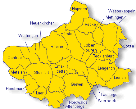
| District STEINFURT on the map of Germany (Source: Wikipedia) |
District STEINFURT on the map of North Rhine-Westphalia (Source: Wikipedia) |
|||||||||||
|
||||||||||||
|
||||||||||||
| Locations in the District STEINFURT (Source: Wikipedia) |
||||||||||||


| The following Ortsregister contains all places of the "Geschichtlichen Orts-Verzeichnisses" (GOV) of CompGen in STEINFURT. By activating the individual buttons in the four columns >Topo<, >SLUB<, >GOV< and >Meyers<, the geographical location of a place can be called up on a map from the geographical OpenTopoMap and Kartenforum or the place descriptions in the GOV-Ortsverzeichnis and Meyers Gazetteer. | ||||||||||||||||||||||||||
| A | B | C | D | E | F | G | H | I | J | K | L | M | N | O | P | Q | R | S | T | U | V | W | X | Y | Z | |
| Location | Distict | Location Typ | Coordinates | Topo | SLUB | GOV | Meyers | Community affiliation |
| Aa | Steinfurt | Farming Community |  |
 |
Wettringen | |||
| Aabauerschaft | Steinfurt | Farming Community | 52.0661 N 007.3638 E |  |
 |
|
|
Laer |
| Aabauerschaft | Steinfurt | Farming Community | 52.3500 N 007.6200 E | |
|
|
|
Hopsten |
| Aatal | Steinfurt | Residential Area | 52.0700 N 007.6000 E | |
|
|
|
Greven |
| Adick | Steinfurt | Farmstead | 52.3760 N 007.6570 E | |
|
|
|
Hopsten |
| Aechterhoek | Steinfurt | Place | 52.1800 N 007.4800 E | |
|
|
|
Emsdetten |
| Ahaus | Steinfurt | District | 52.4000 N 007.6700 E | |
|
|
|
Hopsten |
| Ahaus | Steinfurt | Place | 52.3200 N 007.5800 E | |
|
|
|
Hörstel |
| Ahlert | Steinfurt | Place | 52.1800 N 007.2800 E | |
|
|
|
Ochtrup |
| Ahlert | Steinfurt | Farmstead | 52.2500 N 007.8300 E | |
|
|
|
Westerkappeln |
| Ahlintel | Steinfurt | Farming Community | 52.1300 N 007.4700 E | |
|
|
|
Emsdetten |
| Ahmann | Steinfurt | Building | 52.2330 N 007.6917 E | |
|
|
|
Ibbenbüren |
| Ahmann | Steinfurt | Farmstead | 52.2700 N 007.8500 E | |
|
|
|
Westerkappeln |
| Ahmann | Steinfurt | District | 52.1700 N 007.7800 E | |
|
|
|
Lengerich (Westfalen) |
| Ahmann | Steinfurt | Place | 52.2200 N 007.6800 E | |
|
|
|
Ibbenbüren |
| Ahrendt | Steinfurt | District | 52.2300 N 007.2500 E | |
|
|
|
Wettringen |
| Akamp | Steinfurt | District | 52.4000 N 007.6000 E | |
|
|
|
Hopsten |
| Albermann | Steinfurt | Farmstead | 52.3270 N 007.7980 E | |
|
|
|
Mettingen |
| Albermann | Steinfurt | Place | 52.2800 N 007.6200 E | |
|
|
|
Hörstel |
| Albers | Steinfurt | District | 52.2300 N 007.5300 E | |
|
|
|
Rheine |
| Aldrup | Steinfurt | Farming Community | 52.0700 N 007.6100 E | |
|
|
|
Greven |
| Aldrup | Steinfurt | Farming Community | 52.1300 N 007.9700 E | |
|
|
|
Lienen |
| Aldrup | Steinfurt | Farming Community | 52.1800 N 007.8200 E | |
|
|
|
Lengerich (Westfalen) |
| Alf | Steinfurt | District | 52.2800 N 007.3500 E | |
|
|
|
Neuenkirchen |
| Alfert | Steinfurt | District | 52.1300 N 007.1800 E | |
|
|
|
Metelen |
| Alfing-Teepe | Steinfurt | Farmstead | 52.2700 N 007.8500 E | |
|
|
|
Westerkappeln |
| Alsdorf | Steinfurt | Church Village | 50.8800 N 006.1700 E | |
|
|
|
Alsdorf |
| Alst | Steinfurt | Farming Community | 52.0980 N 007.3240 E | |
|
|
|
Horstmar |
| Alstedde | Steinfurt | Farming Community | 52.2700 N 007.7300 E | |
|
|
|
Ibbenbüren |
| Alstedde/Schafberg | Steinfurt | City Subdistrict | 52.2800 N 007.7500 E | |
|
|
|
Ibbenbüren |
| Altebornholt | Steinfurt | Farmstead | 52.3290 N 007.7390 E | |
|
|
|
Mettingen |
| Alteepping | Steinfurt | Place | 52.2200 N 007.1500 E | |
|
|
|
Ochtrup |
| Alteepping | Steinfurt | Place | 52.3200 N 007.5300 E | |
|
|
|
Hörstel |
| Alte-Holtmann | Steinfurt | Place | 52.2500 N 007.1500 E | |
|
|
|
Ochtrup |
| Altemühle | Steinfurt | District | 52.1300 N 007.1800 E | |
|
|
|
Metelen |
| Altenberge | Steinfurt | Village | 52.0466 N 007.4657 E | |
|
|
|
Altenberge |
| Altenburg | Steinfurt | Farming Community | 52.0500 N 007.3000 E | |
|
|
|
Laer |
| Altenrheine | Steinfurt | District | 52.3000 N 007.4700 E | |
|
|
|
Rheine |
| Altermeyer | Steinfurt | Place | 52.2800 N 007.6000 E | |
|
|
|
Hörstel |
| Altevogt | Steinfurt | District | 52.2000 N 007.7500 E | |
|
|
|
Lengerich (Westfalen) |
| Althelmig | Steinfurt | Place | 52.3300 N 007.5700 E | |
|
|
|
Hörstel |
| Altmann | Steinfurt | Farmstead | 52.3000 N 007.8500 E | |
|
|
|
Westerkappeln |
| Altmann | Steinfurt | Farmstead | 52.3300 N 007.5700 E | |
|
|
|
Hopsten |
| Ambergen | Steinfurt | Farming Community | 52.3000 N 007.7700 E | |
|
|
|
Mettingen |
| Ambrock | Steinfurt | District | 51.3200 N 007.5000 E | |
|
|
|
Hagen |
| Ameling | Steinfurt | District | 52.4000 N 007.6800 E | |
|
|
|
Hopsten |
| Ameling | Steinfurt | District | 52.4000 N 007.6800 E | |
|
|
|
Hopsten |
| Andorf | Steinfurt | Farming Community | 52.2200 N 007.3200 E | |
|
|
|
Wettringen |
| Antekoje | Steinfurt | District | 52.2700 N 007.3500 E | |
|
|
|
Neuenkirchen |
| Antemann | Steinfurt | District | 52.2300 N 007.3700 E | |
|
|
|
Neuenkirchen |
| Antrup | Steinfurt | Farming Community | 52.1700 N 007.8000 E | |
|
|
|
Lengerich (Westfalen) |
| Arendröwer | Steinfurt | Place | 52.2500 N 007.8800 E | |
|
|
|
Lotte |
| Arning | Steinfurt | District | 52.1700 N 007.3000 E | |
|
|
|
Steinfurt |
| Arning-Knufmann | Steinfurt | District | 52.1700 N 007.2700 E | |
|
|
|
Steinfurt |
| Arns | Steinfurt | Place | 52.2200 N 007.1500 E | |
|
|
|
Ochtrup |
| Aschebrock | Steinfurt | District | 52.2300 N 007.8200 E | |
|
|
|
Tecklenburg |
| Athmer | Steinfurt | District | 52.4300 N 007.6200 E | |
|
|
|
Hopsten |
| Athmer | Steinfurt | District | 52.4300 N 007.6200 E | |
|
|
|
Hopsten |
| Attermeyer | Steinfurt | Place | 52.2700 N 007.8000 E | |
|
|
|
Ibbenbüren |
| Aufderhaar-Lagemann | Steinfurt | District | 52.1800 N 007.7500 E | |
|
|
|
Lengerich (Westfalen) |
| Aulkemeyer | Steinfurt | Farmstead | 52.3210 N 007.7960 E | |
|
|
|
Mettingen |
| Austum | Steinfurt | Farming Community | 52.1500 N 007.5700 E | |
|
|
|
Emsdetten |
| Averbeck | Steinfurt | Place | 52.1800 N 007.2500 E | |
|
|
|
Ochtrup |
| Averbeck | Steinfurt | District | 52.2200 N 007.7200 E | |
|
|
|
Tecklenburg |
| Averesch | Steinfurt | Place | 52.3000 N 007.5800 E | |
|
|
|
Hörstel |
| Averwerser | Steinfurt | Farmstead | 52.2800 N 007.8300 E | |
|
|
|
Westerkappeln |
| Averwerser | Steinfurt | Place | 52.3100 N 007.9300 E | |
|
|
|
Lotte |
| Location | Distict | Location Typ | Coordinates | Topo | SLUB | GOV | Meyers | Community affiliation |
| Baar | Steinfurt | Farmstead | 52.3290 N 007.6225 E | |
|
|
|
Ibbenbüren |
| Backmann | Steinfurt | District | 52.2700 N 007.3800 E | |
|
|
|
Neuenkirchen |
| Badelt | Steinfurt | Farmstead | 52.2800 N 007.8300 E | |
|
|
|
Westerkappeln |
| Bahlinghorst | Steinfurt | Place | 52.1800 N 007.2200 E | |
|
|
|
Ochtrup |
| Ballmann | Steinfurt | District | 52.4500 N 007.5800 E | |
|
|
|
Hopsten |
| Ballmann | Steinfurt | District | 52.4500 N 007.5800 E | |
|
|
|
Hopsten |
| Balzer | Steinfurt | Place | 52.2700 N 007.9200 E | |
|
|
|
Lotte |
| Banning | Steinfurt | District | 52.2300 N 007.3300 E | |
|
|
|
Neuenkirchen |
| Banning | Steinfurt | District | 52.2000 N 007.3300 E | |
|
|
|
Wettringen |
| Bartels | Steinfurt | Place | 52.3000 N 007.9200 E | |
|
|
|
Lotte |
| Bärtels | Steinfurt | Place | 52.2500 N 007.7200 E | |
|
|
|
Ibbenbüren |
| Bärtels | Steinfurt | Place | 52.3000 N 007.6500 E | |
|
|
|
Ibbenbüren |
| Barthel | Steinfurt | District | 52.3700 N 007.6200 E | |
|
|
|
Hopsten |
| Barthel | Steinfurt | District | 52.3700 N 007.6200 E | |
|
|
|
Hopsten |
| Bäumer | Steinfurt | District | 52.1500 N 007.3300 E | |
|
|
|
Steinfurt |
| Bäumer | Steinfurt | Farmstead | 52.4027 N 007.6010 E | |
|
|
|
Hopsten |
| Bäumer | Steinfurt | District | 52.4000 N 007.5800 E | |
|
|
|
Hopsten |
| Bäumer | Steinfurt | District | 52.2000 N 007.7300 E | |
|
|
|
Tecklenburg |
| Baumkamp | Steinfurt | District | 52.2000 N 007.7500 E | |
|
|
|
Tecklenburg |
| Becker | Steinfurt | District | 52.3300 N 007.8700 E | |
|
|
|
Westerkappeln |
| Becker | Steinfurt | District | 52.2000 N 007.3700 E | |
|
|
|
Neuenkirchen |
| Becker | Steinfurt | District | 52.1500 N 007.3000 E | |
|
|
|
Steinfurt |
| Beckgerd | Steinfurt | District | 52.1700 N 007.2700 E | |
|
|
|
Steinfurt |
| Beckmann | Steinfurt | District | 52.4200 N 007.6500 E | |
|
|
|
Hopsten |
| Beckmann | Steinfurt | Farmstead | 52.0700 N 007.3800 E | |
|
|
|
Laer |
| Beckmann | Steinfurt | District | 52.2000 N 007.4800 E | |
|
|
|
Rheine |
| Beckmann | Steinfurt | Place | 52.2800 N 007.6300 E | |
|
|
|
Hörstel |
| Beckmann | Steinfurt | Farmstead | 52.3200 N 007.8700 E | |
|
|
|
Westerkappeln |
| Beckmann | Steinfurt | District | 52.4200 N 007.6500 E | |
|
|
|
Hopsten |
| Beckonert | Steinfurt | Farmstead | 52.2006 N 007.5303 E | |
|
|
|
Emsdetten |
| Beiderwellen | Steinfurt | Farmstead | 52.3000 N 007.8800 E | |
|
|
|
Westerkappeln |
| Beiderwellen | Steinfurt | Place | 52.3000 N 007.9200 E | |
|
|
|
Lotte |
| Beimdiek | Steinfurt | Farmstead | 52.3200 N 007.8500 E | |
|
|
|
Westerkappeln |
| Bente | Steinfurt | Farmstead | 52.3000 N 007.8700 E | |
|
|
|
Westerkappeln |
| Bentlage | Steinfurt | Farming Community | 52.2800 N 007.4000 E | |
|
|
|
Rheine |
| Berckemeyer | Steinfurt | District | 52.2000 N 007.7300 E | |
|
|
|
Tecklenburg |
| Berentelg | Steinfurt | Farming Community | 52.3200 N 007.7700 E | |
|
|
|
Mettingen |
| Berg | Steinfurt | District | 52.2000 N 007.7200 E | |
|
|
|
Tecklenburg |
| Berg | Steinfurt | Place | 52.2000 N 007.7000 E | |
|
|
|
Ibbenbüren |
| Bergeshövede | Steinfurt | Farming Community | 52.2800 N 007.6000 E | |
|
|
|
Hörstel |
| Berghaus | Steinfurt | District | 52.3300 N 007.6500 E | |
|
|
|
Ibbenbüren |
| Berghaus | Steinfurt | Farmstead | 52.2156 N 007.6984 E | |
|
|
|
Ibbenbüren |
| Bergmeier | Steinfurt | Farmstead | 52.3210 N 007.7283 E | |
|
|
|
Ibbenbüren |
| Bergschneider | Steinfurt | Place | 52.2800 N 007.7200 E | |
|
|
|
Ibbenbüren |
| Bergstraße | Steinfurt | Farming Community | 52.4300 N 007.5800 E | |
|
|
|
Hopsten |
| Bergstraße | Steinfurt | District | 52.4300 N 007.5800 E | |
|
|
|
Hopsten |
| Berkenhüsen | Steinfurt | District | 52.4300 N 007.6500 E | |
|
|
|
Hopsten |
| Berkenhüsen | Steinfurt | District | 52.4300 N 007.6500 E | |
|
|
|
Hopsten |
| Berlage | Steinfurt | District | 52.2000 N 007.2800 E | |
|
|
|
Wettringen |
| Berlage | Steinfurt | District | 52.3700 N 007.6700 E | |
|
|
|
Recke |
| Berlemann | Steinfurt | Farmstead | 52.2131 N 007.6957 E | |
|
|
|
Ibbenbüren |
| Berninghoff | Steinfurt | District | 52.2300 N 007.4200 E | |
|
|
|
Rheine |
| Bertels | Steinfurt | District | 52.2700 N 007.3700 E | |
|
|
|
Neuenkirchen |
| Bertels-Wieching | Steinfurt | District | 52.2700 N 007.3500 E | |
|
|
|
Neuenkirchen |
| Bertlingen | Steinfurt | District | 52.4500 N 007.6300 E | |
|
|
|
Hopsten |
| Bertlingen | Steinfurt | Farming Community | 52.4500 N 007.6300 E | |
|
|
|
Hopsten |
| Bethesda Klinik | Steinfurt | District | 52.1960 N 007.8529 E | |
|
|
|
Lengerich (Westfalen) |
| Bettendorf | Steinfurt | Village | 50.8865 N 006.2022 E | |
|
|
|
Alsdorf |
| Bettmann | Steinfurt | District | 52.2300 N 007.2500 E | |
|
|
|
Wettringen |
| Beulting | Steinfurt | District | 52.2000 N 007.7300 E | |
|
|
|
Tecklenburg |
| Bevergern | Steinfurt | City Subdistrict | |
|
Hörstel | |||
| Bevergern | Steinfurt | City Subdistrict | 52.2700 N 007.5800 E | |
|
|
|
Hörstel |
| Beyer | Steinfurt | Farmstead | 52.3500 N 007.8200 E | |
|
|
|
Westerkappeln |
| Biecker | Steinfurt | District | 52.1700 N 007.3200 E | |
|
|
|
Steinfurt |
| Bierbaum | Steinfurt | Place | 52.2200 N 007.1800 E | |
|
|
|
Ochtrup |
| Biesenbach | Steinfurt | District | 52.4300 N 007.6800 E | |
|
|
|
Hopsten |
| Bietendüvel | Steinfurt | Place | 52.3000 N 007.7500 E | |
|
|
|
Mettingen |
| Bifang | Steinfurt | District | 52.2000 N 007.3300 E | |
|
|
|
Wettringen |
| Bifang-Diesen | Steinfurt | District | 52.2000 N 007.3300 E | |
|
|
|
Wettringen |
| Bilk | Steinfurt | Farming Community | 52.2300 N 007.2800 E | |
|
|
|
Wettringen |
| Birgte | Steinfurt | Farming Community | 52.2300 N 007.6500 E | |
|
|
|
Hörstel |
| Birke | Steinfurt | Place | 52.3200 N 007.7000 E | |
|
|
|
Ibbenbüren |
| Birkenkämper | Steinfurt | District | 52.3000 N 007.8800 E | |
|
|
|
Westerkappeln |
| Bischof | Steinfurt | District | 52.2500 N 007.8300 E | |
|
|
|
Tecklenburg |
| Bischoff | Steinfurt | Place | 52.3000 N 007.7200 E | |
|
|
|
Ibbenbüren |
| Bischoff | Steinfurt | District | 52.2000 N 007.3200 E | |
|
|
|
Wettringen |
| Blanke | Steinfurt | District | 52.2500 N 007.4000 E | |
|
|
|
Neuenkirchen |
| Bleichen | Steinfurt | Place | 52.1580 N 007.5360 E | |
|
|
|
Emsdetten |
| Blom | Steinfurt | Place | 52.2500 N 007.8000 E | |
|
|
|
Ibbenbüren |
| Blome | Steinfurt | Place | 52.2500 N 007.7500 E | |
|
|
|
Ibbenbüren |
| Blom-Feldmann | Steinfurt | District | 52.2300 N 007.8000 E | |
|
|
|
Tecklenburg |
| Blömker | Steinfurt | District | 52.1700 N 007.7800 E | |
|
|
|
Lengerich (Westfalen) |
| Böckenholt | Steinfurt | Farmstead | 52.3500 N 007.5700 E | |
|
|
|
Hopsten |
| Bocker | Steinfurt | District | 52.1500 N 007.3000 E | |
|
|
|
Steinfurt |
| Bocketal | Steinfurt | Place | 52.2300 N 007.7300 E | |
|
|
|
Tecklenburg |
| Bockholt | Steinfurt | District | 52.2200 N 007.5200 E | |
|
|
|
Rheine |
| Bockholt | Steinfurt | Farming Community | 52.0500 N 007.6800 E | |
|
|
|
Greven |
| Böckmann | Steinfurt | Farmstead | 52.2398 N 007.6824 E | |
|
|
|
Ibbenbüren |
| Bockraden | Steinfurt | City Subdistrict | 52.3200 N 007.7200 E | |
|
|
|
Ibbenbüren |
| Bödding | Steinfurt | Farmstead | 52.0700 N 007.3800 E | |
|
|
|
Laer |
| Boeckemeyer | Steinfurt | Farmstead | 52.3227 N 007.7306 E | |
|
|
|
Ibbenbüren |
| Bögel-Freude | Steinfurt | Place | 52.2300 N 007.7700 E | |
|
|
|
Ibbenbüren |
| Böggemann-Husmann | Steinfurt | Place | 52.2700 N 007.9300 E | |
|
|
|
Lotte |
| Bohle | Steinfurt | Place | 52.2700 N 007.7300 E | |
|
|
|
Ibbenbüren |
| Böhle | Steinfurt | Place | 52.3100 N 007.9300 E | |
|
|
|
Lotte |
| Bohne | Steinfurt | Place | 52.3000 N 007.6500 E | |
|
|
|
Ibbenbüren |
| Böhner | Steinfurt | Place | 52.2800 N 007.6200 E | |
|
|
|
Hörstel |
| Bökenkötter | Steinfurt | District | 52.4000 N 007.6800 E | |
|
|
|
Hopsten |
| Bölk | Steinfurt | Farmstead | 52.3200 N 007.8500 E | |
|
|
|
Westerkappeln |
| Bolle | Steinfurt | District | 52.2200 N 007.2500 E | |
|
|
|
Wettringen |
| Bömer | Steinfurt | District | 52.2200 N 007.2500 E | |
|
|
|
Wettringen |
| Borchelt | Steinfurt | Place | 52.3200 N 007.7800 E | |
|
|
|
Mettingen |
| Borchert | Steinfurt | Farmstead | 52.3800 N 007.5800 E | |
|
|
|
Hopsten |
| Bordieck | Steinfurt | District | 52.1700 N 007.3300 E | |
|
|
|
Steinfurt |
| Börger | Steinfurt | Residential Area | 52.1990 N 007.5200 E | |
|
|
|
Emsdetten |
| Borghorst | Steinfurt | Village | 52.1000 N 007.3700 E | |
|
|
|
Steinfurt |
| Borgmann | Steinfurt | Farmstead | 52.3200 N 007.8200 E | |
|
|
|
Westerkappeln |
| Borgmann | Steinfurt | Place | 52.3000 N 007.9200 E | |
|
|
|
Lotte |
| Börnebrink | Steinfurt | Farming Community | 52.3700 N 007.5700 E | |
|
|
|
Hopsten |
| Börnebrink | Steinfurt | District | 52.3700 N 007.5700 E | |
|
|
|
Hopsten |
| Bossemeyer | Steinfurt | District | 52.1800 N 007.8000 E | |
|
|
|
Lengerich (Westfalen) |
| Bothorn | Steinfurt | Place | 52.2000 N 007.2500 E | |
|
|
|
Ochtrup |
| Brackemeyer | Steinfurt | District | 52.2300 N 007.8000 E | |
|
|
|
Tecklenburg |
| Brandherm | Steinfurt | Place | 52.2800 N 007.6200 E | |
|
|
|
Hörstel |
| Bras | Steinfurt | District | 52.4200 N 007.6000 E | |
|
|
|
Hopsten |
| Brebaum | Steinfurt | District | 52.2200 N 007.2800 E | |
|
|
|
Wettringen |
| Brechte | Steinfurt | Farming Community | 52.2300 N 007.2500 E | |
|
|
|
Wettringen |
| Breckweg | Steinfurt | Place | 52.2700 N 007.7000 E | |
|
|
|
Ibbenbüren |
| Breckweg | Steinfurt | District | 52.3300 N 007.6300 E | |
|
|
|
Recke |
| Bredeweg | Steinfurt | District | 52.4300 N 007.6300 E | |
|
|
|
Hopsten |
| Breischen | Steinfurt | Farming Community | 52.3500 N 007.5700 E | |
|
|
|
Hopsten |
| Brenningmeier | Steinfurt | Place | 52.2800 N 007.7700 E | |
|
|
|
Mettingen |
| Bresch | Steinfurt | District | 52.3800 N 007.6200 E | |
|
|
|
Hopsten |
| Breulmann | Steinfurt | Place | 52.3000 N 007.5300 E | |
|
|
|
Rheine |
| Brink | Steinfurt | District | 52.1800 N 007.7300 E | |
|
|
|
Lengerich (Westfalen) |
| Brink | Steinfurt | District | 52.2200 N 007.3700 E | |
|
|
|
Neuenkirchen |
| Brinkenkämper | Steinfurt | Place | 52.2500 N 007.9200 E | |
|
|
|
Lotte |
| Brinker | Steinfurt | District | 52.2700 N 007.3700 E | |
|
|
|
Neuenkirchen |
| Brinkhus | Steinfurt | Farmstead | 52.3700 N 007.5700 E | |
|
|
|
Hopsten |
| Brinkmann | Steinfurt | Farmstead | 52.3000 N 007.8000 E | |
|
|
|
Westerkappeln |
| Brinkmann | Steinfurt | Place | 52.2500 N 007.8200 E | |
|
|
|
Ibbenbüren |
| Brinkmann | Steinfurt | Farmstead | 52.3500 N 007.6300 E | |
|
|
|
Hopsten |
| Brinkmann | Steinfurt | Place | 52.1800 N 007.2200 E | |
|
|
|
Metelen |
| Brinkschmidt | Steinfurt | Place | 52.2000 N 007.2500 E | |
|
|
|
Ochtrup |
| Brochtrup | Steinfurt | Farming Community | 52.2300 N 007.4400 E | |
|
|
|
Rheine |
| Brockmann | Steinfurt | District | 52.2300 N 007.4300 E | |
|
|
|
Rheine |
| Brockmann | Steinfurt | District | 52.1800 N 007.7700 E | |
|
|
|
Lengerich (Westfalen) |
| Brockmann | Steinfurt | Place | 52.2800 N 007.7200 E | |
|
|
|
Ibbenbüren |
| Brockmeier | Steinfurt | District | 52.1800 N 007.8000 E | |
|
|
|
Lengerich (Westfalen) |
| Brockmeyer | Steinfurt | Place | 52.3000 N 007.7200 E | |
|
|
|
Ibbenbüren |
| Brockmöller | Steinfurt | Farmstead | 52.3800 N 007.6200 E | |
|
|
|
Hopsten |
| Bröker | Steinfurt | Place | 52.1700 N 007.2300 E | |
|
|
|
Metelen |
| Bröker | Steinfurt | District | 52.1700 N 007.2200 E | |
|
|
|
Metelen |
| Brökers Hügel | Steinfurt | District | 52.1000 N 007.3800 E | |
|
|
|
Steinfurt |
| Brokhaar | Steinfurt | District | 52.2000 N 007.4300 E | |
|
|
|
Neuenkirchen |
| Brömmelkamp | Steinfurt | District | 52.4500 N 007.6000 E | |
|
|
|
Hopsten |
| Brönstrup | Steinfurt | District | 52.2500 N 007.8000 E | |
|
|
|
Tecklenburg |
| Bronswick | Steinfurt | Place | 52.3000 N 007.6300 E | |
|
|
|
Ibbenbüren |
| Bronswick | Steinfurt | Place | 52.2800 N 007.6700 E | |
|
|
|
Ibbenbüren |
| Brörmann | Steinfurt | Place | 52.3300 N 007.8000 E | |
|
|
|
Mettingen |
| Bruch | Steinfurt | Farming Community | 52.3500 N 007.7700 E | |
|
|
|
Mettingen |
| Brüffer | Steinfurt | Place | 52.2000 N 007.1000 E | |
|
|
|
Ochtrup |
| Brüffer-Leuster | Steinfurt | Place | 52.2000 N 007.1000 E | |
|
|
|
Ochtrup |
| Brügge | Steinfurt | District | 52.2300 N 007.7500 E | |
|
|
|
Tecklenburg |
| Brügge | Steinfurt | Place | 52.3000 N 007.6800 E | |
|
|
|
Ibbenbüren |
| Brüggemann | Steinfurt | District | 52.4200 N 007.6500 E | |
|
|
|
Hopsten |
| Brüggemann | Steinfurt | District | 52.2200 N 007.3800 E | |
|
|
|
Neuenkirchen |
| Brüggenkamp | Steinfurt | Place | 52.2000 N 007.2300 E | |
|
|
|
Ochtrup |
| Bründermann | Steinfurt | Place | 52.2300 N 007.1200 E | |
|
|
|
Ochtrup |
| Brünemeyer | Steinfurt | District | 52.1800 N 007.7800 E | |
|
|
|
Lengerich (Westfalen) |
| Brünen | Steinfurt | District | 52.2200 N 007.2500 E | |
|
|
|
Wettringen |
| Brünen | Steinfurt | District | 52.2000 N 007.3700 E | |
|
|
|
Neuenkirchen |
| Brüning | Steinfurt | Place | 52.2000 N 007.2300 E | |
|
|
|
Ochtrup |
| Brüning | Steinfurt | District | 52.2300 N 007.2300 E | |
|
|
|
Wettringen |
| Brüning | Steinfurt | Place | 52.3000 N 007.9200 E | |
|
|
|
Lotte |
| Brunn-Schulte-Wissing | Steinfurt | District | 52.2800 N 007.4200 E | |
|
|
|
Rheine |
| Bruns | Steinfurt | Place | 52.3000 N 007.5800 E | |
|
|
|
Hörstel |
| Bruns | Steinfurt | Farmstead | 52.3700 N 007.6500 E | |
|
|
|
Hopsten |
| Brunsing | Steinfurt | Farmstead | 52.3500 N 007.5700 E | |
|
|
|
Hopsten |
| Büchter | Steinfurt | Place | 52.2800 N 007.6500 E | |
|
|
|
Hörstel |
| Bücker | Steinfurt | Place | 52.3300 N 007.7500 E | |
|
|
|
Mettingen |
| Bücker | Steinfurt | District | 52.3800 N 007.6200 E | |
|
|
|
Hopsten |
| Budde | Steinfurt | Farmstead | 52.3995 N 007.5935 E | |
|
|
|
Hopsten |
| Buddemeyer | Steinfurt | District | 52.3200 N 007.8300 E | |
|
|
|
Westerkappeln |
| Buddenberg | Steinfurt | Farmstead | 52.3200 N 007.8500 E | |
|
|
|
Westerkappeln |
| Buddenkuhl | Steinfurt | District | 52.1700 N 007.7700 E | |
|
|
|
Lengerich (Westfalen) |
| Budke | Steinfurt | District | 52.2300 N 007.8700 E | |
|
|
|
Tecklenburg |
| Budke | Steinfurt | District | 52.1800 N 007.7800 E | |
|
|
|
Lengerich (Westfalen) |
| Budke-Beckemeier | Steinfurt | Place | 52.2500 N 007.9000 E | |
|
|
|
Lotte |
| Bügener | Steinfurt | Place | 52.2200 N 007.1300 E | |
|
|
|
Ochtrup |
| Bulk | Steinfurt | Place | 52.3200 N 007.7200 E | |
|
|
|
Ibbenbüren |
| Bulk | Steinfurt | Farmstead | 52.2800 N 007.8300 E | |
|
|
|
Westerkappeln |
| Bulk | Steinfurt | Place | 52.2700 N 007.9300 E | |
|
|
|
Lotte |
| Bullenwiese | Steinfurt | Farmstead | 52.3000 N 007.8200 E | |
|
|
|
Westerkappeln |
| Bültbrune | Steinfurt | Place | 52.2000 N 007.1000 E | |
|
|
|
Ochtrup |
| Bülter | Steinfurt | District | 52.2300 N 007.4500 E | |
|
|
|
Rheine |
| Bünemann | Steinfurt | Farmstead | 52.2800 N 007.8300 E | |
|
|
|
Westerkappeln |
| Büngershammer | Steinfurt | Residential Area | 51.2145 N 007.1651 E | |
|
|
|
Wuppertal |
| Büning | Steinfurt | Place | 52.2000 N 007.1300 E | |
|
|
|
Ochtrup |
| Bünker | Steinfurt | District | 52.4500 N 007.5800 E | |
|
|
|
Hopsten |
| Bunte | Steinfurt | District | 52.1700 N 007.3300 E | |
|
|
|
Steinfurt |
| Büren | Steinfurt | Place | 52.3069 N 007.9721 E | |
|
|
|
Lotte |
| Burgsteinfurt | Steinfurt | District | 52.1500 N 007.3300 E | |
|
|
|
Steinfurt |
| Burrichter | Steinfurt | Place | 52.3200 N 007.7700 E | |
|
|
|
Mettingen |
| Büscher | Steinfurt | Farmstead | 52.3500 N 007.8500 E | |
|
|
|
Westerkappeln |
| Büscher | Steinfurt | Place | 52.3200 N 007.8000 E | |
|
|
|
Mettingen |
| Büscher | Steinfurt | District | 52.4200 N 007.6500 E | |
|
|
|
Hopsten |
| Buschkamp | Steinfurt | District | 52.1300 N 007.1800 E | |
|
|
|
Metelen |
| Bußmann | Steinfurt | Farmstead | 52.2700 N 007.8300 E | |
|
|
|
Westerkappeln |
| Bußmann | Steinfurt | Place | 52.3200 N 007.7500 E | |
|
|
|
Mettingen |
| Bußmann | Steinfurt | District | 52.3300 N 007.7200 E | |
|
|
|
Recke |
| Bußmann | Steinfurt | Place | 52.2500 N 007.7200 E | |
|
|
|
Ibbenbüren |
| Bußmann | Steinfurt | District | 52.2000 N 007.7200 E | |
|
|
|
Tecklenburg |
| Bussmann | Steinfurt | Place | 52.2500 N 007.6300 E | |
|
|
|
Hörstel |
| Bussmann | Steinfurt | District | 52.1300 N 007.1800 E | |
|
|
|
Metelen |
| Location | Distict | Location Typ | Coordinates | Topo | SLUB | GOV | Meyers | Community affiliation |
| Campante | Steinfurt | District | 52.1300 N 007.1800 E | |
|
|
|
Metelen |
| Catenhorn | Steinfurt | Farming Community | 52.2300 N 007.4200 E | |
|
|
|
Rheine |
| Cijzelski | Steinfurt | District | 52.1800 N 007.7500 E | |
|
|
|
Lengerich (Westfalen) |
| Clemenshafen | Steinfurt | District | 52.1800 N 007.4000 E | |
|
|
|
Neuenkirchen |
| Commende | Steinfurt | District | 52.1300 N 007.3300 E | |
|
|
|
Steinfurt |
| Cordes | Steinfurt | District | 52.2500 N 007.8700 E | |
|
|
|
Tecklenburg |
| Cramer | Steinfurt | Place | 52.3200 N 007.5800 E | |
|
|
|
Hörstel |
| Crespel-Deiters | Steinfurt | Place | 52.2700 N 007.7000 E | |
|
|
|
Ibbenbüren |
| Cyrull | Steinfurt | Farmstead | 52.3300 N 007.8500 E | |
|
|
|
Westerkappeln |
| Location | Distict | Location Typ | Coordinates | Topo | SLUB | GOV | Meyers | Community affiliation |
| Dahlmann | Steinfurt | Place | 52.2000 N 007.1300 E | |
|
|
|
Ochtrup |
| Dalhoff | Steinfurt | District | 52.1800 N 007.8200 E | |
|
|
|
Lengerich (Westfalen) |
| Danebrock | Steinfurt | Farming Community | 52.2500 N 007.8300 E | |
|
|
|
Tecklenburg |
| Daniel | Steinfurt | District | 52.2200 N 007.7500 E | |
|
|
|
Tecklenburg |
| Dasbeck | Steinfurt | Farming Community | 51.7200 N 007.8200 E | |
|
|
|
Hamm |
| Dasmann | Steinfurt | District | 52.2200 N 007.7200 E | |
|
|
|
Tecklenburg |
| Daßmann | Steinfurt | Farmstead | 52.2136 N 007.6904 E | |
|
|
|
Ibbenbüren |
| Dassmann | Steinfurt | District | 52.4200 N 007.6300 E | |
|
|
|
Hopsten |
| Deepe | Steinfurt | Place | 52.2500 N 007.8300 E | |
|
|
|
Ibbenbüren |
| Deilen | Steinfurt | District | 52.2300 N 007.2800 E | |
|
|
|
Wettringen |
| Deiters | Steinfurt | Place | 52.2800 N 007.6200 E | |
|
|
|
Hörstel |
| Deiters | Steinfurt | District | 52.3200 N 007.4500 E | |
|
|
|
Rheine |
| Deitert | Steinfurt | District | 52.1500 N 007.3200 E | |
|
|
|
Steinfurt |
| Delsen | Steinfurt | District | 52.2800 N 007.4200 E | |
|
|
|
Rheine |
| Demandt | Steinfurt | Place | 52.2000 N 007.1000 E | |
|
|
|
Ochtrup |
| Demmler | Steinfurt | Farmstead | 52.2800 N 007.9000 E | |
|
|
|
Westerkappeln |
| Determeyer | Steinfurt | District | 52.2800 N 007.4500 E | |
|
|
|
Rheine |
| Deupmann | Steinfurt | District | 52.2300 N 007.4500 E | |
|
|
|
Rheine |
| Devesfeld | Steinfurt | District | 52.2800 N 007.3800 E | |
|
|
|
Rheine |
| Dickenberg | Steinfurt | City Subdistrict | 52.3000 N 007.6500 E | |
|
|
|
Ibbenbüren |
| Dieckenberg | Steinfurt | Place | |
|
Ibbenbüren | |||
| Dieckmann | Steinfurt | District | 52.3200 N 007.8200 E | |
|
|
|
Westerkappeln |
| Dieckmann | Steinfurt | Residential Area | 52.2054 N 007.5245 E | |
|
|
|
Emsdetten |
| Dieckmann | Steinfurt | District | 52.1800 N 007.8700 E | |
|
|
|
Lengerich (Westfalen) |
| Diekamp | Steinfurt | Farmstead | 52.3000 N 007.8500 E | |
|
|
|
Westerkappeln |
| Diekmann | Steinfurt | District | 52.2000 N 007.7300 E | |
|
|
|
Tecklenburg |
| Diekmann | Steinfurt | District | 52.2800 N 007.9300 E | |
|
|
|
Lotte |
| Diekschwegmann | Steinfurt | Place | 52.3000 N 007.9200 E | |
|
|
|
Lotte |
| Dierkes | Steinfurt | Farmstead | 52.3235 N 007.6322 E | |
|
|
|
Ibbenbüren |
| Dierkes | Steinfurt | Place | 52.2700 N 007.5700 E | |
|
|
|
Hörstel |
| Dierkes | Steinfurt | Place | 52.3500 N 007.7700 E | |
|
|
|
Mettingen |
| Dierkes | Steinfurt | Place | 52.3200 N 007.6200 E | |
|
|
|
Ibbenbüren |
| Dierksmeier | Steinfurt | District | 52.2000 N 007.7200 E | |
|
|
|
Tecklenburg |
| Diersmann | Steinfurt | Farmstead | 52.3300 N 007.8500 E | |
|
|
|
Westerkappeln |
| Diese | Steinfurt | District | 52.1700 N 007.3000 E | |
|
|
|
Steinfurt |
| Dießenbacher | Steinfurt | Place | 52.2700 N 007.6700 E | |
|
|
|
Ibbenbüren |
| Dillhof | Steinfurt | Place | 52.2700 N 007.6500 E | |
|
|
|
Ibbenbüren |
| Dinkhoff | Steinfurt | Place | 52.2200 N 007.2000 E | |
|
|
|
Ochtrup |
| Dirkes | Steinfurt | Farmstead | 52.3200 N 007.7300 E | |
|
|
|
Ibbenbüren |
| Dirks | Steinfurt | District | 52.2300 N 007.2300 E | |
|
|
|
Wettringen |
| Dirting | Steinfurt | Farmstead | 52.2018 N 007.5353 E | |
|
|
|
Emsdetten |
| Dohe | Steinfurt | District | 52.2000 N 007.7300 E | |
|
|
|
Tecklenburg |
| Dohe | Steinfurt | District | 52.1800 N 007.7700 E | |
|
|
|
Lengerich (Westfalen) |
| Döhlemeyer | Steinfurt | Place | 52.2300 N 007.9000 E | |
|
|
|
Lotte |
| Döker | Steinfurt | Place | 52.3200 N 007.6200 E | |
|
|
|
Ibbenbüren |
| Dölemeyer | Steinfurt | Farmstead | 52.3200 N 007.8200 E | |
|
|
|
Westerkappeln |
| Dolle | Steinfurt | Place | 52.1700 N 007.1700 E | |
|
|
|
Ochtrup |
| Donnerberg | Steinfurt | Place | 52.3200 N 007.9500 E | |
|
|
|
Lotte |
| Dorenkamp | Steinfurt | District | 52.2700 N 007.4000 E | |
|
|
|
Rheine |
| Dörenthe | Steinfurt | City Subdistrict | 52.2200 N 007.6800 E | |
|
|
|
Ibbenbüren |
| Dowidat | Steinfurt | District | 52.1700 N 007.7800 E | |
|
|
|
Lengerich (Westfalen) |
| Dräger | Steinfurt | District | 52.3700 N 007.5800 E | |
|
|
|
Hopsten |
| Drees | Steinfurt | District | 52.2200 N 007.7200 E | |
|
|
|
Tecklenburg |
| Dreierwalde | Steinfurt | City Subdistrict | |
|
Hörstel | |||
| Dreierwalde | Steinfurt | Farming Community | 52.3300 N 007.5000 E | |
|
|
|
Hörstel |
| Dreising | Steinfurt | District | 52.4000 N 007.6800 E | |
|
|
|
Hopsten |
| Drerup | Steinfurt | District | 52.2300 N 007.3700 E | |
|
|
|
Neuenkirchen |
| Dresemann | Steinfurt | District | 52.2500 N 007.8300 E | |
|
|
|
Tecklenburg |
| Dresselhaus | Steinfurt | District | 52.4500 N 007.6200 E | |
|
|
|
Hopsten |
| Dresselhaus | Steinfurt | District | 52.4500 N 007.6200 E | |
|
|
|
Hopsten |
| Dresselhausen | Steinfurt | Farming Community | 52.4500 N 007.6200 E | |
|
|
|
Hopsten |
| Dresselhausen | Steinfurt | District | 52.4500 N 007.6200 E | |
|
|
|
Hopsten |
| Dreyer | Steinfurt | Place | 52.2700 N 007.9300 E | |
|
|
|
Lotte |
| Driemeyer | Steinfurt | Farmstead | 52.3000 N 007.8300 E | |
|
|
|
Westerkappeln |
| Droste | Steinfurt | Farmstead | 52.3969 N 007.5961 E | |
|
|
|
Hopsten |
| Drymeier | Steinfurt | District | 52.3300 N 007.8800 E | |
|
|
|
Westerkappeln |
| Dudeck | Steinfurt | District | 52.1700 N 007.3200 E | |
|
|
|
Steinfurt |
| Duesmann | Steinfurt | Place | 52.2300 N 007.1200 E | |
|
|
|
Ochtrup |
| Dumte | Steinfurt | Farming Community | 52.1000 N 007.3500 E | |
|
|
|
Steinfurt |
| Düte | Steinfurt | Farming Community | 52.2700 N 007.8700 E | |
|
|
|
Westerkappeln |
| Dutum | Steinfurt | Farming Community | 52.2500 N 007.4000 E | |
|
|
|
Neuenkirchen |
| Dyk | Steinfurt | Place | 52.2700 N 007.6700 E | |
|
|
|
Ibbenbüren |
| Location | Distict | Location Typ | Coordinates | Topo | SLUB | GOV | Meyers | Community affiliation |
| Ebbeler | Steinfurt | Place | 52.2500 N 007.6500 E | |
|
|
|
Hörstel |
| Ebbeler | Steinfurt | Place | 52.3000 N 007.6500 E | |
|
|
|
Ibbenbüren |
| Eberhard | Steinfurt | District | 52.4500 N 007.6000 E | |
|
|
|
Hopsten |
| Echterhoff | Steinfurt | Farmstead | 52.2700 N 007.8800 E | |
|
|
|
Westerkappeln |
| Echtermeyer | Steinfurt | District | 52.4000 N 007.6700 E | |
|
|
|
Hopsten |
| Egbert | Steinfurt | District | 52.1800 N 007.7700 E | |
|
|
|
Lengerich (Westfalen) |
| Egbert | Steinfurt | Place | 52.2700 N 007.6700 E | |
|
|
|
Ibbenbüren |
| Egelkamp | Steinfurt | Place | 52.2500 N 007.7200 E | |
|
|
|
Ibbenbüren |
| Eidermann | Steinfurt | Farmstead | 52.3500 N 007.8800 E | |
|
|
|
Westerkappeln |
| Eilers | Steinfurt | Place | 52.2000 N 007.2300 E | |
|
|
|
Ochtrup |
| Eilers | Steinfurt | District | 52.2700 N 007.5300 E | |
|
|
|
Rheine |
| Eilting | Steinfurt | District | 52.1300 N 007.1800 E | |
|
|
|
Metelen |
| Eismann | Steinfurt | District | 52.2939 N 007.8213 E | |
|
|
|
Westerkappeln |
| Eithoff | Steinfurt | Place | 52.2000 N 007.2500 E | |
|
|
|
Ochtrup |
| Elfering | Steinfurt | Place | 52.1800 N 007.2500 E | |
|
|
|
Ochtrup |
| Elfering | Steinfurt | District | 52.2000 N 007.7300 E | |
|
|
|
Tecklenburg |
| Elfers | Steinfurt | District | 52.1700 N 007.3000 E | |
|
|
|
Steinfurt |
| Elfers-Hemker | Steinfurt | District | 52.1700 N 007.3300 E | |
|
|
|
Steinfurt |
| Elfring | Steinfurt | District | 52.4500 N 007.6300 E | |
|
|
|
Hopsten |
| Elingmann | Steinfurt | Place | 52.2000 N 007.2500 E | |
|
|
|
Ochtrup |
| Elingmann-Kauling | Steinfurt | Place | 52.1800 N 007.2300 E | |
|
|
|
Metelen |
| Elisenhof | Steinfurt | Place | 52.3300 N 007.5700 E | |
|
|
|
Hörstel |
| Elisenhöhe | Steinfurt | Place | 51.2500 N 007.1700 E | |
|
|
|
Wuppertal |
| Elling | Steinfurt | District | 52.2200 N 007.3200 E | |
|
|
|
Wettringen |
| Elseck | Steinfurt | Place | 52.2800 N 007.5800 E | |
|
|
|
Hörstel |
| Elte | Steinfurt | Place | 52.2300 N 007.5200 E | |
|
|
|
Rheine |
| Emsdetten | Steinfurt | City Subdistrict | |
|
Emsdetten | |||
| Emsdetten, Rathaus | Steinfurt | Building | 52.1735 N 007.5292 E | |
|
|
|
Emsdetten |
| Engbert | Steinfurt | District | 52.2000 N 007.7200 E | |
|
|
|
Tecklenburg |
| Engbrink | Steinfurt | District | 52.1700 N 007.2800 E | |
|
|
|
Steinfurt |
| Engel | Steinfurt | Place | 52.2800 N 007.7500 E | |
|
|
|
Mettingen |
| Engelbert | Steinfurt | District | 52.1800 N 007.7300 E | |
|
|
|
Lengerich (Westfalen) |
| Engels | Steinfurt | Place | 52.1800 N 007.2500 E | |
|
|
|
Ochtrup |
| Engelshove | Steinfurt | Place | 52.2500 N 007.6200 E | |
|
|
|
Hörstel |
| Enning | Steinfurt | District | 52.1300 N 007.1800 E | |
|
|
|
Metelen |
| Entrup | Steinfurt | Farming Community | 52.0500 N 007.4800 E | |
|
|
|
Altenberge |
| Epker | Steinfurt | District | 52.1700 N 007.3200 E | |
|
|
|
Steinfurt |
| Eppert-Hungermann | Steinfurt | Place | 52.2800 N 007.6800 E | |
|
|
|
Ibbenbüren |
| Erke | Steinfurt | District | 52.3000 N 007.8700 E | |
|
|
|
Westerkappeln |
| Erlich | Steinfurt | District | 52.2200 N 007.2500 E | |
|
|
|
Wettringen |
| Ermke | Steinfurt | Place | 52.2500 N 007.2000 E | |
|
|
|
Ochtrup |
| Ernsting | Steinfurt | District | 52.2300 N 007.4200 E | |
|
|
|
Rheine |
| Erpenstein | Steinfurt | Place | 52.2300 N 007.7300 E | |
|
|
|
Tecklenburg |
| Erpenstein-Wunsch | Steinfurt | District | 52.2300 N 007.8000 E | |
|
|
|
Tecklenburg |
| Esch | Steinfurt | Farming Community | 52.4300 N 007.6300 E | |
|
|
|
Hopsten |
| Esch | Steinfurt | District | 52.2200 N 007.8300 E | |
|
|
|
Tecklenburg |
| Eschendorf | Steinfurt | Farming Community | 52.2700 N 007.4700 E | |
|
|
|
Rheine |
| Esch-Osterfinke | Steinfurt | District | 52.4300 N 007.6300 E | |
|
|
|
Hopsten |
| Esmann | Steinfurt | District | 52.1800 N 007.8000 E | |
|
|
|
Lengerich (Westfalen) |
| Espel | Steinfurt | District | 52.3300 N 007.7300 E | |
|
|
|
Recke |
| Essing | Steinfurt | District | 52.2700 N 007.3700 E | |
|
|
|
Neuenkirchen |
| Evers | Steinfurt | Place | 52.1800 N 007.2200 E | |
|
|
|
Metelen |
| Ewering | Steinfurt | Place | 52.1700 N 007.2500 E | |
|
|
|
Ochtrup |
| Ewers | Steinfurt | District | 52.3200 N 007.8300 E | |
|
|
|
Westerkappeln |
| Exler | Steinfurt | Place | 52.3000 N 007.5500 E | |
|
|
|
Hörstel |
| Exler | Steinfurt | District | 52.3800 N 007.6000 E | |
|
|
|
Hopsten |
| Exler | Steinfurt | District | 52.2300 N 007.4200 E | |
|
|
|
Rheine |
| Exterheide | Steinfurt | Place | |
|
Lengerich (Westfalen) | |||
| Eying | Steinfurt | Farmstead | 52.3300 N 007.5700 E | |
|
|
|
Hopsten |
| Location | Distict | Location Typ | Coordinates | Topo | SLUB | GOV | Meyers | Community affiliation |
| Fabry | Steinfurt | District | 52.2200 N 007.3300 E | |
|
|
|
Wettringen |
| Fahrtbruch | Steinfurt | District | 52.2500 N 007.8500 E | |
|
|
|
Westerkappeln |
| Fark | Steinfurt | District | 52.2200 N 007.4300 E | |
|
|
|
Rheine |
| Fasselt-Stermann | Steinfurt | District | 52.2200 N 007.7200 E | |
|
|
|
Tecklenburg |
| Fechtel | Steinfurt | Place | 52.3200 N 007.7000 E | |
|
|
|
Ibbenbüren |
| Fehlker | Steinfurt | District | 52.2200 N 007.2700 E | |
|
|
|
Wettringen |
| Feistmann | Steinfurt | District | 52.2200 N 007.4500 E | |
|
|
|
Rheine |
| Feldbauerschaft | Steinfurt | District | 52.0800 N 007.4500 E | |
|
|
|
Nordwalde |
| Feldevert | Steinfurt | Place | 52.2300 N 007.1700 E | |
|
|
|
Ochtrup |
| Feldgen | Steinfurt | Place | 50.8500 N 006.1200 E | |
|
|
|
Herzogenrath |
| Feldhaus | Steinfurt | District | 52.3800 N 007.6200 E | |
|
|
|
Hopsten |
| Feldhaus | Steinfurt | Place | 52.2800 N 007.6200 E | |
|
|
|
Hörstel |
| Feldherm | Steinfurt | District | 52.2200 N 007.2500 E | |
|
|
|
Wettringen |
| Feldhues | Steinfurt | Place | 52.1800 N 007.1000 E | |
|
|
|
Heek |
| Feldhus | Steinfurt | District | 52.1200 N 007.3200 E | |
|
|
|
Horstmar |
| Feldkamp | Steinfurt | District | 52.2000 N 007.3300 E | |
|
|
|
Wettringen |
| Feldkamp | Steinfurt | District | 52.4300 N 007.5800 E | |
|
|
|
Hopsten |
| Feldkamp | Steinfurt | District | 52.1700 N 007.3000 E | |
|
|
|
Steinfurt |
| Feldkante | Steinfurt | District | 52.2300 N 007.5300 E | |
|
|
|
Rheine |
| Feldmann | Steinfurt | Place | 52.3200 N 007.8000 E | |
|
|
|
Mettingen |
| Feldmann | Steinfurt | Farmstead | 52.3700 N 007.5800 E | |
|
|
|
Hopsten |
| Feldmann | Steinfurt | Place | 52.3200 N 007.5500 E | |
|
|
|
Hörstel |
| Feldmann | Steinfurt | Farmstead | 52.2046 N 007.5212 E | |
|
|
|
Emsdetten |
| Feldmann-Zurlinden | Steinfurt | District | 52.3800 N 007.6200 E | |
|
|
|
Hopsten |
| Feldmark | Steinfurt | District | 52.2100 N 007.8200 E | |
|
|
|
Tecklenburg |
| Feldmark | Steinfurt | District | 52.1500 N 007.8200 E | |
|
|
|
Lengerich (Westfalen) |
| Feldmeyer | Steinfurt | District | 52.2300 N 007.8200 E | |
|
|
|
Tecklenburg |
| Feldschulten | Steinfurt | Place | 52.2000 N 007.1000 E | |
|
|
|
Ochtrup |
| Fernrodde | Steinfurt | District | 52.2700 N 007.5300 E | |
|
|
|
Rheine |
| Fernströning | Steinfurt | District | 52.2000 N 007.3300 E | |
|
|
|
Wettringen |
| Fiedler | Steinfurt | Farmstead | 52.3500 N 007.5800 E | |
|
|
|
Hopsten |
| Fiedler | Steinfurt | District | 52.2300 N 007.5000 E | |
|
|
|
Rheine |
| Fiegenbaum | Steinfurt | District | 52.1800 N 007.7800 E | |
|
|
|
Lengerich (Westfalen) |
| Fieth | Steinfurt | District | 52.2300 N 007.5500 E | |
|
|
|
Rheine |
| Finke | Steinfurt | District | 52.4300 N 007.6000 E | |
|
|
|
Hopsten |
| Finke-Epker | Steinfurt | District | 52.1700 N 007.3200 E | |
|
|
|
Steinfurt |
| Finke-Hardbecke | Steinfurt | District | 52.4300 N 007.6500 E | |
|
|
|
Hopsten |
| Finke-Lageschulte | Steinfurt | District | 52.4300 N 007.6000 E | |
|
|
|
Hopsten |
| Finke-Landwehr | Steinfurt | District | 52.4300 N 007.6000 E | |
|
|
|
Hopsten |
| Finke-Rawie | Steinfurt | Place | 52.3000 N 007.9300 E | |
|
|
|
Lotte |
| Finke-Schulte | Steinfurt | District | 52.4300 N 007.6000 E | |
|
|
|
Hopsten |
| Finkmann | Steinfurt | Place | 52.2800 N 007.5800 E | |
|
|
|
Hörstel |
| Fischer | Steinfurt | Farmstead | 52.3800 N 007.6000 E | |
|
|
|
Hopsten |
| Fislage | Steinfurt | District | 52.2000 N 007.4200 E | |
|
|
|
Neuenkirchen |
| Fislage | Steinfurt | Place | 52.3200 N 007.5800 E | |
|
|
|
Hörstel |
| Floer | Steinfurt | District | 52.1500 N 007.3000 E | |
|
|
|
Steinfurt |
| Flöer | Steinfurt | District | 52.1700 N 007.3300 E | |
|
|
|
Steinfurt |
| Flögemann | Steinfurt | District | 52.1300 N 007.3200 E | |
|
|
|
Steinfurt |
| Flüßmeyer | Steinfurt | Farmstead | 52.3200 N 007.8200 E | |
|
|
|
Westerkappeln |
| Focke | Steinfurt | Place | 52.2000 N 007.2500 E | |
|
|
|
Ochtrup |
| Follenbröcker | Steinfurt | Place | 52.2000 N 007.2300 E | |
|
|
|
Ochtrup |
| Forsthaus Habichtswald | Steinfurt | District | 52.2300 N 007.8700 E | |
|
|
|
Tecklenburg |
| Foullois | Steinfurt | Place | 52.3000 N 007.7200 E | |
|
|
|
Ibbenbüren |
| Franke | Steinfurt | Place | 52.2000 N 007.2300 E | |
|
|
|
Ochtrup |
| Freermann | Steinfurt | Place | 52.2300 N 007.1300 E | |
|
|
|
Ochtrup |
| Freese | Steinfurt | Farmstead | 52.3500 N 007.9000 E | |
|
|
|
Westerkappeln |
| Freese | Steinfurt | District | 52.4500 N 007.6200 E | |
|
|
|
Hopsten |
| Frehe | Steinfurt | Farmstead | 52.3216 N 007.7182 E | |
|
|
|
Ibbenbüren |
| Frehe Knuf | Steinfurt | Place | 52.3200 N 007.7800 E | |
|
|
|
Mettingen |
| Frehe-Siermann | Steinfurt | Place | 52.3200 N 007.7800 E | |
|
|
|
Mettingen |
| Frehmeyer | Steinfurt | Farmstead | 52.2800 N 007.9000 E | |
|
|
|
Westerkappeln |
| Freie | Steinfurt | District | 52.4500 N 007.6200 E | |
|
|
|
Hopsten |
| Freie Meiners | Steinfurt | District | 52.4200 N 007.6200 E | |
|
|
|
Hopsten |
| Freiseis | Steinfurt | Place | 52.3000 N 007.5500 E | |
|
|
|
Hörstel |
| Frekers | Steinfurt | District | 52.3700 N 007.6700 E | |
|
|
|
Recke |
| Fremeyer | Steinfurt | Farmstead | 52.3700 N 007.8800 E | |
|
|
|
Westerkappeln |
| Freude | Steinfurt | District | 52.2000 N 007.7500 E | |
|
|
|
Tecklenburg |
| Freude | Steinfurt | Place | 52.3000 N 007.8000 E | |
|
|
|
Mettingen |
| Freude-Waltermann | Steinfurt | Place | 52.2700 N 007.7500 E | |
|
|
|
Ibbenbüren |
| Friedenau | Steinfurt | District | 52.1500 N 007.3200 E | |
|
|
|
Steinfurt |
| Frische | Steinfurt | Place | 52.3000 N 007.5300 E | |
|
|
|
Hörstel |
| Frohoff-Hülsmann | Steinfurt | District | 52.2000 N 007.3200 E | |
|
|
|
Wettringen |
| Fromme | Steinfurt | District | 52.2200 N 007.5000 E | |
|
|
|
Rheine |
| Frye | Steinfurt | District | 52.2500 N 007.8200 E | |
|
|
|
Tecklenburg |
| Fuestrup | Steinfurt | Farming Community | 52.0300 N 007.6800 E | |
|
|
|
Greven |
| Funke | Steinfurt | Place | 52.2500 N 007.6300 E | |
|
|
|
Hörstel |
| Location | Distict | Location Typ | Coordinates | Topo | SLUB | GOV | Meyers | Community affiliation |
| Garmann | Steinfurt | District | 52.4200 N 007.6500 E | |
|
|
|
Hopsten |
| Garmann | Steinfurt | Place | 52.2800 N 007.5800 E | |
|
|
|
Hörstel |
| Gastmann | Steinfurt | Place | 52.2700 N 007.9300 E | |
|
|
|
Lotte |
| Gauxmann | Steinfurt | Place | 52.1800 N 007.1300 E | |
|
|
|
Ochtrup |
| Gauxmann | Steinfurt | District | 52.1500 N 007.2500 E | |
|
|
|
Metelen |
| Gebbe | Steinfurt | Place | 52.3000 N 007.5700 E | |
|
|
|
Hörstel |
| Gebing | Steinfurt | Place | 52.3200 N 007.5500 E | |
|
|
|
Hörstel |
| Geesmann | Steinfurt | Place | 52.2700 N 007.7700 E | |
|
|
|
Ibbenbüren |
| Geest Wiele | Steinfurt | Farmstead | 52.2800 N 007.8800 E | |
|
|
|
Westerkappeln |
| Geest-Albrecht | Steinfurt | Place | 52.2700 N 007.9300 E | |
|
|
|
Lotte |
| Gehling | Steinfurt | District | 52.2000 N 007.4800 E | |
|
|
|
Rheine |
| Gehling | Steinfurt | District | 52.2300 N 007.5200 E | |
|
|
|
Rheine |
| Gehring | Steinfurt | District | 52.2200 N 007.5000 E | |
|
|
|
Rheine |
| Gellendorf | Steinfurt | Farming Community | 52.2600 N 007.4800 E | |
|
|
|
Rheine |
| Genhausen | Steinfurt | District | 51.1500 N 006.3300 E | |
|
|
|
Mönchengladbach |
| Genhülsen | Steinfurt | District | 51.1500 N 006.3800 E | |
|
|
|
Mönchengladbach |
| Gentrup | Steinfurt | Farmstead | 52.2700 N 007.8300 E | |
|
|
|
Westerkappeln |
| Gerdener | Steinfurt | District | 52.1700 N 007.3300 E | |
|
|
|
Steinfurt |
| Gerdes | Steinfurt | Farmstead | 52.3500 N 007.5800 E | |
|
|
|
Hopsten |
| Gering | Steinfurt | Place | 52.2000 N 007.2500 E | |
|
|
|
Ochtrup |
| Gerling | Steinfurt | Place | 52.3000 N 007.5300 E | |
|
|
|
Hörstel |
| Gersemann | Steinfurt | Place | 52.3000 N 007.7000 E | |
|
|
|
Ibbenbüren |
| Gersmeier | Steinfurt | District | 52.2200 N 007.7200 E | |
|
|
|
Tecklenburg |
| Gertaudenhof | Steinfurt | Place | 52.3000 N 007.8200 E | |
|
|
|
Mettingen |
| Gesenberg | Steinfurt | District | 52.3200 N 007.8300 E | |
|
|
|
Westerkappeln |
| Gilde | Steinfurt | Place | 52.3200 N 007.8000 E | |
|
|
|
Mettingen |
| Gillhaus | Steinfurt | Place | 52.3300 N 007.7500 E | |
|
|
|
Mettingen |
| Gimbte | Steinfurt | Village | 52.0500 N 007.6500 E | |
|
|
|
Greven |
| Gimbte | Steinfurt | Locality | |
|
Greven | |||
| Glinsfort | Steinfurt | Place | 52.2500 N 007.9000 E | |
|
|
|
Lotte |
| Göcke | Steinfurt | District | 52.4000 N 007.6800 E | |
|
|
|
Hopsten |
| Gödecker | Steinfurt | Farmstead | 52.2500 N 007.8500 E | |
|
|
|
Westerkappeln |
| Goecke | Steinfurt | District | 52.3700 N 007.6700 E | |
|
|
|
Recke |
| Gohfeld | Steinfurt | Place | 52.2700 N 007.9300 E | |
|
|
|
Lotte |
| Goldbeck | Steinfurt | Place | 52.2700 N 007.7200 E | |
|
|
|
Ibbenbüren |
| Goldlüke | Steinfurt | Place | 52.2700 N 007.9300 E | |
|
|
|
Lotte |
| Goldmeyer | Steinfurt | Farmstead | 52.2800 N 007.8800 E | |
|
|
|
Westerkappeln |
| Gößling | Steinfurt | District | 52.4200 N 007.6700 E | |
|
|
|
Hopsten |
| Gravenhorst | Steinfurt | Farming Community | 52.2800 N 007.6200 E | |
|
|
|
Hörstel |
| Greimering | Steinfurt | Place | 52.3200 N 007.7000 E | |
|
|
|
Ibbenbüren |
| Greiwe | Steinfurt | District | 52.2000 N 007.7300 E | |
|
|
|
Tecklenburg |
| Greiwe | Steinfurt | Farmstead | 52.3500 N 007.6200 E | |
|
|
|
Hopsten |
| Greiwe | Steinfurt | District | 52.1500 N 007.3000 E | |
|
|
|
Steinfurt |
| Greiwe | Steinfurt | Place | 52.2800 N 007.5800 E | |
|
|
|
Hörstel |
| Gremme-Averkamp | Steinfurt | Place | 52.2500 N 007.6200 E | |
|
|
|
Hörstel |
| Greß | Steinfurt | District | 52.3800 N 007.6200 E | |
|
|
|
Hopsten |
| Grevenkemper | Steinfurt | Farmstead | 52.3700 N 007.9000 E | |
|
|
|
Westerkappeln |
| Grewe | Steinfurt | Place | 52.3000 N 007.8000 E | |
|
|
|
Mettingen |
| Grewe | Steinfurt | Farmstead | 52.3051 N 007.7318 E | |
|
|
|
Ibbenbüren |
| Grewe | Steinfurt | District | 52.4000 N 007.6500 E | |
|
|
|
Hopsten |
| Griese | Steinfurt | Farmstead | 52.2700 N 007.8300 E | |
|
|
|
Westerkappeln |
| Griesen | Steinfurt | District | 52.3500 N 007.5700 E | |
|
|
|
Hopsten |
| Grolle | Steinfurt | Place | 52.3000 N 007.5800 E | |
|
|
|
Hörstel |
| Grone | Steinfurt | Place | 52.2700 N 007.7000 E | |
|
|
|
Ibbenbüren |
| Grönemann | Steinfurt | Farmstead | 52.2800 N 007.8200 E | |
|
|
|
Westerkappeln |
| Gröpper | Steinfurt | Place | 52.2700 N 007.6300 E | |
|
|
|
Hörstel |
| Groß Staden | Steinfurt | Farming Community | 52.3900 N 007.6200 E | |
|
|
|
Hopsten |
| Grotegerd | Steinfurt | Place | 52.1800 N 007.1200 E | |
|
|
|
Heek |
| Grothaus | Steinfurt | District | 52.4200 N 007.6500 E | |
|
|
|
Hopsten |
| Grothaus | Steinfurt | Place | 52.3500 N 007.7800 E | |
|
|
|
Mettingen |
| Grothaus | Steinfurt | Farmstead | 52.3500 N 007.8700 E | |
|
|
|
Westerkappeln |
| Grothmann | Steinfurt | District | 52.2500 N 007.8000 E | |
|
|
|
Tecklenburg |
| Grothus | Steinfurt | District | 52.1700 N 007.3300 E | |
|
|
|
Steinfurt |
| Grotke | Steinfurt | District | 52.2700 N 007.3700 E | |
|
|
|
Neuenkirchen |
| Grotke | Steinfurt | District | 52.2000 N 007.4500 E | |
|
|
|
Rheine |
| Grove | Steinfurt | Place | 52.3000 N 007.7200 E | |
|
|
|
Ibbenbüren |
| Grundmann | Steinfurt | Farmstead | 52.3500 N 007.8200 E | |
|
|
|
Westerkappeln |
| Grüter | Steinfurt | District | 52.2000 N 007.7300 E | |
|
|
|
Tecklenburg |
| Grüter-Herding | Steinfurt | Place | 52.1700 N 007.1800 E | |
|
|
|
Ochtrup |
| Gude | Steinfurt | District | 52.2800 N 007.5300 E | |
|
|
|
Rheine |
| Gude | Steinfurt | Farmstead | 52.3000 N 007.8300 E | |
|
|
|
Westerkappeln |
| Guderian | Steinfurt | Place | 52.3500 N 007.7800 E | |
|
|
|
Mettingen |
| Guhe | Steinfurt | Place | 52.3000 N 007.7000 E | |
|
|
|
Ibbenbüren |
| Guntrup | Steinfurt | Farming Community | 52.0700 N 007.6700 E | |
|
|
|
Greven |
| Gut Brechte | Steinfurt | District | 52.2500 N 007.2500 E | |
|
|
|
Wettringen |
| Gut Laurenz | Steinfurt | Place | 52.1700 N 007.1800 E | |
|
|
|
Ochtrup |
| Gut Velpe | Steinfurt | Estate | 52.2688 N 007.8583 E | |
|
|
|
Westerkappeln |
| Location | Distict | Location Typ | Coordinates | Topo | SLUB | GOV | Meyers | Community affiliation |
| Haake | Steinfurt | Farmstead | 52.3700 N 007.6200 E | |
|
|
|
Hopsten |
| Haar | Steinfurt | District | 52.4500 N 007.6300 E | |
|
|
|
Hopsten |
| Haarhof | Steinfurt | District | 52.3800 N 007.7000 E | |
|
|
|
Recke |
| Haarmann | Steinfurt | District | 52.2200 N 007.2500 E | |
|
|
|
Wettringen |
| Hachmann | Steinfurt | District | 52.1300 N 007.3000 E | |
|
|
|
Horstmar |
| Hackmann | Steinfurt | Place | 52.2800 N 007.7800 E | |
|
|
|
Ibbenbüren |
| Hackmann | Steinfurt | Place | 52.2700 N 007.9000 E | |
|
|
|
Lotte |
| Hadderfeld | Steinfurt | District | 52.3200 N 007.8300 E | |
|
|
|
Westerkappeln |
| Haddorf | Steinfurt | Farming Community | 52.2500 N 007.3200 E | |
|
|
|
Wettringen |
| Haerhof | Steinfurt | Farming Community | |
|
Recke | |||
| Haermeyer | Steinfurt | Place | 52.3200 N 007.6500 E | |
|
|
|
Ibbenbüren |
| Haferland | Steinfurt | Farmstead | 52.3500 N 007.8800 E | |
|
|
|
Westerkappeln |
| Hagedorn | Steinfurt | Place | 52.2700 N 007.7300 E | |
|
|
|
Ibbenbüren |
| Hagedorn | Steinfurt | District | 52.3800 N 007.6200 E | |
|
|
|
Hopsten |
| Hagemann | Steinfurt | Farmstead | 52.3500 N 007.5700 E | |
|
|
|
Hopsten |
| Hagemann | Steinfurt | Place | 52.1800 N 007.2700 E | |
|
|
|
Ochtrup |
| Hagen | Steinfurt | District | 52.4300 N 007.6200 E | |
|
|
|
Hopsten |
| Hagenberg | Steinfurt | Place | 52.2500 N 007.8800 E | |
|
|
|
Lotte |
| Hagenberg | Steinfurt | District | 52.2200 N 007.7300 E | |
|
|
|
Tecklenburg |
| Hagenhoff | Steinfurt | District | 52.2200 N 007.2700 E | |
|
|
|
Wettringen |
| Hagenort | Steinfurt | Place | |
|
Hörstel | |||
| Hagmann | Steinfurt | District | 52.1300 N 007.3000 E | |
|
|
|
Steinfurt |
| Haking-Heitmann | Steinfurt | District | 52.3200 N 007.4300 E | |
|
|
|
Rheine |
| Hakmann | Steinfurt | District | 52.1800 N 007.7800 E | |
|
|
|
Lengerich (Westfalen) |
| Hakmann | Steinfurt | Farmstead | 52.2800 N 007.9000 E | |
|
|
|
Westerkappeln |
| Halen | Steinfurt | Place | 52.3200 N 007.9300 E | |
|
|
|
Lotte |
| Halen | Steinfurt | Place | 52.3300 N 007.9200 E | |
|
|
|
Lotte |
| Halermöller | Steinfurt | Place | 52.3500 N 007.7700 E | |
|
|
|
Mettingen |
| Hälker | Steinfurt | Farmstead | 52.3700 N 007.6300 E | |
|
|
|
Hopsten |
| Halmmer | Steinfurt | District | 52.1500 N 007.3000 E | |
|
|
|
Steinfurt |
| Haltern | Steinfurt | Farming Community | 52.1210 N 007.2735 E | |
|
|
|
Horstmar |
| Halverde | Steinfurt | Village | 52.4200 N 007.6700 E | |
|
|
|
Hopsten |
| Halverde | Steinfurt | Locality | |
|
Hopsten | |||
| Hambrügge | Steinfurt | District | 52.2700 N 007.3800 E | |
|
|
|
Neuenkirchen |
| Hambühren-Handarpe | Steinfurt | Farming Community | |
|
Westerkappeln | |||
| Hambüren | Steinfurt | Farming Community | 52.2700 N 007.8500 E | |
|
|
|
Westerkappeln |
| Handarpe | Steinfurt | Farming Community | 52.2500 N 007.8300 E | |
|
|
|
Westerkappeln |
| Hannekotte | Steinfurt | Place | 52.2300 N 007.1200 E | |
|
|
|
Ochtrup |
| Hanningbrink | Steinfurt | Farmstead | 52.2700 N 007.8700 E | |
|
|
|
Westerkappeln |
| Hansell | Steinfurt | Farming Community | 52.0500 N 007.5300 E | |
|
|
|
Altenberge |
| Harbecke | Steinfurt | District | 52.4500 N 007.6300 E | |
|
|
|
Hopsten |
| Hardbecke | Steinfurt | Farmstead | 52.2700 N 007.8500 E | |
|
|
|
Westerkappeln |
| Harhof | Steinfurt | Farming Community | 52.3800 N 007.6800 E | |
|
|
|
Recke |
| Harkenberg | Steinfurt | Place | 52.2800 N 007.5800 E | |
|
|
|
Hörstel |
| Harpel | Steinfurt | District | 52.4000 N 007.6800 E | |
|
|
|
Hopsten |
| Hartbecke | Steinfurt | District | 52.4300 N 007.6500 E | |
|
|
|
Hopsten |
| Harte | Steinfurt | Farmstead | 52.2700 N 007.8500 E | |
|
|
|
Westerkappeln |
| Harting | Steinfurt | Place | 52.2700 N 007.7300 E | |
|
|
|
Ibbenbüren |
| Hartken | Steinfurt | District | 52.3500 N 007.5800 E | |
|
|
|
Hopsten |
| Harum | Steinfurt | District | 52.2300 N 007.3800 E | |
|
|
|
Neuenkirchen |
| Haselroth | Steinfurt | Place | 52.3000 N 007.6700 E | |
|
|
|
Ibbenbüren |
| Haselroth | Steinfurt | District | 52.2500 N 007.8000 E | |
|
|
|
Tecklenburg |
| Hasselmann | Steinfurt | District | 52.1700 N 007.8200 E | |
|
|
|
Lengerich (Westfalen) |
| Hassink-Schortemeyer | Steinfurt | District | 52.4300 N 007.5800 E | |
|
|
|
Hopsten |
| Hauenhorst | Steinfurt | Farming Community | 52.2300 N 007.4500 E | |
|
|
|
Rheine |
| Haus Alst | Steinfurt | Estate | 52.0932 N 007.3359 E | |
|
|
|
Horstmar |
| Haus Brook | Steinfurt | District | 52.2500 N 007.3500 E | |
|
|
|
Neuenkirchen |
| Haus Cappeln | Steinfurt | Estate | 52.3170 N 007.8749 E | |
|
|
|
Westerkappeln |
| Haus Gloria | Steinfurt | Place | 52.3200 N 007.7500 E | |
|
|
|
Mettingen |
| Haus Grone | Steinfurt | Place | 52.2700 N 007.7000 E | |
|
|
|
Ibbenbüren |
| Haus Gronewald | Steinfurt | Place | 52.2700 N 007.7000 E | |
|
|
|
Ibbenbüren |
| Haus Langenbrück | Steinfurt | Estate | 52.3082 N 007.8176 E | |
|
|
|
Westerkappeln |
| Haus Stöverken | Steinfurt | District | 52.2300 N 007.5000 E | |
|
|
|
Rheine |
| Haus Surenburg | Steinfurt | Place | 52.2700 N 007.6000 E | |
|
|
|
Hörstel |
| Haus Trampenhegge | Steinfurt | District | 52.2300 N 007.4800 E | |
|
|
|
Rheine |
| Haus Veltrup | Steinfurt | District | 52.1200 N 007.3200 E | |
|
|
|
Steinfurt |
| Haus Welbergen | Steinfurt | Place | 52.1800 N 007.2300 E | |
|
|
|
Ochtrup |
| Havermeyer | Steinfurt | Place | 52.3000 N 007.9300 E | |
|
|
|
Lotte |
| Heckmann | Steinfurt | District | 52.2000 N 007.3700 E | |
|
|
|
Neuenkirchen |
| Heckmann | Steinfurt | District | 52.3200 N 007.8300 E | |
|
|
|
Westerkappeln |
| Heeke | Steinfurt | Place | 52.3000 N 007.6700 E | |
|
|
|
Ibbenbüren |
| Heeke | Steinfurt | Place | 52.3300 N 007.5700 E | |
|
|
|
Hörstel |
| Heele-Bökenkötter | Steinfurt | District | 52.4000 N 007.6800 E | |
|
|
|
Hopsten |
| Heerdt | Steinfurt | Farmstead | 52.0700 N 007.3800 E | |
|
|
|
Laer |
| Heewerth | Steinfurt | Farmstead | 52.2800 N 007.8300 E | |
|
|
|
Westerkappeln |
| Heidehof | Steinfurt | District | 52.1403 N 007.2919 E | |
|
|
|
Horstmar |
| Heidehof | Steinfurt | Place | 52.3200 N 007.5300 E | |
|
|
|
Hörstel |
| Heiliges Feld | Steinfurt | Place | 52.3300 N 007.6000 E | |
|
|
|
Ibbenbüren |
| Heiliges Feld | Steinfurt | Place | 52.3300 N 007.5800 E | |
|
|
|
Hörstel |
| Heine | Steinfurt | District | 52.2500 N 007.5000 E | |
|
|
|
Rheine |
| Heinenbernd | Steinfurt | Place | 52.2000 N 007.1000 E | |
|
|
|
Ochtrup |
| Heitkamp | Steinfurt | District | 52.2200 N 007.3500 E | |
|
|
|
Neuenkirchen |
| Heitkemper | Steinfurt | Farmstead | 52.2042 N 007.5097 E | |
|
|
|
Emsdetten |
| Heitkönig | Steinfurt | District | 52.4200 N 007.6500 E | |
|
|
|
Hopsten |
| Helker | Steinfurt | Place | 52.1700 N 007.1700 E | |
|
|
|
Ochtrup |
| Helker | Steinfurt | District | 52.1500 N 007.3000 E | |
|
|
|
Steinfurt |
| Helmer | Steinfurt | Place | 52.2800 N 007.6200 E | |
|
|
|
Hörstel |
| Helmer | Steinfurt | Place | 52.3200 N 007.6200 E | |
|
|
|
Ibbenbüren |
| Helmes | Steinfurt | District | 52.3700 N 007.6700 E | |
|
|
|
Recke |
| Helmich | Steinfurt | Farmstead | 52.3000 N 007.8800 E | |
|
|
|
Westerkappeln |
| Helmig | Steinfurt | District | 52.2000 N 007.7500 E | |
|
|
|
Tecklenburg |
| Helmsing | Steinfurt | Farmstead | 52.3905 N 007.5892 E | |
|
|
|
Hopsten |
| Hembergen | Steinfurt | Farming Community | 52.1300 N 007.5800 E | |
|
|
|
Greven |
| Hembergen | Steinfurt | District | |
|
Emsdetten | |||
| Hembergen | Steinfurt | Village | 52.1300 N 007.6000 E | |
|
|
|
Emsdetten |
| Hembrock | Steinfurt | Place | 52.3000 N 007.5800 E | |
|
|
|
Hörstel |
| Hemker | Steinfurt | District | 52.1500 N 007.3000 E | |
|
|
|
Steinfurt |
| Hemmer | Steinfurt | Farmstead | 52.3300 N 007.8000 E | |
|
|
|
Westerkappeln |
| Hengemühle | Steinfurt | District | 52.3000 N 007.4000 E | |
|
|
|
Rheine |
| Hepe | Steinfurt | District | 52.1700 N 007.2700 E | |
|
|
|
Steinfurt |
| Herbening | Steinfurt | Place | 52.2200 N 007.1700 E | |
|
|
|
Ochtrup |
| Herbern | Steinfurt | Farming Community | 52.1200 N 007.5800 E | |
|
|
|
Greven |
| Hergemöller | Steinfurt | Place | 52.3300 N 007.7300 E | |
|
|
|
Mettingen |
| Herkenhoff | Steinfurt | Place | 52.2274 N 007.6996 E | |
|
|
|
Ibbenbüren |
| Hermann | Steinfurt | Place | 52.3200 N 007.6500 E | |
|
|
|
Ibbenbüren |
| Hermeler | Steinfurt | Place | 52.3000 N 007.6000 E | |
|
|
|
Hörstel |
| Hermes | Steinfurt | Farmstead | 52.3700 N 007.6300 E | |
|
|
|
Hopsten |
| Herzogenrath | Steinfurt | Main Place | 50.8666 N 006.0976 E | |
|
|
|
Herzogenrath |
| Hespeling | Steinfurt | Farmstead | 52.3500 N 007.6300 E | |
|
|
|
Hopsten |
| Hesselmann | Steinfurt | District | 52.2000 N 007.4700 E | |
|
|
|
Rheine |
| Heßling | Steinfurt | District | 52.2700 N 007.3700 E | |
|
|
|
Neuenkirchen |
| Heuing | Steinfurt | Place | 52.2200 N 007.1500 E | |
|
|
|
Ochtrup |
| Hewing | Steinfurt | Place | 52.1800 N 007.1500 E | |
|
|
|
Ochtrup |
| Heying | Steinfurt | Place | 52.1700 N 007.1500 E | |
|
|
|
Ochtrup |
| Hibbe | Steinfurt | District | 52.2700 N 007.5300 E | |
|
|
|
Rheine |
| Hilbers | Steinfurt | District | 52.2300 N 007.3800 E | |
|
|
|
Neuenkirchen |
| Hildebrand | Steinfurt | District | 52.2500 N 007.8300 E | |
|
|
|
Tecklenburg |
| Hilgenhöner | Steinfurt | District | 51.7200 N 007.8200 E | |
|
|
|
Hamm |
| Hillebrand | Steinfurt | Place | 52.2200 N 007.5700 E | |
|
|
|
Rheine |
| Hillen | Steinfurt | Place | 52.2200 N 007.1500 E | |
|
|
|
Ochtrup |
| Hillers | Steinfurt | Place | 52.2500 N 007.1300 E | |
|
|
|
Ochtrup |
| Hilmer | Steinfurt | Place | 52.2000 N 007.6800 E | |
|
|
|
Saerbeck |
| Hils | Steinfurt | Place | 52.1700 N 007.2000 E | |
|
|
|
Ochtrup |
| Hindersmann | Steinfurt | Place | 52.2700 N 007.9200 E | |
|
|
|
Lotte |
| Hinken | Steinfurt | District | 52.3800 N 007.6200 E | |
|
|
|
Hopsten |
| Hinkenlammert | Steinfurt | Place | 52.1700 N 007.1700 E | |
|
|
|
Ochtrup |
| Hinkert | Steinfurt | District | 52.1300 N 007.1800 E | |
|
|
|
Metelen |
| Hinnah | Steinfurt | District | 52.2800 N 007.9200 E | |
|
|
|
Lotte |
| Hinterding | Steinfurt | Place | 52.3000 N 007.5800 E | |
|
|
|
Hörstel |
| Hirschemöller | Steinfurt | Place | 52.3500 N 007.7800 E | |
|
|
|
Mettingen |
| Hischemöller | Steinfurt | Farmstead | 52.3500 N 007.8700 E | |
|
|
|
Westerkappeln |
| Hischemöller | Steinfurt | Farmstead | 52.2800 N 007.8800 E | |
|
|
|
Westerkappeln |
| Höcker | Steinfurt | District | 52.1700 N 007.8200 E | |
|
|
|
Lengerich (Westfalen) |
| Höfen | Steinfurt | Farming Community | 52.4300 N 007.6500 E | |
|
|
|
Hopsten |
| Hoffmeier | Steinfurt | Farmstead | 52.3038 N 007.7242 E | |
|
|
|
Ibbenbüren |
| Hoffrogge | Steinfurt | Farmstead | 52.3500 N 007.5700 E | |
|
|
|
Hopsten |
| Hoge | Steinfurt | District | 52.1300 N 007.3000 E | |
|
|
|
Steinfurt |
| Hoge | Steinfurt | Place | 52.3500 N 007.7700 E | |
|
|
|
Mettingen |
| Hoge | Steinfurt | District | 52.3300 N 007.8000 E | |
|
|
|
Westerkappeln |
| Högemann | Steinfurt | District | 52.2200 N 007.2500 E | |
|
|
|
Wettringen |
| Hohenhorst | Steinfurt | Farming Community | 52.0200 N 007.5000 E | |
|
|
|
Altenberge |
| Hohne | Steinfurt | Farming Community | 52.1500 N 007.8500 E | |
|
|
|
Lengerich (Westfalen) |
| Hohnhorst | Steinfurt | Farmstead | 52.3325 N 007.6400 E | |
|
|
|
Ibbenbüren |
| Hökenjan | Steinfurt | District | 52.1300 N 007.3000 E | |
|
|
|
Horstmar |
| Hollen | Steinfurt | District | 52.4200 N 007.6700 E | |
|
|
|
Hopsten |
| Hollenbeck | Steinfurt | Place | 52.0200 N 007.4700 E | |
|
|
|
Altenberge |
| Hollenberg | Steinfurt | District | 52.2800 N 007.8700 E | |
|
|
|
Westerkappeln |
| Hollenbergs Hügel | Steinfurt | District | 52.2800 N 007.8300 E | |
|
|
|
Westerkappeln |
| Hollich | Steinfurt | Farming Community | 52.1500 N 007.3500 E | |
|
|
|
Steinfurt |
| Holling | Steinfurt | District | 52.3800 N 007.6000 E | |
|
|
|
Hopsten |
| Hollingen | Steinfurt | Farming Community | 52.1300 N 007.5000 E | |
|
|
|
Emsdetten |
| Hollmann | Steinfurt | Farmstead | 52.3300 N 007.8000 E | |
|
|
|
Westerkappeln |
| Holperdorp | Steinfurt | Farming Community | 52.1700 N 007.9700 E | |
|
|
|
Lienen |
| Hölscher | Steinfurt | District | 52.2000 N 007.3700 E | |
|
|
|
Neuenkirchen |
| Hölscher | Steinfurt | Place | 52.2500 N 007.1300 E | |
|
|
|
Ochtrup |
| Hölscher | Steinfurt | District | 52.2000 N 007.3500 E | |
|
|
|
Wettringen |
| Holt | Steinfurt | District | 52.4300 N 007.6300 E | |
|
|
|
Hopsten |
| Hölter | Steinfurt | Farming Community | 52.1200 N 007.7700 E | |
|
|
|
Ladbergen |
| Holtevert | Steinfurt | Place | 52.2000 N 007.2500 E | |
|
|
|
Ochtrup |
| Holtgräwe | Steinfurt | Farmstead | 52.3500 N 007.8800 E | |
|
|
|
Westerkappeln |
| Holthausen | Steinfurt | District | 52.2300 N 007.7500 E | |
|
|
|
Tecklenburg |
| Holthausen | Steinfurt | District | 52.0350 N 007.3800 E | |
|
|
|
Laer |
| Holtkamp | Steinfurt | District | 52.3500 N 007.5800 E | |
|
|
|
Hopsten |
| Holtkamp | Steinfurt | Farmstead | 52.2494 N 007.7729 E | |
|
|
|
Ibbenbüren |
| Holtmann | Steinfurt | District | 52.4000 N 007.6800 E | |
|
|
|
Hopsten |
| Holtmannspötter | Steinfurt | Place | 52.2300 N 007.1500 E | |
|
|
|
Ochtrup |
| Holtwick | Steinfurt | District | 52.1700 N 007.3000 E | |
|
|
|
Steinfurt |
| Holtz | Steinfurt | Place | 52.2500 N 007.5500 E | |
|
|
|
Hörstel |
| Holzhausen (Lienen) | Steinfurt | Farming Community | 52.1200 N 007.9000 E | |
|
|
|
Lienen |
| Homölle | Steinfurt | Place | 52.2500 N 007.1700 E | |
|
|
|
Ochtrup |
| Hoof | Steinfurt | Place | 52.2000 N 007.4800 E | |
|
|
|
Emsdetten |
| Hoppe | Steinfurt | Place | 52.3200 N 007.7200 E | |
|
|
|
Ibbenbüren |
| Hopsten | Steinfurt | Village | 52.3817 N 007.6033 E | |
|
|
|
Hopsten |
| Hopsten | Steinfurt | Locality | |
|
Hopsten | |||
| Horst | Steinfurt | District | 52.2200 N 007.5000 E | |
|
|
|
Rheine |
| Hörst | Steinfurt | Place | 52.1800 N 007.1300 E | |
|
|
|
Ochtrup |
| Hörstel | Steinfurt | City Subdistrict | |
|
Hörstel | |||
| Hörstel | Steinfurt | District | 52.2965 N 007.5859 E | |
|
|
|
Hörstel |
| Hörsteler Bröck | Steinfurt | Place | 52.3200 N 007.5300 E | |
|
|
|
Hörstel |
| Horsthok | Steinfurt | District | 52.1700 N 007.3300 E | |
|
|
|
Steinfurt |
| Horstmann | Steinfurt | Place | 52.3200 N 007.5700 E | |
|
|
|
Hörstel |
| Horstmann | Steinfurt | District | 52.2700 N 007.3700 E | |
|
|
|
Neuenkirchen |
| Horstmann | Steinfurt | District | 52.2200 N 007.7200 E | |
|
|
|
Tecklenburg |
| Horstmar | Steinfurt | District | 52.0810 N 007.3050 E | |
|
|
|
Horstmar |
| Horstmeier | Steinfurt | Farmstead | 52.2700 N 007.8300 E | |
|
|
|
Westerkappeln |
| Höste | Steinfurt | Farming Community | 52.1500 N 007.9200 E | |
|
|
|
Lienen |
| Hövelbernd | Steinfurt | Farmstead | 52.3000 N 007.8800 E | |
|
|
|
Westerkappeln |
| Hövelmeyer | Steinfurt | Farmstead | 52.2453 N 007.7330 E | |
|
|
|
Ibbenbüren |
| Höveringhausen | Steinfurt | Farming Community | 52.2800 N 007.7800 E | |
|
|
|
Mettingen |
| Howe | Steinfurt | District | 52.1700 N 007.8200 E | |
|
|
|
Lengerich (Westfalen) |
| Huesmann | Steinfurt | Place | 52.2500 N 007.7200 E | |
|
|
|
Ibbenbüren |
| Hüging | Steinfurt | Place | 52.1800 N 007.2500 E | |
|
|
|
Ochtrup |
| Hühl | Steinfurt | District | 52.4300 N 007.5800 E | |
|
|
|
Hopsten |
| Huil | Steinfurt | Farmstead | 52.3984 N 007.5928 E | |
|
|
|
Hopsten |
| Hülsken | Steinfurt | Place | 52.1800 N 007.1300 E | |
|
|
|
Ochtrup |
| Hülsmann | Steinfurt | Place | 52.2500 N 007.9200 E | |
|
|
|
Lotte |
| Hülsmann | Steinfurt | Place | 52.2800 N 007.7500 E | |
|
|
|
Ibbenbüren |
| Hülsmann | Steinfurt | District | 52.4200 N 007.6700 E | |
|
|
|
Hopsten |
| Hümmling | Steinfurt | Farming Community | 52.4200 N 007.6200 E | |
|
|
|
Hopsten |
| Hundler | Steinfurt | District | 52.1700 N 007.3200 E | |
|
|
|
Steinfurt |
| Hünefeld | Steinfurt | Place | 52.2800 N 007.8000 E | |
|
|
|
Mettingen |
| Huneke | Steinfurt | Place | 52.2700 N 007.9000 E | |
|
|
|
Lotte |
| Hunsche | Steinfurt | District | 52.1800 N 007.7700 E | |
|
|
|
Lengerich (Westfalen) |
| Hunsche | Steinfurt | Farmstead | 52.3011 N 007.7291 E | |
|
|
|
Ibbenbüren |
| Hunterorth | Steinfurt | Place | 52.3000 N 007.9200 E | |
|
|
|
Lotte |
| Huntmann | Steinfurt | Place | 52.3000 N 007.9300 E | |
|
|
|
Lotte |
| Hüsing | Steinfurt | District | 52.2300 N 007.4300 E | |
|
|
|
Rheine |
| Husmann | Steinfurt | Place | 52.3200 N 007.7200 E | |
|
|
|
Mettingen |
| Hüttrup | Steinfurt | Farming Community | 52.1200 N 007.6700 E | |
|
|
|
Greven |
| Hüwe | Steinfurt | District | 52.2000 N 007.3700 E | |
|
|
|
Neuenkirchen |
| Location | Distict | Location Typ | Coordinates | Topo | SLUB | GOV | Meyers | Community affiliation |
| Ibbenbüren | Steinfurt | City Subdistrict | 52.2791 N 007.7148 E | |
|
|
|
Ibbenbüren |
| Ibbenbüren-Perm | Steinfurt | District | 52.2630 N 007.8340 E | |
|
|
|
Ibbenbüren |
| Im Holtkamp | Steinfurt | Place | 52.1300 N 007.5300 E | |
|
|
|
Emsdetten |
| Intrup | Steinfurt | Farming Community | 52.1700 N 007.8500 E | |
|
|
|
Lengerich (Westfalen) |
| Ipe | Steinfurt | District | 52.2200 N 007.2500 E | |
|
|
|
Wettringen |
| Isendorf | Steinfurt | Farming Community | 52.1800 N 007.5200 E | |
|
|
|
Emsdetten |
| Isinghoff | Steinfurt | Place | 52.2200 N 007.1700 E | |
|
|
|
Ochtrup |
| Location | Distict | Location Typ | Coordinates | Topo | SLUB | GOV | Meyers | Community affiliation |
| Jäger | Steinfurt | District | 52.4500 N 007.6300 E | |
|
|
|
Hopsten |
| Janning | Steinfurt | District | 52.2200 N 007.5500 E | |
|
|
|
Rheine |
| Janning | Steinfurt | Place | 52.3200 N 007.6200 E | |
|
|
|
Ibbenbüren |
| Janning | Steinfurt | District | 52.2200 N 007.3300 E | |
|
|
|
Neuenkirchen |
| Janning | Steinfurt | Place | 52.1700 N 007.2500 E | |
|
|
|
Ochtrup |
| Janning-Grotegerd | Steinfurt | Place | 52.2300 N 007.1300 E | |
|
|
|
Ochtrup |
| Jasper | Steinfurt | District | 52.3800 N 007.6200 E | |
|
|
|
Hopsten |
| Jaspers | Steinfurt | District | 52.3800 N 007.6200 E | |
|
|
|
Hopsten |
| Jochmann | Steinfurt | District | 52.2000 N 007.7200 E | |
|
|
|
Tecklenburg |
| Jochmann | Steinfurt | District | 52.1800 N 007.7700 E | |
|
|
|
Lengerich (Westfalen) |
| Johann to Büren | Steinfurt | Place | 52.3150 N 007.9700 E | |
|
|
|
Lotte |
| Johannemann | Steinfurt | District | 52.3800 N 007.6200 E | |
|
|
|
Hopsten |
| Johanning | Steinfurt | Farmstead | 52.3964 N 007.5909 E | |
|
|
|
Hopsten |
| Johannknecht | Steinfurt | Place | 52.3000 N 007.5500 E | |
|
|
|
Hörstel |
| Jordan | Steinfurt | Place | 52.1800 N 007.2200 E | |
|
|
|
Metelen |
| Josephshaus | Steinfurt | District | 52.1800 N 007.2800 E | |
|
|
|
Wettringen |
| Jostmeier | Steinfurt | Place | 52.2500 N 007.6300 E | |
|
|
|
Hörstel |
| Jostmeier | Steinfurt | District | 52.2000 N 007.7200 E | |
|
|
|
Tecklenburg |
| Junker | Steinfurt | District | 52.1500 N 007.3000 E | |
|
|
|
Steinfurt |
| Jürgens | Steinfurt | District | 52.2700 N 007.3700 E | |
|
|
|
Neuenkirchen |
| Location | Distict | Location Typ | Coordinates | Topo | SLUB | GOV | Meyers | Community affiliation |
| Kahlenborg | Steinfurt | Place | 52.3300 N 007.5000 E | |
|
|
|
Hörstel |
| Kaiser | Steinfurt | Place | 52.3300 N 007.7800 E | |
|
|
|
Mettingen |
| Kajüter | Steinfurt | Place | 52.3000 N 007.5800 E | |
|
|
|
Hörstel |
| Kälberberg | Steinfurt | District | 52.3300 N 007.6500 E | |
|
|
|
Recke |
| Kaldemeyer | Steinfurt | District | 52.2300 N 007.3200 E | |
|
|
|
Wettringen |
| Kaldemeyer | Steinfurt | District | 52.2000 N 007.7300 E | |
|
|
|
Tecklenburg |
| Käller | Steinfurt | Place | 52.3000 N 007.8000 E | |
|
|
|
Mettingen |
| Kämner | Steinfurt | District | 52.4500 N 007.6200 E | |
|
|
|
Hopsten |
| Kamp | Steinfurt | District | 52.3800 N 007.5800 E | |
|
|
|
Hopsten |
| Kamp | Steinfurt | District | 52.3500 N 007.6700 E | |
|
|
|
Recke |
| Kamphus | Steinfurt | Farmstead | 52.3700 N 007.6000 E | |
|
|
|
Hopsten |
| Kamping | Steinfurt | District | 52.1500 N 007.3000 E | |
|
|
|
Steinfurt |
| Kampmeyer | Steinfurt | Farmstead | 52.2800 N 007.8700 E | |
|
|
|
Westerkappeln |
| Kampschmidt-Steingröver | Steinfurt | Place | 52.2500 N 007.7800 E | |
|
|
|
Ibbenbüren |
| Kanalhafen | Steinfurt | Place | |
|
Rheine | |||
| Kappelhoff | Steinfurt | Place | 52.1800 N 007.2500 E | |
|
|
|
Ochtrup |
| Kappelhoff | Steinfurt | District | 52.2300 N 007.3700 E | |
|
|
|
Neuenkirchen |
| Kappelhoff-Kauling | Steinfurt | Place | 52.1800 N 007.2300 E | |
|
|
|
Metelen |
| Karlsburg | Steinfurt | District | 52.2290 N 007.5840 E | |
|
|
|
|
| Käsekamp | Steinfurt | District | 52.2200 N 007.7200 E | |
|
|
|
Tecklenburg |
| Kassling | Steinfurt | Place | 52.2800 N 007.6300 E | |
|
|
|
Hörstel |
| Kätker | Steinfurt | Place | 52.2800 N 007.7500 E | |
|
|
|
Mettingen |
| Kattenvenne | Steinfurt | Farming Community | 52.1000 N 007.8700 E | |
|
|
|
Lienen |
| Kauling | Steinfurt | Place | 52.2000 N 007.2500 E | |
|
|
|
Ochtrup |
| Keeve | Steinfurt | District | 52.4000 N 007.6700 E | |
|
|
|
Hopsten |
| Keller | Steinfurt | Place | 52.3000 N 007.6500 E | |
|
|
|
Ibbenbüren |
| Keller | Steinfurt | Place | 52.3200 N 007.8000 E | |
|
|
|
Mettingen |
| Kemken | Steinfurt | Place | 52.2700 N 007.9300 E | |
|
|
|
Lotte |
| Kemmermann | Steinfurt | Place | 52.2800 N 007.6000 E | |
|
|
|
Hörstel |
| Kemper | Steinfurt | District | 52.1700 N 007.8000 E | |
|
|
|
Lengerich (Westfalen) |
| Kenning | Steinfurt | District | 52.4000 N 007.6700 E | |
|
|
|
Hopsten |
| Kerßen | Steinfurt | Place | 52.2500 N 007.8000 E | |
|
|
|
Ibbenbüren |
| Kiebitzheide | Steinfurt | Place | |
|
Rheine | |||
| Kiewe | Steinfurt | District | 52.2300 N 007.3300 E | |
|
|
|
Wettringen |
| Kipp | Steinfurt | District | 52.2200 N 007.4200 E | |
|
|
|
Rheine |
| Kipp | Steinfurt | District | 52.2000 N 007.7300 E | |
|
|
|
Tecklenburg |
| Kipp | Steinfurt | District | 52.1700 N 007.7800 E | |
|
|
|
Lengerich (Westfalen) |
| Kipp-Oeljeklaus | Steinfurt | District | 52.1800 N 007.7700 E | |
|
|
|
Lengerich (Westfalen) |
| Kirchbauerschaft | Steinfurt | District | 52.0700 N 007.4700 E | |
|
|
|
Nordwalde |
| Kirchhof | Steinfurt | Place | 52.2700 N 007.7700 E | |
|
|
|
Ibbenbüren |
| Kitten | Steinfurt | Place | 52.2800 N 007.6700 E | |
|
|
|
Ibbenbüren |
| Klausmeyer | Steinfurt | Place | 52.3000 N 007.7800 E | |
|
|
|
Mettingen |
| Kleemann-Steingröver | Steinfurt | Place | 52.2700 N 007.8000 E | |
|
|
|
Ibbenbüren |
| Kleier | Steinfurt | District | 52.2200 N 007.7200 E | |
|
|
|
Tecklenburg |
| Kleimann | Steinfurt | Place | 52.2700 N 007.7500 E | |
|
|
|
Ibbenbüren |
| Kleimeier | Steinfurt | Farmstead | 52.2000 N 007.6500 E | |
|
|
|
Saerbeck |
| Klein | Steinfurt | Place | 52.3000 N 007.6700 E | |
|
|
|
Ibbenbüren |
| Klein Haddorf | Steinfurt | Farming Community | 52.2500 N 007.2700 E | |
|
|
|
Wettringen |
| Klein Staden | Steinfurt | Farming Community | 52.3700 N 007.6150 E | |
|
|
|
Hopsten |
| Kleine Donnerberg | Steinfurt | Place | 52.3200 N 007.9500 E | |
|
|
|
Lotte |
| Kleine Stricker | Steinfurt | Farmstead | 52.2280 N 007.7156 E | |
|
|
|
Ibbenbüren |
| Kleine-Harmeyer | Steinfurt | District | 52.3800 N 007.6200 E | |
|
|
|
Hopsten |
| Klingenberg | Steinfurt | Place | 52.3200 N 007.8000 E | |
|
|
|
Mettingen |
| Klinker | Steinfurt | District | 52.1700 N 007.8000 E | |
|
|
|
Lengerich (Westfalen) |
| Klockenkemper | Steinfurt | District | 52.1700 N 007.2300 E | |
|
|
|
Metelen |
| Klodt-Bussmann | Steinfurt | Place | 52.2800 N 007.6500 E | |
|
|
|
Ibbenbüren |
| Klopmeyer | Steinfurt | District | 52.3200 N 007.8500 E | |
|
|
|
Westerkappeln |
| Kloster | Steinfurt | Place | 52.2500 N 007.9000 E | |
|
|
|
Lotte |
| Klostermann | Steinfurt | Place | 52.2700 N 007.6700 E | |
|
|
|
Ibbenbüren |
| Klostermann | Steinfurt | Place | 52.2700 N 007.6000 E | |
|
|
|
Hörstel |
| Klötter | Steinfurt | Place | 52.3200 N 007.7700 E | |
|
|
|
Mettingen |
| Klute | Steinfurt | Place | 52.2300 N 007.7200 E | |
|
|
|
Ibbenbüren |
| Knemühle | Steinfurt | Place | |
|
Lengerich (Westfalen) | |||
| Knobben | Steinfurt | Place | 52.2800 N 007.5700 E | |
|
|
|
Hörstel |
| Knuf | Steinfurt | Place | 52.3200 N 007.7500 E | |
|
|
|
Mettingen |
| Knüppe | Steinfurt | Place | 52.2800 N 007.7800 E | |
|
|
|
Mettingen |
| Knüppe | Steinfurt | Place | 52.2300 N 007.8800 E | |
|
|
|
Lotte |
| Knurhok | Steinfurt | Place | 52.3300 N 007.5200 E | |
|
|
|
Hörstel |
| Knüwen | Steinfurt | Place | 52.3300 N 007.4800 E | |
|
|
|
Rheine |
| Köbbemann | Steinfurt | District | 52.4500 N 007.5800 E | |
|
|
|
Hopsten |
| Köbbermann | Steinfurt | District | 52.4500 N 007.6200 E | |
|
|
|
Hopsten |
| Kock | Steinfurt | Place | 52.2000 N 007.2300 E | |
|
|
|
Ochtrup |
| Kock | Steinfurt | District | 52.1500 N 007.3200 E | |
|
|
|
Steinfurt |
| Kockmann | Steinfurt | District | 52.1300 N 007.1700 E | |
|
|
|
Metelen |
| Kockmann | Steinfurt | Place | 52.2000 N 007.2000 E | |
|
|
|
Ochtrup |
| Kockmeyer | Steinfurt | Place | 52.3000 N 007.6700 E | |
|
|
|
Ibbenbüren |
| Kohlscheid | Steinfurt | District | 50.8344 N 006.0875 E | |
|
|
|
Herzogenrath |
| Kohnhorst | Steinfurt | District | 52.1800 N 007.8700 E | |
|
|
|
Lengerich (Westfalen) |
| Kohnhorst | Steinfurt | District | 52.3200 N 007.8300 E | |
|
|
|
Westerkappeln |
| Kolge | Steinfurt | Place | |
|
Rheine | |||
| Kölker | Steinfurt | District | 52.3500 N 007.6700 E | |
|
|
|
Recke |
| Kollenberg | Steinfurt | Farmstead | 52.4043 N 007.5914 E | |
|
|
|
Hopsten |
| Köllmann | Steinfurt | Place | 52.1700 N 007.1500 E | |
|
|
|
Ochtrup |
| Köllmann | Steinfurt | Place | 52.3300 N 007.7800 E | |
|
|
|
Mettingen |
| Kolthoff | Steinfurt | District | 52.1500 N 007.3000 E | |
|
|
|
Steinfurt |
| Konermann | Steinfurt | District | 52.3700 N 007.6700 E | |
|
|
|
Recke |
| Konermann | Steinfurt | Place | 52.2700 N 007.8200 E | |
|
|
|
Ibbenbüren |
| Konermann | Steinfurt | Place | 52.3200 N 007.7700 E | |
|
|
|
Mettingen |
| Konermann | Steinfurt | Farmstead | 52.3000 N 007.8300 E | |
|
|
|
Westerkappeln |
| Konermann | Steinfurt | District | 52.2700 N 007.5300 E | |
|
|
|
Rheine |
| Konert | Steinfurt | District | 52.2000 N 007.4300 E | |
|
|
|
Neuenkirchen |
| Konert | Steinfurt | District | 52.1500 N 007.1800 E | |
|
|
|
Metelen |
| König | Steinfurt | District | 52.2200 N 007.5000 E | |
|
|
|
Rheine |
| König | Steinfurt | Place | 52.3300 N 007.7700 E | |
|
|
|
Mettingen |
| König | Steinfurt | District | 52.3200 N 007.8500 E | |
|
|
|
Westerkappeln |
| König | Steinfurt | District | 52.2700 N 007.3700 E | |
|
|
|
Neuenkirchen |
| Königschulte | Steinfurt | District | 52.3700 N 007.5700 E | |
|
|
|
Hopsten |
| Köninck | Steinfurt | District | 52.1300 N 007.3000 E | |
|
|
|
Steinfurt |
| Konnemann | Steinfurt | District | 52.4000 N 007.6800 E | |
|
|
|
Hopsten |
| Könning | Steinfurt | District | 52.3500 N 007.5800 E | |
|
|
|
Hopsten |
| Kopper | Steinfurt | District | 52.2200 N 007.2500 E | |
|
|
|
Wettringen |
| Kortbus | Steinfurt | Place | 52.3000 N 007.6700 E | |
|
|
|
Ibbenbüren |
| Kortemeyer | Steinfurt | Farmstead | 52.2491 N 007.7201 E | |
|
|
|
Ibbenbüren |
| Korte-Schwietert | Steinfurt | Place | 52.2700 N 007.6500 E | |
|
|
|
Ibbenbüren |
| Korthues | Steinfurt | District | 52.2200 N 007.2500 E | |
|
|
|
Wettringen |
| Köster | Steinfurt | Place | 52.3200 N 007.6300 E | |
|
|
|
Ibbenbüren |
| Köster | Steinfurt | District | 52.3200 N 007.8200 E | |
|
|
|
Westerkappeln |
| Kösters | Steinfurt | District | 52.2700 N 007.3700 E | |
|
|
|
Neuenkirchen |
| Kötes | Steinfurt | District | 52.1700 N 007.2200 E | |
|
|
|
Metelen |
| Kötter | Steinfurt | Place | 52.2500 N 007.7700 E | |
|
|
|
Ibbenbüren |
| Kötter | Steinfurt | District | 52.2700 N 007.8300 E | |
|
|
|
Westerkappeln |
| Kötter | Steinfurt | District | 52.2000 N 007.7300 E | |
|
|
|
Tecklenburg |
| Kötterheinrich | Steinfurt | District | 52.1200 N 007.3200 E | |
|
|
|
Steinfurt |
| Köttker | Steinfurt | District | 52.4300 N 007.6000 E | |
|
|
|
Hopsten |
| Kramer | Steinfurt | District | 52.3700 N 007.5800 E | |
|
|
|
Hopsten |
| Krämer | Steinfurt | Farmstead | 52.2800 N 007.8000 E | |
|
|
|
Westerkappeln |
| Krause | Steinfurt | Place | 52.3000 N 007.8200 E | |
|
|
|
Westerkappeln |
| Kreimer | Steinfurt | District | 52.3800 N 007.5800 E | |
|
|
|
Hopsten |
| Kreyenhagen | Steinfurt | Place | 52.3300 N 007.8000 E | |
|
|
|
Mettingen |
| Krimpmann | Steinfurt | District | 52.2200 N 007.3800 E | |
|
|
|
Neuenkirchen |
| Krogbäumker | Steinfurt | District | 52.2200 N 007.3200 E | |
|
|
|
Wettringen |
| Kröger | Steinfurt | District | 52.3800 N 007.6000 E | |
|
|
|
Hopsten |
| Kröner | Steinfurt | District | 52.1700 N 007.7800 E | |
|
|
|
Lengerich (Westfalen) |
| Kröner | Steinfurt | Place | 52.3700 N 007.7800 E | |
|
|
|
Mettingen |
| Kroos | Steinfurt | District | 52.3200 N 007.8500 E | |
|
|
|
Westerkappeln |
| Krude | Steinfurt | District | 52.1300 N 007.1800 E | |
|
|
|
Metelen |
| Kruer | Steinfurt | Farmstead | 52.2392 N 007.7094 E | |
|
|
|
Ibbenbüren |
| Krüer | Steinfurt | Place | 52.3200 N 007.7800 E | |
|
|
|
Mettingen |
| Krüer | Steinfurt | Place | 52.2300 N 007.7000 E | |
|
|
|
Ibbenbüren |
| Krümberg | Steinfurt | District | 52.2700 N 007.5500 E | |
|
|
|
Rheine |
| Krümel und Alter Münsterweg | Steinfurt | Settlement | 52.0420 N 007.4740 E | |
|
|
|
Altenberge |
| Krumme | Steinfurt | Place | 52.1800 N 007.2300 E | |
|
|
|
Metelen |
| Krümpel | Steinfurt | District | 52.2200 N 007.2800 E | |
|
|
|
Wettringen |
| Kuhl | Steinfurt | District | 52.4300 N 007.5800 E | |
|
|
|
Hopsten |
| Kuhlmann | Steinfurt | District | 52.3200 N 007.8300 E | |
|
|
|
Westerkappeln |
| Kuhmann | Steinfurt | Place | 52.2200 N 007.2000 E | |
|
|
|
Ochtrup |
| Küking | Steinfurt | District | 52.4200 N 007.6300 E | |
|
|
|
Hopsten |
| Kümper | Steinfurt | Place | 52.2500 N 007.7700 E | |
|
|
|
Ibbenbüren |
| Kümper | Steinfurt | Farming Community | 52.0200 N 007.4300 E | |
|
|
|
Altenberge |
| Kümpers | Steinfurt | District | 52.2200 N 007.3200 E | |
|
|
|
Wettringen |
| Kuper | Steinfurt | Farmstead | 52.2301 N 007.6873 E | |
|
|
|
Ibbenbüren |
| Location | Distict | Location Typ | Coordinates | Topo | SLUB | GOV | Meyers | Community affiliation |
| Lada | Steinfurt | Farming Community | 52.2700 N 007.8700 E | |
|
|
|
Westerkappeln |
| Ladbergen | Steinfurt | Residential Area | 52.1365 N 007.7370 E | |
|
|
|
Ladbergen |
| Ladebühhe | Steinfurt | Place | 51.2432 N 007.0562 E | |
|
|
|
Wuppertal |
| Laer | Steinfurt | Village | 52.0550 N 007.3590 E | |
|
|
|
Laer |
| Laer (Dorfbauerschaft) | Steinfurt | Farming Community | 52.0610 N 007.3530 E | |
|
|
|
Laer |
| Laer (Kirchspiel) | Steinfurt | District | 52.0500 N 007.3700 E | |
|
|
|
Laer |
| Lage | Steinfurt | Farming Community | 52.2300 N 007.6200 E | |
|
|
|
Hörstel |
| Lage | Steinfurt | Farming Community | 52.3200 N 007.7500 E | |
|
|
|
Mettingen |
| Lagemann | Steinfurt | District | 52.2000 N 007.7200 E | |
|
|
|
Tecklenburg |
| Lagemann | Steinfurt | District | 52.1700 N 007.7800 E | |
|
|
|
Lengerich (Westfalen) |
| Lagemann | Steinfurt | Farmstead | 52.3500 N 007.8700 E | |
|
|
|
Westerkappeln |
| Lagemann-Echterhoff | Steinfurt | Farmstead | 52.2700 N 007.8500 E | |
|
|
|
Westerkappeln |
| Lagers | Steinfurt | District | 52.4300 N 007.5800 E | |
|
|
|
Hopsten |
| Laggenbeck | Steinfurt | Farming Community | 52.2500 N 007.7800 E | |
|
|
|
Ibbenbüren |
| Laggenbeck/Osterledde | Steinfurt | City Subdistrict | 52.2600 N 007.7900 E | |
|
|
|
Ibbenbüren |
| Lah | Steinfurt | District | 52.4300 N 007.6300 E | |
|
|
|
Hopsten |
| Lahmen Hasen | Steinfurt | District | 51.3200 N 007.5700 E | |
|
|
|
Hagen |
| Lambers | Steinfurt | Farmstead | 52.3800 N 007.5800 E | |
|
|
|
Hopsten |
| Lambers | Steinfurt | District | 52.2000 N 007.7300 E | |
|
|
|
Tecklenburg |
| Lambers-Altmann | Steinfurt | Farmstead | 52.3500 N 007.6200 E | |
|
|
|
Hopsten |
| Lambertimark | Steinfurt | Place | 52.2000 N 007.1300 E | |
|
|
|
Ochtrup |
| Lambrecht | Steinfurt | Farmstead | 52.3500 N 007.6200 E | |
|
|
|
Hopsten |
| Lammering | Steinfurt | District | 52.1500 N 007.3000 E | |
|
|
|
Steinfurt |
| Lammers | Steinfurt | Place | 52.2700 N 007.9000 E | |
|
|
|
Lotte |
| Lammers | Steinfurt | Place | 52.3000 N 007.5800 E | |
|
|
|
Hörstel |
| Lammers | Steinfurt | Place | 52.2500 N 007.7300 E | |
|
|
|
Ibbenbüren |
| Lammers | Steinfurt | Farmstead | 52.3700 N 007.6700 E | |
|
|
|
Hopsten |
| Lamping | Steinfurt | Farmstead | 52.3000 N 007.8300 E | |
|
|
|
Westerkappeln |
| Lamping | Steinfurt | Place | 52.2700 N 007.8800 E | |
|
|
|
Westerkappeln |
| Landersum | Steinfurt | District | 52.2700 N 007.3700 E | |
|
|
|
Neuenkirchen |
| Landwehr | Steinfurt | District | 52.1800 N 007.7700 E | |
|
|
|
Lengerich (Westfalen) |
| Lange | Steinfurt | Place | 52.3200 N 007.7700 E | |
|
|
|
Mettingen |
| Lange | Steinfurt | Farmstead | 52.2700 N 007.8300 E | |
|
|
|
Westerkappeln |
| Lange | Steinfurt | Place | 52.3100 N 007.9500 E | |
|
|
|
Lotte |
| Langelage | Steinfurt | Place | 52.3300 N 007.7800 E | |
|
|
|
Mettingen |
| Langelage | Steinfurt | District | 52.4200 N 007.6700 E | |
|
|
|
Hopsten |
| Langenacker | Steinfurt | Farming Community | 52.3700 N 007.7300 E | |
|
|
|
Recke |
| Langenacker | Steinfurt | Farming Community | 52.4200 N 007.6700 E | |
|
|
|
Hopsten |
| Langenbrück | Steinfurt | Estate | 52.3082 N 007.8176 E | |
|
|
|
Westerkappeln |
| Langenhorst | Steinfurt | City Subdistrict | |
|
Ochtrup | |||
| Langenhorst | Steinfurt | Village | 52.1800 N 007.2300 E | |
|
|
|
Ochtrup |
| Langewiese | Steinfurt | District | 52.2700 N 007.6800 E | |
|
|
|
Ibbenbüren |
| Lanze | Steinfurt | District | 52.2800 N 007.4500 E | |
|
|
|
Rheine |
| Lastering | Steinfurt | Place | 52.1700 N 007.1800 E | |
|
|
|
Ochtrup |
| Laubuhr | Steinfurt | District | 52.2300 N 007.3200 E | |
|
|
|
Neuenkirchen |
| Lauff | Steinfurt | District | 52.1700 N 007.3000 E | |
|
|
|
Steinfurt |
| Lauge | Steinfurt | District | 52.2500 N 007.4300 E | |
|
|
|
Rheine |
| Laugemann | Steinfurt | District | 52.1500 N 007.3300 E | |
|
|
|
Steinfurt |
| Laukötter | Steinfurt | District | 52.1000 N 007.2200 E | |
|
|
|
Metelen |
| Laumann | Steinfurt | District | 52.2300 N 007.3700 E | |
|
|
|
Neuenkirchen |
| Laumann | Steinfurt | District | 52.1500 N 007.1800 E | |
|
|
|
Metelen |
| Laurenz | Steinfurt | District | 52.1500 N 007.1300 E | |
|
|
|
Metelen |
| Ledde | Steinfurt | District | |
|
Tecklenburg | |||
| Ledde | Steinfurt | District | 52.2300 N 007.8200 E | |
|
|
|
Tecklenburg |
| Leeden | Steinfurt | District | |
|
Tecklenburg | |||
| Leeden | Steinfurt | Village | 52.2000 N 007.8700 E | |
|
|
|
Tecklenburg |
| Leer | Steinfurt | District | 52.1138 N 007.2947 E | |
|
|
|
Horstmar |
| Leer | Steinfurt | Village | 52.1138 N 007.2947 E | |
|
|
|
Horstmar |
| Leewe | Steinfurt | Farmstead | 52.3700 N 007.6500 E | |
|
|
|
Hopsten |
| Leewe | Steinfurt | Place | 52.3200 N 007.5800 E | |
|
|
|
Hörstel |
| Lehen | Steinfurt | Farming Community | 52.2300 N 007.7200 E | |
|
|
|
Ibbenbüren |
| Lehen/Schierloh | Steinfurt | City Subdistrict | 52.2700 N 007.7300 E | |
|
|
|
Ibbenbüren |
| Leifker | Steinfurt | District | 52.2700 N 007.3700 E | |
|
|
|
Neuenkirchen |
| Leißing | Steinfurt | Place | 52.3200 N 007.7500 E | |
|
|
|
Mettingen |
| Leißing | Steinfurt | Place | 52.3200 N 007.7000 E | |
|
|
|
Ibbenbüren |
| Leißing | Steinfurt | Farming Community | 52.1300 N 007.5300 E | |
|
|
|
Greven |
| Lenderich | Steinfurt | Place | 52.2200 N 007.1500 E | |
|
|
|
Ochtrup |
| Lenfert | Steinfurt | Place | 52.1700 N 007.1200 E | |
|
|
|
Heek |
| Lenfort | Steinfurt | Farmstead | 52.1000 N 007.5300 E | |
|
|
|
Greven |
| Lensing | Steinfurt | Place | 52.3200 N 007.6700 E | |
|
|
|
Ibbenbüren |
| Leugers | Steinfurt | Place | 52.3000 N 007.5800 E | |
|
|
|
Hörstel |
| Leugers | Steinfurt | District | 52.3800 N 007.5800 E | |
|
|
|
Hopsten |
| Leumann | Steinfurt | Farmstead | 52.3302 N 007.7230 E | |
|
|
|
Ibbenbüren |
| Leusmann | Steinfurt | District | 52.2300 N 007.3800 E | |
|
|
|
Neuenkirchen |
| Leuster | Steinfurt | Place | 52.2000 N 007.1000 E | |
|
|
|
Ochtrup |
| Lewe | Steinfurt | District | 52.3700 N 007.6700 E | |
|
|
|
Recke |
| Lewedag | Steinfurt | Place | 52.2300 N 007.9000 E | |
|
|
|
Lotte |
| Lewedag | Steinfurt | Farmstead | 52.3500 N 007.8700 E | |
|
|
|
Westerkappeln |
| Leyschulte | Steinfurt | Farmstead | 52.3500 N 007.8500 E | |
|
|
|
Westerkappeln |
| Liedmeier | Steinfurt | Farmstead | 52.2437 N 007.7366 E | |
|
|
|
Ibbenbüren |
| Liedmeyer | Steinfurt | Place | 52.2800 N 007.6500 E | |
|
|
|
Ibbenbüren |
| Lienemann-Nietiedt | Steinfurt | Farmstead | 52.3500 N 007.8800 E | |
|
|
|
Westerkappeln |
| Lienen | Steinfurt | Village | 52.1462 N 007.9727 E | |
|
|
|
Lienen |
| Lienen (Dorfbauerschaft) | Steinfurt | Farming Community | 52.1300 N 007.9800 E | |
|
|
|
Lienen |
| Lindemann | Steinfurt | Place | 52.2000 N 007.2300 E | |
|
|
|
Ochtrup |
| Lindemann | Steinfurt | Place | 52.3300 N 007.8000 E | |
|
|
|
Mettingen |
| Lindemann | Steinfurt | Farmstead | 52.2700 N 007.8300 E | |
|
|
|
Westerkappeln |
| Lindhof | Steinfurt | District | 52.1700 N 007.3200 E | |
|
|
|
Steinfurt |
| Lindhoff | Steinfurt | District | 52.1700 N 007.3000 E | |
|
|
|
Steinfurt |
| Lindhorst | Steinfurt | District | 52.4300 N 007.6200 E | |
|
|
|
Hopsten |
| Lindmeier | Steinfurt | Farmstead | 52.2336 N 007.6875 E | |
|
|
|
Ibbenbüren |
| Lindmeyer | Steinfurt | Place | 52.2800 N 007.7500 E | |
|
|
|
Ibbenbüren |
| Linnemann | Steinfurt | District | 52.2300 N 007.3300 E | |
|
|
|
Neuenkirchen |
| Linnenschmidt | Steinfurt | Farmstead | 52.3500 N 007.5700 E | |
|
|
|
Hopsten |
| Lobke | Steinfurt | Place | 52.2500 N 007.6200 E | |
|
|
|
Hörstel |
| Löbke | Steinfurt | Place | 52.3300 N 007.5700 E | |
|
|
|
Hörstel |
| Löckemann | Steinfurt | Farmstead | 52.2000 N 007.5700 E | |
|
|
|
Saerbeck |
| Löcken | Steinfurt | District | 52.2000 N 007.3700 E | |
|
|
|
Neuenkirchen |
| Löcker | Steinfurt | Place | 52.1700 N 007.1700 E | |
|
|
|
Ochtrup |
| Lohaus | Steinfurt | District | 52.2200 N 007.3200 E | |
|
|
|
Wettringen |
| Lohaus | Steinfurt | Farmstead | 52.2000 N 007.6000 E | |
|
|
|
Saerbeck |
| Lohaus | Steinfurt | Farmstead | 52.2081 N 007.5692 E | |
|
|
|
Emsdetten |
| Lohaus-Janning | Steinfurt | District | 52.2200 N 007.3200 E | |
|
|
|
Wettringen |
| Lohenrich | Steinfurt | Place | 52.2300 N 007.1200 E | |
|
|
|
Ochtrup |
| Lohlammert | Steinfurt | Place | 52.2000 N 007.1300 E | |
|
|
|
Ochtrup |
| Lölfer | Steinfurt | District | 52.1500 N 007.3300 E | |
|
|
|
Steinfurt |
| Lömker | Steinfurt | District | 52.4300 N 007.6000 E | |
|
|
|
Hopsten |
| Looks | Steinfurt | District | 52.1500 N 007.1800 E | |
|
|
|
Metelen |
| Loose | Steinfurt | Farmstead | 52.3700 N 007.6200 E | |
|
|
|
Hopsten |
| Loose | Steinfurt | Place | 52.3200 N 007.5700 E | |
|
|
|
Hörstel |
| Loose | Steinfurt | Place | 52.2500 N 007.5700 E | |
|
|
|
Hörstel |
| Loose | Steinfurt | Farming Community | 52.2300 N 007.9000 E | |
|
|
|
Tecklenburg |
| Loske | Steinfurt | Place | 52.3200 N 007.9000 E | |
|
|
|
Lotte |
| Lotte | Steinfurt | Place | 52.2740 N 007.9154 E | |
|
|
|
Lotte |
| Lötter to Büren | Steinfurt | Place | 52.3100 N 007.9500 E | |
|
|
|
Lotte |
| Lübke | Steinfurt | Place | 52.2800 N 007.7700 E | |
|
|
|
Mettingen |
| Lücke | Steinfurt | Farmstead | 52.3217 N 007.7018 E | |
|
|
|
Ibbenbüren |
| Lüdeke | Steinfurt | District | 52.3200 N 007.8500 E | |
|
|
|
Westerkappeln |
| Lünnemann | Steinfurt | Place | 52.3000 N 007.7000 E | |
|
|
|
Ibbenbüren |
| Lünnemann | Steinfurt | District | 52.3200 N 007.7000 E | |
|
|
|
Recke |
| Lünnemann | Steinfurt | Place | 52.3200 N 007.5300 E | |
|
|
|
Hörstel |
| Lünningmeier | Steinfurt | District | 52.2000 N 007.7500 E | |
|
|
|
Tecklenburg |
| Lüpping | Steinfurt | Farmstead | 52.3000 N 007.9000 E | |
|
|
|
Westerkappeln |
| Lüpping | Steinfurt | Place | 52.2700 N 007.8000 E | |
|
|
|
Mettingen |
| Lurenbeck | Steinfurt | District | 52.2500 N 007.3800 E | |
|
|
|
Neuenkirchen |
| Lütke | Steinfurt | Place | 52.2200 N 007.2000 E | |
|
|
|
Ochtrup |
| Lütkehues | Steinfurt | District | 52.3700 N 007.6000 E | |
|
|
|
Hopsten |
| Lütkemeyer | Steinfurt | Place | 52.3000 N 007.5700 E | |
|
|
|
Hörstel |
| Lütkemöller | Steinfurt | District | 52.1800 N 007.8200 E | |
|
|
|
Lengerich (Westfalen) |
| Lüttmann | Steinfurt | Farmstead | 52.3700 N 007.6300 E | |
|
|
|
Hopsten |
| Lüttmann | Steinfurt | Place | 52.3000 N 007.5800 E | |
|
|
|
Hörstel |
| Lüttmann | Steinfurt | District | 52.3200 N 007.4500 E | |
|
|
|
Rheine |
| Lüxmann | Steinfurt | District | 52.4000 N 007.6800 E | |
|
|
|
Hopsten |
| Location | Distict | Location Typ | Coordinates | Topo | SLUB | GOV | Meyers | Community affiliation |
| Maestrup | Steinfurt | Farming Community | 52.0800 N 007.6300 E | |
|
|
|
Greven |
| Mäkelburg | Steinfurt | Farmstead | 52.3500 N 007.9000 E | |
|
|
|
Westerkappeln |
| Manecke | Steinfurt | District | 52.2000 N 007.7300 E | |
|
|
|
Tecklenburg |
| Manecke | Steinfurt | District | 52.1800 N 007.7800 E | |
|
|
|
Lengerich (Westfalen) |
| Maneke | Steinfurt | Place | 52.2300 N 007.9000 E | |
|
|
|
Lotte |
| Marienhof | Steinfurt | Place | 52.3000 N 007.7700 E | |
|
|
|
Mettingen |
| Markfort | Steinfurt | District | 52.2200 N 007.7300 E | |
|
|
|
Tecklenburg |
| Marschall | Steinfurt | District | 52.4300 N 007.6000 E | |
|
|
|
Hopsten |
| Marschall | Steinfurt | Farmstead | 52.0700 N 007.3800 E | |
|
|
|
Laer |
| Martin | Steinfurt | District | 52.3800 N 007.6200 E | |
|
|
|
Hopsten |
| Masche | Steinfurt | District | 52.2000 N 007.7300 E | |
|
|
|
Tecklenburg |
| Maug | Steinfurt | Place | 52.2800 N 007.7500 E | |
|
|
|
Ibbenbüren |
| Maug | Steinfurt | Farmstead | 52.3300 N 007.8500 E | |
|
|
|
Westerkappeln |
| Maxhafen | Steinfurt | Farming Community | 52.2200 N 007.3300 E | |
|
|
|
Wettringen |
| Meckelwege | Steinfurt | Farming Community | 52.1000 N 007.9200 E | |
|
|
|
Lienen |
| Meese | Steinfurt | District | 52.4300 N 007.6200 E | |
|
|
|
Hopsten |
| Meese | Steinfurt | Place | 52.3160 N 007.9670 E | |
|
|
|
Lotte |
| Meier | Steinfurt | Place | 52.2000 N 007.1000 E | |
|
|
|
Ochtrup |
| Meiners | Steinfurt | District | 52.4500 N 007.5800 E | |
|
|
|
Hopsten |
| Melcher | Steinfurt | Farmstead | 52.3000 N 007.8300 E | |
|
|
|
Westerkappeln |
| Menke | Steinfurt | Place | 52.3200 N 007.5800 E | |
|
|
|
Hörstel |
| Menne | Steinfurt | Place | 52.3200 N 007.6500 E | |
|
|
|
Ibbenbüren |
| Mennewisch | Steinfurt | Farmstead | 52.3500 N 007.8500 E | |
|
|
|
Westerkappeln |
| Mense | Steinfurt | Place | 52.1700 N 007.2300 E | |
|
|
|
Metelen |
| Mentrup | Steinfurt | Place | 52.3700 N 007.7700 E | |
|
|
|
Recke |
| Mersch | Steinfurt | Place | 52.2800 N 007.5700 E | |
|
|
|
Hörstel |
| Mersch | Steinfurt | Farming Community | 52.4500 N 007.6000 E | |
|
|
|
Hopsten |
| Mersch | Steinfurt | District | 52.2300 N 007.7500 E | |
|
|
|
Tecklenburg |
| Mersch | Steinfurt | Farmstead | 52.3300 N 007.8700 E | |
|
|
|
Westerkappeln |
| Mersch | Steinfurt | District | 52.2700 N 007.3700 E | |
|
|
|
Neuenkirchen |
| Merselt | Steinfurt | Place | 52.1700 N 007.2300 E | |
|
|
|
Metelen |
| Mersmann | Steinfurt | Farmstead | 52.0500 N 007.3800 E | |
|
|
|
Laer |
| Mersmann | Steinfurt | District | 52.2300 N 007.4300 E | |
|
|
|
Rheine |
| Mesum | Steinfurt | City Subdistrict | 52.2253 N 007.4861 E | |
|
|
|
Rheine |
| Metelen (Stift) | Steinfurt | Monastery | 52.1444 N 007.2117 E | |
|
|
|
Metelen |
| Metelen (Wigbold) | Steinfurt | District | |
|
Metelen | |||
| Metke | Steinfurt | Place | 52.3000 N 007.6700 E | |
|
|
|
Ibbenbüren |
| Metkemeyer | Steinfurt | Place | 52.3000 N 007.9300 E | |
|
|
|
Lotte |
| Metkemeyer-Heitgreß | Steinfurt | District | 52.1800 N 007.7700 E | |
|
|
|
Lengerich (Westfalen) |
| Metten | Steinfurt | Farming Community | 52.3000 N 007.8300 E | |
|
|
|
Westerkappeln |
| Mettingen | Steinfurt | Village | 52.3168 N 007.7828 E | |
|
|
|
Mettingen |
| Meyer | Steinfurt | Place | 52.2700 N 007.6000 E | |
|
|
|
Hörstel |
| Meyer zu Düte-Brindöpke | Steinfurt | Farmstead | 52.2800 N 007.8700 E | |
|
|
|
Westerkappeln |
| Meyer zu Hoberge | Steinfurt | Farmstead | 52.2800 N 007.8300 E | |
|
|
|
Westerkappeln |
| Meyer zu Lada | Steinfurt | Farmstead | 52.2700 N 007.8800 E | |
|
|
|
Westerkappeln |
| Meyer-Bünemann | Steinfurt | Farmstead | 52.3200 N 007.8800 E | |
|
|
|
Westerkappeln |
| Meyjohann | Steinfurt | Place | 52.3200 N 007.7500 E | |
|
|
|
Mettingen |
| Middendorf | Steinfurt | District | 52.2300 N 007.7300 E | |
|
|
|
Tecklenburg |
| Middendorf | Steinfurt | Farming Community | 52.1700 N 007.6000 E | |
|
|
|
Saerbeck |
| Middrup | Steinfurt | District | 52.2200 N 007.2500 E | |
|
|
|
Wettringen |
| Mielemeier | Steinfurt | District | 52.1800 N 007.8000 E | |
|
|
|
Lengerich (Westfalen) |
| Mieling | Steinfurt | Place | 52.2300 N 007.1300 E | |
|
|
|
Ochtrup |
| Mieling-Tillmann | Steinfurt | District | 52.1300 N 007.1700 E | |
|
|
|
Metelen |
| Miete | Steinfurt | Farmstead | 52.2800 N 007.8500 E | |
|
|
|
Westerkappeln |
| Miethe | Steinfurt | Place | 52.3300 N 007.5800 E | |
|
|
|
Hörstel |
| Moddemann | Steinfurt | District | 52.1200 N 007.2200 E | |
|
|
|
Metelen |
| Möhlmann | Steinfurt | Place | 52.3200 N 007.7800 E | |
|
|
|
Mettingen |
| Mohring | Steinfurt | District | 52.2200 N 007.3000 E | |
|
|
|
Wettringen |
| Mohring | Steinfurt | Place | 52.2000 N 007.2500 E | |
|
|
|
Ochtrup |
| Möhring | Steinfurt | District | 52.2300 N 007.2300 E | |
|
|
|
Wettringen |
| Möllenhoff | Steinfurt | District | 52.3500 N 007.5800 E | |
|
|
|
Hopsten |
| Möllenkamp | Steinfurt | District | 52.4300 N 007.5800 E | |
|
|
|
Hopsten |
| Möllenkotte | Steinfurt | Place | 52.2200 N 007.1300 E | |
|
|
|
Ochtrup |
| Möller | Steinfurt | District | 52.2300 N 007.4200 E | |
|
|
|
Rheine |
| Möllerherm | Steinfurt | District | 52.2500 N 007.8200 E | |
|
|
|
Tecklenburg |
| Möllering | Steinfurt | District | 52.2700 N 007.3700 E | |
|
|
|
Neuenkirchen |
| Möllers | Steinfurt | Place | 52.2700 N 007.6000 E | |
|
|
|
Hörstel |
| Möllers | Steinfurt | Place | 52.2000 N 007.1300 E | |
|
|
|
Ochtrup |
| Moriss | Steinfurt | Farmstead | 52.3224 N 007.7321 E | |
|
|
|
Ibbenbüren |
| Möschenborn | Steinfurt | Residential Area | 51.1980 N 007.1293 E | |
|
|
|
Wuppertal |
| Moß | Steinfurt | District | 52.3700 N 007.6500 E | |
|
|
|
Hopsten |
| Muckhorst | Steinfurt | Farming Community | 52.3000 N 007.8000 E | |
|
|
|
Mettingen |
| Muhmann | Steinfurt | Place | 52.3000 N 007.5800 E | |
|
|
|
Hörstel |
| Müller | Steinfurt | Place | 52.3500 N 007.5300 E | |
|
|
|
Hörstel |
| Müller-Muthreich | Steinfurt | District | 52.2500 N 007.8500 E | |
|
|
|
Tecklenburg |
| Münning | Steinfurt | District | 52.2200 N 007.2800 E | |
|
|
|
Wettringen |
| Münstermann | Steinfurt | Place | 52.1700 N 007.2300 E | |
|
|
|
Metelen |
| Müntemann | Steinfurt | Place | 52.1800 N 007.2500 E | |
|
|
|
Ochtrup |
| Musekamp | Steinfurt | District | 52.4200 N 007.6300 E | |
|
|
|
Hopsten |
| Mutert | Steinfurt | Place | 52.2500 N 007.7200 E | |
|
|
|
Ibbenbüren |
| Mutert | Steinfurt | Place | 52.2700 N 007.9000 E | |
|
|
|
Lotte |
| Location | Distict | Location Typ | Coordinates | Topo | SLUB | GOV | Meyers | Community affiliation |
| Naber | Steinfurt | District | 52.2300 N 007.3800 E | |
|
|
|
Neuenkirchen |
| Nächstebreck | Steinfurt | District | 51.2800 N 007.2300 E | |
|
|
|
Wuppertal |
| Nacke | Steinfurt | District | 52.2700 N 007.3800 E | |
|
|
|
Neuenkirchen |
| Nadicksbernd | Steinfurt | Place | 52.2500 N 007.1200 E | |
|
|
|
Ochtrup |
| Naendorf | Steinfurt | District | 52.1500 N 007.2000 E | |
|
|
|
Metelen |
| Naenströning | Steinfurt | District | 52.2000 N 007.3500 E | |
|
|
|
Wettringen |
| Nagelmann | Steinfurt | Place | 52.3200 N 007.7500 E | |
|
|
|
Mettingen |
| Nagelsmann | Steinfurt | Place | 52.1800 N 007.2500 E | |
|
|
|
Ochtrup |
| Nagelsmann | Steinfurt | Place | 52.2700 N 007.6200 E | |
|
|
|
Hörstel |
| Neuenkirchen | Steinfurt | Small Town | 52.2438 N 007.3721 E | |
|
|
|
Neuenkirchen |
| Neuenkirchener Berg | Steinfurt | District | 52.2500 N 007.3500 E | |
|
|
|
Neuenkirchen |
| Neuhaus | Steinfurt | District | 52.2500 N 007.8200 E | |
|
|
|
Tecklenburg |
| Neustadt | Steinfurt | Place | 52.2500 N 007.9000 E | |
|
|
|
Lotte |
| Neyer | Steinfurt | Place | 52.2800 N 007.7000 E | |
|
|
|
Ibbenbüren |
| Nieder Bockraden | Steinfurt | District | 52.3000 N 007.7000 E | |
|
|
|
Ibbenbüren |
| Niederdorf | Steinfurt | District | 52.3500 N 007.8700 E | |
|
|
|
Westerkappeln |
| Niederlengerich | Steinfurt | Farming Community | 52.1700 N 007.8500 E | |
|
|
|
Lengerich (Westfalen) |
| Niedermowwe | Steinfurt | Farmstead | 52.3500 N 007.8800 E | |
|
|
|
Westerkappeln |
| Niederseeste | Steinfurt | Farming Community | |
|
Westerkappeln | |||
| Niederste Hollenberg | Steinfurt | Farmstead | 52.2800 N 007.8300 E | |
|
|
|
Westerkappeln |
| Niehaus | Steinfurt | District | 52.3800 N 007.6300 E | |
|
|
|
Hopsten |
| Niehaus | Steinfurt | Place | 52.3200 N 007.5500 E | |
|
|
|
Hörstel |
| Niehaus | Steinfurt | Farmstead | 52.3500 N 007.8700 E | |
|
|
|
Westerkappeln |
| Niehaus-Feldmann | Steinfurt | Farmstead | 52.3300 N 007.8800 E | |
|
|
|
Westerkappeln |
| Niehues | Steinfurt | District | 52.2200 N 007.3800 E | |
|
|
|
Neuenkirchen |
| Nieland | Steinfurt | Farmstead | 52.3500 N 007.6300 E | |
|
|
|
Hopsten |
| Niemeier | Steinfurt | District | 52.1800 N 007.7700 E | |
|
|
|
Lengerich (Westfalen) |
| Niemeier | Steinfurt | District | 52.2000 N 007.7500 E | |
|
|
|
Tecklenburg |
| Niemer | Steinfurt | District | 52.2300 N 007.5000 E | |
|
|
|
Rheine |
| Niemeyer | Steinfurt | Place | 52.2800 N 007.6000 E | |
|
|
|
Hörstel |
| Niemeyer | Steinfurt | Farmstead | 52.3100 N 007.8700 E | |
|
|
|
Westerkappeln |
| Niemeyer | Steinfurt | District | 52.4500 N 007.6000 E | |
|
|
|
Hopsten |
| Niemöller | Steinfurt | Place | 52.3200 N 007.9500 E | |
|
|
|
Lotte |
| Nienkamp | Steinfurt | Farmstead | 52.3200 N 007.9000 E | |
|
|
|
Westerkappeln |
| Nienkötter | Steinfurt | District | 52.2300 N 007.2300 E | |
|
|
|
Wettringen |
| Nierenburg | Steinfurt | Farming Community | 52.3200 N 007.8000 E | |
|
|
|
Mettingen |
| Niermann | Steinfurt | Place | 52.2800 N 007.6700 E | |
|
|
|
Ibbenbüren |
| Niermeyer | Steinfurt | Place | 52.2800 N 007.6700 E | |
|
|
|
Ibbenbüren |
| Niesing | Steinfurt | Place | 52.2800 N 007.8000 E | |
|
|
|
Mettingen |
| Niestegge | Steinfurt | Place | 52.3200 N 007.5500 E | |
|
|
|
Hörstel |
| Nietiedt | Steinfurt | District | 52.2500 N 007.8200 E | |
|
|
|
Tecklenburg |
| Nietiedt | Steinfurt | Place | 52.2500 N 007.7200 E | |
|
|
|
Ibbenbüren |
| Noje-Knollmann | Steinfurt | Place | 52.3000 N 007.5800 E | |
|
|
|
Hörstel |
| Noldes | Steinfurt | District | 51.7000 N 007.7800 E | |
|
|
|
Hamm |
| Nöllenberg | Steinfurt | Place | 51.2300 N 007.3000 E | |
|
|
|
Wuppertal |
| Nordhausen | Steinfurt | Farming Community | 52.3000 N 007.7800 E | |
|
|
|
Mettingen |
| Nordwalde | Steinfurt | Place | 52.0839 N 007.4812 E | |
|
|
|
Nordwalde |
| Nospickel | Steinfurt | Place | 52.3300 N 007.7700 E | |
|
|
|
Mettingen |
| Nubbemeyer | Steinfurt | District | 52.2500 N 007.8700 E | |
|
|
|
Westerkappeln |
| Nüse | Steinfurt | Place | 52.2500 N 007.7000 E | |
|
|
|
Ibbenbüren |
| Nüßmeier | Steinfurt | District | 52.1700 N 007.7800 E | |
|
|
|
Lengerich (Westfalen) |
| Nyenhuis | Steinfurt | District | 52.4300 N 007.5800 E | |
|
|
|
Hopsten |
| Location | Distict | Location Typ | Coordinates | Topo | SLUB | GOV | Meyers | Community affiliation |
| Oberbauer | Steinfurt | Farming Community | 52.2200 N 007.8300 E | |
|
|
|
Tecklenburg |
| Oberberge | Steinfurt | Farming Community | 52.2000 N 007.8800 E | |
|
|
|
Tecklenburg |
| Oberbockraden | Steinfurt | District | 52.2800 N 007.7200 E | |
|
|
|
Ibbenbüren |
| Oberdorf | Steinfurt | District | 52.3500 N 007.8700 E | |
|
|
|
Westerkappeln |
| Oberseeste | Steinfurt | Farming Community | 52.3300 N 007.8700 E | |
|
|
|
Westerkappeln |
| Oberste Hollenberg | Steinfurt | Farmstead | 52.2800 N 007.8300 E | |
|
|
|
Westerkappeln |
| Obersteinbeck | Steinfurt | District | 52.3300 N 007.6800 E | |
|
|
|
Recke |
| Öchtering | Steinfurt | Place | 52.2700 N 007.7500 E | |
|
|
|
Ibbenbüren |
| Ochtrup | Steinfurt | City Subdistrict | 52.2098 N 007.1887 E | |
|
|
|
Ochtrup |
| Oechtering-Leugermann | Steinfurt | District | 52.2500 N 007.4500 E | |
|
|
|
Rheine |
| Oeinghaus | Steinfurt | Place | 52.2700 N 007.8000 E | |
|
|
|
Ibbenbüren |
| Oelerich | Steinfurt | Place | 52.2500 N 007.1300 E | |
|
|
|
Ochtrup |
| Oelgemöller | Steinfurt | Place | 52.3000 N 007.6700 E | |
|
|
|
Recke |
| Oelgemöller | Steinfurt | District | 52.3300 N 007.6300 E | |
|
|
|
Recke |
| Oeljeklaus | Steinfurt | District | 52.1800 N 007.7300 E | |
|
|
|
Tecklenburg |
| Oeljeklaus | Steinfurt | District | 52.1800 N 007.8200 E | |
|
|
|
Lengerich (Westfalen) |
| Oetker | Steinfurt | District | 52.3800 N 007.6200 E | |
|
|
|
Hopsten |
| Offlum | Steinfurt | District | 52.2300 N 007.3300 E | |
|
|
|
Neuenkirchen |
| Öhmann | Steinfurt | District | 52.2200 N 007.2700 E | |
|
|
|
Wettringen |
| Ortland | Steinfurt | Place | 52.2700 N 007.9000 E | |
|
|
|
Lotte |
| Ortmeyer | Steinfurt | District | 52.2000 N 007.4700 E | |
|
|
|
Rheine |
| Oskamp | Steinfurt | Farmstead | 52.0500 N 007.3700 E | |
|
|
|
Laer |
| Ostendorf | Steinfurt | District | 52.2300 N 007.5500 E | |
|
|
|
Rheine |
| Ostendorf | Steinfurt | Farming Community | 52.1300 N 007.4200 E | |
|
|
|
Steinfurt |
| Ostendorf | Steinfurt | Farming Community | 52.1030 N 007.2950 E | |
|
|
|
Horstmar |
| Ostendorf | Steinfurt | Place | 52.2000 N 007.1300 E | |
|
|
|
Ochtrup |
| Ostendorp | Steinfurt | District | 52.1500 N 007.3200 E | |
|
|
|
Steinfurt |
| Ostendorp | Steinfurt | Place | 52.1800 N 007.1000 E | |
|
|
|
Heek |
| Ostenwalde | Steinfurt | Farming Community | 52.3300 N 007.5700 E | |
|
|
|
Hörstel |
| Osterbauer | Steinfurt | Farming Community | 52.4000 N 007.6800 E | |
|
|
|
Hopsten |
| Osterbauerschaft | Steinfurt | Place | 52.2200 N 007.1700 E | |
|
|
|
Ochtrup |
| Osterbeck | Steinfurt | Farming Community | 52.3000 N 007.8800 E | |
|
|
|
Westerkappeln |
| Osterberg | Steinfurt | Place | 52.2300 N 007.9000 E | |
|
|
|
Lotte |
| Osterfinke-Lagers | Steinfurt | District | 52.4300 N 007.6300 E | |
|
|
|
Hopsten |
| Osterledde | Steinfurt | Farming Community | 52.2700 N 007.8200 E | |
|
|
|
Ibbenbüren |
| Osterlotte | Steinfurt | Place | 52.2700 N 007.9200 E | |
|
|
|
Lotte |
| Ostholthoff | Steinfurt | District | 52.4200 N 007.6700 E | |
|
|
|
Hopsten |
| Ostkotte | Steinfurt | Place | 52.2500 N 007.1800 E | |
|
|
|
Ochtrup |
| Ostkotte-Rabbert | Steinfurt | Place | 52.2000 N 007.1800 E | |
|
|
|
Ochtrup |
| Otte | Steinfurt | Farmstead | 52.3300 N 007.8200 E | |
|
|
|
Westerkappeln |
| Otte | Steinfurt | Place | 52.3200 N 007.8000 E | |
|
|
|
Mettingen |
| Otting | Steinfurt | District | 52.2800 N 007.4500 E | |
|
|
|
Rheine |
| Ottmann | Steinfurt | Place | 52.2200 N 007.6800 E | |
|
|
|
Ibbenbüren |
| Overbeck | Steinfurt | Farming Community | 52.1500 N 007.7300 E | |
|
|
|
Ladbergen |
| Overberg | Steinfurt | Farmstead | 52.4004 N 007.5990 E | |
|
|
|
Hopsten |
| Overesch | Steinfurt | District | 52.2300 N 007.5500 E | |
|
|
|
Rheine |
| Overmeyer | Steinfurt | District | 52.4200 N 007.6700 E | |
|
|
|
Hopsten |
| Overmeyer | Steinfurt | Place | 52.3000 N 007.7800 E | |
|
|
|
Mettingen |
| Location | Distict | Location Typ | Coordinates | Topo | SLUB | GOV | Meyers | Community affiliation |
| Paaschen | Steinfurt | District | 52.1700 N 007.8000 E | |
|
|
|
Lengerich (Westfalen) |
| Palstring | Steinfurt | District | 52.1500 N 007.3200 E | |
|
|
|
Steinfurt |
| Paltenkämpen | Steinfurt | Farming Community | 52.4300 N 007.5800 E | |
|
|
|
Hopsten |
| Pant | Steinfurt | District | 52.2700 N 007.3800 E | |
|
|
|
Neuenkirchen |
| Patte | Steinfurt | Place | 52.1700 N 007.1700 E | |
|
|
|
Ochtrup |
| Paus | Steinfurt | District | 52.4500 N 007.5800 E | |
|
|
|
Hopsten |
| Pelle | Steinfurt | Place | 52.3200 N 007.5800 E | |
|
|
|
Hörstel |
| Pelz | Steinfurt | District | 52.2000 N 007.3700 E | |
|
|
|
Neuenkirchen |
| Pentrup | Steinfurt | Farming Community | 52.1300 N 007.6200 E | |
|
|
|
Greven |
| Peter | Steinfurt | District | 52.3200 N 007.8700 E | |
|
|
|
Westerkappeln |
| Peters | Steinfurt | Farmstead | 52.2800 N 007.8500 E | |
|
|
|
Westerkappeln |
| Pielke | Steinfurt | Place | 52.2800 N 007.7700 E | |
|
|
|
Mettingen |
| Piepel | Steinfurt | District | 52.3000 N 007.4000 E | |
|
|
|
Rheine |
| Pieper | Steinfurt | District | 52.2500 N 007.8300 E | |
|
|
|
Tecklenburg |
| Pieper | Steinfurt | Place | 52.3000 N 007.9200 E | |
|
|
|
Lotte |
| Plagemann | Steinfurt | Place | 52.3200 N 007.6200 E | |
|
|
|
Ibbenbüren |
| Plagemann | Steinfurt | Place | 52.2800 N 007.5800 E | |
|
|
|
Hörstel |
| Plagge | Steinfurt | Farmstead | 52.2080 N 007.5676 E | |
|
|
|
Emsdetten |
| Plaggevoth | Steinfurt | Farmstead | 52.2800 N 007.8300 E | |
|
|
|
Westerkappeln |
| Pliete | Steinfurt | Place | 52.1800 N 007.1500 E | |
|
|
|
Ochtrup |
| Plümer | Steinfurt | Farmstead | 52.3000 N 007.9000 E | |
|
|
|
Westerkappeln |
| Plümer | Steinfurt | District | 52.3200 N 007.8200 E | |
|
|
|
Westerkappeln |
| Plümer | Steinfurt | Place | 52.2700 N 007.9300 E | |
|
|
|
Lotte |
| Poggenbeck | Steinfurt | District | 52.2300 N 007.3000 E | |
|
|
|
Wettringen |
| Poggenort | Steinfurt | Place | 52.3000 N 007.5700 E | |
|
|
|
Hörstel |
| Pohl | Steinfurt | Place | 52.2000 N 007.2700 E | |
|
|
|
Ochtrup |
| Pöhlker | Steinfurt | Place | 52.1800 N 007.1500 E | |
|
|
|
Ochtrup |
| Pohlmann | Steinfurt | Farmstead | 52.3000 N 007.8500 E | |
|
|
|
Westerkappeln |
| Pohlmann | Steinfurt | District | 52.4200 N 007.6700 E | |
|
|
|
Hopsten |
| Pohlmann | Steinfurt | District | 52.2800 N 007.4500 E | |
|
|
|
Rheine |
| Pommeresche | Steinfurt | District | 52.3000 N 007.7000 E | |
|
|
|
Ibbenbüren |
| Pöppelwerth | Steinfurt | Farmstead | 52.3300 N 007.8200 E | |
|
|
|
Westerkappeln |
| Post | Steinfurt | Place | 52.2500 N 007.1300 E | |
|
|
|
Ochtrup |
| Post | Steinfurt | District | 52.4000 N 007.6700 E | |
|
|
|
Hopsten |
| Postmeier | Steinfurt | Place | 52.3000 N 007.5700 E | |
|
|
|
Hörstel |
| Postmeier | Steinfurt | District | 52.2700 N 007.8200 E | |
|
|
|
Westerkappeln |
| Postmeyer | Steinfurt | District | 52.2800 N 007.8300 E | |
|
|
|
Westerkappeln |
| Pötter | Steinfurt | Farmstead | 52.3212 N 007.6344 E | |
|
|
|
Ibbenbüren |
| Pötter | Steinfurt | Place | 52.2700 N 007.9000 E | |
|
|
|
Lotte |
| Pötter-Wilde | Steinfurt | Place | 52.2700 N 007.9200 E | |
|
|
|
Lotte |
| Potthoff | Steinfurt | Place | 52.3200 N 007.7500 E | |
|
|
|
Mettingen |
| Priggemeier | Steinfurt | Place | 52.3000 N 007.7500 E | |
|
|
|
Mettingen |
| Prinz | Steinfurt | Place | 52.3200 N 007.7300 E | |
|
|
|
Mettingen |
| Pröbsting | Steinfurt | District | 52.2000 N 007.2800 E | |
|
|
|
Wettringen |
| Puls | Steinfurt | District | 52.2000 N 007.3700 E | |
|
|
|
Neuenkirchen |
| Puls | Steinfurt | Farmstead | 52.3200 N 007.8300 E | |
|
|
|
Westerkappeln |
| Pumpermühle | Steinfurt | Place | 50.8200 N 006.1000 E | |
|
|
|
Herzogenrath |
| Püsselbüren | Steinfurt | City Subdistrict | 52.3000 N 007.6500 E | |
|
|
|
Ibbenbüren |
| Location | Distict | Location Typ | Coordinates | Topo | SLUB | GOV | Meyers | Community affiliation |
| Quiel | Steinfurt | District | 52.2200 N 007.5000 E | |
|
|
|
Rheine |
| Location | Distict | Location Typ | Coordinates | Topo | SLUB | GOV | Meyers | Community affiliation |
| Rademacher | Steinfurt | Place | 52.2000 N 007.5000 E | |
|
|
|
Emsdetten |
| Rahe | Steinfurt | Place | 52.2500 N 007.7200 E | |
|
|
|
Ibbenbüren |
| Rahmeyer | Steinfurt | Place | 52.3500 N 007.7800 E | |
|
|
|
Mettingen |
| Raing | Steinfurt | District | 52.2200 N 007.3200 E | |
|
|
|
Wettringen |
| Randke | Steinfurt | District | 52.2700 N 007.3500 E | |
|
|
|
Neuenkirchen |
| Raumühle | Steinfurt | District | 52.3300 N 007.7200 E | |
|
|
|
Recke |
| Rauße | Steinfurt | District | 52.2000 N 007.3000 E | |
|
|
|
Wettringen |
| Rausse | Steinfurt | Place | 52.1700 N 007.2300 E | |
|
|
|
Metelen |
| Ravert | Steinfurt | District | 52.2300 N 007.3200 E | |
|
|
|
Wettringen |
| Recke | Steinfurt | Village | 52.3704 N 007.7197 E | |
|
|
|
Recke |
| Reckenfeld | Steinfurt | District | 52.1200 N 007.5500 E | |
|
|
|
Greven |
| Reckenfeld | Steinfurt | District | 52.1000 N 007.5200 E | |
|
|
|
Nordwalde |
| Reckers | Steinfurt | District | 52.2700 N 007.3500 E | |
|
|
|
Neuenkirchen |
| Redecker | Steinfurt | District | 52.1700 N 007.8000 E | |
|
|
|
Lengerich (Westfalen) |
| Redeker | Steinfurt | District | 52.2800 N 007.8500 E | |
|
|
|
Westerkappeln |
| Reeker | Steinfurt | Farmstead | 52.4031 N 007.5980 E | |
|
|
|
Hopsten |
| Reeker | Steinfurt | Place | 52.2500 N 007.5700 E | |
|
|
|
Hörstel |
| Reekers | Steinfurt | Place | 52.2800 N 007.6500 E | |
|
|
|
Ibbenbüren |
| Rehmeyer | Steinfurt | District | 52.3000 N 007.8700 E | |
|
|
|
Westerkappeln |
| Rehorst | Steinfurt | District | 52.2300 N 007.8700 E | |
|
|
|
Tecklenburg |
| Reinermann | Steinfurt | Place | 52.2000 N 007.0800 E | |
|
|
|
Ochtrup |
| Reinicke | Steinfurt | District | 52.2500 N 007.2500 E | |
|
|
|
Wettringen |
| Reinke | Steinfurt | Place | 52.2700 N 007.6700 E | |
|
|
|
Ibbenbüren |
| Rempmeyer | Steinfurt | District | 52.2800 N 007.8300 E | |
|
|
|
Westerkappeln |
| Rengers | Steinfurt | District | 52.2200 N 007.2700 E | |
|
|
|
Wettringen |
| Renkert | Steinfurt | Place | 52.2000 N 007.2500 E | |
|
|
|
Ochtrup |
| Renkert | Steinfurt | District | 52.2200 N 007.2800 E | |
|
|
|
Wettringen |
| Rethemeier | Steinfurt | District | 52.1700 N 007.7700 E | |
|
|
|
Lengerich (Westfalen) |
| Rethmann | Steinfurt | Place | 52.3300 N 007.7700 E | |
|
|
|
Mettingen |
| Rethschulte | Steinfurt | District | 52.1800 N 007.7500 E | |
|
|
|
Lengerich (Westfalen) |
| Rheindahlen | Steinfurt | District | 51.1500 N 006.3300 E | |
|
|
|
Mönchengladbach |
| Richelmann | Steinfurt | District | 52.3800 N 007.5800 E | |
|
|
|
Hopsten |
| Richter | Steinfurt | District | 52.2300 N 007.8200 E | |
|
|
|
Tecklenburg |
| Richter | Steinfurt | Place | 52.2700 N 007.6000 E | |
|
|
|
Hörstel |
| Rickermann | Steinfurt | Farmstead | 52.0700 N 007.6200 E | |
|
|
|
Greven |
| Rickert | Steinfurt | Place | 52.2000 N 007.2000 E | |
|
|
|
Ochtrup |
| Ridder | Steinfurt | District | 52.2200 N 007.7200 E | |
|
|
|
Tecklenburg |
| Riebau | Steinfurt | District | 52.4200 N 007.6200 E | |
|
|
|
Hopsten |
| Riege | Steinfurt | Place | 52.2700 N 007.9000 E | |
|
|
|
Lotte |
| Rieke | Steinfurt | Place | 52.2800 N 007.6700 E | |
|
|
|
Ibbenbüren |
| Rieke | Steinfurt | District | 52.3500 N 007.6000 E | |
|
|
|
Hopsten |
| Riesenbeck | Steinfurt | City Subdistrict | |
|
Hörstel | |||
| Riesenbeck | Steinfurt | Village | 52.2500 N 007.6200 E | |
|
|
|
Hörstel |
| Rieskamp | Steinfurt | District | 52.3000 N 007.8500 E | |
|
|
|
Westerkappeln |
| Rietmann | Steinfurt | District | 52.2700 N 007.3700 E | |
|
|
|
Neuenkirchen |
| Ringel | Steinfurt | Farming Community | 52.1300 N 007.8500 E | |
|
|
|
Lengerich (Westfalen) |
| Rissling | Steinfurt | District | 52.3500 N 007.8300 E | |
|
|
|
Westerkappeln |
| Robben | Steinfurt | District | 52.3800 N 007.6200 E | |
|
|
|
Hopsten |
| Robbes | Steinfurt | Farmstead | 52.3500 N 007.5800 E | |
|
|
|
Hopsten |
| Robbes | Steinfurt | District | 52.3800 N 007.6700 E | |
|
|
|
Recke |
| Robbes | Steinfurt | District | 52.4200 N 007.6500 E | |
|
|
|
Hopsten |
| Rodat | Steinfurt | District | 52.1700 N 007.8000 E | |
|
|
|
Lengerich (Westfalen) |
| Rodde | Steinfurt | Farming Community | 52.2900 N 007.5400 E | |
|
|
|
Rheine |
| Rodder Mark | Steinfurt | District | 52.2800 N 007.5300 E | |
|
|
|
Rheine |
| Rogge | Steinfurt | District | 52.1800 N 007.7700 E | |
|
|
|
Lengerich (Westfalen) |
| Rohling | Steinfurt | District | 52.1000 N 007.2200 E | |
|
|
|
Metelen |
| Rohling | Steinfurt | Place | 52.2000 N 007.1300 E | |
|
|
|
Ochtrup |
| Rohlmann | Steinfurt | Place | 52.3000 N 007.5800 E | |
|
|
|
Hörstel |
| Rolf | Steinfurt | Place | 52.1700 N 007.2300 E | |
|
|
|
Metelen |
| Roling | Steinfurt | District | 52.3500 N 007.5800 E | |
|
|
|
Hopsten |
| Roloff | Steinfurt | Place | 52.2700 N 007.9200 E | |
|
|
|
Lotte |
| Rölve-Herdering | Steinfurt | District | 52.1200 N 007.2200 E | |
|
|
|
Metelen |
| Roß | Steinfurt | Place | 52.2200 N 007.1700 E | |
|
|
|
Ochtrup |
| Roß | Steinfurt | Place | 52.3200 N 007.5700 E | |
|
|
|
Hörstel |
| Roß | Steinfurt | District | 52.2200 N 007.3800 E | |
|
|
|
Neuenkirchen |
| Roters | Steinfurt | District | 52.1300 N 007.1800 E | |
|
|
|
Metelen |
| Roters | Steinfurt | Place | 52.1700 N 007.2000 E | |
|
|
|
Ochtrup |
| Rothenberge | Steinfurt | Farming Community | 52.2200 N 007.2500 E | |
|
|
|
Wettringen |
| Rotmann | Steinfurt | District | 52.1300 N 007.3200 E | |
|
|
|
Steinfurt |
| Röttger | Steinfurt | Place | 52.3000 N 007.9200 E | |
|
|
|
Lotte |
| Rottmann | Steinfurt | Place | 52.2300 N 007.1700 E | |
|
|
|
Ochtrup |
| Rottmann | Steinfurt | District | 52.1700 N 007.2700 E | |
|
|
|
Steinfurt |
| Rottmann | Steinfurt | Place | 52.3300 N 007.7800 E | |
|
|
|
Mettingen |
| Rottmann-Hannekotte | Steinfurt | Place | 52.1800 N 007.1300 E | |
|
|
|
Ochtrup |
| Röwekämper | Steinfurt | Place | 52.2500 N 007.7200 E | |
|
|
|
Ibbenbüren |
| Röwert | Steinfurt | District | 52.2200 N 007.3000 E | |
|
|
|
Wettringen |
| Röwert | Steinfurt | District | 52.2300 N 007.3700 E | |
|
|
|
Neuenkirchen |
| Ruberg | Steinfurt | Farmstead | 52.3500 N 007.6200 E | |
|
|
|
Hopsten |
| Ruhkamp | Steinfurt | District | 52.2000 N 007.3800 E | |
|
|
|
Neuenkirchen |
| Ruhkamp | Steinfurt | Place | 52.2200 N 007.2000 E | |
|
|
|
Ochtrup |
| Ruhwinkel | Steinfurt | Place | 52.2000 N 007.2300 E | |
|
|
|
Ochtrup |
| Rumler | Steinfurt | Farmstead | 52.3300 N 007.8500 E | |
|
|
|
Westerkappeln |
| Rummeling | Steinfurt | District | 52.1700 N 007.3300 E | |
|
|
|
Steinfurt |
| Runde | Steinfurt | Place | 52.2800 N 007.6000 E | |
|
|
|
Hörstel |
| Runde | Steinfurt | District | 52.2000 N 007.7000 E | |
|
|
|
Tecklenburg |
| Runge | Steinfurt | District | 52.2700 N 007.3800 E | |
|
|
|
Neuenkirchen |
| Rüschendorf | Steinfurt | Farming Community | 52.4001 N 007.5942 E | |
|
|
|
Hopsten |
| Rüße | Steinfurt | District | 52.2500 N 007.2500 E | |
|
|
|
Wettringen |
| Rüße | Steinfurt | District | 52.1700 N 007.3300 E | |
|
|
|
Steinfurt |
| Rüter | Steinfurt | District | 52.4300 N 007.6700 E | |
|
|
|
Hopsten |
| Location | Distict | Location Typ | Coordinates | Topo | SLUB | GOV | Meyers | Community affiliation |
| Saarbeck | Steinfurt | Place | 52.2700 N 007.9300 E | |
|
|
|
Lotte |
| Saatkamp | Steinfurt | Place | 52.2700 N 007.9300 E | |
|
|
|
Lotte |
| Saatkamp | Steinfurt | District | 52.1800 N 007.7500 E | |
|
|
|
Lengerich (Westfalen) |
| Sabbels | Steinfurt | District | 52.3000 N 007.8200 E | |
|
|
|
Westerkappeln |
| Sackarendt | Steinfurt | District | 52.2000 N 007.7200 E | |
|
|
|
Tecklenburg |
| Sackarndt | Steinfurt | Farmstead | 52.2324 N 007.6933 E | |
|
|
|
Ibbenbüren |
| Sackarndt | Steinfurt | Place | 52.3300 N 007.5800 E | |
|
|
|
Hörstel |
| Saerbeck | Steinfurt | Village | 52.1749 N 007.6314 E | |
|
|
|
Saerbeck |
| Saerbeck (Dorfbauerschaft) | Steinfurt | Farming Community | 52.1700 N 007.6200 E | |
|
|
|
Saerbeck |
| Sälker | Steinfurt | District | 52.3800 N 007.6200 E | |
|
|
|
Hopsten |
| Saltenhof | Steinfurt | Place | 52.2500 N 007.5500 E | |
|
|
|
Hörstel |
| Samberg | Steinfurt | District | 52.1200 N 007.2200 E | |
|
|
|
Metelen |
| Sander | Steinfurt | Place | 52.2700 N 007.7700 E | |
|
|
|
Ibbenbüren |
| Sandkühler | Steinfurt | Farmstead | 52.3300 N 007.8000 E | |
|
|
|
Westerkappeln |
| Sandmann | Steinfurt | District | 52.2700 N 007.3700 E | |
|
|
|
Neuenkirchen |
| Sandmann | Steinfurt | District | 52.2300 N 007.3200 E | |
|
|
|
Wettringen |
| Sankt Arnold | Steinfurt | District | 52.2000 N 007.3800 E | |
|
|
|
Neuenkirchen |
| Sasse | Steinfurt | Place | 52.3300 N 007.5700 E | |
|
|
|
Hörstel |
| Schaberg | Steinfurt | Place | 52.3000 N 007.9300 E | |
|
|
|
Lotte |
| Schafberg | Steinfurt | Farming Community | 52.2800 N 007.7300 E | |
|
|
|
Ibbenbüren |
| Schale | Steinfurt | Village | 52.4460 N 007.6270 E | |
|
|
|
Hopsten |
| Schale | Steinfurt | Locality | |
|
Hopsten | |||
| Schallenberg | Steinfurt | District | 52.1700 N 007.7700 E | |
|
|
|
Lengerich (Westfalen) |
| Schallenberg | Steinfurt | Farmstead | 52.2700 N 007.8800 E | |
|
|
|
Westerkappeln |
| Schäper | Steinfurt | District | 52.1800 N 007.7700 E | |
|
|
|
Lengerich (Westfalen) |
| Schaphaus | Steinfurt | Place | 52.3000 N 007.7800 E | |
|
|
|
Mettingen |
| Schaphaus | Steinfurt | Place | 52.2800 N 007.7500 E | |
|
|
|
Ibbenbüren |
| Scheddebrock | Steinfurt | District | 52.1200 N 007.4500 E | |
|
|
|
Nordwalde |
| Scheipers | Steinfurt | Farmstead | 52.0500 N 007.3700 E | |
|
|
|
Laer |
| Schenke | Steinfurt | District | 52.4500 N 007.6200 E | |
|
|
|
Hopsten |
| Schenking | Steinfurt | Place | 52.2700 N 007.6000 E | |
|
|
|
Hörstel |
| Schepers | Steinfurt | District | 52.2200 N 007.4300 E | |
|
|
|
Rheine |
| Schierke | Steinfurt | Place | 52.2700 N 007.9300 E | |
|
|
|
Lotte |
| Schierloh | Steinfurt | Farming Community | 52.2700 N 007.6700 E | |
|
|
|
Ibbenbüren |
| Schiermann | Steinfurt | District | 52.2000 N 007.4000 E | |
|
|
|
Neuenkirchen |
| Schild | Steinfurt | District | 52.1300 N 007.3000 E | |
|
|
|
Steinfurt |
| Schilling | Steinfurt | Place | 52.2500 N 007.5800 E | |
|
|
|
Hörstel |
| Schilling | Steinfurt | Farmstead | 52.3000 N 007.8800 E | |
|
|
|
Westerkappeln |
| Schipp | Steinfurt | District | 52.2200 N 007.4500 E | |
|
|
|
Rheine |
| Schlamann | Steinfurt | District | 52.1800 N 007.8700 E | |
|
|
|
Lengerich (Westfalen) |
| Schlattmann | Steinfurt | District | 52.1700 N 007.2500 E | |
|
|
|
Steinfurt |
| Schlattmann | Steinfurt | District | 52.2300 N 007.4000 E | |
|
|
|
Neuenkirchen |
| Schlattmann | Steinfurt | Place | 52.1700 N 007.2500 E | |
|
|
|
Ochtrup |
| Schleupe | Steinfurt | District | 52.2800 N 007.4000 E | |
|
|
|
Rheine |
| Schlichtermann | Steinfurt | Place | 52.2500 N 007.7300 E | |
|
|
|
Ibbenbüren |
| Schlickelde | Steinfurt | Farming Community | 52.3200 N 007.7300 E | |
|
|
|
Mettingen |
| Schmedehausen | Steinfurt | Farming Community | 52.1000 N 007.6800 E | |
|
|
|
Greven |
| Schmees | Steinfurt | District | 52.2000 N 007.3000 E | |
|
|
|
Wettringen |
| Schmiemann | Steinfurt | Place | 52.2200 N 007.6800 E | |
|
|
|
Ibbenbüren |
| Schmiemann | Steinfurt | Place | 52.2800 N 007.6200 E | |
|
|
|
Hörstel |
| Schmitz | Steinfurt | Farmstead | 52.3376 N 007.6301 E | |
|
|
|
Ibbenbüren |
| Schnatbaum | Steinfurt | District | 52.1800 N 007.7500 E | |
|
|
|
Lengerich (Westfalen) |
| Schneebeck | Steinfurt | District | 52.2800 N 007.8200 E | |
|
|
|
Westerkappeln |
| Schneider | Steinfurt | District | 52.2800 N 007.9300 E | |
|
|
|
Lotte |
| Schnepel | Steinfurt | District | 52.3200 N 007.8700 E | |
|
|
|
Westerkappeln |
| Schneper | Steinfurt | District | 52.3000 N 007.8500 E | |
|
|
|
Westerkappeln |
| Schnetgöcke | Steinfurt | District | 52.3300 N 007.6500 E | |
|
|
|
Ibbenbüren |
| Schnetgöke | Steinfurt | Place | 52.3000 N 007.5800 E | |
|
|
|
Hörstel |
| Schnetgöke | Steinfurt | Farmstead | 52.3365 N 007.6081 E | |
|
|
|
Ibbenbüren |
| Schnieder | Steinfurt | District | 52.1700 N 007.3000 E | |
|
|
|
Steinfurt |
| Schnippe | Steinfurt | District | 52.2300 N 007.4000 E | |
|
|
|
Neuenkirchen |
| Schnippe | Steinfurt | District | 52.2200 N 007.3200 E | |
|
|
|
Wettringen |
| Schollbruch | Steinfurt | Farming Community | |
|
Lengerich (Westfalen) | |||
| Schonhorst | Steinfurt | Farmstead | 52.3000 N 007.9000 E | |
|
|
|
Westerkappeln |
| Schoo | Steinfurt | District | 52.4300 N 007.6200 E | |
|
|
|
Hopsten |
| Schöpker | Steinfurt | District | 52.1800 N 007.7500 E | |
|
|
|
Lengerich (Westfalen) |
| Schoppe | Steinfurt | Place | 52.3200 N 007.5800 E | |
|
|
|
Hörstel |
| Schoppenkämper | Steinfurt | Place | 52.2500 N 007.9000 E | |
|
|
|
Lotte |
| Schortemeyer | Steinfurt | District | 52.4300 N 007.6200 E | |
|
|
|
Hopsten |
| Schötker | Steinfurt | District | 52.4500 N 007.6300 E | |
|
|
|
Hopsten |
| Schotthock | Steinfurt | District | 52.2900 N 007.4500 E | |
|
|
|
Rheine |
| Schottmann | Steinfurt | District | 52.1700 N 007.3200 E | |
|
|
|
Steinfurt |
| Schräder | Steinfurt | District | 52.2300 N 007.3200 E | |
|
|
|
Wettringen |
| Schrameyer | Steinfurt | Place | 52.2800 N 007.6700 E | |
|
|
|
Ibbenbüren |
| Schreck | Steinfurt | Farmstead | 52.2800 N 007.8300 E | |
|
|
|
Westerkappeln |
| Schröder | Steinfurt | District | 52.4200 N 007.6500 E | |
|
|
|
Hopsten |
| Schröder | Steinfurt | Place | 52.2800 N 007.8000 E | |
|
|
|
Mettingen |
| Schröder | Steinfurt | District | 52.2200 N 007.5500 E | |
|
|
|
Rheine |
| Schroer | Steinfurt | District | 52.2300 N 007.8200 E | |
|
|
|
Tecklenburg |
| Schröer | Steinfurt | District | 52.3500 N 007.6700 E | |
|
|
|
Recke |
| Schröer | Steinfurt | District | 52.1800 N 007.8000 E | |
|
|
|
Lengerich (Westfalen) |
| Schröer | Steinfurt | Place | 52.3000 N 007.9200 E | |
|
|
|
Lotte |
| Schröermeyer | Steinfurt | Farmstead | 52.2700 N 007.8300 E | |
|
|
|
Westerkappeln |
| Schrör | Steinfurt | District | 52.2300 N 007.2800 E | |
|
|
|
Wettringen |
| Schüfer | Steinfurt | District | 52.2500 N 007.3800 E | |
|
|
|
Neuenkirchen |
| Schulte | Steinfurt | District | 52.1700 N 007.8200 E | |
|
|
|
Lengerich (Westfalen) |
| Schulte | Steinfurt | Place | 52.3000 N 007.5800 E | |
|
|
|
Hörstel |
| Schulte | Steinfurt | District | 52.2500 N 007.8700 E | |
|
|
|
Tecklenburg |
| Schulte | Steinfurt | Farmstead | 52.3500 N 007.6300 E | |
|
|
|
Hopsten |
| Schulte | Steinfurt | Farmstead | 52.2800 N 007.8500 E | |
|
|
|
Westerkappeln |
| Schulte Sutrum | Steinfurt | Place | 52.2000 N 007.2500 E | |
|
|
|
Ochtrup |
| Schulte Werning | Steinfurt | District | 52.2500 N 007.4500 E | |
|
|
|
Rheine |
| Schultealbert | Steinfurt | Place | 52.1700 N 007.1300 E | |
|
|
|
Heek |
| Schulte-Brochterbeck | Steinfurt | Place | 52.2500 N 007.7700 E | |
|
|
|
Ibbenbüren |
| Schulte-Brochterbeck | Steinfurt | District | 52.2200 N 007.7300 E | |
|
|
|
Tecklenburg |
| Schultejan | Steinfurt | District | 52.1700 N 007.2200 E | |
|
|
|
Metelen |
| Schultejann | Steinfurt | Place | 52.1700 N 007.1300 E | |
|
|
|
Heek |
| Schulte-Krude | Steinfurt | Place | 52.2200 N 007.7200 E | |
|
|
|
Tecklenburg |
| Schulte-Laggenbeck | Steinfurt | Place | 52.2500 N 007.7700 E | |
|
|
|
Ibbenbüren |
| Schulte-Laggenbeck | Steinfurt | Place | 52.3200 N 007.7500 E | |
|
|
|
Mettingen |
| Schulte-Meese | Steinfurt | District | 52.4300 N 007.6300 E | |
|
|
|
Hopsten |
| Schultenort | Steinfurt | Place | 52.3000 N 007.6000 E | |
|
|
|
Hörstel |
| Schulte-Osthoff | Steinfurt | District | 52.2700 N 007.3800 E | |
|
|
|
Neuenkirchen |
| Schulte-Varendorf | Steinfurt | Place | 52.2300 N 007.7800 E | |
|
|
|
Ibbenbüren |
| Schulte-Warendorf | Steinfurt | Place | 52.3000 N 007.8000 E | |
|
|
|
Mettingen |
| Schulze Althoff | Steinfurt | Place | 52.1800 N 007.2300 E | |
|
|
|
Metelen |
| Schulze Beikel | Steinfurt | Place | 52.2000 N 007.1300 E | |
|
|
|
Ochtrup |
| Schulze Bilk | Steinfurt | Place | 52.2000 N 007.2700 E | |
|
|
|
Ochtrup |
| Schulze Brockhoff | Steinfurt | District | 52.1700 N 007.2300 E | |
|
|
|
Metelen |
| Schulze Bründermann | Steinfurt | Place | 52.2000 N 007.1300 E | |
|
|
|
Ochtrup |
| Schulze Elfringhoff | Steinfurt | Place | 52.1800 N 007.1500 E | |
|
|
|
Ochtrup |
| Schulze Elshoff | Steinfurt | Place | 52.1800 N 007.2300 E | |
|
|
|
Metelen |
| Schulze Föcking | Steinfurt | District | 52.1700 N 007.2800 E | |
|
|
|
Steinfurt |
| Schulze Iking | Steinfurt | Place | 52.1800 N 007.1800 E | |
|
|
|
Ochtrup |
| Schulze Kolthoff | Steinfurt | District | 52.1700 N 007.2700 E | |
|
|
|
Steinfurt |
| Schulze Mieling | Steinfurt | Place | 52.2000 N 007.1300 E | |
|
|
|
Ochtrup |
| Schulze Temming | Steinfurt | District | 52.2300 N 007.4500 E | |
|
|
|
Rheine |
| Schulze-Bilk | Steinfurt | District | 52.2300 N 007.2800 E | |
|
|
|
Wettringen |
| Schulze-Oechtering | Steinfurt | District | 52.2700 N 007.5300 E | |
|
|
|
Rheine |
| Schulze-Osthoff | Steinfurt | District | 52.2700 N 007.5300 E | |
|
|
|
Rheine |
| Schürbock | Steinfurt | Place | 52.3500 N 007.7800 E | |
|
|
|
Mettingen |
| Schürkamp | Steinfurt | Place | 52.3200 N 007.7200 E | |
|
|
|
Ibbenbüren |
| Schürmann | Steinfurt | District | 52.2300 N 007.8700 E | |
|
|
|
Tecklenburg |
| Schürmann | Steinfurt | Place | 52.2800 N 007.8000 E | |
|
|
|
Mettingen |
| Schürmann | Steinfurt | District | 52.2300 N 007.3000 E | |
|
|
|
Wettringen |
| Schürmann | Steinfurt | Place | 52.2500 N 007.8200 E | |
|
|
|
Ibbenbüren |
| Schürmann | Steinfurt | District | 52.2200 N 007.5000 E | |
|
|
|
Rheine |
| Schütte | Steinfurt | Place | 52.2500 N 007.7300 E | |
|
|
|
Ibbenbüren |
| Schüttemeier Reinke | Steinfurt | Place | 52.3200 N 007.7000 E | |
|
|
|
Ibbenbüren |
| Schwabe | Steinfurt | Place | 52.3140 N 007.9700 E | |
|
|
|
Lotte |
| Schwartbeck | Steinfurt | Place | 52.2000 N 007.1800 E | |
|
|
|
Ochtrup |
| Schwartkotte Bügener | Steinfurt | Place | 52.1700 N 007.1800 E | |
|
|
|
Ochtrup |
| Schweer | Steinfurt | Place | 52.3500 N 007.7800 E | |
|
|
|
Mettingen |
| Schwegmann | Steinfurt | Place | 52.3200 N 007.9200 E | |
|
|
|
Lotte |
| Schweigmann | Steinfurt | District | 52.3700 N 007.6000 E | |
|
|
|
Hopsten |
| Schwering | Steinfurt | Place | 52.1800 N 007.1700 E | |
|
|
|
Ochtrup |
| Schwieterjann | Steinfurt | Place | 52.2700 N 007.6500 E | |
|
|
|
Ibbenbüren |
| Seeste | Steinfurt | Farming Community | 52.3500 N 007.8800 E | |
|
|
|
Westerkappeln |
| Segbert | Steinfurt | Farmstead | 52.2386 N 007.6956 E | |
|
|
|
Ibbenbüren |
| Segeler | Steinfurt | District | 52.1300 N 007.1800 E | |
|
|
|
Metelen |
| Selker | Steinfurt | Place | 52.1800 N 007.2200 E | |
|
|
|
Metelen |
| Selker-Schmoor | Steinfurt | Place | 52.2000 N 007.2700 E | |
|
|
|
Ochtrup |
| Sellen | Steinfurt | Farming Community | 52.1500 N 007.3000 E | |
|
|
|
Steinfurt |
| Senger | Steinfurt | Farmstead | 52.2500 N 007.8800 E | |
|
|
|
Westerkappeln |
| Sennlich | Steinfurt | Farming Community | 52.3000 N 007.8800 E | |
|
|
|
Westerkappeln |
| Settel | Steinfurt | Farming Community | 52.1500 N 007.8000 E | |
|
|
|
Lengerich (Westfalen) |
| Siebelmann | Steinfurt | Place | 52.2500 N 007.8300 E | |
|
|
|
Ibbenbüren |
| Siebelmeier | Steinfurt | District | 52.4000 N 007.6800 E | |
|
|
|
Hopsten |
| Siedlung Ost | Steinfurt | District | 50.8727 N 006.1769 E | |
|
|
|
Alsdorf |
| Siegbers | Steinfurt | District | 52.2300 N 007.4000 E | |
|
|
|
Neuenkirchen |
| Siermann | Steinfurt | Place | 52.3200 N 007.7800 E | |
|
|
|
Mettingen |
| Sievert | Steinfurt | Farmstead | 52.3500 N 007.8700 E | |
|
|
|
Westerkappeln |
| Sievert-Borgmann | Steinfurt | Farmstead | 52.3700 N 007.8700 E | |
|
|
|
Westerkappeln |
| Siewert | Steinfurt | District | 52.3200 N 007.8200 E | |
|
|
|
Westerkappeln |
| Simon | Steinfurt | Farmstead | 52.2700 N 007.8800 E | |
|
|
|
Westerkappeln |
| Simon-Berlekamp | Steinfurt | Farmstead | 52.3200 N 007.8800 E | |
|
|
|
Westerkappeln |
| Sinningen | Steinfurt | District | 52.1800 N 007.5700 E | |
|
|
|
Emsdetten |
| Sinningen | Steinfurt | Farming Community | 52.1800 N 007.5700 E | |
|
|
|
Saerbeck |
| Sommer | Steinfurt | District | 52.2300 N 007.5300 E | |
|
|
|
Rheine |
| Sommerfeld | Steinfurt | District | 52.4500 N 007.6200 E | |
|
|
|
Hopsten |
| Sommerkamp | Steinfurt | Farmstead | 52.2480 N 007.7624 E | |
|
|
|
Ibbenbüren |
| Sommerkamp | Steinfurt | Place | 52.2700 N 007.5800 E | |
|
|
|
Hörstel |
| Sommermeyer | Steinfurt | Place | 52.2700 N 007.8000 E | |
|
|
|
Ibbenbüren |
| Sophienhof | Steinfurt | District | 52.2000 N 007.3500 E | |
|
|
|
Wettringen |
| Söte | Steinfurt | Farmstead | 52.3300 N 007.8800 E | |
|
|
|
Westerkappeln |
| Sparenberg | Steinfurt | Place | 52.2800 N 007.7700 E | |
|
|
|
Mettingen |
| Sparenberg | Steinfurt | District | 52.3200 N 007.8300 E | |
|
|
|
Westerkappeln |
| Speckblanke | Steinfurt | Place | 52.2200 N 007.1300 E | |
|
|
|
Ochtrup |
| Speick | Steinfurt | District | 51.1800 N 006.4200 E | |
|
|
|
Mönchengladbach |
| Spellhof | Steinfurt | Place | 52.2700 N 007.9000 E | |
|
|
|
Lotte |
| Spiecker | Steinfurt | Place | 52.3000 N 007.7800 E | |
|
|
|
Mettingen |
| Spieker | Steinfurt | Farmstead | 52.2046 N 007.6705 E | |
|
|
|
Ibbenbüren |
| Spieker | Steinfurt | Farmstead | 52.2500 N 007.8700 E | |
|
|
|
Westerkappeln |
| Spieker Stiegemeyer | Steinfurt | District | 52.3500 N 007.8800 E | |
|
|
|
Westerkappeln |
| Spiekermann | Steinfurt | District | 52.3300 N 007.7200 E | |
|
|
|
Recke |
| Spiering | Steinfurt | Farmstead | 52.3000 N 007.8500 E | |
|
|
|
Westerkappeln |
| Spiersfelde | Steinfurt | District | 51.1200 N 006.4200 E | |
|
|
|
Mönchengladbach |
| Spinola | Steinfurt | District | 52.2300 N 007.3700 E | |
|
|
|
Neuenkirchen |
| Spöhle | Steinfurt | District | 52.2300 N 007.8200 E | |
|
|
|
Tecklenburg |
| Springenheide | Steinfurt | Place | 52.1700 N 007.1500 E | |
|
|
|
Ochtrup |
| Stadtfeldmark | Steinfurt | Farming Community | 52.1930 N 007.8450 E | |
|
|
|
Lengerich (Westfalen) |
| Stallfort | Steinfurt | Place | 52.2800 N 007.6500 E | |
|
|
|
Ibbenbüren |
| Stallforth | Steinfurt | Farmstead | 52.2060 N 007.6563 E | |
|
|
|
Ibbenbüren |
| Stallmeier | Steinfurt | District | 52.2200 N 007.7500 E | |
|
|
|
Tecklenburg |
| Stallmeyer | Steinfurt | District | 52.2300 N 007.7200 E | |
|
|
|
Tecklenburg |
| Stapper | Steinfurt | District | 52.3300 N 007.4500 E | |
|
|
|
Rheine |
| Stapper | Steinfurt | Farmstead | 52.3700 N 007.6200 E | |
|
|
|
Hopsten |
| Staubermann | Steinfurt | District | 52.1500 N 007.2800 E | |
|
|
|
Steinfurt |
| Stauvermann | Steinfurt | District | 52.1300 N 007.1800 E | |
|
|
|
Metelen |
| Stecker-Schürmann | Steinfurt | District | 52.2200 N 007.5000 E | |
|
|
|
Rheine |
| Steer | Steinfurt | District | 52.3300 N 007.8500 E | |
|
|
|
Westerkappeln |
| Stegemann | Steinfurt | Place | 52.2500 N 007.7500 E | |
|
|
|
Ibbenbüren |
| Stegemann | Steinfurt | Farmstead | 52.3700 N 007.6000 E | |
|
|
|
Hopsten |
| Stegemann | Steinfurt | Place | 52.2500 N 007.5700 E | |
|
|
|
Hörstel |
| Stegemann | Steinfurt | District | 52.2200 N 007.3700 E | |
|
|
|
Neuenkirchen |
| Stegemann | Steinfurt | Place | 52.1700 N 007.1800 E | |
|
|
|
Ochtrup |
| Stehmann | Steinfurt | Place | 52.3200 N 007.7800 E | |
|
|
|
Mettingen |
| Steinbeck | Steinfurt | District | 52.3300 N 007.6800 E | |
|
|
|
Recke |
| Steinbeck | Steinfurt | Farming Community | 52.3500 N 007.6700 E | |
|
|
|
Recke |
| Steinblech | Steinfurt | Place | 51.3700 N 006.8000 E | |
|
|
|
Duisburg |
| Steingrove | Steinfurt | Place | 52.1800 N 007.1700 E | |
|
|
|
Ochtrup |
| Steingröver | Steinfurt | Place | 52.3200 N 007.7500 E | |
|
|
|
Mettingen |
| Steingröver | Steinfurt | District | 52.3300 N 007.7500 E | |
|
|
|
Mettingen |
| Steinigeweg | Steinfurt | District | 52.2500 N 007.8200 E | |
|
|
|
Tecklenburg |
| Steinigeweg | Steinfurt | Place | 52.3700 N 007.7800 E | |
|
|
|
Mettingen |
| Steinmann | Steinfurt | Place | 52.2700 N 007.9000 E | |
|
|
|
Lotte |
| Steinriede | Steinfurt | Farmstead | 52.2800 N 007.8300 E | |
|
|
|
Westerkappeln |
| Stelthove | Steinfurt | District | 52.3300 N 007.6700 E | |
|
|
|
Recke |
| Stephan | Steinfurt | Place | 52.2000 N 007.6200 E | |
|
|
|
Saerbeck |
| Stermann | Steinfurt | Place | 52.2500 N 007.7500 E | |
|
|
|
Ibbenbüren |
| Stermann | Steinfurt | District | 52.2200 N 007.7200 E | |
|
|
|
Tecklenburg |
| Stermann | Steinfurt | Place | 52.3200 N 007.5500 E | |
|
|
|
Hörstel |
| Stiegemann | Steinfurt | District | 52.3000 N 007.4000 E | |
|
|
|
Rheine |
| Stiegemeyer | Steinfurt | Farmstead | 52.3200 N 007.9000 E | |
|
|
|
Westerkappeln |
| Stieger | Steinfurt | District | 52.2000 N 007.3700 E | |
|
|
|
Neuenkirchen |
| Stift | Steinfurt | Place | |
|
Tecklenburg | |||
| Stockdieck | Steinfurt | Farmstead | 52.3314 N 007.7281 E | |
|
|
|
Ibbenbüren |
| Stockdieck | Steinfurt | Place | 52.3200 N 007.7200 E | |
|
|
|
Mettingen |
| Stockmann | Steinfurt | District | 52.2800 N 007.4000 E | |
|
|
|
Rheine |
| Stockmann | Steinfurt | Farmstead | 52.3060 N 007.7312 E | |
|
|
|
Ibbenbüren |
| Stönner | Steinfurt | District | 52.4300 N 007.6800 E | |
|
|
|
Hopsten |
| Stöppel | Steinfurt | District | 52.1700 N 007.8200 E | |
|
|
|
Lengerich (Westfalen) |
| Stork | Steinfurt | District | 52.2000 N 007.7300 E | |
|
|
|
Tecklenburg |
| Stork-Kellinghaus | Steinfurt | Place | 52.3000 N 007.7500 E | |
|
|
|
Mettingen |
| Storm | Steinfurt | District | 52.2300 N 007.4500 E | |
|
|
|
Rheine |
| Störmann | Steinfurt | District | 52.1700 N 007.2200 E | |
|
|
|
Metelen |
| Storm-Gaussling | Steinfurt | District | 52.2300 N 007.4200 E | |
|
|
|
Rheine |
| Stöver | Steinfurt | District | 52.2000 N 007.4300 E | |
|
|
|
Neuenkirchen |
| Strack | Steinfurt | District | 52.2300 N 007.4300 E | |
|
|
|
Rheine |
| Straten | Steinfurt | District | 52.4000 N 007.6800 E | |
|
|
|
Hopsten |
| Stroothof | Steinfurt | District | 52.3700 N 007.6700 E | |
|
|
|
Recke |
| Strotbaum | Steinfurt | District | 52.2000 N 007.4300 E | |
|
|
|
Neuenkirchen |
| Strothmann | Steinfurt | District | 52.4300 N 007.6200 E | |
|
|
|
Hopsten |
| Strothmann | Steinfurt | District | 52.1700 N 007.8200 E | |
|
|
|
Lengerich (Westfalen) |
| Strübbe | Steinfurt | Place | 52.2500 N 007.9000 E | |
|
|
|
Lotte |
| Strübbe | Steinfurt | District | 52.1800 N 007.8700 E | |
|
|
|
Tecklenburg |
| Struck | Steinfurt | Farmstead | 52.2489 N 007.6833 E | |
|
|
|
Ibbenbüren |
| Struck | Steinfurt | District | 52.2200 N 007.7200 E | |
|
|
|
Tecklenburg |
| Stücker | Steinfurt | District | 52.1700 N 007.2300 E | |
|
|
|
Metelen |
| Stücker | Steinfurt | Place | 52.2200 N 007.1300 E | |
|
|
|
Ochtrup |
| Stüper | Steinfurt | Place | 52.3000 N 007.7000 E | |
|
|
|
Ibbenbüren |
| Stüper | Steinfurt | Place | 52.3200 N 007.7500 E | |
|
|
|
Mettingen |
| Stutvoß | Steinfurt | District | 52.3200 N 007.8200 E | |
|
|
|
Westerkappeln |
| Südhoff | Steinfurt | District | 52.2800 N 007.4500 E | |
|
|
|
Rheine |
| Sundarp | Steinfurt | District | 52.2000 N 007.3300 E | |
|
|
|
Wettringen |
| Sunderdeiter | Steinfurt | District | 52.3000 N 007.4000 E | |
|
|
|
Rheine |
| Sunderdiek | Steinfurt | Place | 52.3700 N 007.7800 E | |
|
|
|
Mettingen |
| Sünker | Steinfurt | Place | 52.2200 N 007.1700 E | |
|
|
|
Ochtrup |
| Suthe | Steinfurt | Place | 52.2800 N 007.7500 E | |
|
|
|
Mettingen |
| Sutrum | Steinfurt | District | 52.2500 N 007.3800 E | |
|
|
|
Neuenkirchen |
| Sutrum-Harum | Steinfurt | Place | |
|
Neuenkirchen | |||
| Suttorf | Steinfurt | District | 52.1000 N 007.4700 E | |
|
|
|
Nordwalde |
| Location | Distict | Location Typ | Coordinates | Topo | SLUB | GOV | Meyers | Community affiliation |
| Tappe | Steinfurt | Farmstead | 52.0500 N 007.3800 E | |
|
|
|
Laer |
| Tappe | Steinfurt | Place | 52.2500 N 007.7200 E | |
|
|
|
Ibbenbüren |
| Tappe | Steinfurt | Place | 52.2800 N 007.5800 E | |
|
|
|
Hörstel |
| Tasche | Steinfurt | District | 52.4300 N 007.6200 E | |
|
|
|
Hopsten |
| Tebbe | Steinfurt | District | 52.2300 N 007.5200 E | |
|
|
|
Rheine |
| Tebbe | Steinfurt | District | 52.4200 N 007.6500 E | |
|
|
|
Hopsten |
| Teeken | Steinfurt | Place | 52.3200 N 007.7500 E | |
|
|
|
Mettingen |
| Teepe | Steinfurt | District | 52.3700 N 007.6000 E | |
|
|
|
Hopsten |
| Teepe | Steinfurt | Farmstead | 52.2700 N 007.8300 E | |
|
|
|
Westerkappeln |
| Teeper | Steinfurt | Place | 52.3200 N 007.9300 E | |
|
|
|
Lotte |
| Tegeler | Steinfurt | District | 52.2300 N 007.8000 E | |
|
|
|
Tecklenburg |
| Tegelmann | Steinfurt | Place | 52.2800 N 007.7500 E | |
|
|
|
Mettingen |
| Tegelmann | Steinfurt | Farmstead | 52.3221 N 007.6334 E | |
|
|
|
Ibbenbüren |
| Temme | Steinfurt | District | 52.1800 N 007.7800 E | |
|
|
|
Lengerich (Westfalen) |
| Temmen | Steinfurt | District | 52.2700 N 007.3700 E | |
|
|
|
Neuenkirchen |
| Templer | Steinfurt | District | 52.2200 N 007.7200 E | |
|
|
|
Tecklenburg |
| Templer | Steinfurt | Farmstead | 52.2132 N 007.6971 E | |
|
|
|
Ibbenbüren |
| Tenambergen | Steinfurt | Place | 52.3000 N 007.7700 E | |
|
|
|
Mettingen |
| Tenberg | Steinfurt | Place | 52.3200 N 007.7300 E | |
|
|
|
Mettingen |
| Tepe | Steinfurt | Farmstead | 52.3300 N 007.5800 E | |
|
|
|
Hopsten |
| Terbeck | Steinfurt | District | 52.3700 N 007.5700 E | |
|
|
|
Hopsten |
| Terheiden | Steinfurt | Farmstead | 52.3700 N 007.5700 E | |
|
|
|
Hopsten |
| Termühlen | Steinfurt | District | 52.2000 N 007.3200 E | |
|
|
|
Wettringen |
| Tewes | Steinfurt | District | 52.2700 N 007.5500 E | |
|
|
|
Rheine |
| Tewes | Steinfurt | Place | 52.2000 N 007.1000 E | |
|
|
|
Ochtrup |
| Thälker | Steinfurt | Place | 52.2800 N 007.5800 E | |
|
|
|
Hörstel |
| Theiselmann | Steinfurt | Place | 52.2800 N 007.5800 E | |
|
|
|
Hörstel |
| Theissen | Steinfurt | District | 52.4200 N 007.6700 E | |
|
|
|
Hopsten |
| Thele | Steinfurt | Place | 52.2700 N 007.7700 E | |
|
|
|
Ibbenbüren |
| Thien | Steinfurt | Place | 52.2700 N 007.7700 E | |
|
|
|
Ibbenbüren |
| Thies | Steinfurt | District | 52.2800 N 007.8500 E | |
|
|
|
Westerkappeln |
| Thihatmar | Steinfurt | Place | 52.2500 N 007.1800 E | |
|
|
|
Ochtrup |
| Thörner | Steinfurt | Place | 52.1800 N 007.1800 E | |
|
|
|
Ochtrup |
| Tie-Esch | Steinfurt | District | 52.2200 N 007.3300 E | |
|
|
|
Wettringen |
| Tiemann-Köster | Steinfurt | Farmstead | 52.3200 N 007.8300 E | |
|
|
|
Westerkappeln |
| Tietmeyer | Steinfurt | District | 52.4200 N 007.6700 E | |
|
|
|
Hopsten |
| Tillmann | Steinfurt | Place | 52.2300 N 007.1300 E | |
|
|
|
Ochtrup |
| Timmer | Steinfurt | District | 52.2000 N 007.7300 E | |
|
|
|
Tecklenburg |
| Timmermann | Steinfurt | Farmstead | 52.3200 N 007.8500 E | |
|
|
|
Westerkappeln |
| Timpenkath | Steinfurt | Farmstead | 51.5072 N 006.8040 E | |
|
|
|
Duisburg |
| Tocke | Steinfurt | District | 52.2700 N 007.3700 E | |
|
|
|
Neuenkirchen |
| Toffel | Steinfurt | Place | 52.2300 N 007.9000 E | |
|
|
|
Lotte |
| Tolksdorf | Steinfurt | Farmstead | 52.2500 N 007.8700 E | |
|
|
|
Westerkappeln |
| Tometten | Steinfurt | Farmstead | 52.3000 N 007.8300 E | |
|
|
|
Westerkappeln |
| Tönnissen | Steinfurt | District | 52.2500 N 007.3800 E | |
|
|
|
Neuenkirchen |
| Tönnissen-Kauling | Steinfurt | Place | 52.2700 N 007.6200 E | |
|
|
|
Hörstel |
| Tönnis-Taschner | Steinfurt | Place | 52.2500 N 007.7700 E | |
|
|
|
Ibbenbüren |
| Töns | Steinfurt | District | 52.3800 N 007.5800 E | |
|
|
|
Hopsten |
| Torheyden | Steinfurt | District | 52.3700 N 007.5800 E | |
|
|
|
Hopsten |
| Tüchter | Steinfurt | Place | 52.3000 N 007.9300 E | |
|
|
|
Lotte |
| Tüpker | Steinfurt | Place | 52.3300 N 007.7800 E | |
|
|
|
Mettingen |
| Tüpker | Steinfurt | Place | 52.2700 N 007.7200 E | |
|
|
|
Ibbenbüren |
| Twenhusen | Steinfurt | Farming Community | 52.3700 N 007.6800 E | |
|
|
|
Recke |
| Twente | Steinfurt | District | 52.1700 N 007.8000 E | |
|
|
|
Lengerich (Westfalen) |
| Twiehaus | Steinfurt | District | 52.3000 N 007.8200 E | |
|
|
|
Westerkappeln |
| Twiehaus | Steinfurt | Place | 52.2500 N 007.9000 E | |
|
|
|
Lotte |
| Location | Distict | Location Typ | Coordinates | Topo | SLUB | GOV | Meyers | Community affiliation |
| Uffeln | Steinfurt | City Subdistrict | 52.3200 N 007.6200 E | |
|
|
|
Ibbenbüren |
| Üffing | Steinfurt | Farmstead | 52.3800 N 007.6200 E | |
|
|
|
Hopsten |
| Uhlenbusch | Steinfurt | District | 52.4300 N 007.6300 E | |
|
|
|
Hopsten |
| Uhlenkotte | Steinfurt | Place | 52.2500 N 007.1700 E | |
|
|
|
Ochtrup |
| Ulmker | Steinfurt | District | 52.2300 N 007.3700 E | |
|
|
|
Neuenkirchen |
| Unewisse | Steinfurt | District | 52.2200 N 007.3300 E | |
|
|
|
Wettringen |
| Ungruh | Steinfurt | Farmstead | 52.3700 N 007.5700 E | |
|
|
|
Hopsten |
| Ungruhe | Steinfurt | District | 52.3500 N 007.6700 E | |
|
|
|
Recke |
| Uphaus | Steinfurt | District | 52.3800 N 007.6000 E | |
|
|
|
Hopsten |
| Uphoff | Steinfurt | District | 52.2200 N 007.3300 E | |
|
|
|
Wettringen |
| Uphoff | Steinfurt | Place | 52.2000 N 007.1700 E | |
|
|
|
Ochtrup |
| Upmann | Steinfurt | District | 52.1800 N 007.8200 E | |
|
|
|
Lengerich (Westfalen) |
| Upmann-Storm | Steinfurt | District | 52.2300 N 007.4300 E | |
|
|
|
Rheine |
| Upmeier | Steinfurt | District | 52.2200 N 007.7300 E | |
|
|
|
Tecklenburg |
| Upmeyer | Steinfurt | District | 52.2300 N 007.5300 E | |
|
|
|
Rheine |
| Upmeyer | Steinfurt | Place | 52.2500 N 007.7000 E | |
|
|
|
Ibbenbüren |
| Uthuisen | Steinfurt | Farming Community | 52.3000 N 007.5200 E | |
|
|
|
Rheine |
| Location | Distict | Location Typ | Coordinates | Topo | SLUB | GOV | Meyers | Community affiliation |
| van Lay | Steinfurt | Place | 52.2700 N 007.6200 E | |
|
|
|
Hörstel |
| Veerkamp | Steinfurt | Place | 52.3200 N 007.7700 E | |
|
|
|
Mettingen |
| Veerkamp | Steinfurt | District | 52.3800 N 007.6700 E | |
|
|
|
Recke |
| Veerkamp | Steinfurt | District | 52.3800 N 007.6200 E | |
|
|
|
Hopsten |
| Velpe | Steinfurt | District | 52.2700 N 007.8500 E | |
|
|
|
Westerkappeln |
| Veltei | Steinfurt | District | 52.2300 N 007.4300 E | |
|
|
|
Rheine |
| Veltmann | Steinfurt | District | 52.3200 N 007.4300 E | |
|
|
|
Rheine |
| Veltrup | Steinfurt | Farming Community | 52.2000 N 007.5500 E | |
|
|
|
Emsdetten |
| Veltrup | Steinfurt | Farming Community | 52.1200 N 007.3200 E | |
|
|
|
Steinfurt |
| Venker | Steinfurt | District | 52.2300 N 007.5200 E | |
|
|
|
Rheine |
| Vennhagen | Steinfurt | District | 52.2300 N 007.3800 E | |
|
|
|
Neuenkirchen |
| Verlemann | Steinfurt | Farmstead | 52.3150 N 007.7235 E | |
|
|
|
Ibbenbüren |
| Verspohl | Steinfurt | Place | 52.3000 N 007.5500 E | |
|
|
|
Hörstel |
| Viefhues | Steinfurt | Place | 52.2200 N 007.1800 E | |
|
|
|
Ochtrup |
| Visse | Steinfurt | District | 52.3800 N 007.6700 E | |
|
|
|
Recke |
| Visse | Steinfurt | Farmstead | 52.3500 N 007.5700 E | |
|
|
|
Hopsten |
| Vocks | Steinfurt | District | 52.4000 N 007.6300 E | |
|
|
|
Hopsten |
| Vogelsang | Steinfurt | District | 52.2200 N 007.3200 E | |
|
|
|
Wettringen |
| Vogt | Steinfurt | Place | 52.3200 N 007.7800 E | |
|
|
|
Mettingen |
| Volbert | Steinfurt | Place | 52.1700 N 007.1200 E | |
|
|
|
Heek |
| Volkert | Steinfurt | District | 52.2200 N 007.3500 E | |
|
|
|
Neuenkirchen |
| Vollenbrock | Steinfurt | Place | |
|
Wettringen | |||
| Vollenbrock | Steinfurt | Farming Community | 52.2200 N 007.2800 E | |
|
|
|
Wettringen |
| Vollenbröker | Steinfurt | Place | 52.1800 N 007.2300 E | |
|
|
|
Metelen |
| Völler-Hermeier | Steinfurt | Place | 52.2500 N 007.9200 E | |
|
|
|
Lotte |
| Von den Benken | Steinfurt | Farmstead | 52.4050 N 007.5936 E | |
|
|
|
Hopsten |
| Von der Haar | Steinfurt | District | 52.3800 N 007.6200 E | |
|
|
|
Hopsten |
| Vorbleck | Steinfurt | District | 52.0800 N 007.8300 E | |
|
|
|
Ladbergen |
| Vornbäumen | Steinfurt | District | 52.2200 N 007.7300 E | |
|
|
|
Tecklenburg |
| Vorscheid | Steinfurt | Place | 50.8300 N 006.0800 E | |
|
|
|
Herzogenrath |
| Voskort | Steinfurt | District | 52.2200 N 007.7500 E | |
|
|
|
Tecklenburg |
| Voßschulte | Steinfurt | Place | 52.3000 N 007.6300 E | |
|
|
|
Ibbenbüren |
| Vowinkel | Steinfurt | Farming Community | 52.0470 N 007.3780 E | |
|
|
|
Laer |
| Location | Distict | Location Typ | Coordinates | Topo | SLUB | GOV | Meyers | Community affiliation |
| Wacker | Steinfurt | District | 52.1700 N 007.2800 E | |
|
|
|
Steinfurt |
| Wadelheim | Steinfurt | Farming Community | 52.2700 N 007.3800 E | |
|
|
|
Rheine |
| Wahlbrink | Steinfurt | Farmstead | 52.2800 N 007.8300 E | |
|
|
|
Westerkappeln |
| Waldhof | Steinfurt | Place | 52.1700 N 007.2300 E | |
|
|
|
Ochtrup |
| Wallmeier | Steinfurt | Farmstead | 52.3500 N 007.6300 E | |
|
|
|
Hopsten |
| Walter | Steinfurt | District | 52.3000 N 007.4500 E | |
|
|
|
Rheine |
| Walter | Steinfurt | District | 52.2200 N 007.7300 E | |
|
|
|
Tecklenburg |
| Waltrup | Steinfurt | Farming Community | 52.0000 N 007.4800 E | |
|
|
|
Altenberge |
| Wasmuth | Steinfurt | District | 52.4200 N 007.6000 E | |
|
|
|
Hopsten |
| Wechte | Steinfurt | Farming Community | 52.2000 N 007.7800 E | |
|
|
|
Lengerich (Westfalen) |
| Weddeling | Steinfurt | District | 52.1700 N 007.3000 E | |
|
|
|
Steinfurt |
| Wegmann | Steinfurt | District | 52.2300 N 007.4500 E | |
|
|
|
Rheine |
| Wegmann | Steinfurt | Place | 52.2800 N 007.7700 E | |
|
|
|
Mettingen |
| Wehmeyer | Steinfurt | Farmstead | 52.2395 N 007.6957 E | |
|
|
|
Ibbenbüren |
| Wehrmeyer | Steinfurt | District | 52.1700 N 007.8200 E | |
|
|
|
Lengerich (Westfalen) |
| Weinerbauerschaft | Steinfurt | Farming Community | 52.1800 N 007.1300 E | |
|
|
|
Ochtrup |
| Welbergen | Steinfurt | City Subdistrict | |
|
Ochtrup | |||
| Welbergen | Steinfurt | Residential Area | 52.2000 N 007.2500 E | |
|
|
|
Ochtrup |
| Wellmann | Steinfurt | Place | 52.1700 N 007.1500 E | |
|
|
|
Ochtrup |
| Wellmeyer | Steinfurt | Place | 52.2300 N 007.7300 E | |
|
|
|
Tecklenburg |
| Wellner | Steinfurt | District | 52.2200 N 007.7500 E | |
|
|
|
Tecklenburg |
| Welp | Steinfurt | Place | 52.3000 N 007.5700 E | |
|
|
|
Hörstel |
| Welp | Steinfurt | District | 52.3300 N 007.6000 E | |
|
|
|
Hopsten |
| Welp | Steinfurt | Farmstead | 52.2376 N 007.6954 E | |
|
|
|
Ibbenbüren |
| Welp | Steinfurt | District | 52.1800 N 007.7800 E | |
|
|
|
Lengerich (Westfalen) |
| Weltring | Steinfurt | District | 52.3500 N 007.6700 E | |
|
|
|
Recke |
| Wenner | Steinfurt | Place | 52.3500 N 007.7800 E | |
|
|
|
Mettingen |
| Wentrup | Steinfurt | Farming Community | 52.1000 N 007.6200 E | |
|
|
|
Greven |
| Werdeling | Steinfurt | District | 52.1500 N 007.3200 E | |
|
|
|
Steinfurt |
| Wermeling | Steinfurt | District | 52.3800 N 007.6200 E | |
|
|
|
Hopsten |
| Wermeling | Steinfurt | Place | 52.3300 N 007.5500 E | |
|
|
|
Hörstel |
| Wermert | Steinfurt | District | 52.2000 N 007.5700 E | |
|
|
|
Saerbeck |
| Wermeyer | Steinfurt | District | 52.1800 N 007.7700 E | |
|
|
|
Lengerich (Westfalen) |
| Werning | Steinfurt | District | 52.1700 N 007.2800 E | |
|
|
|
Steinfurt |
| Werning | Steinfurt | District | 52.2800 N 007.4500 E | |
|
|
|
Rheine |
| Wernink | Steinfurt | District | 52.1200 N 007.3300 E | |
|
|
|
Horstmar |
| Wernsemann | Steinfurt | Place | 52.3000 N 007.8000 E | |
|
|
|
Mettingen |
| Wernsmann | Steinfurt | Place | 52.2500 N 007.5700 E | |
|
|
|
Hörstel |
| Wernsmann | Steinfurt | District | 52.4000 N 007.6500 E | |
|
|
|
Hopsten |
| Wersburg | Steinfurt | Place | 52.3000 N 007.7000 E | |
|
|
|
Ibbenbüren |
| Wersen | Steinfurt | Place | 52.3000 N 007.9300 E | |
|
|
|
Lotte |
| Wersen | Steinfurt | District | |
|
Lotte | |||
| Wesbuer | Steinfurt | Place | 52.2500 N 007.1200 E | |
|
|
|
Ochtrup |
| Wesbur-Helling | Steinfurt | Place | 52.1700 N 007.1800 E | |
|
|
|
Ochtrup |
| Wessel | Steinfurt | District | 52.4200 N 007.6000 E | |
|
|
|
Hopsten |
| Weßeling | Steinfurt | District | 52.2200 N 007.3000 E | |
|
|
|
Wettringen |
| Wesselmann | Steinfurt | Farmstead | 52.2700 N 007.8300 E | |
|
|
|
Westerkappeln |
| Wessels | Steinfurt | Farmstead | 52.3959 N 007.5942 E | |
|
|
|
Hopsten |
| Wessels | Steinfurt | Place | 52.2000 N 007.2500 E | |
|
|
|
Ochtrup |
| Wessels | Steinfurt | Farmstead | 52.0500 N 007.3700 E | |
|
|
|
Laer |
| Wessels | Steinfurt | District | 52.2700 N 007.3700 E | |
|
|
|
Neuenkirchen |
| Wessendorf | Steinfurt | Place | 52.1800 N 007.1500 E | |
|
|
|
Ochtrup |
| Wessendorf | Steinfurt | District | 52.1200 N 007.3200 E | |
|
|
|
Steinfurt |
| Weßling | Steinfurt | District | 52.3800 N 007.6000 E | |
|
|
|
Hopsten |
| Weßling | Steinfurt | District | 52.1500 N 007.1800 E | |
|
|
|
Metelen |
| Wessling | Steinfurt | Farmstead | 52.3500 N 007.8700 E | |
|
|
|
Westerkappeln |
| Westenfeld | Steinfurt | Farming Community | 52.0500 N 007.4300 E | |
|
|
|
Altenberge |
| Westerbauer | Steinfurt | Farming Community | 52.4200 N 007.6500 E | |
|
|
|
Hopsten |
| Westerbauer | Steinfurt | District | 51.3300 N 007.3800 E | |
|
|
|
Hagen |
| Westerbauerschaft | Steinfurt | Farming Community | 52.2200 N 007.1200 E | |
|
|
|
Ochtrup |
| Westerbauerschaft | Steinfurt | Farming Community | 52.1800 N 007.3300 E | |
|
|
|
Wettringen |
| Westerbeck | Steinfurt | Farming Community | 52.3200 N 007.8200 E | |
|
|
|
Westerkappeln |
| Westerbeck | Steinfurt | Farming Community | 52.1200 N 007.7200 E | |
|
|
|
Ladbergen |
| Westerbeck | Steinfurt | Farming Community | 52.1300 N 007.9300 E | |
|
|
|
Lienen |
| Westercappeln-Stadt | Steinfurt | District | |
|
Westerkappeln | |||
| Westerkappeln | Steinfurt | Place | 52.3140 N 007.8769 E | |
|
|
|
Westerkappeln |
| Westerlage | Steinfurt | Place | 52.3300 N 007.7700 E | |
|
|
|
Mettingen |
| Westermann | Steinfurt | Place | 52.3200 N 007.7000 E | |
|
|
|
Ibbenbüren |
| Westermann | Steinfurt | Place | 52.3000 N 007.5500 E | |
|
|
|
Hörstel |
| Westermann | Steinfurt | District | 52.3000 N 007.4000 E | |
|
|
|
Rheine |
| Westermeyer | Steinfurt | District | 52.4300 N 007.6700 E | |
|
|
|
Hopsten |
| Westermeyer | Steinfurt | Farmstead | 52.3500 N 007.8500 E | |
|
|
|
Westerkappeln |
| Westerode | Steinfurt | District | 52.0800 N 007.5200 E | |
|
|
|
Nordwalde |
| Westerode | Steinfurt | Farming Community | 52.0800 N 007.5500 E | |
|
|
|
Greven |
| Westhues | Steinfurt | District | 52.1300 N 007.2800 E | |
|
|
|
Horstmar |
| Westladbergen | Steinfurt | Farming Community | 52.1500 N 007.6800 E | |
|
|
|
Saerbeck |
| Westphal | Steinfurt | Place | 52.2800 N 007.7500 E | |
|
|
|
Ibbenbüren |
| Westum | Steinfurt | Farming Community | 52.1800 N 007.5000 E | |
|
|
|
Emsdetten |
| Wettringen | Steinfurt | Village | 52.2090 N 007.3187 E | |
|
|
|
Wettringen |
| Wettringen (Dorfbauerschaft) | Steinfurt | Farming Community | 52.2000 N 007.2800 E | |
|
|
|
Wettringen |
| Wewel | Steinfurt | Place | 52.2700 N 007.5700 E | |
|
|
|
Hörstel |
| Wibbelmann | Steinfurt | Place | 52.2800 N 007.7700 E | |
|
|
|
Ibbenbüren |
| Wibbelt | Steinfurt | District | 52.3700 N 007.5700 E | |
|
|
|
Hopsten |
| Wichmann | Steinfurt | District | 52.4200 N 007.6700 E | |
|
|
|
Hopsten |
| Wickrath | Steinfurt | District | 51.1316 N 006.4103 E | |
|
|
|
Mönchengladbach |
| Wiecher | Steinfurt | District | 52.2200 N 007.2700 E | |
|
|
|
Wettringen |
| Wiechers | Steinfurt | District | 52.1700 N 007.2200 E | |
|
|
|
Metelen |
| Wiechert | Steinfurt | District | 52.2000 N 007.7200 E | |
|
|
|
Tecklenburg |
| Wieck | Steinfurt | Farming Community | 52.2500 N 007.8000 E | |
|
|
|
Tecklenburg |
| Wiefermann | Steinfurt | Farmstead | 52.4015 N 007.5999 E | |
|
|
|
Hopsten |
| Wiehe | Steinfurt | Farming Community | 52.2800 N 007.7700 E | |
|
|
|
Mettingen |
| Wieligmann | Steinfurt | Farmstead | 52.2800 N 007.8800 E | |
|
|
|
Westerkappeln |
| Wieling | Steinfurt | Place | 52.1800 N 007.2300 E | |
|
|
|
Metelen |
| Wiemer | Steinfurt | Farmstead | 52.2700 N 007.8300 E | |
|
|
|
Westerkappeln |
| Wiemerslage | Steinfurt | Farming Community | 52.4500 N 007.5800 E | |
|
|
|
Hopsten |
| Wienkämper | Steinfurt | Farmstead | 52.3000 N 007.8500 E | |
|
|
|
Westerkappeln |
| Wienkämper | Steinfurt | Place | 52.2300 N 007.7000 E | |
|
|
|
Ibbenbüren |
| Wienkemper | Steinfurt | Place | 52.3000 N 007.9200 E | |
|
|
|
Lotte |
| Wienkenhöver | Steinfurt | District | 52.2500 N 007.8200 E | |
|
|
|
Tecklenburg |
| Wientjes | Steinfurt | District | 52.2000 N 007.7200 E | |
|
|
|
Tecklenburg |
| Wierling | Steinfurt | Farmstead | 52.4015 N 007.5904 E | |
|
|
|
Hopsten |
| Wiermann | Steinfurt | Place | 52.3300 N 007.7700 E | |
|
|
|
Mettingen |
| Wiesch | Steinfurt | District | 52.2800 N 007.5300 E | |
|
|
|
Rheine |
| Wiesenhäuser | Steinfurt | District | 52.2300 N 007.3800 E | |
|
|
|
Neuenkirchen |
| Wiesmann | Steinfurt | District | 52.2700 N 007.3800 E | |
|
|
|
Neuenkirchen |
| Wiesmann | Steinfurt | Farmstead | 52.3500 N 007.5700 E | |
|
|
|
Hopsten |
| Wietesch | Steinfurt | District | 52.2800 N 007.4200 E | |
|
|
|
Rheine |
| Wietheger | Steinfurt | Farmstead | 52.3500 N 007.8200 E | |
|
|
|
Westerkappeln |
| Wietkamp | Steinfurt | District | 52.2200 N 007.2800 E | |
|
|
|
Wettringen |
| Wiewel | Steinfurt | District | 52.3700 N 007.5700 E | |
|
|
|
Hopsten |
| Wigge | Steinfurt | Place | 52.2200 N 007.1700 E | |
|
|
|
Ochtrup |
| Wiggenhorn | Steinfurt | Place | 52.2200 N 007.2200 E | |
|
|
|
Ochtrup |
| Wilde | Steinfurt | District | 52.2500 N 007.8000 E | |
|
|
|
Tecklenburg |
| Wildermann | Steinfurt | Farmstead | 52.0700 N 007.3700 E | |
|
|
|
Laer |
| Wilken | Steinfurt | Farmstead | 52.2061 N 007.5689 E | |
|
|
|
Emsdetten |
| Willer | Steinfurt | District | 52.2300 N 007.5000 E | |
|
|
|
Rheine |
| Willers | Steinfurt | District | 52.2700 N 007.3800 E | |
|
|
|
Neuenkirchen |
| Willers | Steinfurt | District | 52.2700 N 007.3800 E | |
|
|
|
Neuenkirchen |
| Wilmer | Steinfurt | District | 52.1700 N 007.3300 E | |
|
|
|
Steinfurt |
| Wilmsberg | Steinfurt | Farming Community | 52.0800 N 007.4200 E | |
|
|
|
Steinfurt |
| Wilsberg | Steinfurt | Place | 50.8200 N 006.0700 E | |
|
|
|
Herzogenrath |
| Windmann | Steinfurt | Farmstead | 52.2800 N 007.9000 E | |
|
|
|
Westerkappeln |
| Winkelmann | Steinfurt | Place | 52.3000 N 007.9200 E | |
|
|
|
Lotte |
| Wintels | Steinfurt | District | 52.2700 N 007.3500 E | |
|
|
|
Neuenkirchen |
| Winterbrock | Steinfurt | District | 52.2000 N 007.4700 E | |
|
|
|
Rheine |
| Withake | Steinfurt | District | 52.3800 N 007.6000 E | |
|
|
|
Hopsten |
| Witte | Steinfurt | Farmstead | 52.3000 N 007.8300 E | |
|
|
|
Westerkappeln |
| Witte | Steinfurt | Farmstead | 52.3300 N 007.8200 E | |
|
|
|
Westerkappeln |
| Witthake | Steinfurt | Place | 52.3200 N 007.6200 E | |
|
|
|
Ibbenbüren |
| Wittmund | Steinfurt | Place | 52.2500 N 007.1300 E | |
|
|
|
Ochtrup |
| Wiwerink | Steinfurt | District | 52.2700 N 007.3500 E | |
|
|
|
Neuenkirchen |
| Wöhle | Steinfurt | Place | 52.3300 N 007.7800 E | |
|
|
|
Mettingen |
| Wolbeck | Steinfurt | District | 52.1659 N 007.1525 E | |
|
|
|
Metelen |
| Wolf | Steinfurt | District | 52.3800 N 007.6200 E | |
|
|
|
Hopsten |
| Wolfer | Steinfurt | Farming Community | 52.3200 N 007.7800 E | |
|
|
|
Mettingen |
| Wolff | Steinfurt | District | 52.2500 N 007.8500 E | |
|
|
|
Tecklenburg |
| Wolfsholz | Steinfurt | Place | 51.2700 N 007.1200 E | |
|
|
|
Wuppertal |
| Wolter | Steinfurt | Place | 52.2200 N 007.1800 E | |
|
|
|
Ochtrup |
| Woltering | Steinfurt | District | 52.2000 N 007.2800 E | |
|
|
|
Wettringen |
| Wolters | Steinfurt | Place | 52.3000 N 007.6300 E | |
|
|
|
Hörstel |
| Wörmann | Steinfurt | District | 52.2200 N 007.4500 E | |
|
|
|
Rheine |
| Wöstemeier | Steinfurt | District | 52.2000 N 007.7300 E | |
|
|
|
Tecklenburg |
| Wöstemeyer | Steinfurt | Place | 52.2700 N 007.7500 E | |
|
|
|
Ibbenbüren |
| Wrocklage | Steinfurt | Place | 52.2800 N 007.6700 E | |
|
|
|
Ibbenbüren |
| Wulferkammer-Kohnhorst | Steinfurt | District | 52.2300 N 007.8500 E | |
|
|
|
Tecklenburg |
| Wulff | Steinfurt | Farmstead | 52.2800 N 007.8800 E | |
|
|
|
Westerkappeln |
| Wülker | Steinfurt | District | 52.2300 N 007.3800 E | |
|
|
|
Neuenkirchen |
| Location | Distict | Location Typ | Coordinates | Topo | SLUB | GOV | Meyers | Community affiliation |
| Zachert | Steinfurt | District | 52.3200 N 007.8700 E | |
|
|
|
Westerkappeln |
| Zuborn | Steinfurt | District | 52.2800 N 007.4500 E | |
|
|
|
Rheine |
| Zürich | Steinfurt | Place | 52.2000 N 007.1500 E | |
|
|
|
Ochtrup |
|
||||||||||