|
|||||||||||
| District SOEST - Locations Register - |
|||||||||||
|
|
|
||||||||||
| District SOEST on the map of Germany (Source: Wikipedia) |
District SOEST on the map of North Rhine-Westphalia (Source: Wikipedia) |
|||||||||||
|
||||||||||||
|
||||||||||||
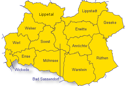
| Locations in the District SOEST (Source: Wikipedia) |
||||||||||||


| The following Ortsregister contains all places of the "Geschichtlichen Orts-Verzeichnisses" (GOV) of CompGen in SOEST. By activating the individual buttons in the four columns >Topo<, >SLUB<, >GOV< and >Meyers<, the geographical location of a place can be called up on a map from the geographical OpenTopoMap and Kartenforum or the place descriptions in the GOV-Ortsverzeichnis and Meyers Gazetteer. | ||||||||||||||||||||||||||
| A | B | C | D | E | F | G | H | I | J | K | L | M | N | O | P | Q | R | S | T | U | V | W | X | Y | Z | |
| Location | Distict | Location Typ | Coordinates | Topo | SLUB | GOV | Meyers | Community affiliation |
| Ahse | Soest | Farming Community | 51.6300 N 008.1300 E |  |
 |
 |
 |
Lippetal |
| Aldehold | Soest | District | 51.6000 N 008.0500 E | |
|
|
|
Welver |
| Allagen | Soest | District | 51.4700 N 008.2300 E | |
|
|
|
Warstein |
| Allen | Soest | District | 51.6200 N 007.8700 E | |
|
|
|
Hamm |
| Alpe | Soest | District | 51.6300 N 008.2300 E | |
|
|
|
Lippstadt |
| Alten Warstein | Soest | District | 51.4200 N 008.3300 E | |
|
|
|
Warstein |
| Altengeseke | Soest | District | 51.5500 N 008.2300 E | |
|
|
|
Anr�chte |
| Altenmellrich | Soest | District | 51.5300 N 008.2700 E | |
|
|
|
Anr�chte |
| Altenr�then | Soest | District | 51.4967 N 008.4065 E | |
|
|
|
R�then |
| Am Ardey | Soest | District | 51.5700 N 008.0700 E | |
|
|
|
Soest |
| Am Brandenbaumerbach | Soest | District | 51.6800 N 008.4700 E | |
|
|
|
Lippstadt |
| Am D�rmen | Soest | District | 51.5800 N 008.0700 E | |
|
|
|
Soest |
| Am Graben | Soest | District | 51.4800 N 007.8500 E | |
|
|
|
Wickede (Ruhr) |
| Am Hegt | Soest | District | 51.3700 N 007.4000 E | |
|
|
|
Hagen |
| Am Hellweg | Soest | District | 51.6357 N 008.4838 E | |
|
|
|
Geseke |
| Am Hellweg | Soest | Place | 51.5800 N 008.2500 E | |
|
|
|
Anr�chte |
| Am Hinderking | Soest | District | 51.5800 N 008.1000 E | |
|
|
|
Soest |
| Am Holtenknapp | Soest | District | 51.5700 N 008.0700 E | |
|
|
|
Soest |
| Am Wietin | Soest | District | 51.6200 N 008.1200 E | |
|
|
|
Lippetal |
| Ameke | Soest | District | 51.6700 N 007.9800 E | |
|
|
|
Welver |
| Ampen | Soest | District | 51.5500 N 008.0500 E | |
|
|
|
Soest |
| An der Ahe | Soest | Place | 51.5800 N 008.2700 E | |
|
|
|
Anr�chte |
| An der Eselstra�e | Soest | District | 51.5700 N 007.9700 E | |
|
|
|
Werl |
| An der Laake | Soest | District | 51.6300 N 008.4500 E | |
|
|
|
Geseke |
| An der Paradieser Br�cke | Soest | District | 51.5700 N 008.0500 E | |
|
|
|
Soest |
| Anepoth | Soest | District | 51.6500 N 008.0500 E | |
|
|
|
Lippetal |
| Anroth | Soest | District | 51.6000 N 007.9800 E | |
|
|
|
Welver |
| Antepoth | Soest | District | 51.6700 N 007.9800 E | |
|
|
|
Welver |
| Aschental | Soest | District | 51.5200 N 008.5000 E | |
|
|
|
R�then |
| Assen | Soest | Noble Estate | |
|
Lippetal | |||
| Assen | Soest | Farming Community | 51.6800 N 008.0700 E | |
|
|
|
Lippetal |
| Auf der H�he | Soest | District | 51.6000 N 008.5000 E | |
|
|
|
Geseke |
| Auf der Huer | Soest | District | 51.6000 N 008.0300 E | |
|
|
|
Welver |
| Auf der Insel | Soest | District | 51.5500 N 008.2800 E | |
|
|
|
Anr�chte |
| Auf´m Brink | Soest | District | 51.6500 N 008.5500 E | |
|
|
|
Geseke |
| Averbeck | Soest | District | 51.6700 N 008.0500 E | |
|
|
|
Lippetal |
| Location | Distict | Location Typ | Coordinates | Topo | SLUB | GOV | Meyers | Community affiliation |
| Bache | Soest | District | 51.4200 N 008.2500 E | |
|
|
|
Warstein |
| Bad Waldliesborn | Soest | District | 51.7000 N 008.3300 E | |
|
|
|
Lippstadt |
| Bad Westernkotten | Soest | District | 51.6300 N 008.3500 E | |
|
|
|
Erwitte |
| Bahnhof Horn | Soest | Place | 51.6000 N 008.2000 E | |
|
|
|
Sassendorf |
| Balksen | Soest | District | 51.6200 N 008.0700 E | |
|
|
|
Welver |
| Becker | Soest | District | 51.6700 N 008.0200 E | |
|
|
|
Lippetal |
| Beckervordersandfort | Soest | District | 51.7000 N 008.0800 E | |
|
|
|
Lippetal |
| Beckhoff | Soest | District | 51.6800 N 008.3000 E | |
|
|
|
Lippstadt |
| Beckmann | Soest | Place | 51.6300 N 008.2300 E | |
|
|
|
Erwitte |
| Beggerie | Soest | District | 51.6000 N 007.9700 E | |
|
|
|
Welver |
| Behringhof | Soest | District | 51.4700 N 007.8300 E | |
|
|
|
Wickede (Ruhr) |
| Belecke | Soest | District | 51.4700 N 008.3300 E | |
|
|
|
Warstein |
| Belmann | Soest | District | 51.6500 N 008.0700 E | |
|
|
|
Lippetal |
| Benninghausen | Soest | City Subdistrict | 51.6500 N 008.2300 E | |
|
|
|
Lippstadt |
| Benninghauser Heide | Soest | District | 51.6500 N 008.2500 E | |
|
|
|
Lippstadt |
| Berenbrock | Soest | District | 51.6000 N 008.2800 E | |
|
|
|
Erwitte |
| Berendwilm | Soest | Place | 51.6200 N 008.3700 E | |
|
|
|
Erwitte |
| Berge | Soest | District | 51.5700 N 008.3700 E | |
|
|
|
Anr�chte |
| Bergede | Soest | Place | 51.5280 N 008.1670 E | |
|
|
|
M�hnesee |
| Bergeder Warte | Soest | District | 51.5300 N 008.1500 E | |
|
|
|
Soest |
| Berghoff | Soest | District | 51.4700 N 008.2500 E | |
|
|
|
Warstein |
| Berkenbusch | Soest | Place | 51.6200 N 008.2800 E | |
|
|
|
Erwitte |
| Berkenhof | Soest | Place | 51.5216 N 008.1767 E | |
|
|
|
M�hnesee |
| Berkhoff | Soest | District | 51.6700 N 007.9800 E | |
|
|
|
Welver |
| Berksen | Soest | District | 51.6300 N 008.0000 E | |
|
|
|
Welver |
| Berlinghoff | Soest | District | 51.6700 N 008.0200 E | |
|
|
|
Lippetal |
| Berlingsen | Soest | Place | 51.5145 N 008.1370 E | |
|
|
|
M�hnesee |
| Berwicke | Soest | District | 51.6200 N 008.0300 E | |
|
|
|
Welver |
| Bettinghausen | Soest | District | 51.6000 N 008.1800 E | |
|
|
|
Sassendorf |
| Beuse | Soest | District | 51.6700 N 008.0200 E | |
|
|
|
Lippetal |
| Beusinger M�hle | Soest | District | 51.5500 N 008.1800 E | |
|
|
|
Sassendorf |
| Beusingsen | Soest | District | 51.5464 N 008.1773 E | |
|
|
|
Sassendorf |
| Bibertal | Soest | District | 51.4700 N 008.4500 E | |
|
|
|
R�then |
| Bielefeld | Soest | Farmstead | 51.6657 N 008.0095 E | |
|
|
|
Welver |
| Bilme | Soest | District | 51.5000 N 008.0000 E | |
|
|
|
Ense |
| Bilmer Grund | Soest | District | 51.5200 N 008.0200 E | |
|
|
|
Ense |
| Bilmergrund | Soest | Place | 51.5241 N 008.0248 E | |
|
|
|
Ense |
| Bilsteinh�hle | Soest | District | 51.4200 N 008.3200 E | |
|
|
|
Warstein |
| Bispinghof | Soest | District | 51.5800 N 007.9200 E | |
|
|
|
Welver |
| Bittingen | Soest | District | 51.5000 N 008.0000 E | |
|
|
|
Ense |
| Blumenthal | Soest | District | 51.5200 N 007.9200 E | |
|
|
|
Ense |
| Blumenthaler Haar | Soest | District | 51.5200 N 007.9200 E | |
|
|
|
Ense |
| Blumenthaler-Haar | Soest | Place | |
|
Ense | |||
| Blumroth | Soest | District | 51.6000 N 008.0700 E | |
|
|
|
Welver |
| B�bbinghof | Soest | District | 51.6700 N 008.2800 E | |
|
|
|
Lippstadt |
| Bockey | Soest | Farmstead | 51.7120 N 007.9903 E | |
|
|
|
Lippetal |
| B�ckum | Soest | District | 51.6300 N 008.2500 E | |
|
|
|
Erwitte |
| Bodmeder Wiesen | Soest | District | 51.4300 N 008.3200 E | |
|
|
|
Warstein |
| Bohnenburg | Soest | Village | 51.4700 N 008.3700 E | |
|
|
|
Warstein |
| Bohnenkamp | Soest | District | 51.5200 N 007.8500 E | |
|
|
|
Wickede (Ruhr) |
| B�kenf�rde | Soest | District | 51.6300 N 008.3800 E | |
|
|
|
Lippstadt |
| B�kenf�rde | Soest | Residential Area | 51.6300 N 008.3800 E | |
|
|
|
Lippstadt |
| B�kenf�rder Warte | Soest | District | 51.6300 N 008.3700 E | |
|
|
|
Lippstadt |
| Boltenhof | Soest | District | 51.5200 N 008.2700 E | |
|
|
|
Anr�chte |
| Bonnekoh | Soest | District | 51.5800 N 007.9700 E | |
|
|
|
Welver |
| B�nninghausen | Soest | District | 51.6500 N 008.4700 E | |
|
|
|
Geseke |
| B�nningh�user M�hle | Soest | District | 51.6700 N 008.4800 E | |
|
|
|
Geseke |
| Borgeler Linde | Soest | District | 51.6000 N 008.0500 E | |
|
|
|
Welver |
| Borgeler M�hle | Soest | District | 51.6000 N 008.0200 E | |
|
|
|
Welver |
| Borgeln | Soest | District | 51.5800 N 008.0300 E | |
|
|
|
Welver |
| Borghausen | Soest | District | 51.6200 N 008.0300 E | |
|
|
|
Welver |
| Brakelmann | Soest | District | 51.6000 N 007.9200 E | |
|
|
|
Welver |
| Brand | Soest | District | 51.6800 N 008.3200 E | |
|
|
|
Lippstadt |
| Brandenbaumer M�hle | Soest | District | 51.6800 N 008.4700 E | |
|
|
|
Lippstadt |
| Bremen | Soest | District | 51.5000 N 007.9500 E | |
|
|
|
Ense |
| Bremerheide | Soest | District | 51.5000 N 007.9300 E | |
|
|
|
Ense |
| Brentrup | Soest | District | 51.6800 N 008.0300 E | |
|
|
|
Lippetal |
| Brinker | Soest | District | 51.6700 N 008.0000 E | |
|
|
|
Lippetal |
| Brinkmann | Soest | District | 51.6000 N 008.0300 E | |
|
|
|
Welver |
| Br�ckelmann | Soest | District | 51.6700 N 008.1700 E | |
|
|
|
Lippetal |
| Brockhausen | Soest | District | 51.6300 N 008.1200 E | |
|
|
|
Lippetal |
| Brockhof | Soest | Place | 51.6300 N 008.2800 E | |
|
|
|
Erwitte |
| Brockmeier | Soest | Place | 51.6200 N 008.3300 E | |
|
|
|
Erwitte |
| Br�mse | Soest | District | 51.7000 N 008.1700 E | |
|
|
|
Lippetal |
| Br�nicke | Soest | Farming Community | 51.6500 N 008.0700 E | |
|
|
|
Lippetal |
| Bruch | Soest | District | 51.5800 N 007.8800 E | |
|
|
|
Werl |
| Bruchgraben | Soest | District | 51.6800 N 008.3200 E | |
|
|
|
Lippstadt |
| Br�derhofe | Soest | District | 51.5800 N 008.0700 E | |
|
|
|
Soest |
| Br�ggenfeld | Soest | District | 51.6800 N 008.0500 E | |
|
|
|
Lippetal |
| Br�llingsen | Soest | Place | 51.5187 N 008.2232 E | |
|
|
|
M�hnesee |
| Brune | Soest | Farmstead | 51.7109 N 007.9952 E | |
|
|
|
Lippetal |
| Br�ningsen | Soest | Place | 51.4897 N 008.0449 E | |
|
|
|
M�hnesee |
| Br�nningsen | Soest | District | 51.5635 N 007.8434 E | |
|
|
|
Werl |
| B�cker | Soest | District | 51.6700 N 008.1800 E | |
|
|
|
Lippetal |
| Budberg | Soest | District | 51.5700 N 007.8700 E | |
|
|
|
Werl |
| Buddem�hle | Soest | District | 51.5800 N 008.0300 E | |
|
|
|
Welver |
| B�derich | Soest | District | 51.5463 N 007.8764 E | |
|
|
|
Werl |
| B�dericher Haar | Soest | District | 51.5200 N 007.8500 E | |
|
|
|
Wickede (Ruhr) |
| B�ecke | Soest | Place | 51.5175 N 008.1073 E | |
|
|
|
M�hnesee |
| B�ninghausen | Soest | Farming Community | 51.6500 N 008.0200 E | |
|
|
|
Lippetal |
| Buschhoff | Soest | District | 51.6800 N 008.0200 E | |
|
|
|
Lippetal |
| Bu�mann | Soest | Farmstead | 51.6800 N 007.9700 E | |
|
|
|
Lippetal |
| Bu�mann | Soest | District | 51.6700 N 007.9800 E | |
|
|
|
Welver |
| B�tfering | Soest | Farmstead | 51.7136 N 007.9899 E | |
|
|
|
Lippetal |
| Butterbrodt | Soest | District | 51.7200 N 007.8300 E | |
|
|
|
Hamm |
| Butterschlot | Soest | District | 51.6700 N 008.1500 E | |
|
|
|
Lippetal |
| Location | Distict | Location Typ | Coordinates | Topo | SLUB | GOV | Meyers | Community affiliation |
| Cappel | Soest | District | 51.6842 N 008.3039 E | |
|
|
|
Lippstadt |
| Location | Distict | Location Typ | Coordinates | Topo | SLUB | GOV | Meyers | Community affiliation |
| Dahlhoff | Soest | District | 51.5000 N 007.9800 E | |
|
|
|
Ense |
| Dahlhofs Hof | Soest | District | 51.5800 N 007.8300 E | |
|
|
|
Hamm |
| Dedinghausen | Soest | District | 51.6690 N 008.4060 E | |
|
|
|
Lippstadt |
| Dedinghauser Heide | Soest | District | 51.6700 N 008.4000 E | |
|
|
|
Lippstadt |
| Deiringsen | Soest | District | 51.5300 N 008.0800 E | |
|
|
|
Soest |
| Delecke | Soest | Place | 51.4866 N 008.0831 E | |
|
|
|
M�hnesee |
| Delecke | Soest | District | 51.4902 N 008.0913 E | |
|
|
|
M�hnesee |
| Dinker | Soest | District | 51.6300 N 007.9500 E | |
|
|
|
Welver |
| Disselhoff | Soest | District | 51.6200 N 007.9700 E | |
|
|
|
Welver |
| Domhof | Soest | Place | 51.5800 N 008.3800 E | |
|
|
|
Anr�chte |
| D�rendahl | Soest | District | 51.6200 N 008.0300 E | |
|
|
|
Welver |
| Dorfwelver | Soest | District | 51.6200 N 007.9500 E | |
|
|
|
Welver |
| D�ringhoff | Soest | District | 51.5000 N 007.9800 E | |
|
|
|
Ense |
| Dreinhoff | Soest | District | 51.7000 N 008.0700 E | |
|
|
|
Lippetal |
| Drewer | Soest | District | 51.5000 N 008.3700 E | |
|
|
|
R�then |
| Dreyer | Soest | District | 51.5800 N 007.9700 E | |
|
|
|
Welver |
| Droste | Soest | District | 51.7000 N 007.9500 E | |
|
|
|
Lippetal |
| Dr�ggelter H�fe | Soest | Place | 51.4916 N 008.0977 E | |
|
|
|
M�hnesee |
| D�llo-Lehmke | Soest | District | 51.7000 N 008.1700 E | |
|
|
|
Wadersloh |
| D�nninghaus | Soest | District | 51.6700 N 008.1700 E | |
|
|
|
Lippetal |
| Location | Distict | Location Typ | Coordinates | Topo | SLUB | GOV | Meyers | Community affiliation |
| Ebbecke | Soest | Farming Community | 51.6800 N 008.0000 E | |
|
|
|
Lippetal |
| Ebbinghaus | Soest | District | 51.6700 N 008.1200 E | |
|
|
|
Lippetal |
| Ebbinghausen | Soest | District | 51.6200 N 008.2700 E | |
|
|
|
Erwitte |
| Echelnp�ten | Soest | District | 51.5000 N 008.2500 E | |
|
|
|
Warstein |
| Echthausen | Soest | District | 51.4800 N 007.8800 E | |
|
|
|
Wickede (Ruhr) |
| Echtrop | Soest | Place | 51.5089 N 008.1810 E | |
|
|
|
M�hnesee |
| Effeln | Soest | District | 51.5200 N 008.3500 E | |
|
|
|
Anr�chte |
| Ehningsen | Soest | District | 51.5700 N 007.9700 E | |
|
|
|
Welver |
| Ehringhausen | Soest | District | 51.6500 N 008.4300 E | |
|
|
|
Geseke |
| Ehringhauser Heide | Soest | District | 51.6500 N 008.4300 E | |
|
|
|
Geseke |
| Eickhoff | Soest | District | 51.4831 N 008.2202 E | |
|
|
|
Warstein |
| Eikeloh | Soest | District | 51.6200 N 008.3800 E | |
|
|
|
Erwitte |
| Eilmsen | Soest | District | 51.6700 N 007.9500 E | |
|
|
|
Welver |
| Einecke | Soest | District | 51.5800 N 007.9800 E | |
|
|
|
Welver |
| Einecker V�hde | Soest | District | 51.6000 N 008.0000 E | |
|
|
|
Welver |
| Eineckerholsen | Soest | District | 51.5800 N 008.0000 E | |
|
|
|
Welver |
| Elfsen | Soest | District | 51.5478 N 008.1540 E | |
|
|
|
Sassendorf |
| Ellies | Soest | District | 51.6700 N 008.0500 E | |
|
|
|
Lippetal |
| Ellingsen | Soest | District | 51.6000 N 008.0800 E | |
|
|
|
Soest |
| Ellingsen | Soest | Place | 51.5173 N 008.2022 E | |
|
|
|
M�hnesee |
| Elsinger Warte | Soest | District | 51.6200 N 008.5200 E | |
|
|
|
Geseke |
| Enkesen bei Paradiese | Soest | District | 51.5500 N 008.0200 E | |
|
|
|
Soest |
| Enkesen im Klei | Soest | District | 51.5700 N 008.2000 E | |
|
|
|
Sassendorf |
| Ennerkswinkel | Soest | District | 51.6200 N 007.9500 E | |
|
|
|
Welver |
| Epsingsen | Soest | Village | 51.5300 N 008.0300 E | |
|
|
|
Soest |
| Eringerfeld | Soest | District | 51.5700 N 008.4700 E | |
|
|
|
Geseke |
| Erley | Soest | District | 51.6000 N 007.9800 E | |
|
|
|
Welver |
| Ermecke | Soest | District | 51.4200 N 008.2500 E | |
|
|
|
Warstein |
| Erminghausen | Soest | District | 51.6300 N 008.4000 E | |
|
|
|
Erwitte |
| Ermsinghausen | Soest | District | |
|
Geseke | |||
| Erwitter Warte | Soest | District | 51.6300 N 008.3300 E | |
|
|
|
Erwitte |
| Esbeck | Soest | District | 51.6800 N 008.3800 E | |
|
|
|
Lippstadt |
| Esbecker Heide | Soest | District | 51.6700 N 008.3700 E | |
|
|
|
Lippstadt |
| Eselbr�cke | Soest | District | 51.5700 N 008.0500 E | |
|
|
|
Soest |
| Ettingerhof | Soest | District | 51.4800 N 008.4700 E | |
|
|
|
R�then |
| Location | Distict | Location Typ | Coordinates | Topo | SLUB | GOV | Meyers | Community affiliation |
| Fahnen | Soest | District | 51.6000 N 008.0200 E | |
|
|
|
Welver |
| Felshof | Soest | District | 51.6200 N 008.0700 E | |
|
|
|
Welver |
| Feuerborn | Soest | District | 51.6700 N 008.0000 E | |
|
|
|
Welver |
| Finken | Soest | Place | 51.6300 N 008.2800 E | |
|
|
|
Erwitte |
| Fleitert | Soest | Place | |
|
Geseke | |||
| Flerke | Soest | District | 51.5800 N 007.9500 E | |
|
|
|
Welver |
| Flerker | Soest | District | 51.5700 N 007.9700 E | |
|
|
|
Welver |
| Fley | Soest | District | 51.3800 N 007.4800 E | |
|
|
|
Hagen |
| Fley | Soest | District | 51.3800 N 007.5000 E | |
|
|
|
Hagen |
| Fleyerviertel | Soest | Place | |
|
Hagen | |||
| Franke | Soest | District | 51.6000 N 008.0200 E | |
|
|
|
Welver |
| Frankenberg | Soest | District | 51.4500 N 008.4200 E | |
|
|
|
R�then |
| Fr�nkenkamp | Soest | District | 51.6000 N 007.9700 E | |
|
|
|
Welver |
| Frerighof | Soest | District | 51.6500 N 008.1500 E | |
|
|
|
Lippetal |
| Fr�hlich | Soest | Farming Community | 51.6800 N 008.0500 E | |
|
|
|
Lippetal |
| F�chtener Heide | Soest | District | 51.4700 N 007.9300 E | |
|
|
|
Ense |
| Location | Distict | Location Typ | Coordinates | Topo | SLUB | GOV | Meyers | Community affiliation |
| Gabrechten | Soest | District | 51.6000 N 008.1700 E | |
|
|
|
Sassendorf |
| Galen | Soest | District | 51.6200 N 007.9500 E | |
|
|
|
Welver |
| Garfeln | Soest | District | 51.6800 N 008.4500 E | |
|
|
|
Lippstadt |
| Gassmann | Soest | District | 51.7000 N 008.1700 E | |
|
|
|
Wadersloh |
| Gerlingen | Soest | District | 51.5300 N 007.9700 E | |
|
|
|
Ense |
| Gerlinger Grund | Soest | District | 51.5200 N 007.9700 E | |
|
|
|
Ense |
| Gertimholte | Soest | Farmstead | 51.7045 N 007.9867 E | |
|
|
|
Lippetal |
| Gert�nis | Soest | District | 51.6700 N 007.9800 E | |
|
|
|
Welver |
| Gerwins Hof | Soest | District | 51.6200 N 007.9200 E | |
|
|
|
Welver |
| Glasmerhof | Soest | Place | 51.6000 N 008.3000 E | |
|
|
|
Erwitte |
| G�bel | Soest | Farmstead | 51.7072 N 007.9972 E | |
|
|
|
Lippetal |
| Goerheide | Soest | District | 51.6700 N 007.9800 E | |
|
|
|
Welver |
| Gottlob | Soest | District | 51.6700 N 008.1000 E | |
|
|
|
Lippetal |
| Gretenallee | Soest | District | 51.6000 N 008.0200 E | |
|
|
|
Welver |
| Griese | Soest | District | 51.5200 N 008.2200 E | |
|
|
|
M�hnesee |
| Gro� Hundorp | Soest | District | 51.6300 N 008.0800 E | |
|
|
|
Welver |
| Gro�e Kersting | Soest | District | 51.7000 N 008.0700 E | |
|
|
|
Lippetal |
| Gro�e Sudhof | Soest | District | 51.5800 N 007.8300 E | |
|
|
|
Hamm |
| Grote | Soest | District | 51.7000 N 008.1800 E | |
|
|
|
Wadersloh |
| Gr�nenbaum | Soest | Residential Area | 51.5050 N 007.8324 E | |
|
|
|
Wickede (Ruhr) |
| G�nne | Soest | Place | 51.4985 N 008.0497 E | |
|
|
|
M�hnesee |
| Gut M�lheim | Soest | District | 51.4955 N 008.2746 E | |
|
|
|
Warstein |
| Location | Distict | Location Typ | Coordinates | Topo | SLUB | GOV | Meyers | Community affiliation |
| Haar | Soest | District | 51.4983 N 007.9902 E | |
|
|
|
Ense |
| Haarh�fe | Soest | District | 51.5000 N 008.2200 E | |
|
|
|
Warstein |
| Hachenei | Soest | District | 51.6200 N 008.0200 E | |
|
|
|
Welver |
| Hackeloh | Soest | Place | 51.5319 N 008.1896 E | |
|
|
|
M�hnesee |
| Hagedorn | Soest | District | 51.6700 N 008.1700 E | |
|
|
|
Lippetal |
| Hagenh�fe | Soest | District | 51.6300 N 008.1300 E | |
|
|
|
Lippetal |
| Hagenhoff | Soest | District | 51.6800 N 008.0300 E | |
|
|
|
Lippetal |
| Hagenkamp | Soest | District | 51.6300 N 008.1300 E | |
|
|
|
Lippetal |
| Hagenschulte | Soest | District | 51.6800 N 008.0500 E | |
|
|
|
Lippetal |
| Hahues | Soest | District | 51.6800 N 008.0000 E | |
|
|
|
Lippetal |
| Hangfort | Soest | District | 51.6700 N 007.9800 E | |
|
|
|
Welver |
| Hanhoff | Soest | District | 51.6700 N 008.1300 E | |
|
|
|
Lippetal |
| Hanschenm�hle | Soest | District | 51.6500 N 008.5000 E | |
|
|
|
Geseke |
| Harbruch | Soest | District | 51.6200 N 007.9700 E | |
|
|
|
Welver |
| Harringholz Siedlung | Soest | District | 51.6300 N 007.7500 E | |
|
|
|
Hamm |
| Hartmann | Soest | District | 51.6700 N 008.0500 E | |
|
|
|
Lippetal |
| Haselhorst | Soest | District | 51.6000 N 008.0300 E | |
|
|
|
Welver |
| Hattrop | Soest | District | 51.5800 N 008.0700 E | |
|
|
|
Soest |
| Hattropholsen | Soest | District | 51.5800 N 008.0500 E | |
|
|
|
Soest |
| Haus Ahse | Soest | District | 51.6300 N 008.1500 E | |
|
|
|
Sassendorf |
| Haus Borg | Soest | District | 51.5700 N 007.8700 E | |
|
|
|
Werl |
| Haus Brockhausen | Soest | Estate | 51.6300 N 008.1200 E | |
|
|
|
Lippetal |
| Haus Broel | Soest | District | 51.5800 N 008.0300 E | |
|
|
|
Welver |
| Haus Delecke | Soest | Residential Area | 51.4892 N 008.0722 E | |
|
|
|
M�hnesee |
| Haus D�sse | Soest | District | 51.6300 N 008.1700 E | |
|
|
|
Sassendorf |
| Haus F�chten | Soest | District | 51.4800 N 007.9200 E | |
|
|
|
Ense |
| Haus L�mmerbach | Soest | District | 51.6500 N 008.4200 E | |
|
|
|
Geseke |
| Haus Meyerich | Soest | District | 51.6000 N 007.9500 E | |
|
|
|
Welver |
| Haus Middelburg | Soest | Estate | 51.6500 N 008.1200 E | |
|
|
|
Lippetal |
| Haus Nateln | Soest | District | 51.6200 N 008.0000 E | |
|
|
|
Welver |
| Haus Nehlen | Soest | District | 51.6200 N 008.0200 E | |
|
|
|
Welver |
| Haus S�bberinghof | Soest | Place | 51.5800 N 008.3200 E | |
|
|
|
Anr�chte |
| Haus Teipla� | Soest | District | 51.4800 N 008.2700 E | |
|
|
|
Warstein |
| Heckentrup | Soest | Farming Community | 51.6800 N 008.1200 E | |
|
|
|
Lippetal |
| Heddinghausen | Soest | District | 51.5500 N 008.4700 E | |
|
|
|
R�then |
| Hegemann | Soest | District | 51.6700 N 008.0300 E | |
|
|
|
Lippetal |
| Hegener | Soest | District | 51.5800 N 007.8800 E | |
|
|
|
Werl |
| Heidberg | Soest | District | 51.4500 N 008.5200 E | |
|
|
|
R�then |
| Heide | Soest | District | 51.6300 N 008.2200 E | |
|
|
|
Lippstadt |
| Heidebauer | Soest | District | 51.5700 N 007.9500 E | |
|
|
|
Werl |
| Heider�schen | Soest | District | 51.5200 N 007.9300 E | |
|
|
|
Ense |
| Heidhues | Soest | District | 51.6700 N 008.0200 E | |
|
|
|
Lippetal |
| Heimann | Soest | District | 51.6500 N 008.2000 E | |
|
|
|
Wadersloh |
| Heintrop | Soest | Village | 51.6500 N 008.0300 E | |
|
|
|
Lippetal |
| Heintrop-B�ninghausen | Soest | District | 51.6500 N 008.0300 E | |
|
|
|
Lippetal |
| Hellinghausen | Soest | District | 51.6500 N 008.2800 E | |
|
|
|
Lippstadt |
| Hellweg | Soest | District | 51.5300 N 007.8500 E | |
|
|
|
Wickede (Ruhr) |
| Hellweg | Soest | District | 51.5500 N 008.0300 E | |
|
|
|
Soest |
| Helmig | Soest | District | 51.6700 N 008.1700 E | |
|
|
|
Lippetal |
| Hemmergrund | Soest | District | 51.5300 N 008.4800 E | |
|
|
|
R�then |
| Hemmern | Soest | District | 51.5200 N 008.4500 E | |
|
|
|
R�then |
| Hemmis | Soest | District | 51.6000 N 008.1000 E | |
|
|
|
Soest |
| Hemmis | Soest | District | 51.6700 N 008.1200 E | |
|
|
|
Lippetal |
| Henkemeier | Soest | District | 51.6800 N 008.3800 E | |
|
|
|
Lippstadt |
| Hense-Sengeling | Soest | Place | 51.6200 N 008.2800 E | |
|
|
|
Erwitte |
| Heppen | Soest | District | 51.5800 N 008.1500 E | |
|
|
|
Soest |
| Herringhausen | Soest | District | 51.6500 N 008.2800 E | |
|
|
|
Lippstadt |
| Herringsen | Soest | District | 51.5300 N 008.2300 E | |
|
|
|
Sassendorf |
| Herringser H�fe | Soest | District | 51.5377 N 008.2161 E | |
|
|
|
Sassendorf |
| Herrlichkeit | Soest | District | 51.4200 N 008.3300 E | |
|
|
|
Warstein |
| Herzfeld | Soest | District | 51.6500 N 008.1500 E | |
|
|
|
Lippetal |
| Herzfeld | Soest | District | |
|
Lippetal | |||
| Hesselgrund | Soest | District | 51.5000 N 008.3200 E | |
|
|
|
Warstein |
| Hessing | Soest | District | 51.7000 N 008.0700 E | |
|
|
|
Lippetal |
| Hewingsen | Soest | Place | 51.5200 N 008.0437 E | |
|
|
|
M�hnesee |
| Hiddingsen | Soest | District | 51.5300 N 008.1000 E | |
|
|
|
Soest |
| Hilbeck | Soest | District | 51.5800 N 007.8500 E | |
|
|
|
Werl |
| Hilgenberg | Soest | District | 51.6800 N 007.9800 E | |
|
|
|
Lippetal |
| Hilgenkamp | Soest | District | 51.6000 N 008.0000 E | |
|
|
|
Welver |
| Hillingsen | Soest | District | 51.6200 N 008.0700 E | |
|
|
|
Welver |
| Hilverding | Soest | District | 51.6300 N 008.1700 E | |
|
|
|
Sassendorf |
| Himmelpforten | Soest | District | 51.4800 N 008.0000 E | |
|
|
|
Ense |
| Hinse | Soest | District | 51.6700 N 008.1700 E | |
|
|
|
Lippetal |
| Hintern Heubreuken | Soest | District | 51.6700 N 008.4800 E | |
|
|
|
Geseke |
| Hirschberg | Soest | District | 51.4200 N 008.2700 E | |
|
|
|
Warstein |
| Hof Flerke | Soest | District | 51.5800 N 007.9300 E | |
|
|
|
Werl |
| Hof zu Osten | Soest | District | 51.6200 N 008.3800 E | |
|
|
|
Lippstadt |
| Hoffmeier | Soest | District | 51.6700 N 008.0000 E | |
|
|
|
Welver |
| H�hberg | Soest | District | 51.5300 N 007.9700 E | |
|
|
|
Ense |
| Hohoff | Soest | District | 51.6700 N 008.0300 E | |
|
|
|
Lippetal |
| H�ingen | Soest | District | 51.4800 N 007.9700 E | |
|
|
|
Ense |
| H�inger Heide | Soest | District | 51.4700 N 007.9700 E | |
|
|
|
Ense |
| Hoinkhausen | Soest | District | 51.5500 N 008.4000 E | |
|
|
|
R�then |
| Holkemann | Soest | District | 51.6700 N 008.1300 E | |
|
|
|
Lippetal |
| H�llinghofen | Soest | District | 51.4700 N 007.8800 E | |
|
|
|
Wickede (Ruhr) |
| H�lterberg | Soest | District | 51.6200 N 008.5500 E | |
|
|
|
Geseke |
| H�lterhof | Soest | District | 51.6200 N 008.5700 E | |
|
|
|
Geseke |
| Holth�fen | Soest | District | 51.6200 N 007.8700 E | |
|
|
|
Hamm |
| Holtkamp | Soest | District | 51.6000 N 008.0000 E | |
|
|
|
Welver |
| Holtum | Soest | District | 51.5500 N 007.8500 E | |
|
|
|
Werl |
| H�ntrup | Soest | Farming Community | 51.6800 N 008.1700 E | |
|
|
|
Lippetal |
| Horn | Soest | Place | 51.6100 N 008.2400 E | |
|
|
|
Erwitte |
| Horn-Millinghausen | Soest | District | |
|
Erwitte | |||
| H�rste | Soest | District | 51.6800 N 008.4300 E | |
|
|
|
Lippstadt |
| H�rster | Soest | District | 51.6700 N 008.0300 E | |
|
|
|
Lippetal |
| Hovestadt | Soest | Village | 51.6570 N 008.1440 E | |
|
|
|
Lippetal |
| Hubbig | Soest | Farmstead | 51.7061 N 007.9883 E | |
|
|
|
Lippetal |
| H�ffer | Soest | District | 51.6500 N 008.0700 E | |
|
|
|
Lippetal |
| Hultrop | Soest | District | 51.6500 N 008.0500 E | |
|
|
|
Lippetal |
| Humbrechting | Soest | District | 51.6300 N 008.1700 E | |
|
|
|
Lippetal |
| Hundebusch | Soest | District | 51.6500 N 008.2800 E | |
|
|
|
Lippstadt |
| H�ndlingsen | Soest | District | 51.6500 N 007.9800 E | |
|
|
|
Welver |
| H�nningen | Soest | District | 51.4800 N 007.9300 E | |
|
|
|
Ense |
| H�sen | Soest | District | 51.6200 N 008.0000 E | |
|
|
|
Welver |
| H�singlo | Soest | District | 51.6300 N 008.0800 E | |
|
|
|
Welver |
| H�steder M�hle | Soest | District | 51.6500 N 008.5000 E | |
|
|
|
Geseke |
| H�stederfeld | Soest | District | 51.6700 N 008.5000 E | |
|
|
|
Geseke |
| H�ttinghausen | Soest | District | 51.6200 N 008.1300 E | |
|
|
|
Lippetal |
| Location | Distict | Location Typ | Coordinates | Topo | SLUB | GOV | Meyers | Community affiliation |
| Illingen | Soest | District | 51.6200 N 007.9200 E | |
|
|
|
Welver |
| Im Brandholz | Soest | Place | 51.5200 N 008.1500 E | |
|
|
|
M�hnesee |
| Im faulen Poth | Soest | District | 51.5700 N 008.1500 E | |
|
|
|
Soest |
| Im Friesenbruch | Soest | District | 51.6800 N 008.3200 E | |
|
|
|
Lippstadt |
| Im H�lzchen | Soest | District | 51.5200 N 008.3000 E | |
|
|
|
Anr�chte |
| Im Kirchholz | Soest | District | 51.5300 N 008.2300 E | |
|
|
|
Sassendorf |
| Im Kleefeld | Soest | Place | 51.5800 N 008.2500 E | |
|
|
|
Anr�chte |
| Im Westholz | Soest | District | 51.5700 N 007.9800 E | |
|
|
|
Welver |
| In den Sch�rren | Soest | Place | 51.2500 N 007.1200 E | |
|
|
|
Wuppertal |
| In der Brumecke | Soest | District | 51.5700 N 008.0700 E | |
|
|
|
Soest |
| In der Mirke | Soest | Place | 51.2700 N 007.1500 E | |
|
|
|
Wuppertal |
| In der Rumbrei | Soest | District | 51.5200 N 008.2800 E | |
|
|
|
Anr�chte |
| Location | Distict | Location Typ | Coordinates | Topo | SLUB | GOV | Meyers | Community affiliation |
| Jagdhaus Hubertus | Soest | District | 51.4200 N 008.4300 E | |
|
|
|
R�then |
| J�nglingshof | Soest | District | 51.6000 N 008.0700 E | |
|
|
|
Welver |
| Location | Distict | Location Typ | Coordinates | Topo | SLUB | GOV | Meyers | Community affiliation |
| Kaldewei | Soest | District | 51.6300 N 008.2700 E | |
|
|
|
Erwitte |
| Kallenhardt | Soest | District | 51.4500 N 008.4200 E | |
|
|
|
R�then |
| Kallenhardter Heide | Soest | District | 51.4300 N 008.4200 E | |
|
|
|
R�then |
| Kaltenhagen | Soest | District | 51.6000 N 007.9200 E | |
|
|
|
Welver |
| Kalthof | Soest | District | 51.6300 N 008.1700 E | |
|
|
|
Sassendorf |
| Kamenhof | Soest | District | 51.5800 N 008.1000 E | |
|
|
|
Soest |
| K�merhof | Soest | Place | |
|
Herzogenrath | |||
| K�merh�f | Soest | Place | 50.8500 N 006.1000 E | |
|
|
|
|
| K�mpchen | Soest | District | 51.5500 N 008.2000 E | |
|
|
|
Sassendorf |
| Kappel | Soest | District | 51.6500 N 008.1800 E | |
|
|
|
Wadersloh |
| Katrop | Soest | District | 51.6000 N 008.0800 E | |
|
|
|
Soest |
| Katroper H�he | Soest | District | 51.5800 N 008.0800 E | |
|
|
|
Soest |
| Kellinghausen | Soest | District | 51.5300 N 008.4300 E | |
|
|
|
R�then |
| Kersting | Soest | District | 51.6800 N 008.0500 E | |
|
|
|
Lippetal |
| Kesseler | Soest | Farming Community | 51.6700 N 008.1000 E | |
|
|
|
Lippetal |
| Ke�ler | Soest | District | 51.6700 N 008.0000 E | |
|
|
|
Lippetal |
| Kettlerholz | Soest | District | 51.6200 N 007.9500 E | |
|
|
|
Welver |
| Kirchfeld | Soest | District | 51.6000 N 007.9500 E | |
|
|
|
Welver |
| Kirchwelver | Soest | District | 51.6200 N 007.9500 E | |
|
|
|
Welver |
| Kleiloh | Soest | District | 51.6500 N 007.9800 E | |
|
|
|
Welver |
| Klein Hundorp | Soest | District | 51.6300 N 008.0800 E | |
|
|
|
Lippetal |
| Klieve | Soest | District | 51.5700 N 008.2800 E | |
|
|
|
Anr�chte |
| Klotingen | Soest | District | 51.6000 N 007.9700 E | |
|
|
|
Welver |
| Klotingerheide | Soest | District | 51.6000 N 007.9700 E | |
|
|
|
Welver |
| Knappe | Soest | District | 51.5000 N 007.8800 E | |
|
|
|
Wickede (Ruhr) |
| Kneblinghausen | Soest | District | 51.5000 N 008.5000 E | |
|
|
|
R�then |
| K�bbinghof | Soest | District | 51.4888 N 008.1957 E | |
|
|
|
M�hnesee |
| Kockerbeck | Soest | District | 51.6700 N 007.9800 E | |
|
|
|
Welver |
| Koenekenhof | Soest | District | 51.5200 N 008.2700 E | |
|
|
|
Anr�chte |
| K�nig | Soest | District | 51.6700 N 008.0200 E | |
|
|
|
Lippetal |
| K�ningerm�hle | Soest | District | 51.5800 N 007.9500 E | |
|
|
|
Welver |
| K�rbecke | Soest | Place | 51.4978 N 008.1301 E | |
|
|
|
M�hnesee |
| Kortenm�hlr | Soest | District | 51.6200 N 007.9300 E | |
|
|
|
Welver |
| K�rtlinghausen | Soest | District | 51.4500 N 008.4000 E | |
|
|
|
R�then |
| Kotten | Soest | District | 51.6000 N 008.0200 E | |
|
|
|
Welver |
| Kranenkasper | Soest | District | 51.6800 N 008.3500 E | |
|
|
|
Lippstadt |
| Kreggenfeld | Soest | District | 51.6000 N 007.9500 E | |
|
|
|
Welver |
| Krewinkel-Wiltrop | Soest | District | |
|
Lippetal | |||
| Kuhholz | Soest | District | 51.6200 N 007.9500 E | |
|
|
|
Welver |
| Kuhlbusch | Soest | District | 51.5000 N 007.8800 E | |
|
|
|
Ense |
| Kummerwie | Soest | District | 51.6000 N 008.1300 E | |
|
|
|
Sassendorf |
| Kump | Soest | District | 51.5800 N 007.8500 E | |
|
|
|
Werl |
| Kutmecke | Soest | Residential Area | 51.6085 N 008.1292 E | |
|
|
|
Th�ningsen |
| Kutmecker H�he | Soest | District | 51.5800 N 008.1200 E | |
|
|
|
Soest |
| Kutmeke | Soest | District | 51.6000 N 008.1200 E | |
|
|
|
Soest |
| Location | Distict | Location Typ | Coordinates | Topo | SLUB | GOV | Meyers | Community affiliation |
| Lammert | Soest | District | 51.6300 N 008.1700 E | |
|
|
|
Sassendorf |
| Lammert | Soest | District | 51.7000 N 008.1700 E | |
|
|
|
Wadersloh |
| Landwehr | Soest | District | 51.5700 N 007.9700 E | |
|
|
|
Welver |
| Langeneicke | Soest | District | 51.6300 N 008.4300 E | |
|
|
|
Geseke |
| Langenh�vel | Soest | District | 51.6800 N 007.9800 E | |
|
|
|
Lippetal |
| Langenstra�e | Soest | District | 51.5500 N 008.4500 E | |
|
|
|
R�then |
| Langenstra�e-Heddinghausen | Soest | District | |
|
R�then | |||
| Laumeier | Soest | District | 51.6700 N 008.1700 E | |
|
|
|
Lippetal |
| Lechterbeck-Eckhardt | Soest | District | 51.5700 N 007.8300 E | |
|
|
|
Werl |
| Lendringsen | Soest | District | 51.5338 N 008.1275 E | |
|
|
|
Soest |
| Lieth | Soest | District | 51.4800 N 008.3000 E | |
|
|
|
Warstein |
| Liethe | Soest | District | 51.6000 N 007.9500 E | |
|
|
|
Welver |
| Lindental | Soest | District | 51.5000 N 008.4000 E | |
|
|
|
R�then |
| Linnemann | Soest | District | 51.6500 N 008.2700 E | |
|
|
|
Wadersloh |
| Lippborg | Soest | District | |
|
Lippetal | |||
| Lippborg | Soest | Village | 51.6700 N 008.0300 E | |
|
|
|
Lippetal |
| Lipperbruch | Soest | District | 51.7000 N 008.3700 E | |
|
|
|
Lippstadt |
| Lipperode | Soest | District | 51.6927 N 008.3763 E | |
|
|
|
Lippstadt |
| Lippling | Soest | District | 51.6500 N 008.0700 E | |
|
|
|
Lippetal |
| Lippst�dter Fichten | Soest | District | 51.6800 N 008.3700 E | |
|
|
|
Lippstadt |
| L�bbeckenhof | Soest | Place | 51.5158 N 008.1742 E | |
|
|
|
M�hnesee |
| Loerbrockshof | Soest | District | 51.6000 N 008.1800 E | |
|
|
|
Sassendorf |
| Loh | Soest | District | 51.6200 N 007.9800 E | |
|
|
|
Welver |
| Lohagen | Soest | District | 51.5700 N 008.2500 E | |
|
|
|
Anr�chte |
| Lohe | Soest | District | 51.6300 N 008.2200 E | |
|
|
|
Lippstadt |
| Lohmeyer | Soest | District | 51.6700 N 008.2000 E | |
|
|
|
Lippetal |
| Lohne | Soest | District | 51.5800 N 008.1800 E | |
|
|
|
Sassendorf |
| Lohneklei | Soest | District | 51.5700 N 008.1800 E | |
|
|
|
Sassendorf |
| Lohner Warte | Soest | Place | 51.5800 N 008.2200 E | |
|
|
|
Sassendorf |
| Lohof | Soest | District | 51.5800 N 008.1500 E | |
|
|
|
Sassendorf |
| L�hringsen | Soest | District | 51.6000 N 008.1000 E | |
|
|
|
Soest |
| Luicke | Soest | District | 51.6700 N 007.9800 E | |
|
|
|
Welver |
| Luisenhof | Soest | District | 51.5500 N 008.0800 E | |
|
|
|
Soest |
| Lunke | Soest | District | 51.6700 N 007.9800 E | |
|
|
|
Welver |
| Lusebrink | Soest | Place | 51.5800 N 008.2700 E | |
|
|
|
Anr�chte |
| Luster | Soest | District | 51.6700 N 008.2000 E | |
|
|
|
Wadersloh |
| L�tge Sudhof | Soest | District | 51.5800 N 007.8300 E | |
|
|
|
Hamm |
| L�tgen Ampen | Soest | District | 51.5500 N 008.0700 E | |
|
|
|
Soest |
| L�tgenbrockhausen | Soest | District | 51.6300 N 008.1200 E | |
|
|
|
Lippetal |
| Luthmann | Soest | District | 51.6700 N 008.0200 E | |
|
|
|
Lippetal |
| L�tke | Soest | District | 51.7000 N 007.9800 E | |
|
|
|
Lippetal |
| L�tke-Uentrup | Soest | Farming Community | |
|
Lippetal | |||
| L�ttringen | Soest | District | 51.4800 N 007.9300 E | |
|
|
|
Ense |
| Location | Distict | Location Typ | Coordinates | Topo | SLUB | GOV | Meyers | Community affiliation |
| Magh | Soest | District | 51.6700 N 008.0500 E | |
|
|
|
Lippetal |
| Mark | Soest | District | 51.6800 N 007.9800 E | |
|
|
|
Lippetal |
| Matena | Soest | District | 51.6200 N 007.9500 E | |
|
|
|
Welver |
| Mawicke | Soest | District | 51.5500 N 007.9700 E | |
|
|
|
Werl |
| Meckingsen | Soest | District | 51.5800 N 008.0700 E | |
|
|
|
Soest |
| Mehrhof | Soest | Residential Area | 51.6132 N 008.1351 E | |
|
|
|
Soest |
| Meiningsen | Soest | Church Village | 51.5300 N 008.0500 E | |
|
|
|
Soest |
| Meiningserbauer | Soest | District | 51.5247 N 008.0644 E | |
|
|
|
M�hnesee |
| Meiste | Soest | District | 51.5000 N 008.4800 E | |
|
|
|
R�then |
| Mellrich | Soest | District | 51.5300 N 008.2800 E | |
|
|
|
Anr�chte |
| Mense | Soest | District | 51.6800 N 008.2800 E | |
|
|
|
Wadersloh |
| Mentzelsfelde | Soest | District | 51.7000 N 008.3500 E | |
|
|
|
Lippstadt |
| Menzel | Soest | District | 51.5200 N 008.4000 E | |
|
|
|
R�then |
| Merklinghausen | Soest | Hamlet | 51.6000 N 008.2200 E | |
|
|
|
Erwitte |
| Merklinghausen-Wiggeringhausen | Soest | District | |
|
Erwitte | |||
| Merklingsen | Soest | District | 51.5700 N 007.9800 E | |
|
|
|
Welver |
| Mersch | Soest | District | 51.6800 N 008.3800 E | |
|
|
|
Lippstadt |
| Mester | Soest | District | 51.6500 N 008.0700 E | |
|
|
|
Lippetal |
| Mettinghausen | Soest | District | 51.7000 N 008.4300 E | |
|
|
|
Lippstadt |
| Meyer | Soest | District | 51.7000 N 008.0800 E | |
|
|
|
Lippetal |
| Meyerich | Soest | District | 51.6000 N 007.9500 E | |
|
|
|
Welver |
| Michelnhof | Soest | Place | 51.5200 N 008.1700 E | |
|
|
|
M�hnesee |
| Middeler | Soest | District | 51.5800 N 007.8800 E | |
|
|
|
Werl |
| Mildental | Soest | District | 51.5000 N 008.4200 E | |
|
|
|
R�then |
| Millinghausen | Soest | Village | 51.6200 N 008.2500 E | |
|
|
|
Erwitte |
| Mittelhausen | Soest | District | 51.6200 N 008.4200 E | |
|
|
|
Geseke |
| M�hnetal | Soest | District | 51.4700 N 008.4300 E | |
|
|
|
R�then |
| M�llenhoff | Soest | District | 51.6700 N 008.1300 E | |
|
|
|
Lippetal |
| M�nninghausen | Soest | District | 51.6700 N 008.4500 E | |
|
|
|
Geseke |
| M�hlenfeld | Soest | District | 51.6200 N 007.9300 E | |
|
|
|
Welver |
| M�lheim | Soest | District | 51.4800 N 008.2800 E | |
|
|
|
Warstein |
| M�llingsen | Soest | District | 51.5300 N 008.1300 E | |
|
|
|
Soest |
| Mund | Soest | District | 51.6800 N 008.0500 E | |
|
|
|
Lippetal |
| Musshoff | Soest | District | 51.6700 N 008.1700 E | |
|
|
|
Lippetal |
| Location | Distict | Location Typ | Coordinates | Topo | SLUB | GOV | Meyers | Community affiliation |
| Nachtigall | Soest | District | 51.4700 N 007.8500 E | |
|
|
|
Wickede (Ruhr) |
| Nahmer | Soest | District | 51.3200 N 007.5700 E | |
|
|
|
Hagen |
| Nahtfeld | Soest | District | 51.6500 N 008.3000 E | |
|
|
|
Lippstadt |
| Naschert | Soest | District | 51.6700 N 008.1200 E | |
|
|
|
Lippetal |
| Nateln | Soest | District | 51.6200 N 008.0000 E | |
|
|
|
Welver |
| Nehlerheide | Soest | District | 51.6000 N 008.0000 E | |
|
|
|
Welver |
| Nettelst�dt | Soest | District | 51.5300 N 008.3800 E | |
|
|
|
R�then |
| Nettelst�dt | Soest | District | 51.5300 N 008.3800 E | |
|
|
|
Anr�chte |
| Neue M�hle | Soest | District | 51.5700 N 008.0700 E | |
|
|
|
Soest |
| Neuengeseke | Soest | District | 51.5500 N 008.1800 E | |
|
|
|
Sassendorf |
| Neuengeseker Heide | Soest | District | 51.5425 N 008.2003 E | |
|
|
|
Sassendorf |
| Neuengeseker Warte | Soest | District | 51.5500 N 008.2200 E | |
|
|
|
Sassendorf |
| Neuengeseker-Heide | Soest | Place | 51.5430 N 008.2000 E | |
|
|
|
Sassendorf |
| Neuenkamp | Soest | District | 51.6300 N 008.1800 E | |
|
|
|
Sassendorf |
| Niederbauer | Soest | District | 51.6500 N 008.1000 E | |
|
|
|
Lippetal |
| Niederbergheim | Soest | City Subdistrict | 51.4700 N 008.2200 E | |
|
|
|
Warstein |
| Niederbergstra�e | Soest | District | 51.5700 N 007.9700 E | |
|
|
|
Werl |
| Niederdedinghausen | Soest | District | 51.7000 N 008.4000 E | |
|
|
|
Lippstadt |
| Niederense | Soest | District | 51.4800 N 007.9800 E | |
|
|
|
Ense |
| Niederm�ller | Soest | District | 51.6000 N 007.9200 E | |
|
|
|
Welver |
| N�lke | Soest | District | 51.6800 N 008.3000 E | |
|
|
|
Lippstadt |
| Nomekenhof | Soest | District | 51.6700 N 008.2700 E | |
|
|
|
Wadersloh |
| Nordalm | Soest | District | 51.6000 N 007.8700 E | |
|
|
|
Hamm |
| Norddorf | Soest | District | 51.6300 N 008.2700 E | |
|
|
|
Erwitte |
| Nordhaus | Soest | District | 51.7000 N 008.1700 E | |
|
|
|
Lippetal |
| Nordhues | Soest | District | 51.6800 N 008.0200 E | |
|
|
|
Lippetal |
| Nordwald | Soest | District | 51.6500 N 008.1300 E | |
|
|
|
Lippetal |
| N�ttenhofe | Soest | District | 51.5700 N 008.0700 E | |
|
|
|
Soest |
| N�tting | Soest | District | 51.6000 N 007.9700 E | |
|
|
|
Welver |
| Location | Distict | Location Typ | Coordinates | Topo | SLUB | GOV | Meyers | Community affiliation |
| Oberbergheim | Soest | District | 51.4800 N 008.2200 E | |
|
|
|
Warstein |
| Oberbergstra�e | Soest | District | 51.5500 N 007.9700 E | |
|
|
|
Werl |
| Oberense | Soest | District | 51.5000 N 007.9800 E | |
|
|
|
Ense |
| Oberkellners Br�che | Soest | Place | 51.4300 N 008.1800 E | |
|
|
|
M�hnesee |
| Ochsenholzh�fe | Soest | District | 51.6000 N 008.5300 E | |
|
|
|
Geseke |
| Oechtringhausen | Soest | District | 51.6700 N 008.4200 E | |
|
|
|
Lippstadt |
| Oelm�hle | Soest | District | 51.6500 N 008.5000 E | |
|
|
|
Geseke |
| Oestereiden | Soest | District | 51.5500 N 008.4200 E | |
|
|
|
R�then |
| Oesterheide | Soest | Farming Community | 51.6500 N 008.0700 E | |
|
|
|
Lippetal |
| Oesterndorf | Soest | District | 51.6500 N 008.1000 E | |
|
|
|
Lippetal |
| Oestinghausen | Soest | District | 51.6300 N 008.0800 E | |
|
|
|
Lippetal |
| Oevinghausen | Soest | Estate | 51.5067 N 007.8974 E | |
|
|
|
Ense |
| Opm�nden | Soest | District | 51.5500 N 008.1700 E | |
|
|
|
Sassendorf |
| Osker | Soest | Farming Community | 51.6885 N 007.9889 E | |
|
|
|
Lippetal |
| Oskerheide | Soest | District | 51.6800 N 007.9800 E | |
|
|
|
Lippetal |
| Ostb�derich | Soest | District | 51.5400 N 007.8700 E | |
|
|
|
Werl |
| Ostbusch | Soest | District | 51.6000 N 007.9700 E | |
|
|
|
Welver |
| Osterflierich | Soest | District | 51.5800 N 007.8300 E | |
|
|
|
Hamm |
| Ostermann | Soest | District | 51.6800 N 008.0500 E | |
|
|
|
Lippetal |
| Ostermanns Hof | Soest | District | 51.6200 N 007.9200 E | |
|
|
|
Welver |
| Ostheide | Soest | District | 51.5200 N 008.2300 E | |
|
|
|
Anr�chte |
| Osthof | Soest | District | 51.6200 N 008.0000 E | |
|
|
|
Welver |
| Osthofe | Soest | District | 51.5700 N 008.1200 E | |
|
|
|
Soest |
| Osthoff | Soest | District | 51.6300 N 007.9000 E | |
|
|
|
Hamm |
| Ostinghausen | Soest | District | 51.6300 N 008.1800 E | |
|
|
|
Sassendorf |
| Ost�nnen | Soest | Church Village | 51.5500 N 008.0000 E | |
|
|
|
Soest |
| Ost�nnerlinde | Soest | District | 51.5500 N 008.0000 E | |
|
|
|
Soest |
| Overhagen | Soest | District | 51.6500 N 008.3000 E | |
|
|
|
Lippstadt |
| Location | Distict | Location Typ | Coordinates | Topo | SLUB | GOV | Meyers | Community affiliation |
| Palmberg | Soest | District | 51.5800 N 008.0500 E | |
|
|
|
Soest |
| Paradiese | Soest | District | 51.5700 N 008.0500 E | |
|
|
|
Soest |
| Parsit | Soest | District | 51.4800 N 007.9500 E | |
|
|
|
Ense |
| Pastorat | Soest | District | 51.6700 N 008.2800 E | |
|
|
|
Lippstadt |
| Pedinghausen | Soest | District | 51.5800 N 007.8300 E | |
|
|
|
Werl |
| Pentling | Soest | District | 51.5800 N 007.8500 E | |
|
|
|
Werl |
| Pferdekamp | Soest | District | 51.6000 N 007.9700 E | |
|
|
|
Welver |
| Pieper | Soest | District | 51.6800 N 007.9700 E | |
|
|
|
Lippetal |
| Plan M�hle | Soest | District | 51.5800 N 008.0300 E | |
|
|
|
Welver |
| Plange | Soest | District | 51.6200 N 008.0800 E | |
|
|
|
Soest |
| Pla�mann | Soest | District | 51.6700 N 008.1700 E | |
|
|
|
Lippetal |
| Plattenberg | Soest | District | 51.6800 N 007.9800 E | |
|
|
|
Lippetal |
| Pockes Ecke | Soest | Farming Community | 51.6500 N 008.0800 E | |
|
|
|
Lippetal |
| Pohlmann | Soest | District | 51.6700 N 008.0200 E | |
|
|
|
Lippetal |
| Polmer | Soest | Farming Community | 51.6700 N 008.0200 E | |
|
|
|
Lippetal |
| P�psel | Soest | District | 51.6700 N 008.1700 E | |
|
|
|
Lippetal |
| P�psel-Nienkerken | Soest | District | 51.6700 N 008.1200 E | |
|
|
|
Lippetal |
| P�psel-Schl�ppner | Soest | District | 51.6700 N 008.1200 E | |
|
|
|
Lippetal |
| Prinz | Soest | District | 51.5300 N 008.3200 E | |
|
|
|
Anr�chte |
| Pr�bsting | Soest | District | 51.5800 N 007.8700 E | |
|
|
|
Werl |
| Location | Distict | Location Typ | Coordinates | Topo | SLUB | GOV | Meyers | Community affiliation |
| Quabbem�hle | Soest | District | 51.6700 N 008.0500 E | |
|
|
|
Lippetal |
| Qualenbrink | Soest | District | 51.6800 N 008.3500 E | |
|
|
|
Lippstadt |
| Quastenhof | Soest | District | 51.1000 N 006.4000 E | |
|
|
|
M�nchengladbach |
| Location | Distict | Location Typ | Coordinates | Topo | SLUB | GOV | Meyers | Community affiliation |
| Ramesohl | Soest | District | 51.6700 N 007.9800 E | |
|
|
|
Welver |
| Rasche | Soest | District | 51.6700 N 008.0500 E | |
|
|
|
Lippetal |
| Rasseln | Soest | District | 51.2200 N 006.3500 E | |
|
|
|
M�nchengladbach |
| Rassenh�vel | Soest | Farming Community | 51.6800 N 008.1800 E | |
|
|
|
Lippetal |
| Rebbeke | Soest | District | 51.7000 N 008.4500 E | |
|
|
|
Lippstadt |
| Recklingsen | Soest | District | 51.6200 N 007.9800 E | |
|
|
|
Welver |
| Reining | Soest | District | 51.6700 N 008.0000 E | |
|
|
|
Lippetal |
| Reuterhof | Soest | District | 51.5300 N 008.3200 E | |
|
|
|
Anr�chte |
| Ringe | Soest | District | 51.5300 N 008.4200 E | |
|
|
|
R�then |
| Ri�mecke | Soest | Place | 51.4593 N 008.1858 E | |
|
|
|
M�hnesee |
| Rixbeck | Soest | District | 51.6700 N 008.3800 E | |
|
|
|
Lippstadt |
| Rixbeckerfeld | Soest | District | 51.6500 N 008.3700 E | |
|
|
|
Lippstadt |
| Robringhausen | Soest | District | 51.5500 N 008.2700 E | |
|
|
|
Anr�chte |
| R�ggener | Soest | District | 51.6800 N 007.9800 E | |
|
|
|
Lippetal |
| R�llingsen | Soest | District | 51.5300 N 008.0200 E | |
|
|
|
Soest |
| Romberg | Soest | Farming Community | 51.6300 N 008.0800 E | |
|
|
|
Lippetal |
| Romecke | Soest | District | 51.4500 N 008.3200 E | |
|
|
|
Warstein |
| R�rshof | Soest | District | 51.6300 N 008.1700 E | |
|
|
|
Sassendorf |
| Rott | Soest | District | 51.6500 N 008.1500 E | |
|
|
|
Lippetal |
| R�ttger | Soest | District | 51.6500 N 008.0500 E | |
|
|
|
Lippetal |
| Rottlinde | Soest | District | 51.5800 N 008.1000 E | |
|
|
|
Soest |
| Ruhmann | Soest | District | 51.6700 N 008.0000 E | |
|
|
|
Welver |
| Ruhne | Soest | District | 51.5000 N 007.9500 E | |
|
|
|
Ense |
| Ruphof | Soest | District | 51.6000 N 008.0700 E | |
|
|
|
Soest |
| Ruploh | Soest | District | 51.5300 N 008.0800 E | |
|
|
|
Soest |
| R�schenbaum | Soest | District | 51.6800 N 008.0200 E | |
|
|
|
Lippetal |
| R�thers Hof | Soest | District | 51.5200 N 008.3200 E | |
|
|
|
Anr�chte |
| Location | Distict | Location Typ | Coordinates | Topo | SLUB | GOV | Meyers | Community affiliation |
| Sandvo� | Soest | District | 51.6500 N 008.1700 E | |
|
|
|
Lippetal |
| S�ngerhof | Soest | District | 51.6300 N 007.9500 E | |
|
|
|
Welver |
| Sassendorf | Soest | District | 51.5862 N 008.1668 E | |
|
|
|
Sassendorf |
| Sauelandshof | Soest | District | 51.6300 N 008.1300 E | |
|
|
|
Lippetal |
| Schachtrup | Soest | Farming Community | 51.7000 N 008.1500 E | |
|
|
|
Lippetal |
| Sch�ferkamp | Soest | Place | 51.6200 N 008.3700 E | |
|
|
|
Erwitte |
| Sch�fermeier | Soest | District | 51.6800 N 008.4000 E | |
|
|
|
Lippstadt |
| Schafhausen | Soest | District | 51.5200 N 007.8300 E | |
|
|
|
Wickede (Ruhr) |
| Schallern | Soest | District | 51.5996 N 008.2144 E | |
|
|
|
Erwitte |
| Schalloh | Soest | Place | 51.5256 N 008.1838 E | |
|
|
|
M�hnesee |
| Scheidingen | Soest | District | 51.6000 N 007.9300 E | |
|
|
|
Welver |
| Scheiterfeld | Soest | District | 51.5200 N 008.5000 E | |
|
|
|
R�then |
| Scherf | Soest | District | 51.7000 N 008.1800 E | |
|
|
|
Lippetal |
| Schlenkert | Soest | District | 51.6700 N 008.0500 E | |
|
|
|
Lippetal |
| Schlickbernd | Soest | District | 51.6700 N 008.1800 E | |
|
|
|
Lippetal |
| Schlotb�ller | Soest | District | 51.7000 N 007.9500 E | |
|
|
|
Lippetal |
| Schl�ckingen | Soest | District | 51.5200 N 007.8500 E | |
|
|
|
Wickede (Ruhr) |
| Schl�nderhof | Soest | District | 51.4700 N 007.8500 E | |
|
|
|
Wickede (Ruhr) |
| Schl�ter | Soest | District | 51.6700 N 008.0300 E | |
|
|
|
Lippetal |
| Schmehausen | Soest | District | 51.6800 N 007.9500 E | |
|
|
|
Hamm |
| Schmerbrock | Soest | District | 51.6000 N 008.0700 E | |
|
|
|
Soest |
| Schmerlecke | Soest | District | 51.5800 N 008.2300 E | |
|
|
|
Erwitte |
| Schmielenbreite | Soest | District | 51.6300 N 008.4300 E | |
|
|
|
Geseke |
| Schm�lling | Soest | District | 51.6800 N 007.9800 E | |
|
|
|
Lippetal |
| Schm�rsches | Soest | Place | 51.2800 N 007.1300 E | |
|
|
|
Wuppertal |
| Schoneberg | Soest | District | 51.6500 N 008.1700 E | |
|
|
|
Lippetal |
| Schrewenhof | Soest | District | 51.5200 N 008.3200 E | |
|
|
|
Anr�chte |
| Schrull | Soest | District | 51.7000 N 008.0800 E | |
|
|
|
Lippetal |
| Schulte | Soest | District | 51.6800 N 007.9800 E | |
|
|
|
Lippetal |
| Schulte im Kampe | Soest | District | 51.5200 N 007.9500 E | |
|
|
|
Ense |
| Schulte-Euler | Soest | District | 51.6000 N 007.9300 E | |
|
|
|
Welver |
| Schulte-H�tte | Soest | District | 51.6500 N 008.2700 E | |
|
|
|
Lippstadt |
| Schultenhof | Soest | District | 51.6800 N 008.4000 E | |
|
|
|
Lippstadt |
| Schulte-Sprute | Soest | District | 51.6500 N 008.2700 E | |
|
|
|
Lippstadt |
| Schulte-Stratmann | Soest | District | 51.6800 N 008.4000 E | |
|
|
|
Lippstadt |
| Schulte-W�rdehoff | Soest | Place | 51.6300 N 008.2700 E | |
|
|
|
Erwitte |
| Schulze Kump | Soest | District | 51.5800 N 007.8500 E | |
|
|
|
Werl |
| Schulze zur Heide | Soest | District | 51.6200 N 008.0200 E | |
|
|
|
Welver |
| Schulze-Ardey | Soest | District | 51.6000 N 008.2000 E | |
|
|
|
Sassendorf |
| Schulze-Witteborg | Soest | District | 51.6000 N 008.0700 E | |
|
|
|
Welver |
| Schumacher | Soest | District | 51.6800 N 008.2000 E | |
|
|
|
Wadersloh |
| Sch�rb�scher | Soest | District | 51.6700 N 008.0700 E | |
|
|
|
Lippetal |
| Schwanebr�gge | Soest | District | 51.5800 N 008.1200 E | |
|
|
|
Sassendorf |
| Schwannem�hle | Soest | District | 51.6300 N 007.9500 E | |
|
|
|
Welver |
| Schwarte | Soest | District | 51.7000 N 008.1700 E | |
|
|
|
Wadersloh |
| Schwarzenberg | Soest | District | 51.5800 N 008.1300 E | |
|
|
|
Soest |
| Schwarzengraben | Soest | District | 51.6300 N 008.4000 E | |
|
|
|
Lippstadt |
| Schwarzenhof | Soest | Farming Community | 51.6300 N 008.1000 E | |
|
|
|
Lippetal |
| Schweckhausen | Soest | District | 51.6200 N 008.0700 E | |
|
|
|
Welver |
| Schwefe | Soest | District | 51.5700 N 008.0200 E | |
|
|
|
Welver |
| Schwenners Hof | Soest | District | 51.6300 N 007.9500 E | |
|
|
|
Welver |
| Schwietert | Soest | District | 51.6700 N 008.1200 E | |
|
|
|
Lippetal |
| Seringhausen | Soest | District | 51.5700 N 008.2300 E | |
|
|
|
Erwitte |
| Sichelbruch | Soest | District | 51.5800 N 007.9700 E | |
|
|
|
Werl |
| Sichtigvor | Soest | District | 51.4700 N 008.2700 E | |
|
|
|
Warstein |
| Sieblinghof | Soest | District | 51.5451 N 008.1842 E | |
|
|
|
Sassendorf |
| Sieningsen | Soest | District | 51.6000 N 008.1500 E | |
|
|
|
Sassendorf |
| Sieveringen | Soest | District | 51.5300 N 008.0000 E | |
|
|
|
Ense |
| Simon | Soest | District | 51.6324 N 008.4658 E | |
|
|
|
Geseke |
| S�bberinghof | Soest | Place | |
|
Erwitte | |||
| Sommerhof | Soest | District | 51.5700 N 008.2500 E | |
|
|
|
Anr�chte |
| S�nnern | Soest | District | 51.5700 N 007.8800 E | |
|
|
|
Werl |
| Spitze Warte | Soest | District | 51.5200 N 008.4300 E | |
|
|
|
R�then |
| Sporkmann-Hassmann | Soest | District | 51.7000 N 008.1700 E | |
|
|
|
Lippetal |
| St�lperfeld | Soest | District | 51.6500 N 008.5500 E | |
|
|
|
Geseke |
| St�ndker | Soest | District | 51.6700 N 008.0000 E | |
|
|
|
Welver |
| Stauvermann | Soest | District | 51.6700 N 008.0300 E | |
|
|
|
Lippetal |
| Steinhoff | Soest | District | 51.7000 N 008.0700 E | |
|
|
|
Lippetal |
| Stemmerk | Soest | District | 51.5800 N 007.9300 E | |
|
|
|
Welver |
| Stienemeier | Soest | Farmstead | 51.7076 N 007.9956 E | |
|
|
|
Lippetal |
| Stift Cappel | Soest | Abbey | 51.6818 N 008.2972 E | |
|
|
|
Lippstadt |
| Stillenberg | Soest | District | 51.4500 N 008.3500 E | |
|
|
|
Warstein |
| Stimm-Stamm | Soest | Building | 51.3925 N 008.3059 E | |
|
|
|
Warstein |
| Stirpe | Soest | District | 51.6200 N 008.3000 E | |
|
|
|
Erwitte |
| Stirper Warte | Soest | District | 51.6500 N 008.3200 E | |
|
|
|
Lippstadt |
| Stockheim | Soest | District | 51.6482 N 008.4931 E | |
|
|
|
Geseke |
| Stocklarn | Soest | District | 51.6200 N 008.0500 E | |
|
|
|
Welver |
| Stockum | Soest | Place | 51.4956 N 008.1591 E | |
|
|
|
M�hnesee |
| St�rmede | Soest | District | 51.6391 N 008.4692 E | |
|
|
|
Geseke |
| Stratb�cker | Soest | District | 51.6700 N 008.1700 E | |
|
|
|
Lippetal |
| Stratmann | Soest | Farmstead | 51.7090 N 007.9961 E | |
|
|
|
Lippetal |
| Strohb�cker | Soest | District | 51.6700 N 008.1700 E | |
|
|
|
Lippetal |
| Strumann | Soest | District | 51.6700 N 007.9800 E | |
|
|
|
Welver |
| Stutendorf | Soest | District | 51.6700 N 008.2700 E | |
|
|
|
Wadersloh |
| St�ttingshof | Soest | District | 51.5000 N 008.0200 E | |
|
|
|
Ense |
| S�ddinker | Soest | District | 51.6200 N 007.9200 E | |
|
|
|
Welver |
| Suermann | Soest | District | 51.6500 N 008.2200 E | |
|
|
|
Wadersloh |
| Suttrop | Soest | District | 51.4500 N 008.3800 E | |
|
|
|
Warstein |
| Location | Distict | Location Typ | Coordinates | Topo | SLUB | GOV | Meyers | Community affiliation |
| Taubeneiche | Soest | District | 51.4800 N 008.2800 E | |
|
|
|
Warstein |
| Teigeler | Soest | District | 51.6700 N 008.2700 E | |
|
|
|
Wadersloh |
| Teigelhof | Soest | Place | 51.5184 N 008.1575 E | |
|
|
|
M�hnesee |
| Theiningsen | Soest | Place | 51.5089 N 008.0697 E | |
|
|
|
M�hnesee |
| Thom�hofe | Soest | District | 51.5700 N 008.1200 E | |
|
|
|
Soest |
| Th�ningsen | Soest | Village | 51.6000 N 008.1000 E | |
|
|
|
Soest |
| Tiefenbruch | Soest | District | 51.6500 N 008.4000 E | |
|
|
|
Lippstadt |
| Tigges | Soest | District | 51.6700 N 008.0000 E | |
|
|
|
Lippetal |
| Tommeshof | Soest | District | 51.5000 N 008.2700 E | |
|
|
|
Warstein |
| Trappenm�hle | Soest | District | 51.6300 N 008.5000 E | |
|
|
|
Geseke |
| Location | Distict | Location Typ | Coordinates | Topo | SLUB | GOV | Meyers | Community affiliation |
| Uelde | Soest | District | 51.5200 N 008.3000 E | |
|
|
|
Anr�chte |
| Uelentrup | Soest | Farming Community | 51.6700 N 008.1700 E | |
|
|
|
Lippetal |
| Uhlenburg | Soest | District | 51.5800 N 008.0300 E | |
|
|
|
Welver |
| �nninghausen | Soest | District | 51.6500 N 008.2700 E | |
|
|
|
Lippstadt |
| Location | Distict | Location Typ | Coordinates | Topo | SLUB | GOV | Meyers | Community affiliation |
| Varnholt | Soest | District | 51.6200 N 008.1000 E | |
|
|
|
Lippetal |
| Vellinghausen | Soest | District | 51.6700 N 007.9800 E | |
|
|
|
Welver |
| Vierhausen | Soest | District | 51.5000 N 007.9000 E | |
|
|
|
Ense |
| Voediek | Soest | Place | |
|
Geseke | |||
| Vogelr�cken | Soest | District | 51.5200 N 008.0700 E | |
|
|
|
M�hnesee |
| Vogelsang | Soest | District | 51.5264 N 008.1583 E | |
|
|
|
M�hnesee |
| V�hde | Soest | District | 51.5800 N 007.9000 E | |
|
|
|
Welver |
| V�hde | Soest | District | 51.5500 N 008.0300 E | |
|
|
|
Soest |
| Volbringen | Soest | District | 51.5000 N 008.0000 E | |
|
|
|
Ense |
| V�lkmann | Soest | District | 51.6800 N 008.0500 E | |
|
|
|
Lippetal |
| Vollenberg | Soest | District | 51.5000 N 007.8300 E | |
|
|
|
Wickede (Ruhr) |
| V�llinghausen | Soest | Place | 51.4799 N 008.2013 E | |
|
|
|
M�hnesee |
| V�llinghausen | Soest | District | 51.5800 N 008.2800 E | |
|
|
|
Erwitte |
| V�lmeder M�hle | Soest | District | 51.6300 N 008.5200 E | |
|
|
|
Geseke |
| Vordorf | Soest | District | 51.6300 N 008.0800 E | |
|
|
|
Lippetal |
| Location | Distict | Location Typ | Coordinates | Topo | SLUB | GOV | Meyers | Community affiliation |
| Walachei | Soest | District | 51.6700 N 008.3800 E | |
|
|
|
Lippstadt |
| Walburgerhofe | Soest | District | 51.5800 N 008.1000 E | |
|
|
|
Soest |
| Waldesruh | Soest | District | 51.4700 N 008.4000 E | |
|
|
|
R�then |
| Waldhausen | Soest | District | 51.5000 N 008.2800 E | |
|
|
|
Warstein |
| Waldm�hle | Soest | District | 51.4500 N 008.4200 E | |
|
|
|
R�then |
| Walther | Soest | District | 51.6200 N 008.0300 E | |
|
|
|
Welver |
| Waltringen | Soest | District | 51.5066 N 007.9227 E | |
|
|
|
Ense |
| Waltringhausen | Soest | District | 51.5500 N 008.2800 E | |
|
|
|
Anr�chte |
| Wamel | Soest | Place | 51.4939 N 008.1892 E | |
|
|
|
M�hnesee |
| Warstein | Soest | City Subdistrict | 51.4430 N 008.3528 E | |
|
|
|
Warstein |
| Waterlappe | Soest | District | 51.4800 N 007.9500 E | |
|
|
|
Ense |
| Weckinghausen | Soest | District | 51.6300 N 008.3000 E | |
|
|
|
Erwitte |
| Wehringsen | Soest | District | 51.5800 N 008.1000 E | |
|
|
|
Soest |
| Weickede | Soest | District | 51.5500 N 008.3800 E | |
|
|
|
R�then |
| Wellenbruch | Soest | District | 51.6500 N 008.2300 E | |
|
|
|
Wadersloh |
| Welschenbeck | Soest | District | 51.4800 N 008.3200 E | |
|
|
|
Warstein |
| Welver | Soest | District | 51.6178 N 007.9570 E | |
|
|
|
Welver |
| Weringhof | Soest | Place | 51.6300 N 008.3300 E | |
|
|
|
Erwitte |
| Werler V�hde | Soest | District | 51.5700 N 007.9300 E | |
|
|
|
Werl |
| Weslarn | Soest | District | 51.6200 N 008.1700 E | |
|
|
|
Sassendorf |
| Wessinghage | Soest | District | 51.6500 N 008.0700 E | |
|
|
|
Lippetal |
| Westb�derich | Soest | District | 51.5400 N 007.8700 E | |
|
|
|
Werl |
| Westen | Soest | District | 51.6200 N 008.0000 E | |
|
|
|
Welver |
| Westendorf | Soest | District | 51.4800 N 008.2300 E | |
|
|
|
Warstein |
| Westereiden | Soest | District | 51.5700 N 008.4000 E | |
|
|
|
R�then |
| Westerhof | Soest | District | 51.6000 N 007.9200 E | |
|
|
|
Welver |
| Westermann | Soest | District | 51.7000 N 008.1700 E | |
|
|
|
Wadersloh |
| Westermann | Soest | District | 51.5800 N 007.9700 E | |
|
|
|
Welver |
| Westernk�tter Warte | Soest | Place | 51.6300 N 008.3500 E | |
|
|
|
Erwitte |
| Westerschulte | Soest | District | 51.7000 N 008.1800 E | |
|
|
|
Lippetal |
| Westhilbeck | Soest | District | 51.5700 N 007.8500 E | |
|
|
|
Werl |
| Westhues | Soest | District | 51.6700 N 008.0300 E | |
|
|
|
Lippetal |
| West�nnen | Soest | District | 51.5500 N 007.9500 E | |
|
|
|
Werl |
| Westrich | Soest | Place | 51.4973 N 008.0764 E | |
|
|
|
M�hnesee |
| Wickede (Ruhr) | Soest | Place | 51.4955 N 007.8658 E | |
|
|
|
Wickede (Ruhr) |
| Wiehagen | Soest | District | 51.5000 N 007.8500 E | |
|
|
|
Wickede (Ruhr) |
| Wiengarn | Soest | District | 51.6700 N 008.0700 E | |
|
|
|
Lippetal |
| Wierlauke | Soest | Place | 51.5168 N 008.0646 E | |
|
|
|
M�hnesee |
| Wiesenhaus | Soest | District | 51.6800 N 008.3200 E | |
|
|
|
Lippstadt |
| Wietkamp | Soest | District | 51.6500 N 007.9500 E | |
|
|
|
Welver |
| Wietmann | Soest | District | 51.6200 N 007.9800 E | |
|
|
|
Welver |
| Wiggeringhausen | Soest | Hamlet | 51.6000 N 008.2200 E | |
|
|
|
Erwitte |
| Wildebauer | Soest | Place | 51.5243 N 008.1676 E | |
|
|
|
M�hnesee |
| Willingheppen | Soest | Farmstead | 51.6179 N 008.1078 E | |
|
|
|
Soest |
| Wilms | Soest | District | 51.6500 N 008.0000 E | |
|
|
|
Welver |
| Wimbern | Soest | District | 51.4700 N 007.8700 E | |
|
|
|
Wickede (Ruhr) |
| Windm�hle | Soest | District | 51.5500 N 008.1200 E | |
|
|
|
Soest |
| Wippringsen | Soest | Place | 51.5134 N 008.0899 E | |
|
|
|
M�hnesee |
| Wippringser Heide | Soest | Place | 51.5300 N 008.0863 E | |
|
|
|
M�hnesee |
| Wittkemper | Soest | District | 51.6700 N 008.0200 E | |
|
|
|
Lippetal |
| Wittmund | Soest | District | 51.6800 N 008.0300 E | |
|
|
|
Lippetal |
| Woldemei | Soest | District | 51.5300 N 008.3000 E | |
|
|
|
Anr�chte |
| Wortmann | Soest | District | 51.6500 N 008.0700 E | |
|
|
|
Lippetal |
| Wulf | Soest | District | 51.6800 N 008.2000 E | |
|
|
|
Lippetal |
| Wulfshof | Soest | Place | 51.5118 N 008.1895 E | |
|
|
|
M�hnesee |
| W�stenhof | Soest | District | 51.6200 N 007.9500 E | |
|
|
|
Welver |
| Location | Distict | Location Typ | Coordinates | Topo | SLUB | GOV | Meyers | Community affiliation |
| Zuckerberg | Soest | District | 51.6200 N 007.9500 E | |
|
|
|
Welver |
| zur Heide | Soest | District | 51.5800 N 007.9300 E | |
|
|
|
Werl |
|
||||||||||