|
|||||||||||
| District PADERBORN - Locations Register - |
|||||||||||
|
|
|
||||||||||
| District PADERBORN on the map of Germany (Source: Wikipedia) |
District PADERBORN on the map of North Rhine-Westphalia (Source: Wikipedia) |
|||||||||||
|
||||||||||||
|
||||||||||||
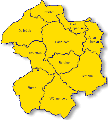
| Locations in the District PADERBORN (Source: Wikipedia) |
||||||||||||


| The following Ortsregister contains all places of the "Geschichtlichen Orts-Verzeichnisses" (GOV) of CompGen in PADERBORN. By activating the individual buttons in the four columns >Topo<, >SLUB<, >GOV< and >Meyers<, the geographical location of a place can be called up on a map from the geographical OpenTopoMap and Kartenforum or the place descriptions in the GOV-Ortsverzeichnis and Meyers Gazetteer. | ||||||||||||||||||||||||||
| A | B | C | D | E | F | G | H | I | J | K | L | M | N | O | P | Q | R | S | T | U | V | W | X | Y | Z | |
| Location | Distict | Location Typ | Coordinates | Topo | SLUB | GOV | Meyers | Community affiliation |
| Ahden | Paderborn | District | 51.6000 N 008.6200 E |  |
 |
 |
 |
Büren |
| Alfen | Paderborn | District | 51.6500 N 008.7000 E | |
|
|
|
Borchen |
| Almehof am Wehr | Paderborn | Place | 51.6800 N 008.7000 E | |
|
|
|
Paderborn |
| Altemeier | Paderborn | District | 51.6500 N 008.6300 E | |
|
|
|
Salzkotten |
| Altenbeken | Paderborn | Locality | 51.7700 N 008.9500 E | |
|
|
|
Altenbeken |
| Altenginger Mühle | Paderborn | Place | 51.7300 N 008.6700 E | |
|
|
|
Paderborn |
| Altensenne | Paderborn | Locality | 51.7700 N 008.6800 E | |
|
|
|
Paderborn |
| An der Almebrücke | Paderborn | Place | |
|
Altenbeken | |||
| Anreppen | Paderborn | City Subdistrict | 51.7300 N 008.5800 E | |
|
|
|
Delbrück |
| Asseln | Paderborn | District | 51.6500 N 008.9300 E | |
|
|
|
Lichtenau |
| Atteln | Paderborn | District | 51.5800 N 008.8000 E | |
|
|
|
Lichtenau |
| Auf dem Berge | Paderborn | Place | 51.7500 N 008.8300 E | |
|
|
|
Paderborn |
| Auf der Esche | Paderborn | Place | 51.5200 N 008.7300 E | |
|
|
|
Bad Wünnenberg |
| Auf'm Busche | Paderborn | Residential Area | 51.7700 N 008.5200 E | |
|
|
|
Delbrück |
| Location | Distict | Location Typ | Coordinates | Topo | SLUB | GOV | Meyers | Community affiliation |
| Barbruch | Paderborn | Place | 51.7200 N 008.5700 E | |
|
|
|
Delbrück |
| Barkhausen | Paderborn | District | 51.5200 N 008.5500 E | |
|
|
|
Büren |
| Barkhausen | Paderborn | Hamlet | 51.6800 N 008.7200 E | |
|
|
|
Paderborn |
| Beindelhof | Paderborn | Place | 51.7700 N 008.6800 E | |
|
|
|
Paderborn |
| Benhausen | Paderborn | City Subdistrict | 51.7406 N 008.8275 E | |
|
|
|
Paderborn |
| Bentfeld | Paderborn | City Subdistrict | 51.7300 N 008.6200 E | |
|
|
|
Delbrück |
| Berghof | Paderborn | District | 51.6000 N 008.6500 E | |
|
|
|
Büren |
| Bertelsfeld | Paderborn | Place | |
|
Delbrück | |||
| Blankenrode | Paderborn | City Subdistrict | 51.5386 N 008.9096 E | |
|
|
|
Lichtenau |
| Bleiwäsche | Paderborn | District | 51.4700 N 008.7000 E | |
|
|
|
Bad Wünnenberg |
| Blindeborn | Paderborn | Place | |
|
Lichtenau | |||
| Blockshof | Paderborn | District | 51.6500 N 008.5700 E | |
|
|
|
Salzkotten |
| Bohmkesiedlung | Paderborn | District | 51.6700 N 008.5800 E | |
|
|
|
Salzkotten |
| Böhner | Paderborn | District | 51.6500 N 008.6200 E | |
|
|
|
Salzkotten |
| Boke | Paderborn | City Subdistrict | 51.7200 N 008.5500 E | |
|
|
|
Delbrück |
| Bornerfeld | Paderborn | District | 51.6000 N 008.9000 E | |
|
|
|
Lichtenau |
| Bosenholz | Paderborn | District | 51.6300 N 008.6300 E | |
|
|
|
Salzkotten |
| Bracke | Paderborn | District | 51.6500 N 008.6200 E | |
|
|
|
Salzkotten |
| Brand | Paderborn | Residential Area | 51.7570 N 008.9500 E | |
|
|
|
Altenbeken |
| Braunsohle | Paderborn | Place | 51.7100 N 008.8780 E | |
|
|
|
Paderborn |
| Brenken | Paderborn | District | 51.5700 N 008.5800 E | |
|
|
|
Büren |
| Brenken | Paderborn | District | 51.5700 N 008.5800 E | |
|
|
|
Büren |
| Brenkerkrug | Paderborn | District | 51.5800 N 008.5800 E | |
|
|
|
Büren |
| Brockhof | Paderborn | Place | 51.7300 N 008.6500 E | |
|
|
|
Paderborn |
| Buchenhof | Paderborn | District | 51.6700 N 008.7300 E | |
|
|
|
Borchen |
| Buchholz | Paderborn | Place | 51.7300 N 008.8500 E | |
|
|
|
Paderborn |
| Buke | Paderborn | Locality | 51.7300 N 008.9300 E | |
|
|
|
Altenbeken |
| Buke Bahnhof | Paderborn | Residential Area | 51.7330 N 008.9500 E | |
|
|
|
Altenbeken |
| Bülheim | Paderborn | District | 51.6000 N 008.9300 E | |
|
|
|
Lichtenau |
| Büren | Paderborn | Locality | 51.5531 N 008.5588 E | |
|
|
|
Büren |
| Burghof | Paderborn | District | 51.6000 N 008.9300 E | |
|
|
|
Lichtenau |
| Busch | Paderborn | Village | 51.6500 N 008.8300 E | |
|
|
|
Borchen |
| Location | Distict | Location Typ | Coordinates | Topo | SLUB | GOV | Meyers | Community affiliation |
| Dahl | Paderborn | City Subdistrict | 51.6800 N 008.8300 E | |
|
|
|
Paderborn |
| Dedinghausen | Paderborn | Estate | 51.7960 N 008.8460 E | |
|
|
|
Lippstadt |
| Delbrück-Mitte | Paderborn | City Subdistrict | 51.7500 N 008.4700 E | |
|
|
|
Delbrück |
| Dirksmeier | Paderborn | Farmstead | 51.7500 N 008.6700 E | |
|
|
|
Paderborn |
| Donnerburg | Paderborn | District | 51.5500 N 008.5300 E | |
|
|
|
Büren |
| Dören | Paderborn | Residential Area | 51.7341 N 008.7807 E | |
|
|
|
Paderborn |
| Dörenhagen | Paderborn | District | 51.6700 N 008.8200 E | |
|
|
|
Borchen |
| Dörnerholz | Paderborn | Place | 51.7300 N 008.8000 E | |
|
|
|
Paderborn |
| Dreckburg | Paderborn | District | 51.6746 N 008.6221 E | |
|
|
|
Salzkotten |
| Dreihausen | Paderborn | Place | 51.7800 N 008.6800 E | |
|
|
|
Paderborn |
| Duhnetal | Paderborn | Place | |
|
Altenbeken | |||
| Dum | Paderborn | Place | |
|
Altenbeken | |||
| Dumberg | Paderborn | District | 51.7834 N 008.8474 E | |
|
|
|
Nachrodt-Wiblingwerde |
| Düsseler Höhe | Paderborn | Residential Area | 51.2610 N 007.0757 E | |
|
|
|
Wuppertal |
| Düsternsiek | Paderborn | Place | |
|
Xanten |
| Location | Distict | Location Typ | Coordinates | Topo | SLUB | GOV | Meyers | Community affiliation |
| Ebbinghausen | Paderborn | District | 51.6200 N 008.8200 E | |
|
|
|
Lichtenau |
| Ebers | Paderborn | District | 51.6000 N 008.6200 E | |
|
|
|
Büren |
| Edelborn | Paderborn | District | 51.5200 N 008.5500 E | |
|
|
|
Büren |
| Eggeringhausen | Paderborn | District | 51.6500 N 008.8300 E | |
|
|
|
Borchen |
| Eichsondern | Paderborn | Place | |
|
Büren | |||
| Eickhoff | Paderborn | District | 51.5500 N 008.5000 E | |
|
|
|
Büren |
| Eiferslohn | Paderborn | District | 51.6500 N 008.8000 E | |
|
|
|
Borchen |
| Eilern | Paderborn | Settlement | 51.5430 N 008.7700 E | |
|
|
|
Bad Wünnenberg |
| Eilernhof | Paderborn | Place | 51.5300 N 008.7700 E | |
|
|
|
Bad Wünnenberg |
| Elisenhof | Paderborn | District | 51.5416 N 008.8058 E | |
|
|
|
Bad Wünnenberg |
| Ellinghausen | Paderborn | District | 51.6300 N 008.6300 E | |
|
|
|
Salzkotten |
| Elsen | Paderborn | City Subdistrict | |
|
Paderborn | |||
| Elsen | Paderborn | District | 51.7338 N 008.6857 E | |
|
|
|
Paderborn |
| Elser Heide | Paderborn | Place | 51.7300 N 008.6700 E | |
|
|
|
Paderborn |
| Elser Holz | Paderborn | Place | 51.7195 N 008.6770 E | |
|
|
|
Paderborn |
| Emderwald | Paderborn | District | 51.6700 N 008.9300 E | |
|
|
|
Lichtenau |
| Enkhausen | Paderborn | District | 51.6700 N 008.5500 E | |
|
|
|
Salzkotten |
| Erpernburg | Paderborn | District | 51.5800 N 008.6000 E | |
|
|
|
Büren |
| Eschenbusch | Paderborn | Place | 51.7500 N 008.7000 E | |
|
|
|
Paderborn |
| Espen | Paderborn | District | 51.6300 N 008.6300 E | |
|
|
|
Salzkotten |
| Espenfeld | Paderborn | District | 51.6300 N 008.6300 E | |
|
|
|
Salzkotten |
| Etteln | Paderborn | District | 51.6200 N 008.7500 E | |
|
|
|
Borchen |
| Europa-Feriendorf | Paderborn | District | 51.5800 N 008.8200 E | |
|
|
|
Lichtenau |
| Ewers | Paderborn | District | 51.6500 N 008.6300 E | |
|
|
|
Salzkotten |
| Location | Distict | Location Typ | Coordinates | Topo | SLUB | GOV | Meyers | Community affiliation |
| Feldmershof | Paderborn | District | 51.6500 N 008.8200 E | |
|
|
|
Borchen |
| Felgenberg | Paderborn | Place | 51.4500 N 008.7700 E | |
|
|
|
Bad Wünnenberg |
| Finkengrund | Paderborn | District | 51.5000 N 008.5700 E | |
|
|
|
Büren |
| Fleyenhof | Paderborn | District | 51.6300 N 008.7500 E | |
|
|
|
Borchen |
| Fohlinghof | Paderborn | Place | 51.7300 N 008.7000 E | |
|
|
|
Paderborn |
| Forst | Paderborn | Residential Area | 51.7000 N 008.9300 E | |
|
|
|
Altenbeken |
| Forsthaus Bleiwäsche | Paderborn | Place | 51.4700 N 008.7000 E | |
|
|
|
Bad Wünnenberg |
| Forsthaus Habichtswald | Paderborn | Place | 51.7800 N 008.8000 E | |
|
|
|
Olsberg |
| Forsthaus Harth | Paderborn | District | 51.5000 N 008.5700 E | |
|
|
|
Büren |
| Forsthaus Lippspringer Wald | Paderborn | Farmstead | 51.7700 N 008.8700 E | |
|
|
|
Olsberg |
| Forsthaus Ringelstein | Paderborn | District | 51.5000 N 008.5700 E | |
|
|
|
Büren |
| Forsthaus Waldbach | Paderborn | Place | 51.5000 N 008.7000 E | |
|
|
|
Bad Wünnenberg |
| Frankenbach | Paderborn | District | 51.5000 N 008.6000 E | |
|
|
|
Büren |
| Friedrichsgrund | Paderborn | Place | 51.5300 N 008.7800 E | |
|
|
|
Bad Wünnenberg |
| Friedrichshütte | Paderborn | District | 51.6500 N 008.6700 E | |
|
|
|
Borchen |
| Frienberg | Paderborn | District | 51.5000 N 008.5700 E | |
|
|
|
Büren |
| Fründt | Paderborn | District | 51.5800 N 008.6300 E | |
|
|
|
Büren |
| Fündling | Paderborn | Farmstead | 51.5930 N 008.7100 E | |
|
|
|
Bad Wünnenberg |
| Fürstenberg | Paderborn | District | 51.5000 N 008.7300 E | |
|
|
|
Bad Wünnenberg |
| Location | Distict | Location Typ | Coordinates | Topo | SLUB | GOV | Meyers | Community affiliation |
| Gallihöhe | Paderborn | District | 51.6500 N 008.7200 E | |
|
|
|
Borchen |
| Gellinghausen | Paderborn | District | 51.6300 N 008.7300 E | |
|
|
|
Borchen |
| Gesseln | Paderborn | Place | |
|
Paderborn | |||
| Glashütte Fürstenberg | Paderborn | Houses | 51.4665 N 008.7516 E | |
|
|
|
Bad Wünnenberg |
| Graffeln | Paderborn | District | 51.6200 N 008.6300 E | |
|
|
|
Büren |
| Grundsteinheim | Paderborn | District | 51.6500 N 008.8700 E | |
|
|
|
Lichtenau |
| Grunewald | Paderborn | District | 51.5700 N 009.0000 E | |
|
|
|
Lichtenau |
| Gut Wandschicht | Paderborn | District | 51.6879 N 008.5897 E | |
|
|
|
Salzkotten |
| Gut Wohlbedacht | Paderborn | Place | 51.5000 N 008.8000 E | |
|
|
|
Bad Wünnenberg |
| Güthoff | Paderborn | District | 51.6000 N 008.8700 E | |
|
|
|
Lichtenau |
| Location | Distict | Location Typ | Coordinates | Topo | SLUB | GOV | Meyers | Community affiliation |
| Haaren | Paderborn | District | 51.5663 N 008.7283 E | |
|
|
|
Bad Wünnenberg |
| Hachhof | Paderborn | District | 51.8300 N 008.5500 E | |
|
|
|
Delbrück |
| Hagen | Paderborn | City Subdistrict | 51.7300 N 008.5000 E | |
|
|
|
Delbrück |
| Hakenberg | Paderborn | District | 51.6300 N 008.9300 E | |
|
|
|
Lichtenau |
| Harth | Paderborn | District | 51.5000 N 008.5800 E | |
|
|
|
Büren |
| Hartmühle | Paderborn | District | 51.6500 N 008.9300 E | |
|
|
|
Lichtenau |
| Haterbusch | Paderborn | District | 51.5500 N 008.5800 E | |
|
|
|
Büren |
| Haupt | Paderborn | District | 51.7800 N 008.6000 E | |
|
|
|
Delbrück |
| Haus Körtge | Paderborn | Place | |
|
Altenbeken | |||
| Haus Krötge | Paderborn | Place | 51.5200 N 008.8000 E | |
|
|
|
Bad Wünnenberg |
| Haus Thüle | Paderborn | District | 51.7000 N 008.5800 E | |
|
|
|
Salzkotten |
| Haus Widey | Paderborn | District | 51.6800 N 008.6300 E | |
|
|
|
Salzkotten |
| Haxterberg | Paderborn | District | 51.6700 N 008.7700 E | |
|
|
|
Borchen |
| Haxtergrund | Paderborn | Place | 51.6800 N 008.8000 E | |
|
|
|
Paderborn |
| Haxterhöhe | Paderborn | Place | 51.6800 N 008.7700 E | |
|
|
|
Paderborn |
| Heddinghausen | Paderborn | Farming Community | 51.7500 N 008.6200 E | |
|
|
|
Delbrück |
| Hegensdorf | Paderborn | District | 51.5200 N 008.6200 E | |
|
|
|
Büren |
| Heidehof | Paderborn | Place | 51.6800 N 008.8200 E | |
|
|
|
Paderborn |
| Heilgrund | Paderborn | District | 51.5700 N 008.9500 E | |
|
|
|
Lichtenau |
| Heimat | Paderborn | Place | 51.7800 N 008.8500 E | |
|
|
|
Bad Salzuflen |
| Heitwinkel | Paderborn | Colony | 51.7200 N 008.5500 E | |
|
|
|
Delbrück |
| Helmern | Paderborn | District | 51.5700 N 008.7500 E | |
|
|
|
Bad Wünnenberg |
| Heng | Paderborn | Farms | 51.7190 N 008.8800 E | |
|
|
|
Altenbeken |
| Hengkrug | Paderborn | Place | |
|
Altenbeken | |||
| Henglarn | Paderborn | District | 51.6000 N 008.7700 E | |
|
|
|
Lichtenau |
| Hensges-Neuhaus | Paderborn | Place | 51.2200 N 007.1300 E | |
|
|
|
Wuppertal |
| Herbram | Paderborn | District | 51.6700 N 008.9200 E | |
|
|
|
Lichtenau |
| Herbram-Wald | Paderborn | District | 51.6700 N 008.9500 E | |
|
|
|
Lichtenau |
| Herdt | Paderborn | District | 51.1700 N 006.3300 E | |
|
|
|
Mönchengladbach |
| Heyfeld | Paderborn | Place | |
|
Delbrück | |||
| Hof zum Brock | Paderborn | Estate | 51.6600 N 008.6100 E | |
|
|
|
Salzkotten |
| Hohenroden | Paderborn | District | 51.5200 N 008.6200 E | |
|
|
|
Büren |
| Holsen | Paderborn | Colony | 51.6800 N 008.5000 E | |
|
|
|
Salzkotten |
| Holser Heide | Paderborn | District | 51.6920 N 008.5260 E | |
|
|
|
Salzkotten |
| Holthausen | Paderborn | Estate | 51.5477 N 008.5442 E | |
|
|
|
Büren |
| Holtheim | Paderborn | District | 51.5700 N 008.9000 E | |
|
|
|
Lichtenau |
| Holthof | Paderborn | Farmstead | 51.7500 N 008.6700 E | |
|
|
|
Paderborn |
| Hölting | Paderborn | Place | 51.7700 N 008.7000 E | |
|
|
|
Paderborn |
| Hönkerfeld | Paderborn | District | 51.5000 N 008.5200 E | |
|
|
|
Büren |
| Hundsberg | Paderborn | District | 51.5300 N 008.6200 E | |
|
|
|
Büren |
| Hünecke | Paderborn | District | 51.6000 N 008.8700 E | |
|
|
|
Lichtenau |
| Husen | Paderborn | District | 51.5800 N 008.8200 E | |
|
|
|
Lichtenau |
| Hüser | Paderborn | Place | 51.5300 N 008.7000 E | |
|
|
|
Bad Wünnenberg |
| Location | Distict | Location Typ | Coordinates | Topo | SLUB | GOV | Meyers | Community affiliation |
| Iggenhausen | Paderborn | District | 51.6500 N 008.8800 E | |
|
|
|
Lichtenau |
| Im Goldgrund | Paderborn | Place | 51.7200 N 008.8000 E | |
|
|
|
Paderborn |
| Im Klee | Paderborn | Place | 51.7030 N 008.6894 E | |
|
|
|
Paderborn |
| Imkerfeld | Paderborn | Place | 51.6800 N 008.8200 E | |
|
|
|
Paderborn |
| In der Dune | Paderborn | Place | 51.7300 N 008.9000 E | |
|
|
|
Altenbeken |
| In der Grund | Paderborn | District | 51.6300 N 008.8300 E | |
|
|
|
Lichtenau |
| In der Hoffnung | Paderborn | Place | 51.2300 N 007.1200 E | |
|
|
|
Wuppertal |
| In der Klus | Paderborn | District | 51.5500 N 008.5000 E | |
|
|
|
Büren |
| Location | Distict | Location Typ | Coordinates | Topo | SLUB | GOV | Meyers | Community affiliation |
| Janischhof | Paderborn | District | 51.5700 N 008.5000 E | |
|
|
|
Büren |
| Location | Distict | Location Typ | Coordinates | Topo | SLUB | GOV | Meyers | Community affiliation |
| Kapellenberg | Paderborn | Place | |
|
Büren | |||
| Keddinghausen | Paderborn | Place | 51.5300 N 008.6000 E | |
|
|
|
Büren |
| Kirchboke | Paderborn | District | 51.7200 N 008.5700 E | |
|
|
|
Delbrück |
| Kirchborchen | Paderborn | District | 51.6500 N 008.7200 E | |
|
|
|
Borchen |
| Kleinenberg | Paderborn | District | 51.5700 N 008.9700 E | |
|
|
|
Lichtenau |
| Klein-Verne | Paderborn | Village | 51.6700 N 008.5800 E | |
|
|
|
Salzkotten |
| Klosterheide | Paderborn | Place | 51.5300 N 008.8300 E | |
|
|
|
Bad Wünnenberg |
| Klus | Paderborn | Residential Area | 51.5490 N 008.6700 E | |
|
|
|
Bad Wünnenberg |
| Klusheide | Paderborn | Place | 51.7500 N 008.7800 E | |
|
|
|
Paderborn |
| Klus-Okental | Paderborn | Place | |
|
Büren | |||
| Klusweide | Paderborn | Deserted Settlement | 51.7090 N 008.9900 E | |
|
|
|
Altenbeken |
| Knaup | Paderborn | District | 51.6500 N 008.7300 E | |
|
|
|
Borchen |
| Köllerickerfeld | Paderborn | District | 51.6000 N 008.8800 E | |
|
|
|
Lichtenau |
| Kolonie Widey | Paderborn | District | 51.6800 N 008.6500 E | |
|
|
|
Salzkotten |
| Krumme Grund | Paderborn | Place | 51.6800 N 008.8000 E | |
|
|
|
Paderborn |
| Kuhlen | Paderborn | Residential Area | 51.7650 N 008.4897 E | |
|
|
|
Delbrück |
| Kurte | Paderborn | District | 51.6300 N 008.8800 E | |
|
|
|
Lichtenau |
| Location | Distict | Location Typ | Coordinates | Topo | SLUB | GOV | Meyers | Community affiliation |
| Laake | Paderborn | District | 51.7700 N 008.5500 E | |
|
|
|
Delbrück |
| Langenhagen | Paderborn | District | 51.6700 N 008.5300 E | |
|
|
|
Salzkotten |
| Langenhof | Paderborn | Place | 51.7500 N 008.6500 E | |
|
|
|
Paderborn |
| Lauhof | Paderborn | District | 51.6800 N 008.5000 E | |
|
|
|
Salzkotten |
| Laumeskamp | Paderborn | District | 51.7500 N 008.5700 E | |
|
|
|
Delbrück |
| Laumes-Kamp | Paderborn | Place | |
|
Delbrück | |||
| Lehmstich | Paderborn | Place | 51.6800 N 008.6800 E | |
|
|
|
Paderborn |
| Lehrkind | Paderborn | District | 51.3200 N 007.5200 E | |
|
|
|
Hagen |
| Leiberg | Paderborn | District | 51.5200 N 008.6500 E | |
|
|
|
Bad Wünnenberg |
| Leste | Paderborn | Place | 51.7500 N 008.6000 E | |
|
|
|
Delbrück |
| Lesterberg | Paderborn | Place | 51.7500 N 008.6000 E | |
|
|
|
Delbrück |
| Letzter Heller | Paderborn | District | 51.6200 N 008.7200 E | |
|
|
|
Borchen |
| Lichtenau | Paderborn | District | 51.6169 N 008.8980 E | |
|
|
|
Lichtenau |
| Lipperhohl | Paderborn | District | 51.5500 N 008.5300 E | |
|
|
|
Büren |
| Lippling | Paderborn | City Subdistrict | 51.7800 N 008.5500 E | |
|
|
|
Delbrück |
| Lippstädter Bruch | Paderborn | Place | |
|
Delbrück | |||
| Lohhude | Paderborn | District | 51.7800 N 008.6200 E | |
|
|
|
Delbrück |
| Lohmann | Paderborn | District | 51.6500 N 008.6700 E | |
|
|
|
Borchen |
| Luchten | Paderborn | District | 51.5300 N 008.6200 E | |
|
|
|
Büren |
| Ludwigskrug | Paderborn | District | 51.6300 N 008.8700 E | |
|
|
|
Lichtenau |
| Location | Distict | Location Typ | Coordinates | Topo | SLUB | GOV | Meyers | Community affiliation |
| Maierwerke | Paderborn | Place | |
|
Balve | |||
| Mantinghausen | Paderborn | District | 51.7000 N 008.4800 E | |
|
|
|
Salzkotten |
| Marienloh | Paderborn | City Subdistrict | 51.7644 N 008.7869 E | |
|
|
|
Paderborn |
| Mark | Paderborn | District | 51.5700 N 008.5300 E | |
|
|
|
Büren |
| Marschallshagen | Paderborn | District | 51.5700 N 008.9000 E | |
|
|
|
Lichtenau |
| Mastbruch | Paderborn | Place | 51.7500 N 008.7200 E | |
|
|
|
Paderborn |
| Meerhof | Paderborn | Place | 51.7500 N 008.6500 E | |
|
|
|
Paderborn |
| Meierkamp | Paderborn | District | 51.6000 N 008.9000 E | |
|
|
|
Lichtenau |
| Menke | Paderborn | District | 51.6700 N 008.7200 E | |
|
|
|
Borchen |
| Mergelbreite | Paderborn | District | 51.6000 N 008.8800 E | |
|
|
|
Lichtenau |
| Messenberg | Paderborn | Place | |
|
Meschede | |||
| Michels | Paderborn | District | 51.6000 N 008.6200 E | |
|
|
|
Büren |
| Moese | Paderborn | Residential Area | 51.7630 N 008.4409 E | |
|
|
|
Delbrück |
| Molmschen | Paderborn | District | 51.4800 N 008.6000 E | |
|
|
|
Büren |
| Mühlenheide | Paderborn | Residential Area | 51.7372 N 008.4449 E | |
|
|
|
Delbrück |
| Mühlensenne | Paderborn | District | 51.7800 N 008.6500 E | |
|
|
|
Delbrück |
| Location | Distict | Location Typ | Coordinates | Topo | SLUB | GOV | Meyers | Community affiliation |
| Nesthausen | Paderborn | Residential Area | 51.7505 N 008.6901 E | |
|
|
|
Paderborn |
| Nesthauser Bruch | Paderborn | Place | 51.7300 N 008.6800 E | |
|
|
|
Paderborn |
| Neuböddeken | Paderborn | Place | 51.5800 N 008.7200 E | |
|
|
|
Bad Wünnenberg |
| Neuenbeken | Paderborn | City Subdistrict | 51.7300 N 008.8300 E | |
|
|
|
Paderborn |
| Neuenbrück | Paderborn | Building | 51.8182 N 008.5355 E | |
|
|
|
Delbrück |
| Neuenheerser Straße | Paderborn | Place | |
|
Altenbeken | |||
| Neuenriege | Paderborn | Place | |
|
Porta Westfalica | |||
| Neuhaus | Paderborn | District | 51.7444 N 008.7123 E | |
|
|
|
Paderborn |
| Niederntudorf | Paderborn | Locality | 51.6300 N 008.6700 E | |
|
|
|
Salzkotten |
| Nillies | Paderborn | District | 51.6500 N 008.7000 E | |
|
|
|
Borchen |
| Nimmer | Paderborn | District | 51.3000 N 007.5700 E | |
|
|
|
Hagen |
| Nöllenhammer | Paderborn | Residential Area | 51.2155 N 007.1253 E | |
|
|
|
Wuppertal |
| Nolte | Paderborn | District | 51.7200 N 008.6300 E | |
|
|
|
Delbrück |
| Nordborchen | Paderborn | District | 51.6700 N 008.7200 E | |
|
|
|
Borchen |
| Nordhagen | Paderborn | Village | 51.7700 N 008.5000 E | |
|
|
|
Delbrück |
| Nüsseken | Paderborn | Place | 51.7700 N 008.7000 E | |
|
|
|
Paderborn |
| Location | Distict | Location Typ | Coordinates | Topo | SLUB | GOV | Meyers | Community affiliation |
| Obere Feldmark | Paderborn | Place | 51.7700 N 008.9300 E | |
|
|
|
Altenbeken |
| Oberer Dullenhof | Paderborn | District | 51.6700 N 008.8000 E | |
|
|
|
Borchen |
| Oberfeld | Paderborn | District | 51.5700 N 008.5200 E | |
|
|
|
Büren |
| Obermühle | Paderborn | Place | 51.6800 N 008.8700 E | |
|
|
|
Altenbeken |
| Oberntudorf | Paderborn | Locality | 51.6300 N 008.6500 E | |
|
|
|
Salzkotten |
| Oberstadt | Paderborn | Place | 51.5000 N 008.6800 E | |
|
|
|
Bad Wünnenberg |
| Okental | Paderborn | District | 51.5300 N 008.6200 E | |
|
|
|
Büren |
| Ostenland | Paderborn | City Subdistrict | 51.7800 N 008.6200 E | |
|
|
|
Delbrück |
| Osterloh | Paderborn | Hamlet | 51.8000 N 008.5700 E | |
|
|
|
Delbrück |
| Location | Distict | Location Typ | Coordinates | Topo | SLUB | GOV | Meyers | Community affiliation |
| Paderborn-Kernstadt | Paderborn | City Subdistrict | 51.7152 N 008.7522 E | |
|
|
|
Paderborn |
| Pankoken Mühle | Paderborn | District | 51.6200 N 008.9200 E | |
|
|
|
Lichtenau |
| Pastorenbusch | Paderborn | District | 51.7700 N 008.5700 E | |
|
|
|
Delbrück |
| Pichtshof | Paderborn | District | 51.6700 N 008.8300 E | |
|
|
|
Borchen |
| Plümpe | Paderborn | Place | 51.5200 N 008.6800 E | |
|
|
|
Bad Wünnenberg |
| Pricken | Paderborn | District | 51.5500 N 008.6200 E | |
|
|
|
Büren |
| Priorei | Paderborn | District | 51.2800 N 007.5000 E | |
|
|
|
Hagen |
| Prövenholz | Paderborn | District | 51.5800 N 008.5000 E | |
|
|
|
Büren |
| Location | Distict | Location Typ | Coordinates | Topo | SLUB | GOV | Meyers | Community affiliation |
| Rath | Paderborn | District | 51.6700 N 008.7200 E | |
|
|
|
Borchen |
| Redingerhof | Paderborn | Estate | 51.7563 N 008.8444 E | |
|
|
|
Datteln |
| Reelsberg | Paderborn | Place | 51.7300 N 008.9500 E | |
|
|
|
Altenbeken |
| Riege | Paderborn | Residential Area | 51.7486 N 008.4913 E | |
|
|
|
Delbrück |
| Riege | Paderborn | District | 51.7500 N 008.5200 E | |
|
|
|
Delbrück |
| Ringboke | Paderborn | District | 51.7200 N 008.5500 E | |
|
|
|
Delbrück |
| Ringelsbruch | Paderborn | Place | |
|
Unna | |||
| Ringelstein | Paderborn | District | 51.5000 N 008.5700 E | |
|
|
|
Büren |
| Location | Distict | Location Typ | Coordinates | Topo | SLUB | GOV | Meyers | Community affiliation |
| Salvator Kolleg | Paderborn | Place | |
|
Hopsten | |||
| Salzkotten | Paderborn | Locality | 51.6712 N 008.6042 E | |
|
|
|
Salzkotten |
| Sande | Paderborn | District | 51.7616 N 008.6607 E | |
|
|
|
Paderborn |
| Sandhöfen | Paderborn | Place | 51.7500 N 008.6500 E | |
|
|
|
Paderborn |
| Scharmede | Paderborn | Locality | 51.7200 N 008.6200 E | |
|
|
|
Salzkotten |
| Scheppenbergsgrund | Paderborn | District | 51.5000 N 008.5500 E | |
|
|
|
Büren |
| Schloß Hamborn | Paderborn | Residential Area | 51.6500 N 008.7700 E | |
|
|
|
Borchen |
| Schloß Neuhaus | Paderborn | Place | 51.7419 N 008.7158 E | |
|
|
|
Paderborn |
| Schlüter | Paderborn | District | 51.5000 N 008.5200 E | |
|
|
|
Büren |
| Schnübbe | Paderborn | District | 51.6300 N 007.7700 E | |
|
|
|
Hamm |
| Schöning | Paderborn | City Subdistrict | 51.7800 N 008.4800 E | |
|
|
|
Delbrück |
| Schönthal | Paderborn | District | 51.6000 N 008.9700 E | |
|
|
|
Lichtenau |
| Schürenberg | Paderborn | District | 51.6000 N 008.6500 E | |
|
|
|
Büren |
| Schusters | Paderborn | Farmstead | 51.5582 N 008.6948 E | |
|
|
|
Bad Wünnenberg |
| Schützenwiese | Paderborn | Place | 51.4500 N 008.7300 E | |
|
|
|
Bad Wünnenberg |
| Schwanenkrug | Paderborn | District | 51.7200 N 008.5500 E | |
|
|
|
Delbrück |
| Schwaney | Paderborn | Locality | 51.7200 N 008.9300 E | |
|
|
|
Altenbeken |
| Schwelle | Paderborn | Locality | 51.7000 N 008.5200 E | |
|
|
|
Salzkotten |
| Seglingsheide | Paderborn | District | 51.7700 N 008.6000 E | |
|
|
|
Delbrück |
| Sehrt | Paderborn | District | 51.6300 N 008.7800 E | |
|
|
|
Borchen |
| Senne | Paderborn | Place | |
|
Verl | |||
| Sennelager | Paderborn | District | 51.7751 N 008.7133 E | |
|
|
|
Paderborn |
| Seskerbruch | Paderborn | Place | 51.7500 N 008.7800 E | |
|
|
|
Paderborn |
| Sicken | Paderborn | District | 51.5700 N 008.9200 E | |
|
|
|
Lichtenau |
| Siddinghausen | Paderborn | District | 51.5200 N 008.5200 E | |
|
|
|
Büren |
| Siep | Paderborn | Residential Area | 51.7710 N 008.9570 E | |
|
|
|
Altenbeken |
| Singermühle | Paderborn | District | 51.6500 N 008.9300 E | |
|
|
|
Lichtenau |
| Söhl | Paderborn | Place | 51.5500 N 008.7000 E | |
|
|
|
Bad Wünnenberg |
| Sprengel | Paderborn | District | 51.5300 N 008.5800 E | |
|
|
|
Büren |
| Sprenger | Paderborn | District | 51.6500 N 008.7300 E | |
|
|
|
Borchen |
| Stadteiche | Paderborn | Place | |
|
Salzkotten | |||
| Stadtteiche | Paderborn | District | 51.6700 N 008.6000 E | |
|
|
|
Salzkotten |
| Stapelsberg | Paderborn | Place | |
|
Wuppertal | |||
| Steffenmeier | Paderborn | Farmstead | 51.7500 N 008.7000 E | |
|
|
|
Paderborn |
| Steinbühl | Paderborn | District | 51.6200 N 008.9200 E | |
|
|
|
Lichtenau |
| Steinfeld | Paderborn | District | 51.5700 N 008.5800 E | |
|
|
|
Büren |
| Steinhausen | Paderborn | District | 51.5700 N 008.5000 E | |
|
|
|
Büren |
| Steinhorst | Paderborn | City Subdistrict | 51.8200 N 008.5300 E | |
|
|
|
Delbrück |
| Stelte | Paderborn | District | 51.6000 N 008.6200 E | |
|
|
|
Büren |
| Stierenhof | Paderborn | District | 51.5800 N 008.5800 E | |
|
|
|
Büren |
| Straß | Paderborn | Place | 50.8500 N 006.0700 E | |
|
|
|
Herzogenrath |
| Striepen | Paderborn | District | 51.6200 N 008.6000 E | |
|
|
|
Salzkotten |
| Sudhagen | Paderborn | Locality | 51.7300 N 008.5000 E | |
|
|
|
Delbrück |
| Sudhägerbruch | Paderborn | Place | |
|
Minden | |||
| Sudheim | Paderborn | Estate | 51.6066 N 008.9011 E | |
|
|
|
Lichtenau |
| Sudholt | Paderborn | District | 51.7500 N 008.4800 E | |
|
|
|
Delbrück |
| Sutern | Paderborn | Residential Area | 51.7449 N 008.4671 E | |
|
|
|
Delbrück |
| Location | Distict | Location Typ | Coordinates | Topo | SLUB | GOV | Meyers | Community affiliation |
| Taubengrund | Paderborn | Residential Area | 51.5870 N 008.7300 E | |
|
|
|
Bad Wünnenberg |
| Tegethof | Paderborn | District | 51.7500 N 008.5500 E | |
|
|
|
Delbrück |
| Thüle | Paderborn | Locality | |
|
Salzkotten | |||
| Thune | Paderborn | Colony | 51.7600 N 008.7100 E | |
|
|
|
Paderborn |
| Thunemühle | Paderborn | Place | 51.7500 N 008.7000 E | |
|
|
|
Paderborn |
| Thunhof | Paderborn | Place | 51.7500 N 008.7000 E | |
|
|
|
Paderborn |
| Location | Distict | Location Typ | Coordinates | Topo | SLUB | GOV | Meyers | Community affiliation |
| Untereichen | Paderborn | Colony | 51.7200 N 008.5000 E | |
|
|
|
Delbrück |
| Unterer Dullenhof | Paderborn | District | 51.6700 N 008.8000 E | |
|
|
|
Borchen |
| Untermühle | Paderborn | Place | 51.6800 N 008.8500 E | |
|
|
|
Paderborn |
| Unterstadt | Paderborn | Place | 51.5200 N 008.6800 E | |
|
|
|
Bad Wünnenberg |
| Upsprunge | Paderborn | Locality | 51.6500 N 008.6000 E | |
|
|
|
Salzkotten |
| Location | Distict | Location Typ | Coordinates | Topo | SLUB | GOV | Meyers | Community affiliation |
| Vennbruch | Paderborn | Residential Area | 51.7326 N 008.4244 E | |
|
|
|
Delbrück |
| Verlar | Paderborn | Locality | 51.6800 N 008.5000 E | |
|
|
|
Salzkotten |
| Verne | Paderborn | Locality | 51.6700 N 008.5700 E | |
|
|
|
Salzkotten |
| Vernerholz | Paderborn | District | 51.6700 N 008.5300 E | |
|
|
|
Salzkotten |
| Vielser Hof | Paderborn | District | 51.6500 N 008.6000 E | |
|
|
|
Salzkotten |
| Vielserhof | Paderborn | Place | |
|
Salzkotten | |||
| Vollbrexen | Paderborn | Outbuilding | 51.5000 N 008.6200 E | |
|
|
|
Büren |
| Vonnahme | Paderborn | District | 51.6500 N 008.6700 E | |
|
|
|
Salzkotten |
| Vor der Nadel | Paderborn | District | 51.5700 N 008.5000 E | |
|
|
|
Büren |
| Vossbein | Paderborn | Place | 51.7700 N 008.6700 E | |
|
|
|
Paderborn |
| Location | Distict | Location Typ | Coordinates | Topo | SLUB | GOV | Meyers | Community affiliation |
| Waldbach | Paderborn | Place | 51.5000 N 008.7000 E | |
|
|
|
Bad Wünnenberg |
| Walde | Paderborn | District | 51.7700 N 008.5300 E | |
|
|
|
Delbrück |
| Warthe | Paderborn | Estate | 51.6973 N 008.6832 E | |
|
|
|
Paderborn |
| Wasserspecke | Paderborn | District | 51.6000 N 008.8800 E | |
|
|
|
Lichtenau |
| Weiberg | Paderborn | District | 51.5000 N 008.5800 E | |
|
|
|
Büren |
| Weine | Paderborn | District | 51.5300 N 008.5200 E | |
|
|
|
Büren |
| Weltsöden | Paderborn | District | 51.6500 N 008.6300 E | |
|
|
|
Salzkotten |
| Westenholz | Paderborn | City Subdistrict | 51.7573 N 008.4724 E | |
|
|
|
Delbrück |
| Westenholzer Mühle | Paderborn | Residential Area | 51.7353 N 008.4561 E | |
|
|
|
Delbrück |
| Westerloh | Paderborn | District | |
|
Delbrück | |||
| Westerloher Mühle | Paderborn | Place | 51.8000 N 008.5200 E | |
|
|
|
Delbrück |
| Wewelsburg | Paderborn | District | 51.6000 N 008.6500 E | |
|
|
|
Büren |
| Wewer | Paderborn | City Subdistrict | 51.6800 N 008.7000 E | |
|
|
|
Paderborn |
| Widey | Paderborn | Place | |
|
Salzkotten | |||
| Wiebeler | Paderborn | Residential Area | 51.7510 N 008.4479 E | |
|
|
|
Delbrück |
| Wienekenhof | Paderborn | District | 51.6500 N 008.7000 E | |
|
|
|
Borchen |
| Wiethaupt | Paderborn | District | 51.7800 N 008.6200 E | |
|
|
|
Delbrück |
| Wilhelmsberg | Paderborn | Place | 51.7500 N 008.7000 E | |
|
|
|
Paderborn |
| Wilhelmsburg | Paderborn | Place | 51.6700 N 008.6800 E | |
|
|
|
Paderborn |
| Wilhelmshöhe | Paderborn | Place | 51.7200 N 008.7200 E | |
|
|
|
Paderborn |
| Winkhausen | Paderborn | District | 51.6800 N 008.5300 E | |
|
|
|
Salzkotten |
| Winterbergstraße | Paderborn | Place | |
|
Salzkotten | |||
| Wohnpark | Paderborn | Place | 51.5000 N 008.7300 E | |
|
|
|
Bad Wünnenberg |
| Wulfstal | Paderborn | District | 51.6200 N 008.5800 E | |
|
|
|
Salzkotten |
| Wulfsthal | Paderborn | Place | |
|
Salzkotten | |||
| Wünnenberg | Paderborn | District | 51.5182 N 008.6964 E | |
|
|
|
Bad Wünnenberg |
| Wüseke | Paderborn | Farmstead | 51.7700 N 008.6800 E | |
|
|
|
Paderborn |
|
||||||||||