|
|||||||||||
| District COESFELD - Locations Register - |
|||||||||||
|
|
|
||||||||||
| District COESFELD on the map of Germany (Source: Wikipedia) |
District COESFELD on the map of North Rhine-Westphalia (Source: Wikipedia) |
|||||||||||
|
||||||||||||
|
||||||||||||
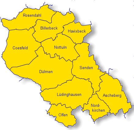
| Locations in the District COESFELD (Source: Wikipedia) |
||||||||||||


| The following Ortsregister contains all places of the "Geschichtlichen Orts-Verzeichnisses" (GOV) of CompGen in COESFELD. By activating the individual buttons in the four columns >Topo<, >SLUB<, >GOV< and >Meyers<, the geographical location of a place can be called up on a map from the geographical OpenTopoMap and Kartenforum or the place descriptions in the GOV-Ortsverzeichnis and Meyers Gazetteer. | ||||||||||||||||||||||||||
| A | B | C | D | E | F | G | H | I | J | K | L | M | N | O | P | Q | R | S | T | U | V | W | X | Y | Z | |
| Location | Distict | Location Typ | Coordinates | Topo | SLUB | GOV | Meyers | Community affiliation |
| Abbenhaus | Coesfeld | District | 52.0300 N 007.1800 E |  |
 |
 |
 |
Rosendahl |
| Ahlers | Coesfeld | Farmstead | 51.9298 N 007.2577 E | |
|
|
|
Coesfeld |
| Ahlers | Coesfeld | District | 51.9800 N 007.2800 E | |
|
|
|
Billerbeck |
| Ahlmer | Coesfeld | Farmstead | 52.0144 N 007.3399 E | |
|
|
|
Billerbeck |
| Ahmann | Coesfeld | Farmstead | 52.0236 N 007.4211 E | |
|
|
|
Billerbeck |
| Ahmann | Coesfeld | District | 51.8000 N 007.6000 E | |
|
|
|
Ascheberg |
| Aldenhövel | Coesfeld | Farming Community | 51.8200 N 007.5000 E | |
|
|
|
Lüdinghausen |
| Alstätte | Coesfeld | Farming Community | 51.9500 N 007.2800 E | |
|
|
|
Billerbeck |
| Altenbokum | Coesfeld | Farmstead | 51.8431 N 007.1884 E | |
|
|
|
Dülmen |
| Altendorf | Coesfeld | Farming Community | 51.7300 N 007.5500 E | |
|
|
|
Nordkirchen |
| Althoff | Coesfeld | Place | 51.9000 N 007.2000 E | |
|
|
|
Coesfeld |
| Altrogge | Coesfeld | Place | 51.9386 N 007.2368 E | |
|
|
|
Coesfeld |
| Alvingheide | Coesfeld | District | 51.9200 N 007.4800 E | |
|
|
|
Senden |
| Appelhülsen | Coesfeld | Municipal Part | 51.8979 N 007.4238 E | |
|
|
|
Nottuln |
| Arning | Coesfeld | Farmstead | 52.0318 N 007.3905 E | |
|
|
|
Billerbeck |
| Artmann | Coesfeld | Farmstead | 52.0316 N 007.3486 E | |
|
|
|
Billerbeck |
| Artmann | Coesfeld | Farmstead | 52.0249 N 007.3523 E | |
|
|
|
Billerbeck |
| Ascheberg | Coesfeld | Church Village | 51.7897 N 007.6201 E | |
|
|
|
Ascheberg |
| Aulendorf | Coesfeld | Farming Community | 52.0000 N 007.3300 E | |
|
|
|
Billerbeck |
| Austrup | Coesfeld | Place | 51.9200 N 007.2000 E | |
|
|
|
Coesfeld |
| Autermann | Coesfeld | Farmstead | 51.8380 N 007.1942 E | |
|
|
|
Dülmen |
| Averbeck | Coesfeld | Farmstead | 52.0177 N 007.3418 E | |
|
|
|
Billerbeck |
| Averesch | Coesfeld | District | 51.9500 N 007.3000 E | |
|
|
|
Nottuln |
| Averkamp | Coesfeld | Farmstead | 51.8862 N 007.3524 E | |
|
|
|
Dülmen |
| Averwellige | Coesfeld | Farmstead | 51.8110 N 007.5047 E | |
|
|
|
Lüdinghausen |
| Location | Distict | Location Typ | Coordinates | Topo | SLUB | GOV | Meyers | Community affiliation |
| Bagert | Coesfeld | District | 51.9300 N 007.2800 E | |
|
|
|
Nottuln |
| Barkhaus | Coesfeld | Farmstead | 51.7300 N 007.3700 E | |
|
|
|
Lüdinghausen |
| Baumberg | Coesfeld | Farming Community | 51.9500 N 007.3500 E | |
|
|
|
Nottuln |
| Baumer-Große Lordemann | Coesfeld | Farmstead | 52.0151 N 007.3860 E | |
|
|
|
Billerbeck |
| Bayer | Coesfeld | Place | 51.9000 N 007.2000 E | |
|
|
|
Coesfeld |
| Bayer-Jäger | Coesfeld | Place | 51.9000 N 007.1800 E | |
|
|
|
Coesfeld |
| Bechtrup | Coesfeld | Farming Community | 51.7800 N 007.4500 E | |
|
|
|
Lüdinghausen |
| Beckbauer | Coesfeld | Farmstead | 52.0053 N 007.4123 E | |
|
|
|
Billerbeck |
| Becker | Coesfeld | Farmstead | 51.7300 N 007.3700 E | |
|
|
|
Lüdinghausen |
| Beckmann | Coesfeld | Farmstead | 51.8000 N 007.3800 E | |
|
|
|
Lüdinghausen |
| Beckmann | Coesfeld | District | 51.8000 N 007.6200 E | |
|
|
|
Ascheberg |
| Beermann | Coesfeld | Farmstead | 51.9213 N 007.2662 E | |
|
|
|
Dülmen |
| Behler | Coesfeld | Place | 51.9200 N 007.1800 E | |
|
|
|
Coesfeld |
| Beifang | Coesfeld | District | 51.7200 N 007.6200 E | |
|
|
|
Nordkirchen |
| Beikel | Coesfeld | Farming Community | 51.8950 N 007.1740 E | |
|
|
|
Coesfeld |
| Beiring | Coesfeld | Place | 51.9000 N 007.2000 E | |
|
|
|
Coesfeld |
| Beiring-Reer | Coesfeld | Place | 51.9000 N 007.2200 E | |
|
|
|
Coesfeld |
| Bellerich | Coesfeld | Place | 51.9200 N 007.1800 E | |
|
|
|
Coesfeld |
| Benker | Coesfeld | District | 51.9500 N 007.2800 E | |
|
|
|
Billerbeck |
| Benning | Coesfeld | District | 51.9500 N 007.2200 E | |
|
|
|
Coesfeld |
| Benthof | Coesfeld | District | 51.7000 N 007.4000 E | |
|
|
|
Olfen |
| Berenbrock | Coesfeld | Farming Community | 51.7800 N 007.4000 E | |
|
|
|
Lüdinghausen |
| Berger | Coesfeld | Farming Community | 51.7260 N 007.5080 E | |
|
|
|
Nordkirchen |
| Berks | Coesfeld | District | 51.9500 N 007.2200 E | |
|
|
|
Coesfeld |
| Berning | Coesfeld | Farmstead | 51.8193 N 007.2525 E | |
|
|
|
Dülmen |
| Bertling | Coesfeld | Farmstead | 51.9177 N 007.2669 E | |
|
|
|
Dülmen |
| Bertling | Coesfeld | Farmstead | 51.8888 N 007.3323 E | |
|
|
|
Dülmen |
| Beuers | Coesfeld | Farmstead | 51.8369 N 007.4117 E | |
|
|
|
Dülmen |
| Bever-Gerling | Coesfeld | District | 51.9700 N 007.2500 E | |
|
|
|
Billerbeck |
| Bickmann | Coesfeld | District | 51.7000 N 007.7800 E | |
|
|
|
Hamm |
| Bickmann | Coesfeld | Farmstead | 51.8309 N 007.1967 E | |
|
|
|
Dülmen |
| Bils | Coesfeld | District | 51.9300 N 007.3000 E | |
|
|
|
Nottuln |
| Bleck | Coesfeld | Farming Community | 52.0000 N 007.1500 E | |
|
|
|
Rosendahl |
| Blömer (Kotten) | Coesfeld | Farmstead | 52.0060 N 007.3560 E | |
|
|
|
Billerbeck |
| Bockelsdorf | Coesfeld | Farming Community | 51.9800 N 007.3200 E | |
|
|
|
Billerbeck |
| Böckinghausen | Coesfeld | District | 51.9700 N 007.3200 E | |
|
|
|
Billerbeck |
| Bohmert | Coesfeld | District | 51.9300 N 007.2800 E | |
|
|
|
Nottuln |
| Bombeck | Coesfeld | Farming Community | 51.9700 N 007.3300 E | |
|
|
|
Billerbeck |
| Bontrup | Coesfeld | Farmstead | 51.8469 N 007.1770 E | |
|
|
|
Dülmen |
| Bontrup | Coesfeld | Farmstead | 51.8814 N 007.3535 E | |
|
|
|
Dülmen |
| Borchers | Coesfeld | Farmstead | 51.8519 N 007.1429 E | |
|
|
|
Dülmen |
| Börger | Coesfeld | District | 51.8000 N 007.5800 E | |
|
|
|
Ascheberg |
| Bösensell | Coesfeld | Village | 51.9000 N 007.4700 E | |
|
|
|
Senden |
| Böving | Coesfeld | Farmstead | 51.9919 N 007.3439 E | |
|
|
|
Billerbeck |
| Brathe | Coesfeld | District | 51.8200 N 007.3800 E | |
|
|
|
Dülmen |
| Bredenbeck | Coesfeld | District | 51.8800 N 007.4700 E | |
|
|
|
Senden |
| Brink | Coesfeld | Place | 51.9500 N 007.1500 E | |
|
|
|
Coesfeld |
| Brochtrup | Coesfeld | Place | |
|
Lüdinghausen | |||
| Brochtrup | Coesfeld | Farming Community | 51.7700 N 007.5200 E | |
|
|
|
Lüdinghausen |
| Brock | Coesfeld | Farming Community | 51.9500 N 007.4700 E | |
|
|
|
Havixbeck |
| Brock | Coesfeld | Farming Community | 52.0300 N 007.2000 E | |
|
|
|
Rosendahl |
| Brock | Coesfeld | District | 51.9000 N 007.4800 E | |
|
|
|
Senden |
| Brockbauerschaft | Coesfeld | Farming Community | |
|
Rosendahl | |||
| Brockmann | Coesfeld | Farmstead | 52.0256 N 007.4102 E | |
|
|
|
Billerbeck |
| Brockmann | Coesfeld | Place | 51.9200 N 007.2000 E | |
|
|
|
Coesfeld |
| Brocks | Coesfeld | Farmstead | 51.8482 N 007.1696 E | |
|
|
|
Dülmen |
| Bröer | Coesfeld | District | 51.6800 N 007.4500 E | |
|
|
|
Olfen |
| Bruneman | Coesfeld | Farmstead | 51.8081 N 007.5195 E | |
|
|
|
Lüdinghausen |
| Brüner (Kotten) | Coesfeld | Farmstead | 51.9970 N 007.3640 E | |
|
|
|
Billerbeck |
| Brunnemann | Coesfeld | Farmstead | 51.8881 N 007.3203 E | |
|
|
|
Dülmen |
| Bücker | Coesfeld | District | 51.8200 N 007.5800 E | |
|
|
|
Ascheberg |
| Bücker | Coesfeld | Place | 51.9300 N 007.1800 E | |
|
|
|
Coesfeld |
| Bücker | Coesfeld | Farmstead | 51.9181 N 007.2698 E | |
|
|
|
Dülmen |
| Bücker | Coesfeld | Farmstead | 51.8000 N 007.3800 E | |
|
|
|
Lüdinghausen |
| Budde | Coesfeld | Farmstead | 51.9060 N 007.2550 E | |
|
|
|
Dülmen |
| Budde Buxtrup | Coesfeld | Farmstead | 51.8996 N 007.3795 E | |
|
|
|
Nottuln |
| Buldern | Coesfeld | District | 51.8649 N 007.3695 E | |
|
|
|
Dülmen |
| Bunker | Coesfeld | Farmstead | 51.9052 N 007.2583 E | |
|
|
|
Dülmen |
| Bünker-Bergmann | Coesfeld | Farmstead | 51.8559 N 007.1872 E | |
|
|
|
Dülmen |
| Bußmann | Coesfeld | Farmstead | 51.9990 N 007.3479 E | |
|
|
|
Billerbeck |
| Buxtrup | Coesfeld | Farming Community | 51.9005 N 007.3880 E | |
|
|
|
Nottuln |
| Location | Distict | Location Typ | Coordinates | Topo | SLUB | GOV | Meyers | Community affiliation |
| Capelle | Coesfeld | District | |
|
Nordkirchen | |||
| Capelle | Coesfeld | Residential Area | 51.7312 N 007.5933 E | |
|
|
|
Nordkirchen |
| Location | Distict | Location Typ | Coordinates | Topo | SLUB | GOV | Meyers | Community affiliation |
| Daldrup | Coesfeld | District | 51.9500 N 007.3000 E | |
|
|
|
Nottuln |
| Daldrup-Farwick | Coesfeld | Farmstead | 51.8389 N 007.4198 E | |
|
|
|
Dülmen |
| Dalhaus | Coesfeld | Farmstead | 51.8000 N 007.3800 E | |
|
|
|
Lüdinghausen |
| Dals | Coesfeld | Place | 51.9200 N 007.1800 E | |
|
|
|
Coesfeld |
| Darfeld | Coesfeld | Municipal Part | 52.0200 N 007.2500 E | |
|
|
|
Rosendahl |
| Dartmann | Coesfeld | Farmstead | 51.8073 N 007.5151 E | |
|
|
|
Lüdinghausen |
| Darup | Coesfeld | Municipal Part | 51.9290 N 007.2960 E | |
|
|
|
Nottuln |
| Dasbecker Gartenstadt | Coesfeld | District | 51.7200 N 007.8200 E | |
|
|
|
Hamm |
| Davensberg | Coesfeld | District | 51.8200 N 007.5800 E | |
|
|
|
Ascheberg |
| Dechler | Coesfeld | Farmstead | 51.8808 N 007.3343 E | |
|
|
|
Dülmen |
| Deitert | Coesfeld | District | 51.9500 N 007.2300 E | |
|
|
|
Billerbeck |
| Dellbeck | Coesfeld | Farmstead | 51.8700 N 007.3858 E | |
|
|
|
Dülmen |
| Diekämper | Coesfeld | Farmstead | 51.8379 N 007.2120 E | |
|
|
|
Dülmen |
| Dilkaute | Coesfeld | Farmstead | 51.8122 N 007.2735 E | |
|
|
|
Dülmen |
| Dillkaute | Coesfeld | Farmstead | 51.8140 N 007.2940 E | |
|
|
|
Dülmen |
| Dinkheller | Coesfeld | District | 51.9500 N 007.2800 E | |
|
|
|
Billerbeck |
| Dirkmann | Coesfeld | District | 51.6800 N 007.3500 E | |
|
|
|
Olfen |
| Döbbeler | Coesfeld | Farmstead | 52.0222 N 007.4200 E | |
|
|
|
Billerbeck |
| Dorfbauerschaft | Coesfeld | District | 51.8300 N 007.5200 E | |
|
|
|
Senden |
| Dorfbauerschaft Merfeld | Coesfeld | Farming Community | |
|
Dülmen | |||
| Dörholt | Coesfeld | Farming Community | 51.9500 N 007.3000 E | |
|
|
|
Nottuln |
| Drees | Coesfeld | Farmstead | 51.8314 N 007.1928 E | |
|
|
|
Dülmen |
| Drees | Coesfeld | Place | 51.9000 N 007.1800 E | |
|
|
|
Coesfeld |
| Drees-Haake | Coesfeld | Farmstead | 51.8297 N 007.2052 E | |
|
|
|
Dülmen |
| Dreimann | Coesfeld | District | 51.7200 N 007.8000 E | |
|
|
|
Hamm |
| Dresmann | Coesfeld | Farmstead | 51.8111 N 007.4865 E | |
|
|
|
Lüdinghausen |
| Dreyer | Coesfeld | Farmstead | |
|
Lüdinghausen | |||
| Dülmen-Feldmark | Coesfeld | Farming Community | 51.8000 N 007.3000 E | |
|
|
|
Dülmen |
| Düpmann | Coesfeld | Farmstead | 51.8409 N 007.2107 E | |
|
|
|
Dülmen |
| Location | Distict | Location Typ | Coordinates | Topo | SLUB | GOV | Meyers | Community affiliation |
| Eckelt | Coesfeld | Farmstead | 52.0026 N 007.3731 E | |
|
|
|
Billerbeck |
| Eckrodt | Coesfeld | District | 51.9800 N 007.2800 E | |
|
|
|
Billerbeck |
| Eckrodt | Coesfeld | Place | 51.9200 N 007.2200 E | |
|
|
|
Coesfeld |
| Eickrodt (Tegederhof) | Coesfeld | Farmstead | 52.0151 N 007.3512 E | |
|
|
|
Billerbeck |
| Eilert | Coesfeld | Place | 51.9300 N 007.2000 E | |
|
|
|
Coesfeld |
| Einhaus | Coesfeld | Farmstead | 51.8503 N 007.2908 E | |
|
|
|
Dülmen |
| Eistrup | Coesfeld | Farmstead | 51.8851 N 007.3161 E | |
|
|
|
Dülmen |
| Eistrup-Wessendorf | Coesfeld | District | 51.9700 N 007.2300 E | |
|
|
|
Billerbeck |
| Elbert | Coesfeld | Farmstead | 51.8349 N 007.2035 E | |
|
|
|
Dülmen |
| Elfering | Coesfeld | Place | 51.9200 N 007.2200 E | |
|
|
|
Coesfeld |
| Elsbecker | Coesfeld | Place | 51.9000 N 007.2200 E | |
|
|
|
Coesfeld |
| Elskämper | Coesfeld | Farmstead | 51.8348 N 007.1905 E | |
|
|
|
Dülmen |
| Elvert | Coesfeld | Farming Community | |
|
Lüdinghausen | |||
| Emkum | Coesfeld | Farming Community | 51.7500 N 007.3500 E | |
|
|
|
Lüdinghausen |
| Emmerich | Coesfeld | Farmstead | 51.9284 N 007.2693 E | |
|
|
|
Nottuln |
| Engsterstein | Coesfeld | Farmstead | 51.8172 N 007.2736 E | |
|
|
|
Dülmen |
| Enseling | Coesfeld | District | 52.0300 N 007.1800 E | |
|
|
|
Rosendahl |
| Entrup | Coesfeld | Place | 51.9300 N 007.2000 E | |
|
|
|
Coesfeld |
| Entrup | Coesfeld | District | 51.8300 N 007.6200 E | |
|
|
|
Ascheberg |
| Ermen | Coesfeld | Farming Community | 51.7300 N 007.4800 E | |
|
|
|
Lüdinghausen |
| Eschkötter (Kotten) | Coesfeld | Farmstead | 52.0117 N 007.4045 E | |
|
|
|
Billerbeck |
| Esking | Coesfeld | Farming Community | |
|
Billerbeck | |||
| Esking (Schulzenhof) | Coesfeld | Farmstead | 52.0182 N 007.3566 E | |
|
|
|
Billerbeck |
| Espeter | Coesfeld | Farmstead | 51.8417 N 007.1924 E | |
|
|
|
Dülmen |
| Ester-Heuing | Coesfeld | Farmstead | 52.0300 N 007.3612 E | |
|
|
|
Billerbeck |
| Eversum | Coesfeld | District | 51.7000 N 007.3000 E | |
|
|
|
Olfen |
| Ewelt | Coesfeld | Farmstead | 51.9200 N 007.2700 E | |
|
|
|
Nottuln |
| Ewers | Coesfeld | Place | 51.9200 N 007.1800 E | |
|
|
|
Coesfeld |
| Location | Distict | Location Typ | Coordinates | Topo | SLUB | GOV | Meyers | Community affiliation |
| Falkenrath | Coesfeld | Place | 51.3000 N 007.2300 E | |
|
|
|
Wuppertal |
| Fallbrügge | Coesfeld | Farmstead | 51.8944 N 007.2626 E | |
|
|
|
Dülmen |
| Fallbrügge | Coesfeld | Place | 51.9200 N 007.2200 E | |
|
|
|
Coesfeld |
| Fallbrügge-Briede | Coesfeld | Farmstead | 51.8965 N 007.2772 E | |
|
|
|
Dülmen |
| Faltmann | Coesfeld | District | 51.9700 N 007.2700 E | |
|
|
|
Billerbeck |
| Fasselt | Coesfeld | Farmstead | 51.8876 N 007.3252 E | |
|
|
|
Dülmen |
| Fehmer | Coesfeld | District | 51.9300 N 007.2800 E | |
|
|
|
Nottuln |
| Fehmer | Coesfeld | District | 51.9700 N 007.2700 E | |
|
|
|
Billerbeck |
| Feldhaus | Coesfeld | District | 51.9500 N 007.2200 E | |
|
|
|
Coesfeld |
| Fels | Coesfeld | Farmstead | 51.9232 N 007.2768 E | |
|
|
|
Nottuln |
| Flamschen | Coesfeld | Place | 51.9200 N 007.1300 E | |
|
|
|
Coesfeld |
| Fliß | Coesfeld | District | 51.9500 N 007.2800 E | |
|
|
|
Billerbeck |
| Franke | Coesfeld | Farmstead | 51.8876 N 007.3252 E | |
|
|
|
Dülmen |
| Frerich | Coesfeld | Farmstead | 51.8490 N 007.4163 E | |
|
|
|
Dülmen |
| Frerick | Coesfeld | Farmstead | 51.8369 N 007.1934 E | |
|
|
|
Dülmen |
| Froning (Kotten) | Coesfeld | Farmstead | 52.0098 N 007.3862 E | |
|
|
|
Billerbeck |
| Füssener | Coesfeld | Farmstead | 51.8417 N 007.2132 E | |
|
|
|
Dülmen |
| Füßner | Coesfeld | Farmstead | 51.8424 N 007.1717 E | |
|
|
|
Dülmen |
| Location | Distict | Location Typ | Coordinates | Topo | SLUB | GOV | Meyers | Community affiliation |
| Gantweg | Coesfeld | Farming Community | 51.9800 N 007.2800 E | |
|
|
|
Billerbeck |
| Gaupel | Coesfeld | Place | 51.9700 N 007.1800 E | |
|
|
|
Coesfeld |
| Gausling | Coesfeld | Place | 51.9200 N 007.1800 E | |
|
|
|
Coesfeld |
| Geisbeck | Coesfeld | District | 51.6800 N 007.5500 E | |
|
|
|
Nordkirchen |
| Geitendorf | Coesfeld | Farming Community | 52.0300 N 007.2300 E | |
|
|
|
Rosendahl |
| Gelmann | Coesfeld | District | 51.8000 N 007.3300 E | |
|
|
|
Dülmen |
| Gelschefarth | Coesfeld | Farmstead | 51.8477 N 007.1726 E | |
|
|
|
Dülmen |
| Gelsterkamp | Coesfeld | Farmstead | 51.8885 N 007.2757 E | |
|
|
|
Dülmen |
| Gennerich | Coesfeld | Farming Community | 51.9700 N 007.4000 E | |
|
|
|
Havixbeck |
| Gerding | Coesfeld | Place | 51.9200 N 007.2200 E | |
|
|
|
Coesfeld |
| Gerding | Coesfeld | District | 51.9300 N 007.2800 E | |
|
|
|
Nottuln |
| Gerleve | Coesfeld | District | 51.9464 N 007.2367 E | |
|
|
|
Billerbeck |
| Gerleve | Coesfeld | Farming Community | 51.9400 N 007.2500 E | |
|
|
|
Billerbeck |
| Gerleve | Coesfeld | Monastery | 51.9460 N 007.2375 E | |
|
|
|
Billerbeck |
| Gerleve-Auling | Coesfeld | Farmstead | 52.0143 N 007.3589 E | |
|
|
|
Billerbeck |
| Gesting | Coesfeld | District | 51.9000 N 007.2700 E | |
|
|
|
Dülmen |
| Gettrup | Coesfeld | District | 51.8300 N 007.4800 E | |
|
|
|
Senden |
| Gladbeck | Coesfeld | Farming Community | 51.9200 N 007.2800 E | |
|
|
|
Nottuln |
| Glöe | Coesfeld | District | 51.9500 N 007.2700 E | |
|
|
|
Billerbeck |
| Göckener | Coesfeld | Farmstead | 51.8575 N 007.1756 E | |
|
|
|
Dülmen |
| Göckener | Coesfeld | Farmstead | 51.8392 N 007.1914 E | |
|
|
|
Dülmen |
| Gövert | Coesfeld | Farmstead | 52.0159 N 007.3395 E | |
|
|
|
Billerbeck |
| Goxel | Coesfeld | Place | 51.9300 N 007.1200 E | |
|
|
|
Coesfeld |
| Gr. Uhlenbrock | Coesfeld | Farmstead | 51.8282 N 007.4156 E | |
|
|
|
Lüdinghausen |
| Greb | Coesfeld | District | 51.9500 N 007.2800 E | |
|
|
|
Billerbeck |
| Greskämper | Coesfeld | Farmstead | 51.8441 N 007.1701 E | |
|
|
|
Dülmen |
| Greve | Coesfeld | Farmstead | |
|
Lüdinghausen | |||
| Greving | Coesfeld | Farmstead | 52.0135 N 007.3609 E | |
|
|
|
Billerbeck |
| Große Aldenhovel | Coesfeld | Farmstead | 51.8094 N 007.5050 E | |
|
|
|
Lüdinghausen |
| Große Boekman | Coesfeld | Farmstead | 51.7948 N 007.4941 E | |
|
|
|
Lüdinghausen |
| Große Daldrup | Coesfeld | Farmstead | 51.9950 N 007.3262 E | |
|
|
|
Billerbeck |
| Große Encking | Coesfeld | Farmstead | 51.9993 N 007.3815 E | |
|
|
|
Billerbeck |
| Große Herzog | Coesfeld | Farmstead | 51.8859 N 007.3389 E | |
|
|
|
Dülmen |
| Große Ostendorf | Coesfeld | Farmstead | 52.0167 N 007.3451 E | |
|
|
|
Billerbeck |
| Grote-Westrich | Coesfeld | Farmstead | 51.8437 N 007.1922 E | |
|
|
|
Dülmen |
| Grothues | Coesfeld | District | 51.8500 N 007.3700 E | |
|
|
|
Dülmen |
| Growe | Coesfeld | Farmstead | 51.8343 N 007.1976 E | |
|
|
|
Dülmen |
| Gut Eversum | Coesfeld | District | 51.7000 N 007.3200 E | |
|
|
|
Olfen |
| Gut Middendorf | Coesfeld | District | 51.9700 N 007.2500 E | |
|
|
|
Billerbeck |
| Location | Distict | Location Typ | Coordinates | Topo | SLUB | GOV | Meyers | Community affiliation |
| Hagelschuer | Coesfeld | Farmstead | 51.7300 N 007.3700 E | |
|
|
|
Olfen |
| Haitmann | Coesfeld | Farmstead | 51.8458 N 007.3957 E | |
|
|
|
Dülmen |
| Hamern | Coesfeld | Farming Community | 51.9800 N 007.2500 E | |
|
|
|
Billerbeck |
| Hämmermark | Coesfeld | Farming Community | 51.9880 N 007.2970 E | |
|
|
|
Billerbeck |
| Hangwerfeld | Coesfeld | District | 51.9700 N 007.4200 E | |
|
|
|
Havixbeck |
| Hanloer Mark | Coesfeld | District | 51.9300 N 007.3000 E | |
|
|
|
Nottuln |
| Hanning | Coesfeld | Farmstead | 51.8256 N 007.4101 E | |
|
|
|
Lüdinghausen |
| Hanrorup | Coesfeld | Farming Community | |
|
Dülmen | |||
| Harle | Coesfeld | Place | 51.9300 N 007.1800 E | |
|
|
|
Coesfeld |
| Hasbrink | Coesfeld | District | 51.6700 N 007.4000 E | |
|
|
|
Olfen |
| Hastehausen | Coesfeld | Farming Community | 51.9300 N 007.2800 E | |
|
|
|
Nottuln |
| Haus Alvinghof | Coesfeld | Estate | 51.9256 N 007.4874 E | |
|
|
|
Senden |
| Haus Byink | Coesfeld | Estate | 51.8119 N 007.5928 E | |
|
|
|
Ascheberg |
| Haus Hamern | Coesfeld | Building | 51.9640 N 007.2780 E | |
|
|
|
Billerbeck |
| Haus Konerding | Coesfeld | Farmstead | 51.9969 N 007.3501 E | |
|
|
|
Billerbeck |
| Haus Rauschenburg | Coesfeld | District | 51.6700 N 007.3500 E | |
|
|
|
Olfen |
| Haus Romberg | Coesfeld | District | 51.8000 N 007.5800 E | |
|
|
|
Ascheberg |
| Haus Rorup | Coesfeld | Farmstead | 51.8984 N 007.2656 E | |
|
|
|
Dülmen |
| Haus Runde | Coesfeld | Farmstead | 52.0069 N 007.3607 E | |
|
|
|
Billerbeck |
| Haus Sandfort | Coesfeld | District | 51.6800 N 007.4000 E | |
|
|
|
Olfen |
| Haus Schwickering | Coesfeld | Farmstead | 51.9019 N 007.2468 E | |
|
|
|
Dülmen |
| Haus Steinhorst | Coesfeld | District | 51.8200 N 007.6200 E | |
|
|
|
Ascheberg |
| Hausdülmen | Coesfeld | Village | 51.8108 N 007.2530 E | |
|
|
|
Dülmen |
| Hautmann-Knüver | Coesfeld | Place | 51.8500 N 007.1000 E | |
|
|
|
Coesfeld |
| Havixbeck | Coesfeld | Village | 51.9762 N 007.4120 E | |
|
|
|
Havixbeck |
| Havixbeck | Coesfeld | Estate | 51.9713 N 007.4093 E | |
|
|
|
Havixbeck |
| Hecker | Coesfeld | District | 51.8500 N 007.5500 E | |
|
|
|
Senden |
| Hegemer | Coesfeld | District | 51.7700 N 007.6000 E | |
|
|
|
Ascheberg |
| Hegemerbauerschaft | Coesfeld | Place | |
|
Ascheberg | |||
| Hegerort | Coesfeld | Farming Community | 52.0000 N 007.0800 E | |
|
|
|
Rosendahl |
| Heidman | Coesfeld | Farmstead | 51.8201 N 007.4827 E | |
|
|
|
Lüdinghausen |
| Heitmann | Coesfeld | Place | 51.9200 N 007.1800 E | |
|
|
|
Coesfeld |
| Heller | Coesfeld | Farming Community | 51.9000 N 007.4000 E | |
|
|
|
Nottuln |
| Hellerberg | Coesfeld | Farmstead | 51.9089 N 007.2503 E | |
|
|
|
Dülmen |
| Helming | Coesfeld | Farmstead | 51.7300 N 007.3700 E | |
|
|
|
Olfen |
| Heming | Coesfeld | District | 51.9500 N 007.3000 E | |
|
|
|
Nottuln |
| Hennewich | Coesfeld | Farming Community | 52.0300 N 007.2800 E | |
|
|
|
Rosendahl |
| Herkentrup | Coesfeld | Farming Community | 51.9700 N 007.4500 E | |
|
|
|
Havixbeck |
| Hermanik | Coesfeld | Farmstead | 51.7700 N 007.4200 E | |
|
|
|
Lüdinghausen |
| Herteler | Coesfeld | Farming Community | 51.9100 N 007.1740 E | |
|
|
|
Coesfeld |
| Hesker | Coesfeld | District | 51.9800 N 007.3000 E | |
|
|
|
Billerbeck |
| Hesker | Coesfeld | Farmstead | 51.8415 N 007.2050 E | |
|
|
|
Dülmen |
| Hesper | Coesfeld | District | 51.9500 N 007.2200 E | |
|
|
|
Billerbeck |
| Hesselt | Coesfeld | District | 52.0300 N 007.1700 E | |
|
|
|
Rosendahl |
| Hiddingsel | Coesfeld | Farming Community | |
|
Dülmen | |||
| Hiddingsel | Coesfeld | Village | 51.8367 N 007.4028 E | |
|
|
|
Dülmen |
| Hilgenberg | Coesfeld | Farmstead | 51.8450 N 007.1974 E | |
|
|
|
Dülmen |
| Hinsken | Coesfeld | Farmstead | 51.8445 N 007.2101 E | |
|
|
|
Dülmen |
| Hinz | Coesfeld | District | 51.8300 N 007.6000 E | |
|
|
|
Ascheberg |
| Höckensfeld | Coesfeld | Place | 51.9200 N 007.2300 E | |
|
|
|
Coesfeld |
| Höfen | Coesfeld | District | 50.5322 N 006.2549 E | |
|
|
|
Monschau |
| Hohenholte | Coesfeld | District | 51.9800 N 007.4700 E | |
|
|
|
Havixbeck |
| Hohenholte (Stift) | Coesfeld | Monastery | 51.9969 N 007.4600 E | |
|
|
|
Havixbeck |
| Hölker | Coesfeld | District | 51.9500 N 007.3000 E | |
|
|
|
Nottuln |
| Hölker (Kotten) | Coesfeld | Farmstead | 52.0200 N 007.3500 E | |
|
|
|
Billerbeck |
| Hölper | Coesfeld | District | 51.7300 N 007.3700 E | |
|
|
|
Olfen |
| Holsterbrink | Coesfeld | Farming Community | |
|
Dülmen | |||
| Holthausen | Coesfeld | Farming Community | 51.9700 N 007.3000 E | |
|
|
|
Billerbeck |
| Holthausen | Coesfeld | Place | 52.0200 N 007.3700 E | |
|
|
|
Billerbeck |
| Holtrup | Coesfeld | District | 51.8500 N 007.4700 E | |
|
|
|
Senden |
| Holtwick | Coesfeld | Municipal Part | 52.0000 N 007.1200 E | |
|
|
|
Rosendahl |
| Holtwick Riege | Coesfeld | Farming Community | 51.9800 N 007.1200 E | |
|
|
|
Rosendahl |
| Homoet | Coesfeld | Farmstead | 52.0120 N 007.3260 E | |
|
|
|
Billerbeck |
| Höpingen | Coesfeld | Farming Community | 52.0300 N 007.3200 E | |
|
|
|
Rosendahl |
| Horst | Coesfeld | Farming Community | 51.9000 N 007.3500 E | |
|
|
|
Nottuln |
| Hörster | Coesfeld | District | 51.8200 N 007.5800 E | |
|
|
|
Ascheberg |
| Hörsting | Coesfeld | Place | 51.9000 N 007.1800 E | |
|
|
|
Coesfeld |
| Horstmann | Coesfeld | District | 51.8200 N 007.5800 E | |
|
|
|
Senden |
| Horstrup | Coesfeld | Farmstead | 51.8730 N 007.4088 E | |
|
|
|
Dülmen |
| Hörstrup | Coesfeld | Farmstead | 51.7131 N 007.5716 E | |
|
|
|
Nordkirchen |
| Hövel | Coesfeld | Municipal Part | 51.9045 N 007.3288 E | |
|
|
|
Nottuln |
| Höven | Coesfeld | Farming Community | 51.9800 N 007.1500 E | |
|
|
|
Rosendahl |
| Hövener | Coesfeld | Farmstead | 52.0150 N 007.3300 E | |
|
|
|
Billerbeck |
| Hullermann | Coesfeld | Farmstead | 51.8149 N 007.2448 E | |
|
|
|
Dülmen |
| Hülshoff | Coesfeld | Castle | 51.9716 N 007.5038 E | |
|
|
|
Havixbeck |
| Hülsmann | Coesfeld | District | 51.6800 N 007.9200 E | |
|
|
|
Hamm |
| Hülsmann | Coesfeld | Farmstead | 51.8558 N 007.1947 E | |
|
|
|
Dülmen |
| Hülsmann | Coesfeld | Farmstead | 51.7300 N 007.3700 E | |
|
|
|
Lüdinghausen |
| Hülsmann | Coesfeld | Farmstead | 51.8768 N 007.3364 E | |
|
|
|
Dülmen |
| Hummelt | Coesfeld | District | 51.8000 N 007.6200 E | |
|
|
|
Ascheberg |
| Hunke | Coesfeld | District | 51.9500 N 007.2500 E | |
|
|
|
Billerbeck |
| Hüppe | Coesfeld | Farmstead | 51.8498 N 007.1731 E | |
|
|
|
Dülmen |
| Hüser | Coesfeld | Farmstead | 51.7300 N 007.3700 E | |
|
|
|
Lüdinghausen |
| Hustert | Coesfeld | Farmstead | 51.8393 N 007.1860 E | |
|
|
|
Dülmen |
| Hüynck | Coesfeld | District | 51.9700 N 007.2200 E | |
|
|
|
Billerbeck |
| Location | Distict | Location Typ | Coordinates | Topo | SLUB | GOV | Meyers | Community affiliation |
| Imgenbroich | Coesfeld | District | 50.5700 N 006.2500 E | |
|
|
|
Monschau |
| Isfeld | Coesfeld | Place | 51.9200 N 007.1800 E | |
|
|
|
Coesfeld |
| Isfort | Coesfeld | District | 52.0300 N 007.2000 E | |
|
|
|
Rosendahl |
| Location | Distict | Location Typ | Coordinates | Topo | SLUB | GOV | Meyers | Community affiliation |
| Janning | Coesfeld | Farmstead | 52.0100 N 007.3788 E | |
|
|
|
Billerbeck |
| Jasper | Coesfeld | Farmstead | 51.8429 N 007.1875 E | |
|
|
|
Dülmen |
| Jasper (J. uffr Heide) | Coesfeld | Farmstead | |
|
Lüdinghausen | |||
| Jeiler | Coesfeld | Farmstead | 51.8519 N 007.4132 E | |
|
|
|
Dülmen |
| Location | Distict | Location Typ | Coordinates | Topo | SLUB | GOV | Meyers | Community affiliation |
| Kabrede | Coesfeld | District | 51.8200 N 007.5800 E | |
|
|
|
Senden |
| Kalksbeck | Coesfeld | Place | 51.9200 N 007.1800 E | |
|
|
|
Coesfeld |
| Kamlage | Coesfeld | District | 51.8300 N 007.5700 E | |
|
|
|
Ascheberg |
| Kampelmann | Coesfeld | District | 51.9500 N 007.2200 E | |
|
|
|
Coesfeld |
| Kemming | Coesfeld | District | 51.8300 N 007.3800 E | |
|
|
|
Dülmen |
| Kemper | Coesfeld | District | 51.9800 N 007.2800 E | |
|
|
|
Billerbeck |
| Kentrup | Coesfeld | District | 52.0200 N 007.3800 E | |
|
|
|
Billerbeck |
| Kersting | Coesfeld | District | 51.7300 N 007.3700 E | |
|
|
|
Olfen |
| Kesselmann | Coesfeld | District | 51.9700 N 007.2700 E | |
|
|
|
Billerbeck |
| Kimmel | Coesfeld | District | 51.8000 N 007.5800 E | |
|
|
|
Ascheberg |
| Kleine Herzog | Coesfeld | Farmstead | 51.8879 N 007.3379 E | |
|
|
|
Dülmen |
| Kley | Coesfeld | District | 51.9000 N 007.4500 E | |
|
|
|
Senden |
| Kleykamp | Coesfeld | District | 51.8000 N 007.6200 E | |
|
|
|
Ascheberg |
| Kloster Maria-Hamicolt | Coesfeld | Monastery | 51.8905 N 007.2936 E | |
|
|
|
Dülmen |
| Klüsener | Coesfeld | Farmstead | 51.8575 N 007.1225 E | |
|
|
|
Coesfeld |
| Klye | Coesfeld | Place | |
|
Coesfeld | |||
| Kneuper | Coesfeld | Farmstead | 51.8419 N 007.1825 E | |
|
|
|
Dülmen |
| Kock | Coesfeld | Farmstead | 51.8416 N 007.1969 E | |
|
|
|
Dülmen |
| Koddebusch | Coesfeld | Farmstead | 51.7995 N 007.4966 E | |
|
|
|
Lüdinghausen |
| Kökelsum | Coesfeld | District | 51.7200 N 007.3500 E | |
|
|
|
Olfen |
| Koners | Coesfeld | Place | 51.9000 N 007.2200 E | |
|
|
|
Coesfeld |
| König | Coesfeld | Farmstead | 51.9311 N 007.2697 E | |
|
|
|
Nottuln |
| Konnermann | Coesfeld | Farmstead | 51.8874 N 007.3408 E | |
|
|
|
Dülmen |
| Konzen | Coesfeld | District | 50.5800 N 006.2500 E | |
|
|
|
Monschau |
| Kortmann | Coesfeld | Farmstead | 52.0165 N 007.3958 E | |
|
|
|
Billerbeck |
| Kortstiege | Coesfeld | Farmstead | 51.8000 N 007.4000 E | |
|
|
|
Lüdinghausen |
| Köster | Coesfeld | Farmstead | 51.7300 N 007.3700 E | |
|
|
|
Lüdinghausen |
| Krampe | Coesfeld | Farmstead | 52.0033 N 007.3747 E | |
|
|
|
Billerbeck |
| Kreimer | Coesfeld | Farmstead | 52.0289 N 007.4071 E | |
|
|
|
Billerbeck |
| Kreuzbauerschaft | Coesfeld | District | 51.8200 N 007.5500 E | |
|
|
|
Senden |
| Kreuznacht | Coesfeld | Farmstead | 51.8337 N 007.2022 E | |
|
|
|
Dülmen |
| Kruckendrup | Coesfeld | Farmstead | 51.8212 N 007.4790 E | |
|
|
|
Lüdinghausen |
| Kuban | Coesfeld | Place | 51.9200 N 007.2300 E | |
|
|
|
Coesfeld |
| Kuhmann | Coesfeld | Farmstead | 51.8466 N 007.2089 E | |
|
|
|
Dülmen |
| Kunert | Coesfeld | Farmstead | 51.8000 N 007.4000 E | |
|
|
|
Lüdinghausen |
| Location | Distict | Location Typ | Coordinates | Topo | SLUB | GOV | Meyers | Community affiliation |
| Lammerding-Mensing | Coesfeld | District | 51.9500 N 007.2700 E | |
|
|
|
Billerbeck |
| Lammers-Kötter | Coesfeld | District | 51.9800 N 007.3000 E | |
|
|
|
Billerbeck |
| Langenbrock | Coesfeld | District | 51.7200 N 007.6000 E | |
|
|
|
Nordkirchen |
| Langener | Coesfeld | Farmstead | 51.9216 N 007.2502 E | |
|
|
|
Dülmen |
| Langenhorst | Coesfeld | Farming Community | 51.9900 N 007.3600 E | |
|
|
|
Billerbeck |
| Langenhorst | Coesfeld | Farmstead | 51.9972 N 007.3646 E | |
|
|
|
Billerbeck |
| Lasbeck | Coesfeld | Farming Community | 51.9700 N 007.4000 E | |
|
|
|
Havixbeck |
| Laubrock | Coesfeld | Farmstead | 52.0323 N 007.4091 E | |
|
|
|
Billerbeck |
| Lehnert | Coesfeld | Farmstead | 51.8000 N 007.4000 E | |
|
|
|
Lüdinghausen |
| Leiverding | Coesfeld | Farmstead | 52.0188 N 007.3915 E | |
|
|
|
Billerbeck |
| Lenter | Coesfeld | Farmstead | 51.9739 N 007.4378 E | |
|
|
|
Havixbeck |
| Lenz | Coesfeld | Farmstead | 51.8451 N 007.1742 E | |
|
|
|
Dülmen |
| Lesting | Coesfeld | Farmstead | 51.9053 N 007.2634 E | |
|
|
|
Dülmen |
| Lette | Coesfeld | District | 51.8974 N 007.1910 E | |
|
|
|
Coesfeld |
| Letter Berg | Coesfeld | Farming Community | 51.9150 N 007.1990 E | |
|
|
|
Coesfeld |
| Letter Bruch | Coesfeld | Farming Community | |
|
Coesfeld | |||
| Leusing | Coesfeld | Farmstead | 52.0302 N 007.3567 E | |
|
|
|
Billerbeck |
| Leussing | Coesfeld | Farmstead | 52.0136 N 007.3984 E | |
|
|
|
Billerbeck |
| Leversum | Coesfeld | Farming Community | 51.7700 N 007.3500 E | |
|
|
|
Lüdinghausen |
| Limbergen | Coesfeld | Farming Community | 51.8874 N 007.3258 E | |
|
|
|
Dülmen |
| Löbberding | Coesfeld | Farmstead | 52.0208 N 007.4209 E | |
|
|
|
Billerbeck |
| Löbbers | Coesfeld | Place | 51.9000 N 007.2000 E | |
|
|
|
Coesfeld |
| Lödding | Coesfeld | District | 51.9500 N 007.3000 E | |
|
|
|
Nottuln |
| Lorenbeck | Coesfeld | Farmstead | 52.0244 N 007.3632 E | |
|
|
|
Billerbeck |
| Losemann | Coesfeld | Farmstead | 52.0244 N 007.3499 E | |
|
|
|
Billerbeck |
| Lücke | Coesfeld | Farmstead | 51.8557 N 007.4083 E | |
|
|
|
Dülmen |
| Lülf | Coesfeld | Farmstead | 52.0124 N 007.3390 E | |
|
|
|
Billerbeck |
| Lüling | Coesfeld | Farmstead | 51.7300 N 007.3700 E | |
|
|
|
Lüdinghausen |
| Lüling | Coesfeld | District | 51.3300 N 007.5200 E | |
|
|
|
Hagen |
| Lunemann | Coesfeld | District | 51.7300 N 007.3700 E | |
|
|
|
Olfen |
| Lütke Aldenhovel | Coesfeld | Farmstead | 51.8079 N 007.5072 E | |
|
|
|
Lüdinghausen |
| Lütke Boekman | Coesfeld | Farmstead | 51.7926 N 007.4923 E | |
|
|
|
Lüdinghausen |
| Lütke Daldrup | Coesfeld | Farmstead | 52.0002 N 007.3313 E | |
|
|
|
Billerbeck |
| Lütke Encking | Coesfeld | Farmstead | 52.0000 N 007.3802 E | |
|
|
|
Billerbeck |
| Lütke Entrup | Coesfeld | Farmstead | 51.8293 N 007.4138 E | |
|
|
|
Lüdinghausen |
| Lütke Lordemann | Coesfeld | Farmstead | 52.0144 N 007.3875 E | |
|
|
|
Billerbeck |
| Lütke Ostendorf | Coesfeld | Farmstead | 52.0163 N 007.3442 E | |
|
|
|
Billerbeck |
| Lütkebauerschaft | Coesfeld | District | 51.7500 N 007.6000 E | |
|
|
|
Ascheberg |
| Lutum | Coesfeld | Farming Community | 51.9800 N 007.2700 E | |
|
|
|
Billerbeck |
| Location | Distict | Location Typ | Coordinates | Topo | SLUB | GOV | Meyers | Community affiliation |
| Marienburg | Coesfeld | Place | 51.9300 N 007.1500 E | |
|
|
|
Coesfeld |
| Marienhof | Coesfeld | Farmstead | 51.8344 N 007.1645 E | |
|
|
|
Dülmen |
| Masbeck | Coesfeld | Farming Community | 51.9500 N 007.4200 E | |
|
|
|
Havixbeck |
| Massmann | Coesfeld | Farmstead | 51.8541 N 007.1870 E | |
|
|
|
Dülmen |
| Mehring | Coesfeld | Place | 51.9300 N 007.1800 E | |
|
|
|
Coesfeld |
| Menke | Coesfeld | District | 51.8300 N 007.6000 E | |
|
|
|
Ascheberg |
| Menker | Coesfeld | Farmstead | 51.9167 N 007.2709 E | |
|
|
|
Dülmen |
| Menne | Coesfeld | Farmstead | 52.0314 N 007.3864 E | |
|
|
|
Billerbeck |
| Mennigmann | Coesfeld | District | 51.9500 N 007.2800 E | |
|
|
|
Billerbeck |
| Mennrath | Coesfeld | District | 51.1360 N 006.3880 E | |
|
|
|
Mönchengladbach |
| Mensing | Coesfeld | District | 51.9800 N 007.3000 E | |
|
|
|
Billerbeck |
| Mensmann | Coesfeld | Farmstead | 52.0320 N 007.3496 E | |
|
|
|
Billerbeck |
| Menzerath | Coesfeld | Place | 50.5500 N 006.2500 E | |
|
|
|
Monschau |
| Merfeld | Coesfeld | District | 51.8501 N 007.2023 E | |
|
|
|
Dülmen |
| Merfelder Bruch | Coesfeld | Farming Community | |
|
Dülmen | |||
| Merode | Coesfeld | Farming Community | |
|
Dülmen | |||
| Mersmann | Coesfeld | Farmstead | 51.9052 N 007.2394 E | |
|
|
|
Dülmen |
| Meskämper | Coesfeld | District | 51.8500 N 007.5500 E | |
|
|
|
Senden |
| Middeler | Coesfeld | Farmstead | 51.7961 N 007.5136 E | |
|
|
|
Lüdinghausen |
| Middendorf | Coesfeld | Farmstead | 52.0120 N 007.3260 E | |
|
|
|
Billerbeck |
| Middendorf | Coesfeld | Place | 51.9200 N 007.2000 E | |
|
|
|
Coesfeld |
| Midlich | Coesfeld | Farming Community | 52.0000 N 007.1800 E | |
|
|
|
Rosendahl |
| Möller | Coesfeld | District | 51.8200 N 007.5800 E | |
|
|
|
Ascheberg |
| Möller | Coesfeld | District | 51.7200 N 007.8300 E | |
|
|
|
Hamm |
| Möllerand | Coesfeld | District | 51.9500 N 007.2700 E | |
|
|
|
Billerbeck |
| Möllers | Coesfeld | District | 51.8200 N 007.6000 E | |
|
|
|
Ascheberg |
| Moseman | Coesfeld | Farmstead | 51.8110 N 007.4859 E | |
|
|
|
Lüdinghausen |
| Mühlenkamp (Kotten) | Coesfeld | Farmstead | 52.0200 N 007.3987 E | |
|
|
|
Billerbeck |
| Münnich | Coesfeld | Place | 51.9000 N 007.1800 E | |
|
|
|
Coesfeld |
| Mützenich | Coesfeld | District | 50.5700 N 006.2200 E | |
|
|
|
Monschau |
| Location | Distict | Location Typ | Coordinates | Topo | SLUB | GOV | Meyers | Community affiliation |
| Natrup | Coesfeld | Farming Community | 51.9500 N 007.4200 E | |
|
|
|
Havixbeck |
| Nattler | Coesfeld | District | 51.9700 N 007.2700 E | |
|
|
|
Billerbeck |
| Netter | Coesfeld | Farming Community | 52.0200 N 007.2300 E | |
|
|
|
Rosendahl |
| Nienkemper | Coesfeld | District | 51.9500 N 007.2500 E | |
|
|
|
Billerbeck |
| Niesing | Coesfeld | District | 51.9800 N 007.2800 E | |
|
|
|
Billerbeck |
| Nordbauerschaft | Coesfeld | District | 51.8000 N 007.5800 E | |
|
|
|
Ascheberg |
| Nordhues | Coesfeld | Farmstead | 51.8132 N 007.4870 E | |
|
|
|
Lüdinghausen |
| Nordkirchen | Coesfeld | District | |
|
Nordkirchen | |||
| Nordkirchen | Coesfeld | Village | 51.7382 N 007.5256 E | |
|
|
|
Nordkirchen |
| Nottuln | Coesfeld | Municipal Part | 51.9291 N 007.3528 E | |
|
|
|
Nottuln |
| Location | Distict | Location Typ | Coordinates | Topo | SLUB | GOV | Meyers | Community affiliation |
| Oberbauerschaft | Coesfeld | Farming Community | 51.7800 N 007.5300 E | |
|
|
|
Senden |
| Oberdarfeld | Coesfeld | Farming Community | 52.0000 N 007.2800 E | |
|
|
|
Rosendahl |
| Oberstockum | Coesfeld | Place | 51.9500 N 007.0800 E | |
|
|
|
Coesfeld |
| Obsen | Coesfeld | Place | |
|
Nordkirchen | |||
| Olfen | Coesfeld | District | 51.7080 N 007.3790 E | |
|
|
|
Olfen |
| Ondrup | Coesfeld | Farming Community | 51.7853 N 007.3647 E | |
|
|
|
Lüdinghausen |
| Ostendorf-Wenker | Coesfeld | District | 51.9800 N 007.3000 E | |
|
|
|
Billerbeck |
| Osterbauerschaft | Coesfeld | Farming Community | 51.7136 N 007.5732 E | |
|
|
|
Nordkirchen |
| Osterbauerschaft | Coesfeld | Farming Community | 51.8000 N 007.6300 E | |
|
|
|
Ascheberg |
| Osterwick | Coesfeld | Municipal Part | 52.0200 N 007.2000 E | |
|
|
|
Rosendahl |
| Osthellen | Coesfeld | Farming Community | 51.9700 N 007.2500 E | |
|
|
|
Billerbeck |
| Osthellermark | Coesfeld | Farming Community | 51.9500 N 007.2600 E | |
|
|
|
Billerbeck |
| Ottmarsbocholt | Coesfeld | Place | 51.8200 N 007.5300 E | |
|
|
|
Senden |
| Overhaus | Coesfeld | Farmstead | 51.8000 N 007.3800 E | |
|
|
|
Lüdinghausen |
| Overwaul | Coesfeld | Farmstead | 52.0205 N 007.3155 E | |
|
|
|
Billerbeck |
| Location | Distict | Location Typ | Coordinates | Topo | SLUB | GOV | Meyers | Community affiliation |
| Papenkemper (Kotten) | Coesfeld | Farmstead | 52.0130 N 007.3757 E | |
|
|
|
Billerbeck |
| Pascherhook | Coesfeld | Farming Community | 51.8800 N 007.2000 E | |
|
|
|
Coesfeld |
| Pasker | Coesfeld | Place | 51.9300 N 007.2000 E | |
|
|
|
Coesfeld |
| Pennhorst | Coesfeld | Farmstead | 51.8080 N 007.4860 E | |
|
|
|
Lüdinghausen |
| Pentrop | Coesfeld | District | 51.8500 N 007.5700 E | |
|
|
|
Senden |
| Peters | Coesfeld | Farmstead | 51.8000 N 007.4000 E | |
|
|
|
Lüdinghausen |
| Peters | Coesfeld | Farmstead | 51.8394 N 007.2020 E | |
|
|
|
Dülmen |
| Peters-Wesker | Coesfeld | Farmstead | 51.8436 N 007.1778 E | |
|
|
|
Dülmen |
| Pettendrup | Coesfeld | District | 51.9700 N 007.2700 E | |
|
|
|
Billerbeck |
| Piekenbrock | Coesfeld | Farming Community | 51.7500 N 007.5500 E | |
|
|
|
Nordkirchen |
| Pieper | Coesfeld | District | 51.9500 N 007.2300 E | |
|
|
|
Billerbeck |
| Pieper | Coesfeld | Farmstead | 51.7700 N 007.4200 E | |
|
|
|
Lüdinghausen |
| Plastrotmann | Coesfeld | Farmstead | 51.8448 N 007.1616 E | |
|
|
|
Dülmen |
| Plastrotmann | Coesfeld | Farmstead | 51.8437 N 007.2015 E | |
|
|
|
Dülmen |
| Plogmaker | Coesfeld | Farmstead | 51.8119 N 007.5257 E | |
|
|
|
Lüdinghausen |
| Pollecker | Coesfeld | District | 51.9500 N 007.3000 E | |
|
|
|
Nottuln |
| Pölling | Coesfeld | Place | 51.9200 N 007.2000 E | |
|
|
|
Coesfeld |
| Pölling | Coesfeld | District | 51.9500 N 007.2800 E | |
|
|
|
Billerbeck |
| Poppenbeck | Coesfeld | Farming Community | 51.9700 N 007.3800 E | |
|
|
|
Havixbeck |
| Puhe | Coesfeld | Farmstead | 51.8560 N 007.2001 E | |
|
|
|
Dülmen |
| Location | Distict | Location Typ | Coordinates | Topo | SLUB | GOV | Meyers | Community affiliation |
| Rademacher | Coesfeld | District | 51.9800 N 007.2800 E | |
|
|
|
Billerbeck |
| Rahmann | Coesfeld | Place | 51.9200 N 007.1800 E | |
|
|
|
Coesfeld |
| Rawe | Coesfeld | District | 51.9700 N 007.2700 E | |
|
|
|
Billerbeck |
| Rawe | Coesfeld | Farmstead | 51.8462 N 007.1939 E | |
|
|
|
Dülmen |
| Rawert | Coesfeld | Place | 51.9200 N 007.1700 E | |
|
|
|
Coesfeld |
| Rechede | Coesfeld | District | 51.7200 N 007.3800 E | |
|
|
|
Olfen |
| Reckelsum | Coesfeld | Farming Community | 51.7300 N 007.3700 E | |
|
|
|
Olfen |
| Reckelsum | Coesfeld | Farming Community | 51.7487 N 007.3647 E | |
|
|
|
Lüdinghausen |
| Reckmann | Coesfeld | Farmstead | 51.8547 N 007.2021 E | |
|
|
|
Dülmen |
| Reckmann | Coesfeld | Farmstead | 51.8881 N 007.3347 E | |
|
|
|
Dülmen |
| Reckmann | Coesfeld | District | 51.9300 N 007.2800 E | |
|
|
|
Nottuln |
| Reckmann | Coesfeld | Farmstead | 51.9059 N 007.2417 E | |
|
|
|
Dülmen |
| Reher | Coesfeld | District | 51.9300 N 007.3000 E | |
|
|
|
Nottuln |
| Reinders | Coesfeld | Farmstead | 51.9218 N 007.2565 E | |
|
|
|
Dülmen |
| Reinert | Coesfeld | District | 51.9700 N 007.2200 E | |
|
|
|
Billerbeck |
| Reinert | Coesfeld | Farmstead | 51.9120 N 007.2736 E | |
|
|
|
Dülmen |
| Rensing | Coesfeld | District | 51.9500 N 007.3000 E | |
|
|
|
Nottuln |
| Rensmann | Coesfeld | Place | 51.9000 N 007.2000 E | |
|
|
|
Coesfeld |
| Reufer | Coesfeld | Farmstead | 51.8560 N 007.1777 E | |
|
|
|
Dülmen |
| Reuver | Coesfeld | Place | 51.9000 N 007.1800 E | |
|
|
|
Coesfeld |
| Richter | Coesfeld | Farmstead | |
|
Lüdinghausen | |||
| Rickert | Coesfeld | Farmstead | 52.0211 N 007.3798 E | |
|
|
|
Billerbeck |
| Rickert | Coesfeld | Place | 51.9200 N 007.2000 E | |
|
|
|
Coesfeld |
| Robert | Coesfeld | Farmstead | 52.0315 N 007.3576 E | |
|
|
|
Billerbeck |
| Rockel | Coesfeld | Farming Community | 52.0500 N 007.2700 E | |
|
|
|
Rosendahl |
| Roffhack | Coesfeld | District | 51.8500 N 007.3500 E | |
|
|
|
Dülmen |
| Rohe | Coesfeld | District | 51.8200 N 007.3700 E | |
|
|
|
Dülmen |
| Rohlf | Coesfeld | Farmstead | 51.8864 N 007.3467 E | |
|
|
|
Dülmen |
| Röhr | Coesfeld | Farmstead | 51.7300 N 007.3700 E | |
|
|
|
Olfen |
| Rohren | Coesfeld | District | 50.5500 N 006.2800 E | |
|
|
|
Monschau |
| Rolf | Coesfeld | District | 51.8300 N 007.6000 E | |
|
|
|
Ascheberg |
| Rönhagen | Coesfeld | District | 51.7000 N 007.3500 E | |
|
|
|
Olfen |
| Rorup | Coesfeld | District | 51.8982 N 007.2723 E | |
|
|
|
Dülmen |
| Roß | Coesfeld | Farmstead | 51.8000 N 007.3800 E | |
|
|
|
Lüdinghausen |
| Roß | Coesfeld | Farmstead | 51.8821 N 007.3013 E | |
|
|
|
Dülmen |
| Roters | Coesfeld | Place | 51.9200 N 007.2000 E | |
|
|
|
Coesfeld |
| Roters | Coesfeld | District | 51.9500 N 007.2200 E | |
|
|
|
Billerbeck |
| Röwekamp | Coesfeld | Farmstead | 52.0222 N 007.3981 E | |
|
|
|
Billerbeck |
| Rüping | Coesfeld | Place | 51.9300 N 007.2000 E | |
|
|
|
Coesfeld |
| Rüsch | Coesfeld | Farmstead | 51.9127 N 007.2611 E | |
|
|
|
Dülmen |
| Rüschenschmidt | Coesfeld | District | 51.8200 N 007.5800 E | |
|
|
|
Senden |
| Location | Distict | Location Typ | Coordinates | Topo | SLUB | GOV | Meyers | Community affiliation |
| Saalmann | Coesfeld | District | 51.8300 N 007.5700 E | |
|
|
|
Ascheberg |
| Saalmann | Coesfeld | Place | 51.9000 N 007.1800 E | |
|
|
|
Coesfeld |
| Samson | Coesfeld | Farmstead | 51.8680 N 007.3508 E | |
|
|
|
Dülmen |
| Sander | Coesfeld | District | 51.6800 N 007.3500 E | |
|
|
|
Olfen |
| Sandfort | Coesfeld | Place | |
|
Olfen | |||
| Schapdetten | Coesfeld | Municipal Part | 51.9300 N 007.4200 E | |
|
|
|
Nottuln |
| Schlee | Coesfeld | Farming Community | 52.0000 N 007.1000 E | |
|
|
|
Rosendahl |
| Schliekerpark | Coesfeld | District | 51.7200 N 007.4200 E | |
|
|
|
Olfen |
| Schlinger | Coesfeld | District | 51.6800 N 007.3500 E | |
|
|
|
Olfen |
| Schmalacker | Coesfeld | Farmstead | 51.8426 N 007.4045 E | |
|
|
|
Dülmen |
| Schmidt | Coesfeld | Farmstead | |
|
Lüdinghausen | |||
| Schmidt am Stuhl (Kotten) | Coesfeld | Farmstead | 52.0165 N 007.4309 E | |
|
|
|
Billerbeck |
| Schmiemann | Coesfeld | District | 51.8500 N 007.5500 E | |
|
|
|
Senden |
| Schmiing | Coesfeld | District | 51.8500 N 007.5500 E | |
|
|
|
Senden |
| Schnieder | Coesfeld | Farmstead | 51.8498 N 007.1750 E | |
|
|
|
Dülmen |
| Schocke | Coesfeld | Farmstead | 51.8343 N 007.4515 E | |
|
|
|
Lüdinghausen |
| Schölling | Coesfeld | District | 51.8500 N 007.4300 E | |
|
|
|
Senden |
| Schomborg | Coesfeld | Farmstead | 52.0221 N 007.3791 E | |
|
|
|
Billerbeck |
| Schonebeck | Coesfeld | Farming Community | 51.9700 N 007.5000 E | |
|
|
|
Havixbeck |
| Schonebeck | Coesfeld | Farming Community | 51.9700 N 007.4800 E | |
|
|
|
Havixbeck |
| Schöttler | Coesfeld | Place | 51.8500 N 007.1000 E | |
|
|
|
Coesfeld |
| Schroer | Coesfeld | District | 51.7200 N 007.8500 E | |
|
|
|
Hamm |
| Schroer | Coesfeld | District | 51.8200 N 007.6000 E | |
|
|
|
Ascheberg |
| Schröer | Coesfeld | District | 51.8300 N 007.3800 E | |
|
|
|
Dülmen |
| Schulte | Coesfeld | District | 51.9500 N 007.2700 E | |
|
|
|
Billerbeck |
| Schulte Bichtrup | Coesfeld | Farmstead | 51.8000 N 007.4611 E | |
|
|
|
Lüdinghausen |
| Schulte Forkenbeck | Coesfeld | Farmstead | 51.7964 N 007.5158 E | |
|
|
|
Lüdinghausen |
| Schulte-Wien | Coesfeld | Farmstead | 51.8996 N 007.3587 E | |
|
|
|
Nottuln |
| Schulze Averbeck | Coesfeld | Farmstead | 51.8890 N 007.3580 E | |
|
|
|
Nottuln |
| Schulze Berning | Coesfeld | Farmstead | 51.9104 N 007.2774 E | |
|
|
|
Nottuln |
| Schulze Eliab | Coesfeld | Farmstead | 51.9117 N 007.2420 E | |
|
|
|
Dülmen |
| Schulze Frenking | Coesfeld | Farmstead | 52.0084 N 007.3918 E | |
|
|
|
Billerbeck |
| Schulze Herding | Coesfeld | Place | 51.9000 N 007.1800 E | |
|
|
|
Coesfeld |
| Schulze Limberg | Coesfeld | Farmstead | 51.8894 N 007.3521 E | |
|
|
|
Dülmen |
| Schulze Tast | Coesfeld | Place | 51.9000 N 007.2000 E | |
|
|
|
Coesfeld |
| Schulze Temming | Coesfeld | Farmstead | 52.0075 N 007.4002 E | |
|
|
|
Billerbeck |
| Schulze Wierling | Coesfeld | Farmstead | 52.0070 N 007.3933 E | |
|
|
|
Billerbeck |
| Schulze-Brock | Coesfeld | District | 51.9700 N 007.2300 E | |
|
|
|
Billerbeck |
| Schulze-Dasbeck | Coesfeld | District | 51.7000 N 007.8000 E | |
|
|
|
Hamm |
| Schulze-Hobbeling | Coesfeld | District | 51.8200 N 007.5800 E | |
|
|
|
Ascheberg |
| Schulze-Thier | Coesfeld | District | 51.9500 N 007.2200 E | |
|
|
|
Coesfeld |
| Schulze-Vasthoff | Coesfeld | District | 51.9500 N 007.2800 E | |
|
|
|
Billerbeck |
| Schumacher | Coesfeld | District | 51.9700 N 007.2200 E | |
|
|
|
Coesfeld |
| Schürjann | Coesfeld | Farmstead | 51.8000 N 007.3800 E | |
|
|
|
Lüdinghausen |
| Schürmann | Coesfeld | Place | 51.9200 N 007.1800 E | |
|
|
|
Coesfeld |
| Schwack | Coesfeld | District | 51.8300 N 007.6200 E | |
|
|
|
Ascheberg |
| Schwaf | Coesfeld | District | 51.9500 N 007.2500 E | |
|
|
|
Billerbeck |
| Sebbel | Coesfeld | District | 51.7300 N 007.3700 E | |
|
|
|
Olfen |
| Segbers | Coesfeld | Place | 51.9200 N 007.1800 E | |
|
|
|
Coesfeld |
| Segbert | Coesfeld | Place | 51.9200 N 007.2300 E | |
|
|
|
Coesfeld |
| Seine | Coesfeld | District | 51.8200 N 007.5800 E | |
|
|
|
Ascheberg |
| Selies (Sillies) | Coesfeld | Farmstead | 51.8078 N 007.5196 E | |
|
|
|
Lüdinghausen |
| Senden | Coesfeld | Village | 51.8551 N 007.4875 E | |
|
|
|
Senden |
| Senden-Haus Ruhr | Coesfeld | Building | 51.8952 N 007.5077 E | |
|
|
|
Senden |
| Seppenrade | Coesfeld | District | 51.7558 N 007.3930 E | |
|
|
|
Lüdinghausen |
| Seppenrade | Coesfeld | City Subdistrict | 51.7500 N 007.4000 E | |
|
|
|
Lüdinghausen |
| Serges | Coesfeld | District | 51.9500 N 007.2700 E | |
|
|
|
Billerbeck |
| Siepe | Coesfeld | District | 51.6700 N 007.3500 E | |
|
|
|
Olfen |
| Sirksfeld | Coesfeld | Place | 51.9500 N 007.1200 E | |
|
|
|
Coesfeld |
| Solke | Coesfeld | Farmstead | 51.8695 N 007.3429 E | |
|
|
|
Dülmen |
| Sommer | Coesfeld | Farmstead | 51.8409 N 007.2056 E | |
|
|
|
Dülmen |
| Sommer | Coesfeld | Farmstead | 51.8481 N 007.1852 E | |
|
|
|
Dülmen |
| Sonntag | Coesfeld | Place | 51.9200 N 007.1800 E | |
|
|
|
Coesfeld |
| Spannenkamp | Coesfeld | Place | 51.9000 N 007.2200 E | |
|
|
|
Coesfeld |
| Specht | Coesfeld | Farmstead | 51.8428 N 007.2112 E | |
|
|
|
Dülmen |
| Speck | Coesfeld | Farmstead | 52.0183 N 007.4218 E | |
|
|
|
Billerbeck |
| Spork-Hemsing | Coesfeld | Place | 51.9300 N 007.2200 E | |
|
|
|
Coesfeld |
| Springeneer | Coesfeld | Farmstead | 51.8536 N 007.2036 E | |
|
|
|
Dülmen |
| Springener | Coesfeld | Farmstead | 51.8865 N 007.3129 E | |
|
|
|
Dülmen |
| Steerbrink | Coesfeld | Farmstead | 51.9039 N 007.2552 E | |
|
|
|
Dülmen |
| Steffes | Coesfeld | District | 51.8000 N 007.2800 E | |
|
|
|
Dülmen |
| Stegehake | Coesfeld | Farmstead | 51.8393 N 007.2068 E | |
|
|
|
Dülmen |
| Steghaus | Coesfeld | Farmstead | 51.8732 N 007.3352 E | |
|
|
|
Dülmen |
| Steining | Coesfeld | District | 51.9700 N 007.2700 E | |
|
|
|
Billerbeck |
| Stevede | Coesfeld | Place | |
|
Coesfeld | |||
| Stevern | Coesfeld | Farming Community | 51.9300 N 007.3800 E | |
|
|
|
Nottuln |
| Stockman | Coesfeld | Farmstead | |
|
Lüdinghausen | |||
| Stockmann | Coesfeld | Farmstead | 52.0121 N 007.3590 E | |
|
|
|
Billerbeck |
| Stockum | Coesfeld | Place | 51.9300 N 007.1200 E | |
|
|
|
Coesfeld |
| Stockum | Coesfeld | Farming Community | 51.9200 N 007.3200 E | |
|
|
|
Nottuln |
| Stovesack | Coesfeld | Farmstead | |
|
Lüdinghausen | |||
| Stripperhook | Coesfeld | Farming Community | 51.8700 N 007.2000 E | |
|
|
|
Coesfeld |
| Strotmann | Coesfeld | District | 51.7800 N 007.2700 E | |
|
|
|
Dülmen |
| Stummann | Coesfeld | District | 51.8200 N 007.6200 E | |
|
|
|
Ascheberg |
| Südkirchen | Coesfeld | District | |
|
Nordkirchen | |||
| Sükerhook | Coesfeld | Place | 51.9500 N 007.1800 E | |
|
|
|
Coesfeld |
| Sülsen | Coesfeld | District | 51.6800 N 007.3500 E | |
|
|
|
Olfen |
| Sundermann | Coesfeld | Farmstead | 51.8543 N 007.1920 E | |
|
|
|
Dülmen |
| Sundermann-Dreier | Coesfeld | Farmstead | 51.8441 N 007.1807 E | |
|
|
|
Dülmen |
| Sundern | Coesfeld | Place | 51.9800 N 007.2000 E | |
|
|
|
Rosendahl |
| Location | Distict | Location Typ | Coordinates | Topo | SLUB | GOV | Meyers | Community affiliation |
| Tangermann | Coesfeld | Farmstead | 51.8481 N 007.3940 E | |
|
|
|
Dülmen |
| Tecklenborg | Coesfeld | Farmstead | 51.8417 N 007.1871 E | |
|
|
|
Dülmen |
| Temming | Coesfeld | Farming Community | 52.0100 N 007.4100 E | |
|
|
|
Billerbeck |
| Terhardt | Coesfeld | Farmstead | 51.8491 N 007.1794 E | |
|
|
|
Dülmen |
| Terwoort (Kotten) | Coesfeld | Farmstead | 52.0120 N 007.3450 E | |
|
|
|
Billerbeck |
| Tetekum | Coesfeld | Farming Community | 51.7300 N 007.4000 E | |
|
|
|
Lüdinghausen |
| Theiler | Coesfeld | District | 51.6200 N 007.7200 E | |
|
|
|
Hamm |
| Thesing | Coesfeld | Farmstead | 51.8880 N 007.2993 E | |
|
|
|
Dülmen |
| Thiemann | Coesfeld | Farmstead | 52.0123 N 007.3446 E | |
|
|
|
Billerbeck |
| Thiemann | Coesfeld | Farmstead | 52.0212 N 007.3989 E | |
|
|
|
Billerbeck |
| Thier | Coesfeld | District | 51.9700 N 007.2500 E | |
|
|
|
Billerbeck |
| Thies | Coesfeld | District | 51.8300 N 007.4000 E | |
|
|
|
Dülmen |
| Thies gen. Wienber | Coesfeld | Farmstead | 51.8456 N 007.4197 E | |
|
|
|
Dülmen |
| Tilbeck | Coesfeld | Farming Community | 51.9300 N 007.4200 E | |
|
|
|
Havixbeck |
| Töns | Coesfeld | Farmstead | 51.8892 N 007.2819 E | |
|
|
|
Dülmen |
| Treus | Coesfeld | Farmstead | 52.0217 N 007.3965 E | |
|
|
|
Billerbeck |
| Tüllinghoff | Coesfeld | Farming Community | 51.7300 N 007.4500 E | |
|
|
|
Lüdinghausen |
| Twent | Coesfeld | Farmstead | 51.9237 N 007.2717 E | |
|
|
|
Dülmen |
| Location | Distict | Location Typ | Coordinates | Topo | SLUB | GOV | Meyers | Community affiliation |
| Uckelmann | Coesfeld | Farmstead | 51.8549 N 007.4026 E | |
|
|
|
Dülmen |
| Uckelmann | Coesfeld | Farmstead | 51.9206 N 007.2686 E | |
|
|
|
Dülmen |
| Uckelmann | Coesfeld | District | 51.9700 N 007.2800 E | |
|
|
|
Billerbeck |
| Uckelmann | Coesfeld | Farmstead | 51.9217 N 007.2537 E | |
|
|
|
Dülmen |
| Uhlenbrock-Breuer | Coesfeld | District | 51.8000 N 007.2800 E | |
|
|
|
Dülmen |
| Uphoven | Coesfeld | Farming Community | 51.9500 N 007.3300 E | |
|
|
|
Nottuln |
| Location | Distict | Location Typ | Coordinates | Topo | SLUB | GOV | Meyers | Community affiliation |
| Vagedes | Coesfeld | Farmstead | 51.8602 N 007.1956 E | |
|
|
|
Dülmen |
| van Wüllen | Coesfeld | Place | 51.9200 N 007.2000 E | |
|
|
|
Coesfeld |
| Venne | Coesfeld | District | 51.8500 N 007.5500 E | |
|
|
|
Senden |
| Vennebörger | Coesfeld | Place | 51.9000 N 007.2200 E | |
|
|
|
Coesfeld |
| Vennemann | Coesfeld | Place | 51.9000 N 007.1800 E | |
|
|
|
Coesfeld |
| Vennhof | Coesfeld | Place | 50.5300 N 006.1800 E | |
|
|
|
Monschau |
| Viefhues | Coesfeld | Place | 51.9000 N 007.2200 E | |
|
|
|
Coesfeld |
| Vinnum | Coesfeld | District | 51.6700 N 007.4000 E | |
|
|
|
Olfen |
| Vogt | Coesfeld | Farmstead | 51.8847 N 007.2988 E | |
|
|
|
Dülmen |
| Vogt | Coesfeld | Farmstead | 51.8144 N 007.4052 E | |
|
|
|
Lüdinghausen |
| Vollmer | Coesfeld | District | 51.9500 N 007.2300 E | |
|
|
|
Billerbeck |
| Voss | Coesfeld | Place | 51.9000 N 007.1800 E | |
|
|
|
Coesfeld |
| Voss | Coesfeld | District | 51.9300 N 007.2800 E | |
|
|
|
Nottuln |
| Voß | Coesfeld | Farmstead | 51.7300 N 007.3700 E | |
|
|
|
Lüdinghausen |
| Voss | Coesfeld | Farmstead | 51.7978 N 007.4804 E | |
|
|
|
Lüdinghausen |
| Location | Distict | Location Typ | Coordinates | Topo | SLUB | GOV | Meyers | Community affiliation |
| Walgern | Coesfeld | Farmstead | 52.0177 N 007.4055 E | |
|
|
|
Billerbeck |
| Walingen | Coesfeld | Farming Community | 51.9800 N 007.4200 E | |
|
|
|
Havixbeck |
| Wäsker | Coesfeld | Farmstead | 51.8408 N 007.1977 E | |
|
|
|
Dülmen |
| Wasmer | Coesfeld | Place | 51.9300 N 007.2000 E | |
|
|
|
Coesfeld |
| Wasmer | Coesfeld | District | 52.0300 N 007.2000 E | |
|
|
|
Rosendahl |
| Wautmann | Coesfeld | Farmstead | 51.8357 N 007.1987 E | |
|
|
|
Dülmen |
| Weißenburg | Coesfeld | District | 51.9800 N 007.2800 E | |
|
|
|
Billerbeck |
| Weitkamp | Coesfeld | District | 51.9500 N 007.2700 E | |
|
|
|
Billerbeck |
| Weitkamp-Volmer | Coesfeld | District | 51.9700 N 007.2200 E | |
|
|
|
Coesfeld |
| Wellstraße | Coesfeld | Farming Community | 51.9030 N 007.4030 E | |
|
|
|
Nottuln |
| Welter | Coesfeld | Farmstead | 51.8422 N 007.1907 E | |
|
|
|
Dülmen |
| Weltermann | Coesfeld | Farmstead | 52.0303 N 007.3603 E | |
|
|
|
Billerbeck |
| Wennemar | Coesfeld | Farmstead | 51.8311 N 007.2049 E | |
|
|
|
Dülmen |
| Wentigmann | Coesfeld | District | 51.9500 N 007.2300 E | |
|
|
|
Billerbeck |
| Wentingmann | Coesfeld | Farmstead | 51.8444 N 007.3940 E | |
|
|
|
Dülmen |
| Werenbeck | Coesfeld | District | 51.9800 N 007.2800 E | |
|
|
|
Billerbeck |
| Werlte | Coesfeld | District | 51.9060 N 007.4300 E | |
|
|
|
Nottuln |
| Wermeling | Coesfeld | Place | 51.9200 N 007.1800 E | |
|
|
|
Coesfeld |
| Wesseling | Coesfeld | Farmstead | 52.0294 N 007.3902 E | |
|
|
|
Billerbeck |
| Wessels | Coesfeld | District | 51.9700 N 007.2700 E | |
|
|
|
Billerbeck |
| Wessling | Coesfeld | Farmstead | 51.9018 N 007.2594 E | |
|
|
|
Dülmen |
| Westerbauerschaft | Coesfeld | District | 51.7700 N 007.5800 E | |
|
|
|
Ascheberg |
| Westerbauerschaft | Coesfeld | Farming Community | 51.7060 N 007.5380 E | |
|
|
|
Nordkirchen |
| Westerholt | Coesfeld | District | 51.8300 N 007.6000 E | |
|
|
|
Ascheberg |
| Westhellen (auch Gerleve genannt) | Coesfeld | Farming Community | 51.9500 N 007.2200 E | |
|
|
|
Billerbeck |
| Westrup | Coesfeld | Farming Community | 51.7729 N 007.4776 E | |
|
|
|
Lüdinghausen |
| Wewerinck | Coesfeld | Farmstead | 51.8200 N 007.2811 E | |
|
|
|
Dülmen |
| Wichert | Coesfeld | District | 52.0300 N 007.2000 E | |
|
|
|
Rosendahl |
| Wichmann | Coesfeld | District | 51.9700 N 007.2500 E | |
|
|
|
Billerbeck |
| Wienker | Coesfeld | Place | 51.9300 N 007.2000 E | |
|
|
|
Coesfeld |
| Wierling | Coesfeld | Farming Community | |
|
Senden | |||
| Wieschhörster | Coesfeld | Farmstead | 51.8398 N 007.1752 E | |
|
|
|
Dülmen |
| Wieske | Coesfeld | Farming Community | |
|
Billerbeck | |||
| Wiesmann | Coesfeld | Farmstead | 51.8000 N 007.4000 E | |
|
|
|
Lüdinghausen |
| Wiesmann | Coesfeld | District | 51.9700 N 007.2200 E | |
|
|
|
Billerbeck |
| Wiesmann | Coesfeld | Farmstead | 51.9280 N 007.2709 E | |
|
|
|
Nottuln |
| Wiesmann | Coesfeld | Farmstead | 51.8489 N 007.4035 E | |
|
|
|
Dülmen |
| Wiethoff | Coesfeld | Farmstead | 51.8567 N 007.1957 E | |
|
|
|
Dülmen |
| Wigger-Pieper | Coesfeld | Farmstead | 52.0226 N 007.3790 E | |
|
|
|
Billerbeck |
| Wilmer | Coesfeld | Farmstead | 52.0281 N 007.3895 E | |
|
|
|
Billerbeck |
| Wilmer | Coesfeld | District | 51.9500 N 007.2200 E | |
|
|
|
Coesfeld |
| Winkelhüsener | Coesfeld | Place | 51.9000 N 007.2000 E | |
|
|
|
Coesfeld |
| Winkelkotte | Coesfeld | Farmstead | 51.8395 N 007.1734 E | |
|
|
|
Dülmen |
| Winkelmann | Coesfeld | Farmstead | 51.8416 N 007.1940 E | |
|
|
|
Dülmen |
| Wobbe | Coesfeld | District | 51.8000 N 007.6200 E | |
|
|
|
Ascheberg |
| Woltering-Groß Hölting | Coesfeld | Place | 51.9000 N 007.2200 E | |
|
|
|
Coesfeld |
| Wortmann | Coesfeld | District | 51.6300 N 007.8500 E | |
|
|
|
Hamm |
| Wortmann | Coesfeld | Farmstead | 51.8867 N 007.3217 E | |
|
|
|
Dülmen |
| Wulf | Coesfeld | Farmstead | 51.9138 N 007.2551 E | |
|
|
|
Dülmen |
| Wulferhook | Coesfeld | Farming Community | 51.8880 N 007.1800 E | |
|
|
|
Coesfeld |
| Location | Distict | Location Typ | Coordinates | Topo | SLUB | GOV | Meyers | Community affiliation |
| Zumbült | Coesfeld | Place | 51.9237 N 007.1969 E | |
|
|
|
Coesfeld |
|
||||||||||