|
|||||||||||
| District MECKLENBURGISCHE SEENPLATTE - Municipal Register - |
|||||||||||
|
|
|
||||||||||
| District MECKLENBURGISCHE SEENPLATTE on the map of Germany (Source: Wikipedia) |
District MECKLENBURGISCHE SEENPLATTE on the map of Mecklenburg-Western Pomerania (Source: Wikipedia) |
|||||||||||
|
||||||||||||
|
||||||||||||
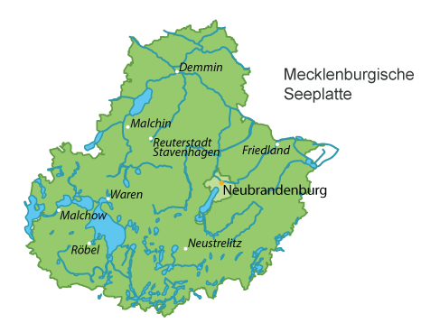
| Locations in the District MECKLENBURGISCHE SEENPLATTE (Source: Wikipedia) |
||||||||||||


| The following Municipal Register contains all places of the "Geschichtlichen Orts-Verzeichnisses" (GOV) of CompGen in MECKLENBURGISCHE SEENPLATTE. By activating the individual buttons in the four columns >Topo<, >SLUB<, >GOV< and >Meyers<, the geographical location of a place can be called up on a map from the geographical OpenTopoMap and Kartenforum or the place descriptions in the GOV-Ortsverzeichnis and Meyers Gazetteer. | ||||||||||||||||||||||||||
| A | B | C | D | E | F | G | H | I | J | K | L | M | N | O | P | Q | R | S | T | U | V | W | X | Y | Z | |
| Community | District | Location Type | GOV | Earth | Meyers | Parts of a Community | Type | Coordinates | Topo | WikiM | SLUB | GOV |
| Alt Rehse | Mecklenburgische Seenplatte | Community |  |
 |
 |
Neu-Wustrow | Residential Area | 53.4761 N 013.1433 E |  |
 |
 |
|
| Jagdhaus | Residential Area | 53.4856 N 013.1603 E | |
|
|
|
Alt Rehse | District | 53.4981 N 013.1627 E | |
|
|
|
Wustrow | District | 53.4783 N 013.1564 E | |
|
|
|
| Alt Schwerin | Mecklenburgische Seenplatte | Community | |
|
|
Alt Schwerin Zeltplatz | Place | 53.5228 N 012.3183 E | |
|
|
|
| Ortkrug | District | 53.5675 N 012.3189 E | |
|
|
|
Glash�tte | District | 53.5308 N 012.3119 E | |
|
|
|
Wendorf | District | 53.5003 N 012.3350 E | |
|
|
|
Werder | Residential Area | 53.4917 N 012.3244 E | |
|
|
|
J�rgenshof | District | 53.4983 N 012.3531 E | |
|
|
|
Alt Schwerin | District | 53.5122 N 012.3514 E | |
|
|
|
M�nchbusch | District | 53.5344 N 012.3319 E | |
|
|
|
| Alt S�hrkow | Mecklenburgische Seenplatte | Community | |
|
|
Hagensruhm | District | 53.7939 N 012.7081 E | |
|
|
|
| Altenhagen | Mecklenburgische Seenplatte | Community | |
|
|
Philippshof | District | 53.7733 N 013.1258 E | |
|
|
|
| Neuenhagen | District | 53.7461 N 013.1117 E | |
|
|
|
Altenhagen | Village | 53.7613 N 013.1047 E | |
|
|
|
| Altenhof | Mecklenburgische Seenplatte | Community | |
|
|
Darze | District | 53.3600 N 012.3814 E | |
|
|
|
| Ausbau | Residential Area | 53.3494 N 012.3406 E | |
|
|
|
||||||
| Ankershagen | Mecklenburgische Seenplatte | Community | |
|
|
Ankershagen | District | 53.4815 N 012.9626 E | |
|
|
|
| Friedrichsfelde | District | 53.4861 N 012.9511 E | |
|
|
|
Rumpelshagen | Place | 53.5000 N 012.9700 E | |
|
|
|
Bornhof | District | 53.4778 N 012.9106 E | |
|
|
|
Rumpshagen | District | 53.5072 N 012.9606 E | |
|
|
|
Ulrichshof | Residential Area | 53.4647 N 012.9192 E | |
|
|
|
| Community | District | Location Type | GOV | Earth | Meyers | Parts of a Community | Type | Coordinates | Topo | WikiM | SLUB | GOV |
| Bartow | Mecklenburgische Seenplatte | Community | |
|
|
Gro� Below | District | 53.8136 N 013.3136 E | |
|
|
|
| Bartow Pfalz | Residential Area | 53.8153 N 013.3703 E | |
|
|
|
||||||
| Basedow | Mecklenburgische Seenplatte | Community | |
|
|
Neu Basedow | District | 53.6608 N 012.6600 E | |
|
|
|
| Seedorf Zeltplatz | Place | 53.6880 N 012.6477 E | |
|
|
|
Teerofen Basedow | District | 53.6706 N 012.7025 E | |
|
|
|
Neuh�user | District | 53.6703 N 012.6431 E | |
|
|
|
Seedorf | District | 53.6881 N 012.6492 E | |
|
|
|
Basedow | District | 53.6972 N 012.6825 E | |
|
|
|
St�ckersoll | District | 53.6839 N 012.6872 E | |
|
|
|
Immensoll | Residential Area | 53.6869 N 012.7128 E | |
|
|
|
Christinenhof | District | 53.6478 N 012.7378 E | |
|
|
|
Gessin | District | 53.6981 N 012.7133 E | |
|
|
|
Basedow H�he | District | 53.7136 N 012.6922 E | |
|
|
|
| Beggerow | Mecklenburgische Seenplatte | Community | |
|
|
Gatschow | District | 53.8364 N 013.0703 E | |
|
|
|
| Glendelin | District | 53.8492 N 013.0464 E | |
|
|
|
Leistenower Papierm�hle | Residential Area | 53.8539 N 013.0758 E | |
|
|
|
Johannenh�he | District | 53.8175 N 013.0517 E | |
|
|
|
Kaslin | District | 53.8039 N 013.0419 E | |
|
|
|
Buschm�hl | District | 53.8522 N 013.0675 E | |
|
|
|
| Blankenhof | Mecklenburgische Seenplatte | Community | |
|
|
Chemnitz | District | 53.5819 N 013.1528 E | |
|
|
|
| Blankenhof | District | 53.5775 N 013.1314 E | |
|
|
|
Gevezin | District | 53.5650 N 013.1119 E | |
|
|
|
| Blankensee | Mecklenburgische Seenplatte | Community | |
|
|
Hasenhof | Residential Area | 53.4233 N 013.2681 E | |
|
|
|
| Zapelshof | Residential Area | 53.4027 N 013.2677 E | |
|
|
|
Wanzka M�hle | Residential Area | 53.4231 N 013.1881 E | |
|
|
|
R�dlin | District | 53.3944 N 013.2311 E | |
|
|
|
Tannenhof | District | 53.3917 N 013.2847 E | |
|
|
|
Tiedtshof | Residential Area | 53.4308 N 013.2658 E | |
|
|
|
Gro� Sch�nfeld | District | 53.3831 N 013.2611 E | |
|
|
|
R�dlin Ausbau | Residential Area | 53.3781 N 013.2228 E | |
|
|
|
Blankensee | District | 53.4163 N 013.2596 E | |
|
|
|
Friedrichsfelde | District | 53.4004 N 013.2891 E | |
|
|
|
Hoffelde | District | 53.3774 N 013.2838 E | |
|
|
|
Neuhof | District | 53.4242 N 013.1995 E | |
|
|
|
Wanzka | District | 53.4069 N 013.2301 E | |
|
|
|
Watzkendorf | District | 53.3921 N 013.3120 E | |
|
|
|
Rollenhagen | District | 53.4055 N 013.2002 E | |
|
|
|
| Blumenholz | Mecklenburgische Seenplatte | Community | |
|
|
Ziegelei | Residential Area | 53.4250 N 013.1097 E | |
|
|
|
| Ehrenhof | District | 53.4320 N 013.1529 E | |
|
|
|
Rodenskrug | Residential Area | 53.4261 N 013.1703 E | |
|
|
|
Pulverm�hle | Residential Area | 53.4431 N 013.1872 E | |
|
|
|
Nonnenm�hle | Residential Area | 53.4544 N 013.1858 E | |
|
|
|
Friedrichshof | District | 53.4211 N 013.1475 E | |
|
|
|
F�rsterei Zachow | Residential Area | 53.4375 N 013.1900 E | |
|
|
|
Blumenholz Nebendorf | District | 53.4114 N 013.1356 E | |
|
|
|
Wendfeld | District | 53.4286 N 013.1263 E | |
|
|
|
Wilhelminenhof | Residential Area | 53.3904 N 013.1415 E | |
|
|
|
Blumenhagen | District | 53.4006 N 013.1275 E | |
|
|
|
Usadel | District | 53.4428 N 013.1791 E | |
|
|
|
Carlshof | Residential Area | 53.4075 N 013.0867 E | |
|
|
|
Weisdin | Village | 53.4008 N 013.1085 E | |
|
|
|
| Bollewick | Mecklenburgische Seenplatte | Community | |
|
|
Spitzkuhn | District | 53.3406 N 012.6083 E | |
|
|
|
| Wildkuhl | District | 53.3267 N 012.5372 E | |
|
|
|
Bollewick | District | 53.3582 N 012.5794 E | |
|
|
|
N�tebow | Residential Area | 53.3622 N 012.5794 E | |
|
|
|
Kambs | District | 53.3175 N 012.5656 E | |
|
|
|
| Borrentin | Mecklenburgische Seenplatte | Community | |
|
|
Gnevezow | District | 53.7908 N 012.9634 E | |
|
|
|
| Borrentin | District | 53.8090 N 012.9677 E | |
|
|
|
Moltzahn | District | 53.7756 N 012.9644 E | |
|
|
|
Wolkwitz | District | 53.7817 N 012.9294 E | |
|
|
|
Schwichtenberg | District | 53.8081 N 012.9989 E | |
|
|
|
Metschow | District | 53.8316 N 012.9708 E | |
|
|
|
Pentz | District | 53.8303 N 012.9950 E | |
|
|
|
Lindenhof | District | 53.8508 N 013.0006 E | |
|
|
|
| Bredenfelde | Mecklenburgische Seenplatte | Community | |
|
|
Neu Bredenfelde | Residential Area | 53.6033 N 012.9286 E | |
|
|
|
| Bredenfelde Ausbau | Residential Area | 53.6111 N 012.9592 E | |
|
|
|
||||||
| Breesen | Mecklenburgische Seenplatte | Community | |
|
|
Kal�bbe | District | 53.6200 N 013.1917 E | |
|
|
|
| Neuhof | Residential Area | 53.6094 N 013.1839 E | |
|
|
|
Pinnow | District | 53.6097 N 013.1418 E | |
|
|
|
Breesen | District | 53.6297 N 013.1633 E | |
|
|
|
| Breest | Mecklenburgische Seenplatte | Community | |
|
|
Klempenow | District | 53.7931 N 013.3119 E | |
|
|
|
| Bittersberg | District | 53.7758 N 013.3242 E | |
|
|
|
||||||
| Briggow | Mecklenburgische Seenplatte | Community | |
|
|
S�lten | District | 53.6311 N 012.9475 E | |
|
|
|
| S�lten Hof | District | 53.6386 N 012.9600 E | |
|
|
|
Briggow | District | 53.6211 N 012.9861 E | |
|
|
|
Briggow Abbaue | Residential Area | 53.6375 N 012.9931 E | |
|
|
|
| Brunn | Mecklenburgische Seenplatte | Community | |
|
|
Birkhof | Residential Area | 53.6825 N 013.4564 E | |
|
|
|
| Birkfeld | Residential Area | 53.6444 N 013.3933 E | |
|
|
|
Ganzkow | District | 53.6622 N 013.3347 E | |
|
|
|
Brunn | District | 53.6703 N 013.3717 E | |
|
|
|
Roggenhagen | District | 53.6606 N 013.4136 E | |
|
|
|
Dahlen | District | 53.6853 N 013.4286 E | |
|
|
|
Neuhof | Deserted Settlement | 53.6816 N 013.3939 E | |
|
|
|
Siedlung Dahlen | Residential Area | 53.6864 N 013.4011 E | |
|
|
|
| Burow | Mecklenburgische Seenplatte | Community | |
|
|
Ausbau | Residential Area | 53.7717 N 013.2997 E | |
|
|
|
| Weltzin | District | 53.7505 N 013.2920 E | |
|
|
|
M�hlenhagen | District | 53.7325 N 013.2747 E | |
|
|
|
Friedenthal | Residential Area | 53.7342 N 013.2778 E | |
|
|
|
| B�tow | Mecklenburgische Seenplatte | Community | |
|
|
Karchow | Residential Area | 53.3492 N 012.5214 E | |
|
|
|
| Carlshof | Deserted Settlement | 53.3653 N 012.5313 E | |
|
|
|
Erlenkamp | District | 53.3436 N 012.5350 E | |
|
|
|
Dambeck | District | 53.3611 N 012.5008 E | |
|
|
|
Wackstow | District | 53.3604 N 012.5521 E | |
|
|
|
| Community | District | Location Type | GOV | Earth | Meyers | Parts of a Community | Type | Coordinates | Topo | WikiM | SLUB | GOV |
| Cammin | Mecklenburgische Seenplatte | Community | |
|
|
Cammin | District | 53.4386 N 013.3006 E | |
|
|
|
| Riepke | District | 53.4522 N 013.3211 E | |
|
|
|
Godenswege | District | 53.4569 N 013.2878 E | |
|
|
|
| Carpin | Mecklenburgische Seenplatte | Community | |
|
|
Bergfeld | District | 53.3530 N 013.2801 E | |
|
|
|
| Oberzinow | Residential Area | 53.3592 N 013.1561 E | |
|
|
|
Dianenhof | Residential Area | 53.3547 N 013.2286 E | |
|
|
|
Carpin | District | 53.3564 N 013.2425 E | |
|
|
|
Goldenbaumer M�hle | District | 53.3169 N 013.2578 E | |
|
|
|
Thurow | District | 53.3770 N 013.1811 E | |
|
|
|
Ochsenkrug | Residential Area | 53.3614 N 013.1467 E | |
|
|
|
Heckenhaus Steinm�hle | Residential Area | 53.3386 N 013.2681 E | |
|
|
|
Posten 77 | Residential Area | 53.3856 N 013.1725 E | |
|
|
|
Goldenbaum | District | 53.3248 N 013.2424 E | |
|
|
|
Schulzenhof | Residential Area | 53.3814 N 013.1742 E | |
|
|
|
Georgenhof | District | 53.3671 N 013.2412 E | |
|
|
|
Serrahn | District | 53.3447 N 013.2019 E | |
|
|
|
Heckenhaus | Residential Area | 53.3672 N 013.1925 E | |
|
|
|
Zinow | District | 53.3627 N 013.1713 E | |
|
|
|
Steinm�hle | Residential Area | 53.3292 N 013.2717 E | |
|
|
|
Teerofen | Residential Area | 53.3733 N 013.1689 E | |
|
|
|
Willertsm�hle | Deserted Settlement | 53.3293 N 013.2166 E | |
|
|
|
| C�lpin | Mecklenburgische Seenplatte | Community | |
|
|
C�lpin | District | 53.5217 N 013.4325 E | |
|
|
|
| F�rsterei | Residential Area | 53.5197 N 013.4764 E | |
|
|
|
Hochkamp | District | 53.5417 N 013.4522 E | |
|
|
|
| Community | District | Location Type | GOV | Earth | Meyers | Parts of a Community | Type | Coordinates | Topo | WikiM | SLUB | GOV |
| Dargun | Mecklenburgische Seenplatte | Town | |
|
|
Leviner Werder | Residential Area | 53.8819 N 012.8861 E | |
|
|
|
| Pisede | Residential Area | 53.9144 N 012.7867 E | |
|
|
|
Ausbau | Residential Area | 53.8842 N 012.8497 E | |
|
|
|
An den Lehnenh�fer Tannen | Residential Area | 53.9111 N 012.8569 E | |
|
|
|
Am Strand | Residential Area | 53.8953 N 012.8483 E | |
|
|
|
Neu Darbein | Residential Area | 53.9342 N 012.8203 E | |
|
|
|
Hof Uhlenkrug | Residential Area | 53.9553 N 012.7967 E | |
|
|
|
K�tzerhof | Residential Area | 53.8594 N 012.8503 E | |
|
|
|
Karlshof | Residential Area | 53.9600 N 012.8403 E | |
|
|
|
Neubauhof | Residential Area | 53.9086 N 012.8756 E | |
|
|
|
Ausbau Brudersdorf | Residential Area | 53.9383 N 012.8667 E | |
|
|
|
Remershof | Residential Area | 53.8997 N 012.9194 E | |
|
|
|
Glasow | Residential Area | 53.9067 N 012.7994 E | |
|
|
|
Schwarzenhof | Residential Area | 53.8653 N 012.8000 E | |
|
|
|
D�rgelin | Residential Area | 53.8914 N 012.7967 E | |
|
|
|
Lehnenhof | Residential Area | 53.9261 N 012.8431 E | |
|
|
|
Levin | Residential Area | 53.8999 N 012.8914 E | |
|
|
|
Stubbendorf-Polchow | Residential Area | 53.9569 N 012.8225 E | |
|
|
|
Klein Methling | Residential Area | 53.9700 N 012.8131 E | |
|
|
|
Aalbude | Residential Area | 53.8483 N 012.8875 E | |
|
|
|
Stubbendorf | District | 53.9497 N 012.8147 E | |
|
|
|
Altbauhof | Residential Area | 53.8900 N 012.8583 E | |
|
|
|
Barlin | Residential Area | 53.9219 N 012.8847 E | |
|
|
|
Darbein | Residential Area | 53.9372 N 012.8414 E | |
|
|
|
Zarnekow | District | 53.9027 N 012.8998 E | |
|
|
|
Gro� Methling | Residential Area | 53.9636 N 012.8314 E | |
|
|
|
Brudersdorf | District | 53.9535 N 012.8790 E | |
|
|
|
Wagun | District | 53.8692 N 012.8189 E | |
|
|
|
| Datzetal | Mecklenburgische Seenplatte | Community | |
|
|
Sadelkow | District | 53.6049 N 013.4535 E | |
|
|
|
| Pleetz | District | 53.6581 N 013.4797 E | |
|
|
|
Tannensch�ferei | Deserted Settlement | 53.6594 N 013.4627 E | |
|
|
|
Bassow | District | 53.6125 N 013.4444 E | |
|
|
|
Roga | District | 53.6431 N 013.4575 E | |
|
|
|
Sadelkow | District | |
Sadelkow Siedlung | District | 53.5989 N 013.4700 E | |
|
|
|
Roga Ausbau | Residential Area | 53.6283 N 013.4569 E | |
|
|
|
Salow | District | 53.6778 N 013.4922 E | |
|
|
|
| Demmin | Mecklenburgische Seenplatte | Town | |
|
|
Stadtrandsiedlung | Residential Area | 53.9053 N 013.0058 E | |
|
|
|
| Devener Hof | Residential Area | 53.9019 N 012.9956 E | |
|
|
|
Devener Holz | Residential Area | 53.8950 N 013.0072 E | |
|
|
|
Eichholz | Residential Area | 53.9122 N 013.0056 E | |
|
|
|
Erdmannsh�he | Residential Area | 53.9258 N 013.0136 E | |
|
|
|
J�gerhof | Residential Area | 53.9203 N 013.0667 E | |
|
|
|
Karlshof | Residential Area | 53.9194 N 013.0833 E | |
|
|
|
Seedorf | District | 53.9553 N 013.0144 E | |
|
|
|
Neu Vorwerk | Residential Area | 53.8858 N 013.0086 E | |
|
|
|
Adolfshof | Residential Area | 53.9294 N 013.0256 E | |
|
|
|
Siedlung am Devener Holz | Residential Area | 53.8956 N 013.0183 E | |
|
|
|
Stuterhof | Residential Area | 53.9039 N 013.0231 E | |
|
|
|
Wendeforst | Residential Area | 53.9203 N 012.9658 E | |
|
|
|
Meyenkrebs | Residential Area | 53.9183 N 013.0275 E | |
|
|
|
Klenz | Residential Area | 53.8772 N 012.9950 E | |
|
|
|
Randow | District | 53.9431 N 013.0633 E | |
|
|
|
Wotenick | District | 53.9387 N 012.9875 E | |
|
|
|
Wotenick Ausbau | Residential Area | 53.9331 N 013.0078 E | |
|
|
|
Woldeforst | District | 53.9597 N 013.0383 E | |
|
|
|
Neubauhof | Residential Area | 53.9120 N 013.0860 E | |
|
|
|
Waldberg | District | 53.9283 N 013.0514 E | |
|
|
|
Sandbergstannen | Residential Area | 53.8990 N 013.0630 E | |
|
|
|
Lindenfelde | District | 53.8744 N 013.0192 E | |
|
|
|
Gustavshof | Residential Area | 53.9310 N 013.0320 E | |
|
|
|
Kuhfeld | Residential Area | 53.9190 N 013.0740 E | |
|
|
|
Siebeneichen | Residential Area | 53.8961 N 013.1036 E | |
|
|
|
Dr�nnewitz | District | 53.9128 N 012.9786 E | |
|
|
|
Vorwerk | Residential Area | 53.8922 N 013.0397 E | |
|
|
|
| Duckow | Mecklenburgische Seenplatte | Community | |
|
|
Pinnow | Village | 53.6738 N 012.8137 E | |
|
|
|
| Community | District | Location Type | GOV | Earth | Meyers | Parts of a Community | Type | Coordinates | Topo | WikiM | SLUB | GOV |
| Eichhorst | Mecklenburgische Seenplatte | Community | |
|
|
Meierei | Residential Area | 53.6242 N 013.5406 E | |
|
|
|
| Liepen | District | 53.5747 N 013.4772 E | |
|
|
|
Jatzke | District | 53.6041 N 013.5328 E | |
|
|
|
Rutheim | Deserted Settlement | 53.5752 N 013.4959 E | |
|
|
|
Ausbau Genzkower Stra�e | Residential Area | 53.6156 N 013.5164 E | |
|
|
|
Kirchhof Eichhorst | Cemetery | 53.5937 N 013.4954 E | |
|
|
|
Eichhorst | District | 53.5947 N 013.4958 E | |
|
|
|
| Community | District | Location Type | GOV | Earth | Meyers | Parts of a Community | Type | Coordinates | Topo | WikiM | SLUB | GOV |
| Faulenrost | Mecklenburgische Seenplatte | Community | |
|
|
Rittermannshagen | District | 53.6236 N 012.7619 E | |
|
|
|
| Faulenrost Abbau | Residential Area | 53.6567 N 012.7839 E | |
|
|
|
Rittermannshagen Hof | Residential Area | 53.6333 N 012.7539 E | |
|
|
|
Rittermannshagen Ausbau | Residential Area | 53.6172 N 012.7506 E | |
|
|
|
Demzin | District | 53.6669 N 012.7878 E | |
|
|
|
Liepen | District | 53.6692 N 012.7367 E | |
|
|
|
Schwabendorf | District | 53.6278 N 012.7936 E | |
|
|
|
Faulenrost | District | 53.6383 N 012.7861 E | |
|
|
|
Hungerstorf | District | 53.6053 N 012.8219 E | |
|
|
|
| Feldberger Seenlandschaft | Mecklenburgische Seenplatte | Community | |
|
|
Rothe Haus | Residential Area | 53.3642 N 013.5047 E | |
|
|
|
| Tornowhof | District | 53.3540 N 013.4924 E | |
|
|
|
Weitendorf | District | 53.3568 N 013.3912 E | |
|
|
|
Hasself�rde | District | 53.2836 N 013.3025 E | |
|
|
|
Forsthaus | Residential Area | 53.3631 N 013.4944 E | |
|
|
|
Carwitz | District | 53.3022 N 013.4398 E | |
|
|
|
Lichtenberg | District | 53.3803 N 013.4992 E | |
|
|
|
Wrechen | District | 53.3753 N 013.5401 E | |
|
|
|
Sch�nhof | Residential Area | 53.3614 N 013.5161 E | |
|
|
|
Cantnitz | District | 53.3813 N 013.3867 E | |
|
|
|
Neugarten | District | 53.4013 N 013.5040 E | |
|
|
|
Kr�seliner M�hle | District | 53.2675 N 013.4156 E | |
|
|
|
Tackmannshof | Farmstead | 53.2436 N 013.3925 E | |
|
|
|
Lych | Residential Area | 53.2486 N 013.3972 E | |
|
|
|
Hohenwippel | District | 53.3706 N 013.3450 E | |
|
|
|
Rosenhof | District | 53.2990 N 013.4194 E | |
|
|
|
Gr�nder Ausbau | Residential Area | 53.3433 N 013.4647 E | |
|
|
|
Ausbau Offen | Residential Area | 53.3133 N 013.4203 E | |
|
|
|
Feldberg | District | 53.3354 N 013.4388 E | |
|
|
|
Feldberger H�tte | Residential Area | 53.3508 N 013.4439 E | |
|
|
|
Gnewitz | District | 53.2861 N 013.2794 E | |
|
|
|
Krumbeck | District | 53.4025 N 013.4472 E | |
|
|
|
Hochfeld | District | 53.2842 N 013.3583 E | |
|
|
|
Dolgen Siedlung | District | 53.3511 N 013.3364 E | |
|
|
|
Labee | District | 53.3017 N 013.3191 E | |
|
|
|
F�rstenhagen | District | 53.3373 N 013.5037 E | |
|
|
|
L�ven | District | 53.3058 N 013.3868 E | |
|
|
|
L�ttenhagen | District | 53.3383 N 013.3842 E | |
|
|
|
Mechow | District | 53.2678 N 013.3839 E | |
|
|
|
Schlicht | District | 53.3680 N 013.4433 E | |
|
|
|
Sandkrug | Deserted Settlement | 53.2837 N 013.3232 E | |
|
|
|
Terra Nova | Deserted Settlement | 53.3961 N 013.4021 E | |
|
|
|
Koldenhof | District | 53.3315 N 013.3419 E | |
|
|
|
Gr�pkenteich | District | 53.3068 N 013.3389 E | |
|
|
|
Wittenhagen | District | 53.3397 N 013.4694 E | |
|
|
|
Triepkendorf | District | 53.2901 N 013.3376 E | |
|
|
|
Neuhof | District | 53.3225 N 013.4125 E | |
|
|
|
S�gewerk Koldenhof | District | 53.3203 N 013.3425 E | |
|
|
|
Dolgen | District | 53.3536 N 013.3544 E | |
|
|
|
K�llershof | District | 53.3675 N 013.3583 E | |
|
|
|
Waldsee | District | 53.3003 N 013.2934 E | |
|
|
|
Conow | District | 53.3142 N 013.4893 E | |
|
|
|
Hullerbusch | Residential Area | 53.3219 N 013.4442 E | |
|
|
|
| Fincken | Mecklenburgische Seenplatte | Community | |
|
|
Jaebetz | District | 53.3202 N 012.3664 E | |
|
|
|
| Marienhof | District | 53.3225 N 012.3422 E | |
|
|
|
Kn�ppeldamm Ausbau | Residential Area | 53.3278 N 012.4028 E | |
|
|
|
Kaeselin | District | 53.3622 N 012.4314 E | |
|
|
|
Fincken Ausbau | Residential Area | 53.3375 N 012.4589 E | |
|
|
|
Kn�ppeldamm | District | 53.3386 N 012.4031 E | |
|
|
|
Dammwolde | District | 53.3292 N 012.3600 E | |
|
|
|
Fichtental | Residential Area | 53.3219 N 012.3819 E | |
|
|
|
| Friedland | Mecklenburgische Seenplatte | Town | |
|
|
Carolinenhof | Deserted Settlement | 53.6395 N 013.5213 E | |
|
|
|
| Schwanbeck | District | 53.7295 N 013.4429 E | |
|
|
|
Kavel | Deserted Settlement | 53.6964 N 013.5705 E | |
|
|
|
Ziegelei Bresewitz | Residential Area | 53.7092 N 013.5075 E | |
|
|
|
Mohrmannshof | Residential Area | 53.6500 N 013.5247 E | |
|
|
|
Brohm | District | 53.6076 N 013.5954 E | |
|
|
|
Hohenstein | District | 53.6272 N 013.5889 E | |
|
|
|
Ramelow | District | 53.7386 N 013.4814 E | |
|
|
|
Bauersheim | Residential Area | 53.6803 N 013.5744 E | |
|
|
|
Heinrichsh�h | Residential Area | 53.6736 N 013.6014 E | |
|
|
|
G�nthersfelde | Residential Area | 53.6850 N 013.5478 E | |
|
|
|
Friedberg | Residential Area | 53.5950 N 013.6086 E | |
|
|
|
Cosa | District | 53.6086 N 013.6033 E | |
|
|
|
Bresewitz | Residential Area | 53.7008 N 013.5211 E | |
|
|
|
Meierei | Residential Area | 53.7222 N 013.5117 E | |
|
|
|
Brille | Residential Area | 53.6953 N 013.5236 E | |
|
|
|
Heinrichswalde | District | 53.6117 N 013.5562 E | |
|
|
|
| F�nfseen | Mecklenburgische Seenplatte | Community | |
|
|
Adamshoffnung | District | 53.4469 N 012.3633 E | |
|
|
|
| Lenz-S�d | District | 53.4672 N 012.3483 E | |
|
|
|
Satow | District | 53.4081 N 012.3794 E | |
|
|
|
Kogel | District | 53.4081 N 012.4169 E | |
|
|
|
Petersdorf | District | 53.4589 N 012.3772 E | |
|
|
|
Gr�ssow | District | 53.4450 N 012.4281 E | |
|
|
|
Bruchm�hle | Residential Area | 53.4406 N 012.3911 E | |
|
|
|
Satow H�tte | District | 53.4233 N 012.3875 E | |
|
|
|
Rogeez | District | 53.3900 N 012.3925 E | |
|
|
|
Biestorf | District | 53.4681 N 012.3678 E | |
|
|
|
Lenz | District | 53.4703 N 012.3508 E | |
|
|
|
| Community | District | Location Type | GOV | Earth | Meyers | Parts of a Community | Type | Coordinates | Topo | WikiM | SLUB | GOV |
| Galenbeck | Mecklenburgische Seenplatte | Community | |
|
|
Rohrkrug | District | 53.6028 N 013.7194 E | |
|
|
|
| Annenhof | Deserted Settlement | 53.6005 N 013.7063 E | |
|
|
|
Galenbeck | District | 53.6203 N 013.7056 E | |
|
|
|
Schwichtenberg | District | 53.6850 N 013.7058 E | |
|
|
|
Friedrichshof | District | 53.6175 N 013.6333 E | |
|
|
|
Ausbau | Residential Area | 53.6458 N 013.5842 E | |
|
|
|
Alte M�hle | Residential Area | 53.6306 N 013.6344 E | |
|
|
|
Meierei | Residential Area | 53.6292 N 013.6094 E | |
|
|
|
Mecklenburger Hof | Residential Area | 53.6731 N 013.6256 E | |
|
|
|
L�bbersdorf | District | 53.6476 N 013.6041 E | |
|
|
|
Uhlenhorst | Deserted Settlement | 53.6796 N 013.7279 E | |
|
|
|
Klockow | District | 53.6714 N 013.6803 E | |
|
|
|
Sandhagen | District | 53.6811 N 013.6361 E | |
|
|
|
Kotelow | District | 53.6506 N 013.6556 E | |
|
|
|
Wittenborn | District | 53.6128 N 013.6625 E | |
|
|
|
Johannisberg | Residential Area | 53.6017 N 013.6619 E | |
|
|
|
| Gielow | Mecklenburgische Seenplatte | Community | |
|
|
Gielow | District | 53.6986 N 012.7436 E | |
|
|
|
| Peenh�user | District | 53.6992 N 012.7711 E | |
|
|
|
Gielow Ausbau | Residential Area | 53.6828 N 012.7589 E | |
|
|
|
Gielower M�hle | Residential Area | 53.7106 N 012.7664 E | |
|
|
|
Hinrichsfelde | District | 53.6753 N 012.7517 E | |
|
|
|
Alte Ziegelei | Residential Area | 53.6417 N 012.7319 E | |
|
|
|
| Gnevkow | Mecklenburgische Seenplatte | Community | |
|
|
Marienh�he | District | 53.7806 N 013.1806 E | |
|
|
|
| Letzin | District | 53.7822 N 013.2031 E | |
|
|
|
Pr�tzen | District | 53.7742 N 013.1614 E | |
|
|
|
Letzin-Siedlung | District | 53.7894 N 013.2283 E | |
|
|
|
| Godendorf | Mecklenburgische Seenplatte | Community | |
|
|
Godendorfer Papierm�hle | District | 53.2525 N 013.1314 E | |
|
|
|
| Bahnhof | Residential Area | 53.2456 N 013.1039 E | |
|
|
|
Chausseehaus | Residential Area | 53.2433 N 013.1111 E | |
|
|
|
S�gewerk | Residential Area | 53.2472 N 013.0869 E | |
|
|
|
F�rsterei | Residential Area | 53.2417 N 013.1150 E | |
|
|
|
D�sterf�rde | District | 53.2520 N 013.1142 E | |
|
|
|
Godendorfer Schneidem�hle | Residential Area | 53.2439 N 013.1283 E | |
|
|
|
Godendorfer Teerofen | District | 53.2492 N 013.1308 E | |
|
|
|
Godendorf | District | 53.2572 N 013.1539 E | |
|
|
|
| G�hren-Lebbin | Mecklenburgische Seenplatte | Community | |
|
|
Wendhof | District | 53.4806 N 012.5486 E | |
|
|
|
| Lebbin | District | 53.4792 N 012.5094 E | |
|
|
|
Poppentin | District | 53.4608 N 012.5531 E | |
|
|
|
Alt Poppentin | Residential Area | 53.4578 N 012.5369 E | |
|
|
|
Kirch Poppentin | Residential Area | 53.4664 N 012.5356 E | |
|
|
|
Roez | District | 53.4542 N 012.5189 E | |
|
|
|
Unterg�hren | District | 53.4919 N 012.4897 E | |
|
|
|
Unterg�hren Zeltplatz | Place | |
| Golchen | Mecklenburgische Seenplatte | Community | |
|
|
T�ckhude | District | 53.8178 N 013.2658 E | |
|
|
|
| Ludwigsh�he | District | 53.7994 N 013.2675 E | |
|
|
|
Rohrsoll | District | 53.7858 N 013.2956 E | |
|
|
|
| Gotthun | Mecklenburgische Seenplatte | Community | |
|
|
Gotthun Zeltplatz | Place | 53.4275 N 012.6132 E | |
|
|
|
| Schamper M�hle | Residential Area | 53.4136 N 012.5756 E | |
|
|
|
||||||
| Grabow-Below | Mecklenburgische Seenplatte | Community | |
|
|
Grabow | District | 53.2789 N 012.4408 E | |
|
|
|
| Below | District | 53.2596 N 012.4634 E | |
|
|
|
||||||
| Grabowh�fe | Mecklenburgische Seenplatte | Community | |
|
|
Alte Ziegelei | Residential Area | 53.5800 N 012.5731 E | |
|
|
|
| Louisenfeld | District | 53.5914 N 012.5831 E | |
|
|
|
Grabowh�fe | District | 53.5697 N 012.5981 E | |
|
|
|
Sophienhof | District | 53.5961 N 012.5536 E | |
|
|
|
Baumgarten | District | 53.5789 N 012.6325 E | |
|
|
|
Panschenhagen | District | 53.5936 N 012.6414 E | |
|
|
|
Sommerstorf | District | 53.5889 N 012.5964 E | |
|
|
|
Kr�henberg | Residential Area | 53.5906 N 012.6153 E | |
|
|
|
Sommerstorf Ausbau | Residential Area | 53.6008 N 012.6008 E | |
|
|
|
| Grammentin | Mecklenburgische Seenplatte | Community | |
|
|
Wolfskuhle | Residential Area | 53.7572 N 012.9153 E | |
|
|
|
| Altes Forsthaus | Residential Area | 53.7619 N 012.9208 E | |
|
|
|
||||||
| Grapzow | Mecklenburgische Seenplatte | Community | |
|
|
Kessin | District | 53.7300 N 013.3075 E | |
|
|
|
| Grischow | Mecklenburgische Seenplatte | Community | |
|
|
Oberstriet | Residential Area | 53.6928 N 013.3158 E | |
|
|
|
| Unterstriet | Residential Area | 53.6819 N 013.3242 E | |
|
|
|
||||||
| Gro� Gievitz | Mecklenburgische Seenplatte | Community | |
|
|
Ziegelei | Residential Area | 53.6006 N 012.7875 E | |
|
|
|
| Klein Gievitz | District | 53.5733 N 012.7586 E | |
|
|
|
Carlsruh | District | 53.5722 N 012.7342 E | |
|
|
|
Minenhof | District | 53.5619 N 012.8017 E | |
|
|
|
| Gro� Miltzow | Mecklenburgische Seenplatte | Community | |
|
|
Klein Miltzow | Deserted Settlement | 53.5229 N 013.6063 E | |
|
|
|
| Badresch | District | 53.5456 N 013.6153 E | |
|
|
|
Ulrichshof | District | 53.5331 N 013.5549 E | |
|
|
|
Holzendorf Ausbau | Residential Area | 53.5203 N 013.5703 E | |
|
|
|
Schills Versteck | Deserted Settlement | 53.5206 N 013.6639 E | |
|
|
|
Forsthaus | Residential Area | 53.5183 N 013.5972 E | |
|
|
|
Miltzow-Holzendorf | District | 53.5352 N 013.5766 E | |
|
|
|
Golm | District | 53.5643 N 013.5640 E | |
|
|
|
Kreckow | District | 53.5185 N 013.6428 E | |
|
|
|
Klein Daberkow | District | 53.5361 N 013.6550 E | |
|
|
|
Lindow | District | 53.5567 N 013.5939 E | |
|
|
|
| Gro� Nemerow | Mecklenburgische Seenplatte | Community | |
|
|
Bornshof | Residential Area | 53.4758 N 013.2011 E | |
|
|
|
| Zachow | District | 53.4486 N 013.2196 E | |
|
|
|
Stegemannshof | Residential Area | 53.4699 N 013.1907 E | |
|
|
|
Sch�nlage | Residential Area | 53.4689 N 013.1917 E | |
|
|
|
Ahrendshof | Residential Area | 53.4700 N 013.2011 E | |
|
|
|
Bornm�hle | Residential Area | 53.4750 N 013.1972 E | |
|
|
|
Krickow | District | 53.4603 N 013.2006 E | |
|
|
|
Gro� Nemerow | District | 53.4728 N 013.2258 E | |
|
|
|
Klein Nemerow | District | 53.4892 N 013.2153 E | |
|
|
|
Tollenseheim | District | 53.4722 N 013.1919 E | |
|
|
|
| Gro� Plasten | Mecklenburgische Seenplatte | Community | |
|
|
Rundling | Residential Area | 53.5292 N 012.8583 E | |
|
|
|
| Gro� Plasten | District | 53.5458 N 012.8511 E | |
|
|
|
Deven | District | 53.5650 N 012.8514 E | |
|
|
|
Klein Plasten | District | 53.5369 N 012.8461 E | |
|
|
|
| Gro� Teetzleben | Mecklenburgische Seenplatte | Community | |
|
|
Lebbin | District | 53.6186 N 013.2311 E | |
|
|
|
| Kaluberhof | District | 53.6344 N 013.2022 E | |
|
|
|
Klein Teetzleben | District | 53.6517 N 013.2353 E | |
|
|
|
Ulhof | Residential Area | 53.6325 N 013.2353 E | |
|
|
|
Gro� Teetzleben | Village | 53.6463 N 013.2271 E | |
|
|
|
Rottenhof | District | 53.6636 N 013.1997 E | |
|
|
|
| Gr�now | Mecklenburgische Seenplatte | Community | |
|
|
Ollendorf | District | 53.3641 N 013.3085 E | |
|
|
|
| Gr�now | District | 53.3442 N 013.3128 E | |
|
|
|
Forsthaus | Residential Area | 53.3347 N 013.3169 E | |
|
|
|
Vogelheidi | Residential Area | 53.3456 N 013.2983 E | |
|
|
|
| G�ltz | Mecklenburgische Seenplatte | Community | |
|
|
Hermannsh�he | District | 53.7608 N 013.1697 E | |
|
|
|
| G�ltz | Village | 53.7503 N 013.1872 E | |
|
|
|
Seltz | District | 53.7586 N 013.2150 E | |
|
|
|
Seltz-Pflegeheim | Residential Area | 53.7608 N 013.2364 E | |
|
|
|
Goldbacher M�hle | Residential Area | 53.7464 N 013.2328 E | |
|
|
|
| G�lzow | Mecklenburgische Seenplatte | Community | |
|
|
G�lzow | Village | 53.6934 N 012.8540 E | |
|
|
|
| Forsthof | Residential Area | 53.6775 N 012.8475 E | |
|
|
|
||||||
| Community | District | Location Type | GOV | Earth | Meyers | Parts of a Community | Type | Coordinates | Topo | WikiM | SLUB | GOV |
| Helpt | Mecklenburgische Seenplatte | Community | |
|
|
Helpt | District | 53.5058 N 013.5951 E | |
|
|
|
| Ernstfelde | Deserted Settlement | 53.5142 N 013.5339 E | |
|
|
|
Oertzenhof | District | 53.5178 N 013.5731 E | |
|
|
|
Pasenow | District | 53.4994 N 013.5522 E | |
|
|
|
Tollenhof | Deserted Settlement | 53.5008 N 013.5274 E | |
|
|
|
Melkenhof | Deserted Settlement | 53.5136 N 013.5407 E | |
|
|
|
Johannesberg | Residential Area | 53.4947 N 013.5736 E | |
|
|
|
| Hohen Wangelin | Mecklenburgische Seenplatte | Community | |
|
|
Liepen | District | 53.6331 N 012.4308 E | |
|
|
|
| Hohen Wangelin | District | 53.6116 N 012.4255 E | |
|
|
|
Kraaz | Deserted Settlement | 53.5809 N 012.4661 E | |
|
|
|
Wagelin | Place | 53.6000 N 012.4200 E | |
|
|
|
Kniep | District | 53.5942 N 012.4450 E | |
|
|
|
Cramon | District | 53.6083 N 012.4564 E | |
|
|
|
Malkwitz | District | 53.5775 N 012.4419 E | |
|
|
|
| Hohenmocker | Mecklenburgische Seenplatte | Community | |
|
|
Strehlow | District | 53.8269 N 013.1428 E | |
|
|
|
| Tentzerow | District | 53.8181 N 013.1903 E | |
|
|
|
Hohenbr�nzow | District | 53.8148 N 013.1421 E | |
|
|
|
Sternfeld | District | 53.8264 N 013.1644 E | |
|
|
|
Peeselin | District | 53.8047 N 013.1894 E | |
|
|
|
| Hohenzieritz | Mecklenburgische Seenplatte | Community | |
|
|
Sandm�hle | Residential Area | 53.4297 N 013.1011 E | |
|
|
|
| Hohenzieritz | Village | 53.4447 N 013.0996 E | |
|
|
|
Prillwitz | Village | 53.4534 N 013.1369 E | |
|
|
|
Zippelow | District | 53.4608 N 013.1281 E | |
|
|
|
Christenhof | Deserted Settlement | 53.4651 N 013.0964 E | |
|
|
|
| Holldorf | Mecklenburgische Seenplatte | Community | |
|
|
Rowa | District | 53.4869 N 013.2700 E | |
|
|
|
| Wiesenbr�ck | Deserted Settlement | 53.4660 N 013.2456 E | |
|
|
|
Ballwitz | District | 53.4569 N 013.2508 E | |
|
|
|
Holldorf | District | 53.4650 N 013.2711 E | |
|
|
|
Forsthof | Residential Area | 53.4444 N 013.2506 E | |
|
|
|
| Community | District | Location Type | GOV | Earth | Meyers | Parts of a Community | Type | Coordinates | Topo | WikiM | SLUB | GOV |
| Ivenack | Mecklenburgische Seenplatte | Community | |
|
|
Zolkendorf | District | 53.7217 N 013.0092 E | |
|
|
|
| Ivenack | District | 53.7112 N 012.9668 E | |
|
|
|
Markower M�hle | Deserted Settlement | 53.7339 N 013.0308 E | |
|
|
|
Grischow | District | 53.6886 N 013.0092 E | |
|
|
|
Wackerow | District | 53.6769 N 012.9817 E | |
|
|
|
Fahrenholz | District | 53.7447 N 013.0739 E | |
|
|
|
Weitendorf | District | 53.6947 N 012.9903 E | |
|
|
|
Goddin | District | 53.6667 N 013.0247 E | |
|
|
|
Basepohl | District | 53.7247 N 012.9186 E | |
|
|
|
Klockow | District | 53.7011 N 012.9528 E | |
|
|
|
Markow | District | 53.7408 N 013.0186 E | |
|
|
|
| Community | District | Location Type | GOV | Earth | Meyers | Parts of a Community | Type | Coordinates | Topo | WikiM | SLUB | GOV |
| Jabel | Mecklenburgische Seenplatte | Community | |
|
|
Jabel Zeltplatz | Place | |
||||
| Damerow | District | 53.5297 N 012.5503 E | |
|
|
|
Jabel | District | 53.5367 N 012.5444 E | |
|
|
|
Loppin | District | 53.5517 N 012.5164 E | |
|
|
|
| J�rgenstorf | Mecklenburgische Seenplatte | Community | |
|
|
Vo�hagen | District | 53.6497 N 012.8864 E | |
|
|
|
| Gut Rottmannshagen | Estate | 53.6491 N 012.8598 E | |
|
|
|
Waldhaus | Residential Area | 53.6578 N 012.8806 E | |
|
|
|
Rottmannshagen | District | 53.6507 N 012.8588 E | |
|
|
|
Krummsee | District | 53.6508 N 012.9311 E | |
|
|
|
J�rgenstorf | Village | 53.6608 N 012.9044 E | |
|
|
|
Bremsenkrug | Residential Area | 53.6458 N 012.9397 E | |
|
|
|
| Community | District | Location Type | GOV | Earth | Meyers | Parts of a Community | Type | Coordinates | Topo | WikiM | SLUB | GOV |
| Kargow | Mecklenburgische Seenplatte | Community | |
|
|
Federow | District | 53.4831 N 012.7617 E | |
|
|
|
| Priesterb�k | Deserted Settlement | 53.4174 N 012.8500 E | |
|
|
|
Schwarzenhof | District | 53.4636 N 012.7989 E | |
|
|
|
Rehhof | Residential Area | 53.4569 N 012.8150 E | |
|
|
|
Damerow | District | 53.4842 N 012.7417 E | |
|
|
|
Kargow-Unterdorf | District | 53.4981 N 012.7725 E | |
|
|
|
Speck | District | 53.4386 N 012.8403 E | |
|
|
|
Godow | District | 53.5119 N 012.7617 E | |
|
|
|
Kargow | District | 53.5108 N 012.7847 E | |
|
|
|
Charlottenhof | Deserted Settlement | 53.5020 N 012.8216 E | |
|
|
|
| Kentzlin | Mecklenburgische Seenplatte | Community | |
|
|
Neu Kentzlin | District | 53.7650 N 012.9848 E | |
|
|
|
| Alt Kentzlin | District | 53.7550 N 012.9714 E | |
|
|
|
||||||
| Kittendorf | Mecklenburgische Seenplatte | Community | |
|
|
Mittelhof | District | 53.6144 N 012.8839 E | |
|
|
|
| Oevelg�nde | District | 53.6275 N 012.9308 E | |
|
|
|
Bauernreihe | Residential Area | 53.6344 N 012.8875 E | |
|
|
|
Clausdorf | District | 53.6042 N 012.8517 E | |
|
|
|
Kittendorf | Village | 53.6239 N 012.9033 E | |
|
|
|
| Klein Vielen | Mecklenburgische Seenplatte | Community | |
|
|
Brustorf | District | 53.4317 N 013.0475 E | |
|
|
|
| Klein Vielen | District | 53.4534 N 013.0319 E | |
|
|
|
Jennyhof | Deserted Settlement | 53.4647 N 013.0784 E | |
|
|
|
Hartwigsdorf | District | 53.4553 N 012.9963 E | |
|
|
|
Peckatel | District | 53.4469 N 013.0522 E | |
|
|
|
Ausbau | Residential Area | 53.4247 N 013.0414 E | |
|
|
|
Ziegelei | Residential Area | 53.4347 N 013.0522 E | |
|
|
|
Kreutzsee | Residential Area | 53.4489 N 012.9758 E | |
|
|
|
F�rsterei | Residential Area | 53.4244 N 013.0469 E | |
|
|
|
Liepen | District | 53.4331 N 012.9869 E | |
|
|
|
| Kletzin | Mecklenburgische Seenplatte | Community | |
|
|
Pensin | District | 53.9333 N 013.0897 E | |
|
|
|
| Quitzerow | District | 53.9279 N 013.1119 E | |
|
|
|
Kletzin | District | 53.9244 N 013.1558 E | |
|
|
|
�ckeritz | District | 53.9228 N 013.1833 E | |
|
|
|
| Klink | Mecklenburgische Seenplatte | Community | |
|
|
Sembzin | District | 53.4622 N 012.6083 E | |
|
|
|
| Bellevue | Residential Area | 53.5039 N 012.6442 E | |
|
|
|
Eldenburg S�d | District | 53.5058 N 012.6325 E | |
|
|
|
Eldenburg | District | 53.5094 N 012.6356 E | |
|
|
|
Grabenitz | District | 53.4728 N 012.5794 E | |
|
|
|
Klink | District | 53.4781 N 012.6217 E | |
|
|
|
Klink Urlaubersiedlung | Settlement | 53.4884 N 012.6325 E | |
|
|
|
| Klocksin | Mecklenburgische Seenplatte | Community | |
|
|
L�tgendorf | District | |
||||
| Bl�cherhof | District | 53.6164 N 012.5192 E | |
|
|
|
Sapshagen | District | 53.6172 N 012.5642 E | |
|
|
|
Hof L�tgendorf | District | 53.6092 N 012.5222 E | |
|
|
|
Klocksin | District | 53.6364 N 012.5406 E | |
|
|
|
Neuhof | District | 53.6508 N 012.5436 E | |
|
|
|
Neu Klocksin | Residential Area | 53.6397 N 012.5747 E | |
|
|
|
Kirch L�tgendorf | District | 53.6042 N 012.5199 E | |
|
|
|
| Knorrendorf | Mecklenburgische Seenplatte | Community | |
|
|
Karlshof | Deserted Settlement | 53.6414 N 013.0779 E | |
|
|
|
| G�debehn | District | 53.6169 N 013.0897 E | |
|
|
|
Friedrichsruh | District | 53.6281 N 013.1008 E | |
|
|
|
Kastorf | District | 53.6578 N 013.0633 E | |
|
|
|
Siedlung Kleeth | Residential Area | 53.6178 N 013.0586 E | |
|
|
|
Knorrendorf | District | 53.6318 N 013.0669 E | |
|
|
|
Kleeth | District | 53.6136 N 013.0731 E | |
|
|
|
| Kratzeburg | Mecklenburgische Seenplatte | Community | |
|
|
Dalmsdorf | District | 53.4223 N 012.9305 E | |
|
|
|
| Henningsfelde | Residential Area | 53.3972 N 012.9111 E | |
|
|
|
Kratzeburg | District | 53.4292 N 012.9444 E | |
|
|
|
Dambeck | District | 53.4456 N 012.9378 E | |
|
|
|
K�belick | Place | 53.4164 N 012.9414 E | |
|
|
|
Pieverstorf | District | 53.4543 N 012.9563 E | |
|
|
|
Krienke | District | 53.3914 N 012.8761 E | |
|
|
|
Granziner M�hle | Residential Area | 53.4053 N 012.8972 E | |
|
|
|
Granzin | District | 53.4122 N 012.9042 E | |
|
|
|
| Kriesow | Mecklenburgische Seenplatte | Community | |
|
|
T�zen | District | 53.7206 N 013.0378 E | |
|
|
|
| Kriesow | District | 53.7335 N 013.0496 E | |
|
|
|
Borgfeld | District | 53.7158 N 013.0558 E | |
|
|
|
| Kublank | Mecklenburgische Seenplatte | Community | |
|
|
Funkenhof | Residential Area | 53.5556 N 013.4747 E | |
|
|
|
| Friedrichshof | District | 53.5672 N 013.5194 E | |
|
|
|
Dorotheenhof | Deserted Settlement | 53.5459 N 013.5353 E | |
|
|
|
Sandberg | Residential Area | 53.5500 N 013.4936 E | |
|
|
|
Kublank | District | 53.5544 N 013.5064 E | |
|
|
|
| Kuckssee | Mecklenburgische Seenplatte | Community | |
|
|
Krukow | Village | 53.5209 N 013.1297 E | |
|
|
|
| Ausbau | Residential Area | 53.5542 N 013.1058 E | |
|
|
|
Lapitz | Village | 53.5459 N 013.0891 E | |
|
|
|
Uhlahof | Residential Area | 53.5319 N 013.1139 E | |
|
|
|
Puchow | Village | 53.5358 N 013.0693 E | |
|
|
|
Rahnenfelde | District | 53.5228 N 013.0786 E | |
|
|
|
| Kummerow | Mecklenburgische Seenplatte | Community | |
|
|
Maxfelde | District | 53.7431 N 012.8522 E | |
|
|
|
| Leuschentin | District | 53.7431 N 012.8250 E | |
|
|
|
Moorbauer | Residential Area | 53.7672 N 012.7828 E | |
|
|
|
Axelshof | District | 53.7692 N 012.8664 E | |
|
|
|
| Community | District | Location Type | GOV | Earth | Meyers | Parts of a Community | Type | Coordinates | Topo | WikiM | SLUB | GOV |
| L�rz | Mecklenburgische Seenplatte | Community | |
|
|
Gaarzer M�hle | District | 53.3206 N 012.6983 E | |
|
|
|
| Ichlim | District | 53.2483 N 012.6786 E | |
|
|
|
L�rz Ausbau | Residential Area | 53.2767 N 012.7469 E | |
|
|
|
Kr�mmel | District | 53.2664 N 012.7281 E | |
|
|
|
Neu Gaarz | District | 53.3003 N 012.7078 E | |
|
|
|
Alt Gaarz | District | 53.2911 N 012.6922 E | |
|
|
|
Ablage Nebelsee | Residential Area | 53.2581 N 012.6981 E | |
|
|
|
L�rz | District | 53.2925 N 012.7458 E | |
|
|
|
Troja | District | 53.2479 N 012.7227 E | |
|
|
|
| Leizen | Mecklenburgische Seenplatte | Community | |
|
|
Leizen Ausbau | Residential Area | 53.3622 N 012.4639 E | |
|
|
|
| Krimm | Residential Area | 53.3842 N 012.4814 E | |
|
|
|
Leizen | District | 53.3662 N 012.4755 E | |
|
|
|
Minzow | District | 53.3846 N 012.5068 E | |
|
|
|
Woldzegarten | District | 53.3992 N 012.4869 E | |
|
|
|
| Lindenberg | Mecklenburgische Seenplatte | Community | |
|
|
Eierhof | Residential Area | 53.7625 N 013.0833 E | |
|
|
|
| Hasseldorf | District | 53.7511 N 013.0308 E | |
|
|
|
Krusemarkshagen | District | 53.7628 N 013.0619 E | |
|
|
|
| Lindetal | Mecklenburgische Seenplatte | Community | |
|
|
Dewitz | District | 53.4960 N 013.3764 E | |
|
|
|
| Leppin | District | 53.4856 N 013.4433 E | |
|
|
|
Plath | District | 53.4708 N 013.4617 E | |
|
|
|
K�belich | District | 53.4947 N 013.4928 E | |
|
|
|
Cronsberg | Deserted Settlement | 53.4825 N 013.4766 E | |
|
|
|
Rosenhagen | District | 53.4731 N 013.4050 E | |
|
|
|
K�llershof | Residential Area | 53.4717 N 013.4439 E | |
|
|
|
Silberberg | Deserted Settlement | 53.4603 N 013.4556 E | |
|
|
|
Ballin | Village | 53.4595 N 013.4272 E | |
|
|
|
| Ludorf | Mecklenburgische Seenplatte | Community | |
|
|
Ludorfer M�hle | Residential Area | 53.3731 N 012.6400 E | |
|
|
|
| Gneve | District | 53.3872 N 012.6369 E | |
|
|
|
Zielow | District | 53.3550 N 012.6897 E | |
|
|
|
Ludorf Zeltplatz | Place | 53.3812 N 012.6864 E | |
|
|
|
Ludorfer Ausbau | Residential Area | 53.3608 N 012.6558 E | |
|
|
|
| Community | District | Location Type | GOV | Earth | Meyers | Parts of a Community | Type | Coordinates | Topo | WikiM | SLUB | GOV |
| Malchin | Mecklenburgische Seenplatte | Town | |
|
|
Remplin | District | 53.7536 N 012.6961 E | |
|
|
|
| Salem | District | 53.7908 N 012.8072 E | |
|
|
|
Scharpzow | District | 53.7108 N 012.8306 E | |
|
|
|
Forsthof | Residential Area | 53.7397 N 012.6444 E | |
|
|
|
Forsthof Niendorf | Residential Area | 53.7536 N 012.6286 E | |
|
|
|
Gorschendorf | District | 53.7789 N 012.7925 E | |
|
|
|
Viezenhof | District | 53.7131 N 012.7286 E | |
|
|
|
Neu Panstorf Ausbau | Residential Area | 53.7708 N 012.6508 E | |
|
|
|
J�gerhof | Residential Area | 53.7192 N 012.7536 E | |
|
|
|
Fuhrtsberg | Residential Area | 53.7278 N 012.7606 E | |
|
|
|
Am Strauchwerder | Residential Area | 53.7344 N 012.7792 E | |
|
|
|
Pisede | District | 53.7594 N 012.7436 E | |
|
|
|
Jettchenshof | District | 53.7661 N 012.7628 E | |
|
|
|
Krebsm�hlen | Deserted Settlement | 53.7257 N 012.7830 E | |
|
|
|
G�litz | District | 53.7825 N 012.7597 E | |
|
|
|
Alt Panstorf | Residential Area | 53.7469 N 012.6722 E | |
|
|
|
Wendischhagen | District | 53.7247 N 012.6567 E | |
|
|
|
| Malchow | Mecklenburgische Seenplatte | Town | |
|
|
Malchow Zeltplatz Plauer See | Place | |
||||
| Sandfeldsiedlung | Residential Area | 53.4678 N 012.4025 E | |
|
|
|
Stadtrandsiedlung | District | 53.5019 N 012.4250 E | |
|
|
|
Th�lmannsiedlung | District | 53.4875 N 012.3911 E | |
|
|
|
Klosterm�hle | Residential Area | 53.4639 N 012.4256 E | |
|
|
|
Trostfeldsiedlung | Residential Area | 53.4864 N 012.4303 E | |
|
|
|
Westsiedlung | Residential Area | 53.4758 N 012.4069 E | |
|
|
|
Neue Heimat | Residential Area | 53.4683 N 012.4133 E | |
|
|
|
Bauhof Malchow | Residential Area | 53.4687 N 012.4332 E | |
|
|
|
Laschendorf | District | 53.4803 N 012.4669 E | |
|
|
|
| Mallin | Mecklenburgische Seenplatte | Community | |
|
|
Passentin | District | 53.5453 N 013.1225 E | |
|
|
|
| Mallin | District | 53.5365 N 013.1370 E | |
|
|
|
Wilhelmsh�he | Residential Area | 53.5553 N 013.1406 E | |
|
|
|
Meierei | Residential Area | 53.5231 N 013.1528 E | |
|
|
|
| Massow | Mecklenburgische Seenplatte | Community | |
|
|
Evchensruh | District | 53.2994 N 012.4297 E | |
|
|
|
| Kornhorst | Residential Area | 53.3086 N 012.4522 E | |
|
|
|
||||||
| Meesiger | Mecklenburgische Seenplatte | Community | |
|
|
Langenfill | Residential Area | 53.8217 N 012.9339 E | |
|
|
|
| Kistensaal | Residential Area | 53.8097 N 012.9075 E | |
|
|
|
Birkenhof | Residential Area | 53.8228 N 012.9406 E | |
|
|
|
Meesiger Zeltplatz | Place | 53.8169 N 012.9072 E | |
|
|
|
Hof Peeneland | Residential Area | 53.8292 N 012.9289 E | |
|
|
|
Gravelotte | Residential Area | 53.8269 N 012.9144 E | |
|
|
|
| Melz | Mecklenburgische Seenplatte | Community | |
|
|
Friedrichshof | District | 53.3144 N 012.6194 E | |
|
|
|
| Melz | District | 53.3021 N 012.6185 E | |
|
|
|
Augusthof | District | 53.3067 N 012.5908 E | |
|
|
|
Kolkhof | Residential Area | 53.3258 N 012.6308 E | |
|
|
|
Karbow | District | 53.3269 N 012.5914 E | |
|
|
|
| Mildenitz | Mecklenburgische Seenplatte | Community | |
|
|
Gro� Daberkow | District | 53.5028 N 013.6502 E | |
|
|
|
| Carlslust | District | 53.4819 N 013.6692 E | |
|
|
|
Mildenitz | District | 53.4728 N 013.6408 E | |
|
|
|
Hornshagen | District | 53.4725 N 013.6892 E | |
|
|
|
Scharnhorst | Residential Area | 53.4783 N 013.6194 E | |
|
|
|
| Mirow | Mecklenburgische Seenplatte | Town | |
|
|
Niemannslust | Residential Area | 53.2997 N 012.7978 E | |
|
|
|
| Fleether M�hle | Residential Area | 53.2208 N 012.8583 E | |
|
|
|
Forsthof | Residential Area | 53.2172 N 012.8625 E | |
|
|
|
Weinberg | Residential Area | 53.2661 N 012.8144 E | |
|
|
|
Fleeth | District | 53.2145 N 012.8507 E | |
|
|
|
Diemitzer Schleuse | Residential Area | 53.2075 N 012.8614 E | |
|
|
|
Diemitz | District | 53.2042 N 012.8364 E | |
|
|
|
Blankenfelde | Residential Area | 53.2554 N 012.7818 E | |
|
|
|
Birkenhof | Residential Area | 53.2500 N 012.7750 E | |
|
|
|
Hohe Br�cke | Residential Area | 53.2608 N 012.8128 E | |
|
|
|
Hohenfelde | Residential Area | 53.2444 N 012.7767 E | |
|
|
|
Holm | Residential Area | 53.2378 N 012.8100 E | |
|
|
|
Peetsch | District | 53.2531 N 012.8430 E | |
|
|
|
Granzow | District | 53.3029 N 012.8126 E | |
|
|
|
Mirowdorf | Residential Area | 53.2711 N 012.7992 E | |
|
|
|
Starsow | District | 53.2628 N 012.7861 E | |
|
|
|
| M�llenbeck | Mecklenburgische Seenplatte | Community | |
|
|
M�llenbeck | District | 53.3901 N 013.3436 E | |
|
|
|
| Stolpe | District | 53.4025 N 013.3675 E | |
|
|
|
Quadensch�nfeld Bahnhof | Residential Area | 53.4125 N 013.3544 E | |
|
|
|
Quadensch�nfeld | District | 53.4225 N 013.3522 E | |
|
|
|
Chausseehaus | Residential Area | 53.3786 N 013.3225 E | |
|
|
|
Warbende Ausbau | Residential Area | 53.4067 N 013.2875 E | |
|
|
|
Warbende | District | 53.4156 N 013.3119 E | |
|
|
|
Flatow | District | 53.4084 N 013.3346 E | |
|
|
|
| M�llenhagen | Mecklenburgische Seenplatte | Community | |
|
|
Gro� Varchow | District | 53.5769 N 012.9372 E | |
|
|
|
| Rethwisch | District | 53.5111 N 012.9008 E | |
|
|
|
Kraase | District | 53.5469 N 012.9000 E | |
|
|
|
Freidorf | District | 53.4939 N 012.9125 E | |
|
|
|
Rockow | District | 53.5236 N 012.8897 E | |
|
|
|
Wendorf | District | 53.5030 N 012.9277 E | |
|
|
|
M�llenhagen | District | 53.5258 N 012.9300 E | |
|
|
|
Bauernberg | District | 53.5531 N 012.9347 E | |
|
|
|
Lehsten | District | 53.5656 N 012.9147 E | |
|
|
|
Hoppenbarg | District | 53.5569 N 012.9181 E | |
|
|
|
Eickhof | Deserted Settlement | 53.5211 N 012.8712 E | |
|
|
|
| M�lln | Mecklenburgische Seenplatte | Community | |
|
|
Klein Helle | District | 53.5972 N 013.1053 E | |
|
|
|
| L�dershof | District | 53.5772 N 013.0225 E | |
|
|
|
Buchholz | District | 53.5928 N 013.0472 E | |
|
|
|
Gro� Helle | District | 53.5778 N 013.0575 E | |
|
|
|
Wrodow | District | 53.5628 N 013.0756 E | |
|
|
|
M�lln | District | 53.5903 N 013.0858 E | |
|
|
|
| Moltzow | Mecklenburgische Seenplatte | Community | |
|
|
Marxhagen | District | 53.6150 N 012.6014 E | |
|
|
|
| Rambow | District | 53.6347 N 012.6244 E | |
|
|
|
Ilkensee | Deserted Settlement | 53.6247 N 012.5952 E | |
|
|
|
| Community | District | Location Type | GOV | Earth | Meyers | Parts of a Community | Type | Coordinates | Topo | WikiM | SLUB | GOV |
| Neddemin | Mecklenburgische Seenplatte | Community | |
|
|
Hohenmin | District | 53.6400 N 013.2994 E | |
|
|
|
| Ausbau | Residential Area | 53.6542 N 013.3022 E | |
|
|
|
Neddemin | District | 53.6503 N 013.2789 E | |
|
|
|
Am Bahnhof | Residential Area | 53.6342 N 013.2639 E | |
|
|
|
| Neetzka | Mecklenburgische Seenplatte | Community | |
|
|
Katzenhagen | Deserted Settlement | 53.5389 N 013.4749 E | |
|
|
|
| R�hlow Weiche | Residential Area | 53.5464 N 013.4614 E | |
|
|
|
||||||
| Neu Gaarz | Mecklenburgische Seenplatte | Community | |
|
|
Gaarzer Krug | Deserted Settlement | 53.5734 N 012.5243 E | |
|
|
|
| Hagenow | Deserted Settlement | 53.5749 N 012.5446 E | |
|
|
|
Neu Gaarz | District | 53.5784 N 012.5286 E | |
|
|
|
Alt Gaarz | District | 53.5842 N 012.5075 E | |
|
|
|
| Neubrandenburg | Mecklenburgische Seenplatte | Town | |
|
|
Weitin | Residential Area | 53.5689 N 013.2036 E | |
|
|
|
| Kulturpark | City Subdistrict | 53.5491 N 013.2541 E | |
|
|
|
F�nfeichen | Residential Area | 53.5253 N 013.2856 E | |
|
|
|
Carlsh�he | Residential Area | 53.5367 N 013.3147 E | |
|
|
|
Monckeshof | Residential Area | 53.5803 N 013.3042 E | |
|
|
|
Fritscheshof | Residential Area | 53.5514 N 013.3100 E | |
|
|
|
K�ssow | Residential Area | 53.5578 N 013.3258 E | |
|
|
|
Am Oberbach | Residential Area | 53.5550 N 013.2478 E | |
|
|
|
Jahnviertel | Residential Area | 53.5608 N 013.2522 E | |
|
|
|
Lindetal | City Subdistrict | 53.5458 N 013.2911 E | |
|
|
|
Datzeberg | Residential Area | 53.5778 N 013.2800 E | |
|
|
|
Brauereiviertel | Residential Area | 53.5764 N 013.2703 E | |
|
|
|
Reitbahnweg | Residential Area | 53.5708 N 013.2619 E | |
|
|
|
Belvedere | Place | 53.5480 N 013.2365 E | |
|
|
|
Kl�terpottsweg | City Subdistrict | 53.5756 N 013.2481 E | |
|
|
|
Warliner Stra�e | City Subdistrict | 53.5657 N 013.2887 E | |
|
|
|
Ihlenfelder Vorstadt | Residential Area | 53.5656 N 013.2767 E | |
|
|
|
Industriegel�nde | City Subdistrict | 53.5747 N 013.2907 E | |
|
|
|
Broda | Residential Area | 53.5550 N 013.2356 E | |
|
|
|
Oststadt | Residential Area | 53.5525 N 013.2975 E | |
|
|
|
Eschengrund | Residential Area | 53.5819 N 013.2722 E | |
|
|
|
S�dstadt | Residential Area | 53.5469 N 013.2703 E | |
|
|
|
Lindenberg | Residential Area | 53.5314 N 013.2597 E | |
|
|
|
Bethanienberg | Residential Area | 53.5350 N 013.2647 E | |
|
|
|
Augustabad | Residential Area | 53.5345 N 013.2532 E | |
|
|
|
Hinterste M�hle | Residential Area | 53.5444 N 013.2852 E | |
|
|
|
Tannenkrug | Residential Area | 53.5161 N 013.2600 E | |
|
|
|
Nemerower Holz | City Subdistrict | 53.5180 N 013.2433 E | |
|
|
|
Tollensesee | Place | 53.5421 N 013.2424 E | |
|
|
|
Neukrug | Residential Area | 53.5570 N 013.2373 E | |
|
|
|
Nobilings Ausbau | Residential Area | 53.5418 N 013.2643 E | |
|
|
|
Kruses Hof | Place | 53.5577 N 013.3022 E | |
|
|
|
Papierm�hle | Deserted Settlement | 53.5769 N 013.2808 E | |
|
|
|
Hopfenburg | Residential Area | 53.5579 N 013.2393 E | |
|
|
|
Burgholz | City Subdistrict | 53.5708 N 013.3042 E | |
|
|
|
Am Brodaer Holz | Residential Area | 53.5492 N 013.2189 E | |
|
|
|
Konzertkirche/Neubrandenburg | Building | 53.5556 N 013.2603 E | |
|
|
|
Eschenhof | Residential Area | 53.5855 N 013.2729 E | |
|
|
|
Lindmannshof | Residential Area | 53.5750 N 013.2258 E | |
|
|
|
Lindenberg S�d | Residential Area | 53.5225 N 013.2542 E | |
|
|
|
Brodaer H�he | Residential Area | 53.5519 N 013.2264 E | |
|
|
|
Broda Weitiner Stra�e | Residential Area | 53.5603 N 013.2269 E | |
|
|
|
Broda Ausbau | Residential Area | 53.5617 N 013.2236 E | |
|
|
|
An der Schlehenhecke | Residential Area | 53.5644 N 013.2117 E | |
|
|
|
An der Landwehr | Residential Area | 53.5200 N 013.2711 E | |
|
|
|
| Neuenkirchen | Mecklenburgische Seenplatte | Community | |
|
|
Neuenkirchen | District | 53.5989 N 013.3703 E | |
|
|
|
| Ausbau | Residential Area | 53.5853 N 013.3844 E | |
|
|
|
Bahnhof | Residential Area | 53.6056 N 013.3561 E | |
|
|
|
Luisenhof | Residential Area | 53.6003 N 013.3980 E | |
|
|
|
Ihlenfeld | District | 53.5883 N 013.3367 E | |
|
|
|
Magdalenenh�h | District | 53.6108 N 013.3789 E | |
|
|
|
| Neukalen | Mecklenburgische Seenplatte | Town | |
|
|
Grambeersmoor | Place | |
||||
| Schorrentin | District | 53.8547 N 012.7703 E | |
|
|
|
Schlakendorf | District | 53.8092 N 012.7544 E | |
|
|
|
Karnitz | District | 53.8106 N 012.7247 E | |
|
|
|
Gilkenwerder | Residential Area | 53.8261 N 012.7856 E | |
|
|
|
Ziegelei | Residential Area | 53.8114 N 012.7806 E | |
|
|
|
Gewerbegebiet Nord | Residential Area | 53.8300 N 012.7922 E | |
|
|
|
Sch�nkamp | District | 53.8464 N 012.7772 E | |
|
|
|
Bahnhof Lelkendorf | Residential Area | 53.8394 N 012.7561 E | |
|
|
|
Franzensberg | Residential Area | 53.7989 N 012.7667 E | |
|
|
|
Warsow | District | 53.8458 N 012.8128 E | |
|
|
|
Neu Warsow | Residential Area | 53.8386 N 012.8194 E | |
|
|
|
Gartsbruch | Residential Area | 53.8175 N 012.7858 E | |
|
|
|
| Neustrelitz | Mecklenburgische Seenplatte | Town | |
|
|
Weidenhof | Residential Area | 53.3753 N 013.0408 E | |
|
|
|
| Vorderster Kalkofen | Residential Area | 53.3461 N 013.0319 E | |
|
|
|
Tessmannshof | Residential Area | 53.3369 N 013.0831 E | |
|
|
|
Tannenhof | Residential Area | 53.3808 N 013.0481 E | |
|
|
|
F�rstensee | District | 53.3058 N 013.1469 E | |
|
|
|
Drewin | Residential Area | 53.2787 N 013.1039 E | |
|
|
|
Pr�lank Siedlung | Residential Area | 53.3614 N 012.9967 E | |
|
|
|
Braunau | Place | 53.3522 N 013.0864 E | |
|
|
|
Mittenfelde | Deserted Settlement | 53.4046 N 013.0293 E | |
|
|
|
Torwitz | Residential Area | 53.3736 N 013.0203 E | |
|
|
|
Chausseehaus | Residential Area | 53.3242 N 013.0536 E | |
|
|
|
Drewesm�hlen | Place | 53.3449 N 013.0838 E | |
|
|
|
Marly | Outbuilding | 53.3560 N 013.0737 E | |
|
|
|
Hundehof | Residential Area | 53.3528 N 013.0622 E | |
|
|
|
Domj�ch | Deserted Settlement | 53.3271 N 013.1283 E | |
|
|
|
Pr�lank Dorf | Residential Area | 53.3647 N 013.0008 E | |
|
|
|
Haus Ithaka | Residential Area | 53.3453 N 013.0489 E | |
|
|
|
Gro� Trebbow | Residential Area | 53.3119 N 013.0492 E | |
|
|
|
F�rsterei Strelitz | Residential Area | 53.3053 N 013.1056 E | |
|
|
|
Pr�lank Kalkofen | Residential Area | 53.3569 N 013.0089 E | |
|
|
|
Christiansburg | Residential Area | 53.3253 N 013.0925 E | |
|
|
|
Rudow | Residential Area | 53.3832 N 013.0360 E | |
|
|
|
Benzins Ausbau | Residential Area | 53.3778 N 013.0386 E | |
|
|
|
Kiefernheide | Residential Area | 53.3575 N 013.0878 E | |
|
|
|
Sophienhof | Residential Area | 53.3811 N 013.0325 E | |
|
|
|
Langhagen | Residential Area | 53.3878 N 012.9611 E | |
|
|
|
Kalkhorst | Residential Area | 53.3367 N 013.0717 E | |
|
|
|
Kiebitzbruch | Residential Area | 53.3783 N 013.0078 E | |
|
|
|
Lankhorst | Residential Area | 53.3742 N 013.0044 E | |
|
|
|
Wiesenthal | Residential Area | 53.3761 N 013.0209 E | |
|
|
|
Hohenlanke | Residential Area | 53.3497 N 013.0181 E | |
|
|
|
F�rsterei Kalkhorst | Residential Area | 53.3233 N 013.0683 E | |
|
|
|
Klein Trebbow | District | 53.2980 N 013.0759 E | |
|
|
|
Zierke | Residential Area | 53.3744 N 013.0475 E | |
|
|
|
Altstrelitz | Residential Area | 53.3318 N 013.0963 E | |
|
|
|
| Neverin | Mecklenburgische Seenplatte | Community | |
|
|
Glocksin | District | 53.6114 N 013.3536 E | |
|
|
|
| Neverin | District | 53.6197 N 013.3372 E | |
|
|
|
||||||
| Nossendorf | Mecklenburgische Seenplatte | Community | |
|
|
Volksdorf | District | 53.9636 N 012.9272 E | |
|
|
|
| Medrow | District | 53.9894 N 012.9619 E | |
|
|
|
Toitz | District | 53.9736 N 012.9867 E | |
|
|
|
Annenhof | District | 53.9717 N 012.9036 E | |
|
|
|
| Nossentiner H�tte | Mecklenburgische Seenplatte | Community | |
|
|
Sparow | District | 53.5144 N 012.3858 E | |
|
|
|
| Drewitz | District | 53.5686 N 012.3656 E | |
|
|
|
Nossentiner H�tte | District | 53.5344 N 012.4237 E | |
|
|
|
| Community | District | Location Type | GOV | Earth | Meyers | Parts of a Community | Type | Coordinates | Topo | WikiM | SLUB | GOV |
| Peenehagen | Mecklenburgische Seenplatte | Community | |
|
|
Lansen-Sch�nau | District | |
||||
| Hinrichshagen | District | 53.6150 N 012.6689 E | |
|
|
|
Neu Sch�nau | District | 53.5881 N 012.7064 E | |
|
|
|
Lansen | District | 53.6005 N 012.7568 E | |
|
|
|
Sorgenlos | District | 53.5786 N 012.8289 E | |
|
|
|
Gro� Gievitz | District | 53.5797 N 012.7825 E | |
|
|
|
Johannshof | District | 53.6017 N 012.7197 E | |
|
|
|
Schwarzenhof | District | 53.6081 N 012.7308 E | |
|
|
|
Alt Sch�nau | District | 53.5836 N 012.7319 E | |
|
|
|
| Penkow | Mecklenburgische Seenplatte | Community | |
|
|
Kisserow | District | 53.4483 N 012.4656 E | |
|
|
|
| Penzlin | Mecklenburgische Seenplatte | Town | |
|
|
Gro� Lukow | District | 53.5353 N 013.0233 E | |
|
|
|
| Friederikenhof | Residential Area | 53.4642 N 012.9916 E | |
|
|
|
Mollenstorf | District | 53.5004 N 013.0214 E | |
|
|
|
Klein Lukow | District | 53.5346 N 013.0337 E | |
|
|
|
Ausbau | Residential Area | 53.5258 N 013.0172 E | |
|
|
|
Burg Penzlin | District | 53.5068 N 013.0889 E | |
|
|
|
L�bkow | District | 53.4914 N 013.1197 E | |
|
|
|
Gro� Flotow | District | 53.5519 N 012.9899 E | |
|
|
|
Werder | District | 53.4867 N 013.0994 E | |
|
|
|
Stadthof | Residential Area | 53.5150 N 013.0675 E | |
|
|
|
Marihn | District | 53.5268 N 012.9958 E | |
|
|
|
Schmortsiedlung | Residential Area | 53.5269 N 013.0542 E | |
|
|
|
Gro� Vielen | District | 53.4814 N 013.0348 E | |
|
|
|
Schmortburg | Residential Area | 53.5139 N 013.0356 E | |
|
|
|
Ausbau Mollenstorf | Residential Area | 53.4917 N 013.0344 E | |
|
|
|
Neuhof | District | 53.5011 N 013.1053 E | |
|
|
|
Klein Varchow | Residential Area | 53.5567 N 012.9600 E | |
|
|
|
Siehdichum | District | 53.4886 N 013.1336 E | |
|
|
|
Ave | District | 53.5128 N 013.0192 E | |
|
|
|
Klein Flotow | District | 53.5536 N 012.9650 E | |
|
|
|
Ausbau Ave | Residential Area | 53.5194 N 013.0161 E | |
|
|
|
Carlstein | District | 53.5511 N 013.0383 E | |
|
|
|
Zahren | District | 53.4811 N 012.9900 E | |
|
|
|
Bauhof | District | 53.5066 N 013.0944 E | |
|
|
|
| Petersdorf | Mecklenburgische Seenplatte | Community | |
|
|
Petersdorf(Woldegk) | District | 53.4808 N 013.5133 E | |
|
|
|
| Pragsdorf | Mecklenburgische Seenplatte | Community | |
|
|
Georgendorf | District | 53.5542 N 013.4144 E | |
|
|
|
| Pragsdorf | District | 53.5383 N 013.3956 E | |
|
|
|
Bannenbr�ck | Residential Area | 53.5272 N 013.3672 E | |
|
|
|
| Priborn | Mecklenburgische Seenplatte | Community | |
|
|
Ausbau | Residential Area | 53.2917 N 012.6803 E | |
|
|
|
| Priepert | Mecklenburgische Seenplatte | Community | |
|
|
F�rsterei | Residential Area | 53.2261 N 013.0878 E | |
|
|
|
| Radensee | District | 53.2185 N 013.0644 E | |
|
|
|
||||||
| Pripsleben | Mecklenburgische Seenplatte | Community | |
|
|
Neuwalde | District | 53.7153 N 013.2017 E | |
|
|
|
| Pripsleben | District | 53.7164 N 013.1825 E | |
|
|
|
Barkow | District | 53.7064 N 013.1789 E | |
|
|
|
Miltitzwalde | District | 53.6922 N 013.1794 E | |
|
|
|
| Community | District | Location Type | GOV | Earth | Meyers | Parts of a Community | Type | Coordinates | Topo | WikiM | SLUB | GOV |
| Rechlin | Mecklenburgische Seenplatte | Community | |
|
|
Boek | District | 53.3950 N 012.7953 E | |
|
|
|
| Boeker M�hle | Residential Area | 53.3764 N 012.7789 E | |
|
|
|
Boek Zeltplatz | Place | 53.3959 N 012.7854 E | |
|
|
|
Klopzow | Deserted Settlement | 53.3661 N 012.7589 E | |
|
|
|
Zartwitzer H�tte | Residential Area | 53.3839 N 012.8481 E | |
|
|
|
Trappenberg | Residential Area | 53.3183 N 012.7472 E | |
|
|
|
Rechlin Nord | Residential Area | 53.3570 N 012.7308 E | |
|
|
|
Kotzow | Residential Area | 53.3211 N 012.7754 E | |
|
|
|
Waldsiedlung | Residential Area | 53.3317 N 012.7206 E | |
|
|
|
Faule Ort | Residential Area | 53.4181 N 012.8225 E | |
|
|
|
Ellerholz | Residential Area | 53.3339 N 012.7261 E | |
|
|
|
Vietzen | Residential Area | 53.3187 N 012.7172 E | |
|
|
|
Boeker Sender | Residential Area | 53.4044 N 012.7867 E | |
|
|
|
Bolter Schleuse | Residential Area | 53.3711 N 012.7792 E | |
|
|
|
Amalienhof | Residential Area | 53.3822 N 012.8192 E | |
|
|
|
Zartwitz | Residential Area | 53.3719 N 012.8414 E | |
|
|
|
Rechlin | District | 53.3518 N 012.7219 E | |
|
|
|
| Reuterstadt Stavenhagen | Mecklenburgische Seenplatte | Town | |
|
|
Neubauhof | District | 53.6831 N 012.8814 E | |
|
|
|
| Amtsbrink | Residential Area | 53.6925 N 012.9139 E | |
|
|
|
K�lpin | District | 53.7092 N 012.8600 E | |
|
|
|
W�stgrabow | District | 53.7261 N 012.8811 E | |
|
|
|
Stavenhof | Residential Area | 53.6836 N 012.9303 E | |
|
|
|
Basepohl am See | District | 53.7347 N 012.9272 E | |
|
|
|
Neu J�rgenstorf | Residential Area | 53.6789 N 012.9122 E | |
|
|
|
Pribbenow | District | 53.6697 N 012.8875 E | |
|
|
|
Reutershof | Residential Area | 53.6808 N 012.9014 E | |
|
|
|
Stadthof | Residential Area | 53.6933 N 012.8800 E | |
|
|
|
Stadtholz | Residential Area | 53.7022 N 012.9236 E | |
|
|
|
| Ritzerow | Mecklenburgische Seenplatte | Community | |
|
|
Galenbeck | District | 53.6489 N 013.0078 E | |
|
|
|
| Glash�tte | Residential Area | 53.6764 N 012.9681 E | |
|
|
|
Ritzerow | District | 53.6611 N 012.9667 E | |
|
|
|
Eierhof | Residential Area | 53.6786 N 012.9869 E | |
|
|
|
| R�bel/M�ritz | Mecklenburgische Seenplatte | Town | |
|
|
Fronerei | Residential Area | 53.3689 N 012.5819 E | |
|
|
|
| R�bel Zeltplatz | Place | |
Kroneiche | Residential Area | 53.3903 N 012.5447 E | |
|
|
|
Ziegelei | Residential Area | 53.3547 N 012.6431 E | |
|
|
|
Gildekamp | Residential Area | 53.3831 N 012.6028 E | |
|
|
|
Marienfelde | Residential Area | 53.4039 N 012.6175 E | |
|
|
|
Steindamm | Residential Area | 53.3369 N 012.6275 E | |
|
|
|
| R�ckwitz | Mecklenburgische Seenplatte | Community | |
|
|
R�ckwitz | District | 53.7076 N 013.1027 E | |
|
|
|
| Adamshof | District | 53.6994 N 013.0719 E | |
|
|
|
H�ttenhof | Deserted Settlement | 53.7382 N 013.0935 E | |
|
|
|
G�tzkow | District | 53.7242 N 013.1072 E | |
|
|
|
| Roggentin | Mecklenburgische Seenplatte | Community | |
|
|
Fischerhaus | Residential Area | 53.3603 N 012.9372 E | |
|
|
|
| Qualzow | District | 53.3317 N 012.8606 E | |
|
|
|
Kakeld�tt | Residential Area | 53.3508 N 012.9250 E | |
|
|
|
Neufeld | Residential Area | 53.3145 N 012.8695 E | |
|
|
|
Zietlitz | Residential Area | 53.3514 N 012.8344 E | |
|
|
|
Kalkofen | Residential Area | 53.3717 N 012.8811 E | |
|
|
|
Qualzow Ausbau | Residential Area | 53.3100 N 012.8578 E | |
|
|
|
Schillersdorfer Teerofen | Residential Area | 53.3247 N 012.8133 E | |
|
|
|
Roggentin | District | 53.3344 N 012.8836 E | |
|
|
|
Schwarzer Moor | Residential Area | 53.3736 N 012.8936 E | |
|
|
|
Turm | Residential Area | 53.3186 N 012.8575 E | |
|
|
|
Waldhaus | Residential Area | 53.3111 N 012.8511 E | |
|
|
|
F�rden | Residential Area | 53.3286 N 012.9044 E | |
|
|
|
Leussow | District | 53.3003 N 012.8822 E | |
|
|
|
Babke | District | 53.3608 N 012.8886 E | |
|
|
|
Blankenf�rde | District | 53.3553 N 012.9219 E | |
|
|
|
Schillersdorf | District | 53.3417 N 012.8419 E | |
|
|
|
| Rosenow | Mecklenburgische Seenplatte | Community | |
|
|
Tarnow | District | 53.6108 N 013.0219 E | |
|
|
|
| Schwandt | District | 53.5942 N 013.0283 E | |
|
|
|
Luplow | District | 53.5964 N 012.9867 E | |
|
|
|
Rosenow | District | 53.6283 N 013.0381 E | |
|
|
|
Karlshof | District | 53.6089 N 012.9828 E | |
|
|
|
Vo�feld | District | 53.5747 N 012.9839 E | |
|
|
|
Tarnower M�hle | Residential Area | 53.6303 N 013.0064 E | |
|
|
|
Marienhof | Deserted Settlement | 53.5869 N 013.0136 E | |
|
|
|
| Rostock | Mecklenburgische Seenplatte | Town | |
|
|
Reutershagen | District | 54.0983 N 012.0731 E | |
|
|
|
| Gehlsdorf | District | 54.1017 N 012.1194 E | |
|
|
|
Evershagen | District | 54.1219 N 012.0564 E | |
|
|
|
Hinrichsdorf | District | 54.1361 N 012.1619 E | |
|
|
|
Stuthof | District | 54.1667 N 012.1722 E | |
|
|
|
Biestow | District | 54.0611 N 012.1078 E | |
|
|
|
| Community | District | Location Type | GOV | Earth | Meyers | Parts of a Community | Type | Coordinates | Topo | WikiM | SLUB | GOV |
| Sarow | Mecklenburgische Seenplatte | Community | |
|
|
Ganschendorf | District | 53.8075 N 013.0956 E | |
|
|
|
| T�rpin | District | 53.7814 N 013.0725 E | |
|
|
|
Gehmkow | District | 53.7958 N 013.0500 E | |
|
|
|
Neu Sarow | Residential Area | 53.7917 N 013.1278 E | |
|
|
|
Ausbau | Residential Area | 53.7664 N 013.0842 E | |
|
|
|
| Schloen-Dratow | Mecklenburgische Seenplatte | Community | |
|
|
Schloen | District | 53.5433 N 012.8074 E | |
|
|
|
| �berende | Residential Area | 53.5450 N 012.8108 E | |
|
|
|
Gro� Dratow | District | 53.5130 N 012.8396 E | |
|
|
|
Klockow | District | 53.4708 N 012.8706 E | |
|
|
|
Wasserm�hle | Residential Area | 53.5242 N 012.8253 E | |
|
|
|
Schloener Kolonie | District | 53.5306 N 012.8094 E | |
|
|
|
Neu Schloen | District | 53.5350 N 012.7892 E | |
|
|
|
Oberschloen | District | 53.5272 N 012.7906 E | |
|
|
|
Klein Dratow | District | 53.5069 N 012.8678 E | |
|
|
|
Schwastorf | District | 53.5206 N 012.8189 E | |
|
|
|
Bocksee | District | 53.4914 N 012.8881 E | |
|
|
|
| Sch�nbeck | Mecklenburgische Seenplatte | Community | |
|
|
Rattey | District | 53.5744 N 013.6175 E | |
|
|
|
| Adolphseck | Deserted Settlement | 53.5826 N 013.6574 E | |
|
|
|
Charlottenhof | District | 53.5886 N 013.6319 E | |
|
|
|
Neu Sch�nbeck | District | 53.5975 N 013.5636 E | |
|
|
|
Poggendorf | Residential Area | 53.5781 N 013.6417 E | |
|
|
|
Sch�nbeck Ausbau | Residential Area | 53.5767 N 013.5883 E | |
|
|
|
Sch�nbeck | District | 53.5814 N 013.5728 E | |
|
|
|
| Sch�nfeld | Mecklenburgische Seenplatte | Community | |
|
|
Hohenfelde | Residential Area | 53.8651 N 012.9771 E | |
|
|
|
| Sch�nfeld | Village | 53.8525 N 012.9570 E | |
|
|
|
Klenz | District | 53.8742 N 012.9878 E | |
|
|
|
Trittelwitz | District | 53.8722 N 012.9603 E | |
|
|
|
Klenzer M�hle | Residential Area | 53.8731 N 012.9761 E | |
|
|
|
| Sch�nhausen | Mecklenburgische Seenplatte | Community | |
|
|
Sch�nhausen | District | 53.5539 N 013.6989 E | |
|
|
|
| Fuchsberg | Residential Area | 53.5739 N 013.7011 E | |
|
|
|
Matzdorf | District | 53.5839 N 013.6761 E | |
|
|
|
Ausbau Voigtsdorf | Residential Area | 53.5567 N 013.6814 E | |
|
|
|
| Schwarz | Mecklenburgische Seenplatte | Community | |
|
|
Langenschlage | Residential Area | 53.2356 N 012.7531 E | |
|
|
|
| Buschhof | District | 53.2325 N 012.7156 E | |
|
|
|
Schwarzer Hof | Residential Area | 53.2072 N 012.8042 E | |
|
|
|
Schwarz | District | 53.2261 N 012.7867 E | |
|
|
|
| Schwinkendorf | Mecklenburgische Seenplatte | Community | |
|
|
F�rsterhof | Residential Area | 53.6458 N 012.6522 E | |
|
|
|
| Lupendorf | District | 53.6408 N 012.6431 E | |
|
|
|
Schwinkendorf | District | 53.6428 N 012.6831 E | |
|
|
|
Ulrichshusen | District | 53.6269 N 012.6314 E | |
|
|
|
Tressow | District | 53.6281 N 012.6706 E | |
|
|
|
Ausbau | Residential Area | 53.6467 N 012.6469 E | |
|
|
|
Langwitz | District | 53.6553 N 012.7047 E | |
|
|
|
| Siedenbollentin | Mecklenburgische Seenplatte | Community | |
|
|
R�penack | Residential Area | 53.7431 N 013.4267 E | |
|
|
|
| Sch�nkamp | Residential Area | 53.7233 N 013.3864 E | |
|
|
|
Silbermoor | Residential Area | 53.7311 N 013.3867 E | |
|
|
|
| Siedenbr�nzow | Mecklenburgische Seenplatte | Community | |
|
|
Eugenienberg | District | 53.8992 N 013.1267 E | |
|
|
|
| Sanzkow Ausbau | Residential Area | 53.8819 N 013.1500 E | |
|
|
|
Sanzkow | District | 53.8906 N 013.1198 E | |
|
|
|
Vanselow | District | 53.8786 N 013.1703 E | |
|
|
|
Siedenbr�nzow | District | 53.8970 N 013.1455 E | |
|
|
|
Leppin | District | 53.8978 N 013.1842 E | |
|
|
|
Heidekrug | Residential Area | 53.8989 N 013.1739 E | |
|
|
|
Zachariae | District | 53.8856 N 013.0797 E | |
|
|
|
| Sietow | Mecklenburgische Seenplatte | Community | |
|
|
Ausbau | Residential Area | 53.4369 N 012.5472 E | |
|
|
|
| Sietow Dorf | District | 53.4344 N 012.5814 E | |
|
|
|
Forsthof Sietow | Residential Area | 53.4525 N 012.5375 E | |
|
|
|
Hinrichsberg | District | 53.4322 N 012.5372 E | |
|
|
|
Zierzow | District | 53.4261 N 012.5689 E | |
|
|
|
| Silz | Mecklenburgische Seenplatte | Community | |
|
|
Ausbau | Residential Area | 53.5144 N 012.4192 E | |
|
|
|
| Silz Zeltplatz | Place | |
Silz | District | 53.5193 N 012.4404 E | |
|
|
|
Heidepark | Residential Area | 53.5067 N 012.4375 E | |
|
|
|
Nossentin | District | 53.5194 N 012.4658 E | |
|
|
|
| Sommersdorf | Mecklenburgische Seenplatte | Community | |
|
|
Neu Sommersdorf | District | 53.7775 N 012.9000 E | |
|
|
|
| Sommersdorf Zeltplatz | Place | 53.7944 N 012.8930 E | |
|
|
|
||||||
| Sponholz | Mecklenburgische Seenplatte | Community | |
|
|
Sponholz | District | 53.5531 N 013.3675 E | |
|
|
|
| Warlin | District | 53.5736 N 013.3922 E | |
|
|
|
Volkmannshof | Residential Area | 53.5700 N 013.4211 E | |
|
|
|
Ausbau | Residential Area | 53.5517 N 013.3733 E | |
|
|
|
Andreashof | Residential Area | 53.5669 N 013.4267 E | |
|
|
|
R�hlow | District | 53.5636 N 013.4400 E | |
|
|
|
Sponholzer M�hle | Residential Area | 53.5558 N 013.3739 E | |
|
|
|
| Stargard | Mecklenburgische Seenplatte | Town | |
|
|
Gramelow | District | 53.4425 N 013.3472 E | |
|
|
|
| Kreuzbruchhof | Residential Area | 53.5125 N 013.3325 E | |
|
|
|
Klein Hagen | Residential Area | 53.4938 N 013.3023 E | |
|
|
|
Lindenhof | District | 53.5201 N 013.3197 E | |
|
|
|
Loitz | District | 53.4425 N 013.3876 E | |
|
|
|
Bauhof | Residential Area | 53.4964 N 013.2972 E | |
|
|
|
Quastenberger Siedlung | Residential Area | 53.4947 N 013.3383 E | |
|
|
|
Teschendorf | District | 53.4572 N 013.3592 E | |
|
|
|
Quastenberg | District | 53.5000 N 013.3342 E | |
|
|
|
Bargensdorf | District | 53.5108 N 013.2881 E | |
|
|
|
Sabel | District | 53.4714 N 013.3225 E | |
|
|
|
| Staven | Mecklenburgische Seenplatte | Community | |
|
|
Rossow | District | 53.6433 N 013.3628 E | |
|
|
|
| Stuer | Mecklenburgische Seenplatte | Community | |
|
|
Vorderm�hle | Residential Area | 53.3869 N 012.3217 E | |
|
|
|
| Burg Stuer | Deserted Settlement | 53.3805 N 012.3560 E | |
|
|
|
Stuer | District | 53.3786 N 012.3383 E | |
|
|
|
Bad Stuer | District | 53.3900 N 012.3175 E | |
|
|
|
Neu Stuer | District | 53.3736 N 012.3231 E | |
|
|
|
Stuer Vorwerk | District | 53.3764 N 012.3539 E | |
|
|
|
Stuer Winkel | Residential Area | 53.3914 N 012.3564 E | |
|
|
|
Stuer Hinterm�hle | Residential Area | 53.3886 N 012.3119 E | |
|
|
|
| Community | District | Location Type | GOV | Earth | Meyers | Parts of a Community | Type | Coordinates | Topo | WikiM | SLUB | GOV |
| Torgelow am See | Mecklenburgische Seenplatte | Community | |
|
|
Schmachthagen | District | 53.5322 N 012.7581 E | |
|
|
|
| Meierei | District | 53.5483 N 012.7494 E | |
|
|
|
Forsthaus | Residential Area | 53.5247 N 012.7536 E | |
|
|
|
Torgelow | District | 53.5581 N 012.7731 E | |
|
|
|
| Trollenhagen | Mecklenburgische Seenplatte | Community | |
|
|
Trollenhagen | District | 53.6064 N 013.2903 E | |
|
|
|
| Hellfeld | Residential Area | 53.5936 N 013.2806 E | |
|
|
|
Buchhof | District | 53.6217 N 013.3031 E | |
|
|
|
Podewall | District | 53.6219 N 013.2756 E | |
|
|
|
Trollenhagen S�d | Residential Area | 53.5933 N 013.3017 E | |
|
|
|
| T�tzpatz | Mecklenburgische Seenplatte | Community | |
|
|
Schossow | District | 53.7067 N 013.1347 E | |
|
|
|
| Idashof | District | 53.7447 N 013.1222 E | |
|
|
|
||||||
| Community | District | Location Type | GOV | Earth | Meyers | Parts of a Community | Type | Coordinates | Topo | WikiM | SLUB | GOV |
| Userin | Mecklenburgische Seenplatte | Community | |
|
|
Userin | District | 53.3396 N 012.9810 E | |
|
|
|
| Gro� Quassower Teerofen | Residential Area | 53.3264 N 013.0119 E | |
|
|
|
Lindenberg | District | 53.3464 N 013.0139 E | |
|
|
|
Useriner M�hle | District | 53.3211 N 012.9656 E | |
|
|
|
Vo�winkeler Schleuse | Residential Area | 53.3214 N 013.0325 E | |
|
|
|
Zwenzow | District | 53.3204 N 012.9472 E | |
|
|
|
Below | District | 53.2986 N 013.0175 E | |
|
|
|
Gro� Quassow Zeltplatz | Place | |
Buchenhorst | Residential Area | 53.3142 N 012.9750 E | |
|
|
|
Vo�winkel | District | 53.3109 N 013.0273 E | |
|
|
|
Gro� Quassow | District | 53.3219 N 013.0077 E | |
|
|
|
Klein Quassow | District | 53.3044 N 012.9744 E | |
|
|
|
| Utzedel | Mecklenburgische Seenplatte | Community | |
|
|
Teusin | District | 53.8603 N 013.1495 E | |
|
|
|
| Leistenower M�hle | Residential Area | 53.8414 N 013.0872 E | |
|
|
|
Dorotheenhof | District | 53.8736 N 013.0903 E | |
|
|
|
Roidin | District | 53.8525 N 013.1675 E | |
|
|
|
Utzedel | District | 53.8577 N 013.1162 E | |
|
|
|
Leistenow | District | 53.8444 N 013.1006 E | |
|
|
|
| Community | District | Location Type | GOV | Earth | Meyers | Parts of a Community | Type | Coordinates | Topo | WikiM | SLUB | GOV |
| Varchentin | Mecklenburgische Seenplatte | Community | |
|
|
Beckenkrug | District | 53.5694 N 012.8625 E | |
|
|
|
| Carolinenhof | District | 53.5806 N 012.8917 E | |
|
|
|
Varchentin | District | 53.5845 N 012.8596 E | |
|
|
|
Marienberg | Deserted Settlement | 53.5685 N 012.8846 E | |
|
|
|
Kastanienhof | Residential Area | 53.5806 N 012.8733 E | |
|
|
|
Varchentiner Bauern | Residential Area | 53.5675 N 012.8722 E | |
|
|
|
| Verchen | Mecklenburgische Seenplatte | Community | |
|
|
Verchen Zeltplatz | Place | 53.8499 N 012.9003 E | |
|
|
|
| Bornitz | Residential Area | 53.8350 N 012.9350 E | |
|
|
|
Ellerm�hle | Residential Area | 53.8556 N 012.9242 E | |
|
|
|
Babenitz | Residential Area | 53.8425 N 012.9333 E | |
|
|
|
| Vielist | Mecklenburgische Seenplatte | Community | |
|
|
Klein Vielist | Deserted Settlement | 53.5776 N 012.6708 E | |
|
|
|
| Schwenzin | District | 53.5342 N 012.6094 E | |
|
|
|
Ausbau | Residential Area | 53.5650 N 012.6439 E | |
|
|
|
| Vipperow | Mecklenburgische Seenplatte | Community | |
|
|
Solzow | District | 53.3469 N 012.6506 E | |
|
|
|
| Heide | Residential Area | 53.3319 N 012.6364 E | |
|
|
|
Vipperow Ausbau | Residential Area | 53.3447 N 012.6714 E | |
|
|
|
| Voigtsdorf | Mecklenburgische Seenplatte | Community | |
|
|
Ausbau Lindower Weg | Residential Area | 53.5619 N 013.6289 E | |
|
|
|
| Voigtsdorf Ausbau | Residential Area | 53.5572 N 013.6708 E | |
|
|
|
||||||
| Vollrathsruhe | Mecklenburgische Seenplatte | Community | |
|
|
Schlo� Grubenhagen | District | 53.6628 N 012.4861 E | |
|
|
|
| Klein Luckow | District | 53.6753 N 012.4814 E | |
|
|
|
Gro� Rehberg | District | 53.6403 N 012.5117 E | |
|
|
|
Kirch Grubenhagen | District | 53.6506 N 012.5000 E | |
|
|
|
Steinhagen | Deserted Settlement | 53.6675 N 012.4505 E | |
|
|
|
Vollrathsruhe | District | 53.6447 N 012.4919 E | |
|
|
|
Klein Rehberg | District | 53.6481 N 012.5172 E | |
|
|
|
Hallalit | District | 53.6497 N 012.4525 E | |
|
|
|
| Community | District | Location Type | GOV | Earth | Meyers | Parts of a Community | Type | Coordinates | Topo | WikiM | SLUB | GOV |
| Walow | Mecklenburgische Seenplatte | Community | |
|
|
Ausbau | Residential Area | 53.4206 N 012.5128 E | |
|
|
|
| Strietfeld | Residential Area | 53.4117 N 012.4975 E | |
|
|
|
Walow | District | 53.4232 N 012.4664 E | |
|
|
|
Lexow | District | 53.4344 N 012.5026 E | |
|
|
|
| Waren (M�ritz) | Mecklenburgische Seenplatte | Town | |
|
|
Am Dammfeld | Residential Area | 53.4853 N 012.7203 E | |
|
|
|
| Alt Falkenhagen | District | 53.5769 N 012.6853 E | |
|
|
|
Amsee | Residential Area | 53.5422 N 012.6894 E | |
|
|
|
Eldenholz | District | 53.5142 N 012.6394 E | |
|
|
|
Neu Falkenhagen | District | 53.5517 N 012.6981 E | |
|
|
|
Papenberg | Residential Area | 53.5103 N 012.6972 E | |
|
|
|
Waldsch�nke | Residential Area | 53.4886 N 012.6569 E | |
|
|
|
Ecktannen Zeltplatz | Place | 53.4962 N 012.6614 E | |
|
|
|
Werdersiedlung | Residential Area | 53.5278 N 012.6972 E | |
|
|
|
Boeker Schlamm | Deserted Settlement | 53.4233 N 012.7824 E | |
|
|
|
R�geband | District | 53.5447 N 012.7308 E | |
|
|
|
Sandkrug | Residential Area | 53.5411 N 012.6061 E | |
|
|
|
J�gerhof | District | 53.5675 N 012.7147 E | |
|
|
|
M�ritzhof | Residential Area | 53.4511 N 012.7353 E | |
|
|
|
Kamerun | Residential Area | 53.5161 N 012.6594 E | |
|
|
|
Warenshof | District | 53.5297 N 012.6408 E | |
|
|
|
| Warrenzin | Mecklenburgische Seenplatte | Community | |
|
|
Warrenzin | District | 53.9039 N 012.9472 E | |
|
|
|
| Deven | District | 53.8986 N 012.9906 E | |
|
|
|
Upost | District | 53.8802 N 012.9185 E | |
|
|
|
Wolkow | District | 53.8953 N 012.9708 E | |
|
|
|
Beestland | District | 53.9353 N 012.9293 E | |
|
|
|
| Werder | Mecklenburgische Seenplatte | Community | |
|
|
Wodarg | District | 53.7436 N 013.3508 E | |
|
|
|
| K�lln | District | 53.7600 N 013.3453 E | |
|
|
|
||||||
| Wesenberg | Mecklenburgische Seenplatte | Town | |
|
|
Below Teerofen | Residential Area | 53.2897 N 013.0414 E | |
|
|
|
| Zirtow | District | 53.2700 N 012.9022 E | |
|
|
|
Johannesruh | Residential Area | 53.2442 N 012.9594 E | |
|
|
|
Wilhelmsh�h | Residential Area | 53.2419 N 012.9589 E | |
|
|
|
Pelzkuhl | District | 53.1872 N 012.9917 E | |
|
|
|
Strasen | District | 53.2083 N 012.9933 E | |
|
|
|
Ahrensberg | District | 53.2586 N 013.0331 E | |
|
|
|
Lindenhof | Residential Area | 53.1994 N 012.9956 E | |
|
|
|
Siedenheide | Residential Area | 53.2761 N 012.9153 E | |
|
|
|
Hartenland | District | 53.2265 N 013.0139 E | |
|
|
|
| Wildberg | Mecklenburgische Seenplatte | Community | |
|
|
Forsthaus Wildberg | Residential Area | 53.6611 N 013.0958 E | |
|
|
|
| Wischershausen | District | 53.6508 N 013.1464 E | |
|
|
|
Fouquettin | District | 53.6369 N 013.1153 E | |
|
|
|
Wolkow | District | 53.6567 N 013.1683 E | |
|
|
|
Am M�hlenbach | Residential Area | 53.6639 N 013.1528 E | |
|
|
|
| Wokuhl-Dabelow | Mecklenburgische Seenplatte | Community | |
|
|
Dabelow | District | 53.2470 N 013.1966 E | |
|
|
|
| Carolinenhof | District | 53.2339 N 013.2086 E | |
|
|
|
Br�ckentin | Residential Area | 53.2603 N 013.2139 E | |
|
|
|
Herzwolde | District | 53.3095 N 013.1929 E | |
|
|
|
Neubr�ck | District | 53.2771 N 013.2196 E | |
|
|
|
Wutschendorf | District | 53.3155 N 013.2054 E | |
|
|
|
Grammertin | District | 53.2969 N 013.2061 E | |
|
|
|
Forsthaus | Residential Area | 53.2733 N 013.2150 E | |
|
|
|
Comthurey | District | 53.2702 N 013.1912 E | |
|
|
|
Wokuhl | District | 53.2852 N 013.2018 E | |
|
|
|
| Wolde | Mecklenburgische Seenplatte | Community | |
|
|
Marienhof | District | 53.6894 N 013.0892 E | |
|
|
|
| Friedrichshof | District | 53.6936 N 013.0308 E | |
|
|
|
Schmiedenfelde | District | 53.6817 N 013.1625 E | |
|
|
|
Reinberg | District | 53.6759 N 013.1448 E | |
|
|
|
Japzow | District | 53.6825 N 013.1064 E | |
|
|
|
Wolde | District | 53.6790 N 013.0830 E | |
|
|
|
| Woldegk | Mecklenburgische Seenplatte | Town | |
|
|
Hildebrandshagen | District | 53.4153 N 013.6152 E | |
|
|
|
| Bredenfelde | District | 53.4203 N 013.4274 E | |
|
|
|
Sophienhorst | Deserted Settlement | 53.4847 N 013.5993 E | |
|
|
|
Grauenhagen | District | 53.4060 N 013.5406 E | |
|
|
|
Oltschlott | District | 53.4619 N 013.4994 E | |
|
|
|
Oertzenhof, Meckl | Place | 53.5183 N 013.5732 E | |
|
|
|
Johannesh�he | Residential Area | 53.4369 N 013.5994 E | |
|
|
|
Wilhelmsh�he | Residential Area | 53.4819 N 013.5511 E | |
|
|
|
Johannesgrund | Residential Area | 53.4419 N 013.5917 E | |
|
|
|
Friedrichsau | Deserted Settlement | 53.4421 N 013.6069 E | |
|
|
|
Canzow | District | 53.4622 N 013.5503 E | |
|
|
|
Vogelsang | Residential Area | 53.4108 N 013.5600 E | |
|
|
|
Forsthof | Residential Area | 53.4342 N 013.5150 E | |
|
|
|
Sch�nbrunn | Deserted Settlement | 53.4853 N 013.5474 E | |
|
|
|
G�hren | District | 53.4231 N 013.5625 E | |
|
|
|
Pfarrhof | Residential Area | 53.4686 N 013.6244 E | |
|
|
|
Georginenau | District | 53.4133 N 013.5864 E | |
|
|
|
Wilhelmshof | Residential Area | 53.4750 N 013.6147 E | |
|
|
|
Helpter Berg | Residential Area | 53.4842 N 013.6028 E | |
|
|
|
Bl�cher | Residential Area | 53.4553 N 013.6186 E | |
|
|
|
Carlsfelde | Residential Area | 53.4794 N 013.5886 E | |
|
|
|
Carolinenhof | Residential Area | 53.4467 N 013.6217 E | |
|
|
|
Friedrichsh�h | Residential Area | 53.4781 N 013.5622 E | |
|
|
|
D�ppel | Residential Area | 53.4789 N 013.5508 E | |
|
|
|
Rehberg | District | 53.4414 N 013.4639 E | |
|
|
|
Hinrichshagen | District | 53.4492 N 013.5094 E | |
|
|
|
Bredenfelder M�hle | Residential Area | 53.4306 N 013.4186 E | |
|
|
|
| Wredenhagen | Mecklenburgische Seenplatte | Community | |
|
|
Hinrichshof | Residential Area | 53.2867 N 012.5622 E | |
|
|
|
| Wredenhagen Siedlung | Residential Area | 53.2947 N 012.5328 E | |
|
|
|
Hof Wredenhagen | District | 53.2893 N 012.5220 E | |
|
|
|
M�nchshof | Residential Area | 53.2803 N 012.5428 E | |
|
|
|
Wredenhagen | District | 53.2897 N 012.5161 E | |
|
|
|
Neuhof | Residential Area | 53.2925 N 012.4758 E | |
|
|
|
Neu Krug | District | 53.2764 N 012.5044 E | |
|
|
|
| Wulkenzin | Mecklenburgische Seenplatte | Community | |
|
|
Neu Rh�se | District | 53.5172 N 013.1778 E | |
|
|
|
| Meiershof | Residential Area | 53.4986 N 013.1825 E | |
|
|
|
Wulkenzin | District | 53.5447 N 013.1692 E | |
|
|
|
Neumeiershof | Residential Area | 53.5250 N 013.1811 E | |
|
|
|
Gischowhof | Residential Area | 53.5286 N 013.1744 E | |
|
|
|
Neuendorf | District | 53.5447 N 013.2011 E | |
|
|
|
| Wustrow | Mecklenburgische Seenplatte | Community | |
|
|
P�litzhof | Residential Area | 53.2039 N 012.9706 E | |
|
|
|
| Canow | District | 53.2000 N 012.9042 E | |
|
|
|
Neu Canow | District | 53.2189 N 012.9372 E | |
|
|
|
Seewalde | District | 53.2267 N 012.9331 E | |
|
|
|
Drosedow | District | 53.2397 N 012.9144 E | |
|
|
|
Wustrow | District | 53.2261 N 012.9703 E | |
|
|
|
Neu Wustrow | Residential Area | 53.2386 N 012.9544 E | |
|
|
|
Neu Drosedow | District | 53.2428 N 012.9422 E | |
|
|
|
Gr�nplan | District | 53.1880 N 012.8815 E | |
|
|
|
| Community | District | Location Type | GOV | Earth | Meyers | Parts of a Community | Type | Coordinates | Topo | WikiM | SLUB | GOV |
| Zettemin | Mecklenburgische Seenplatte | Community | |
|
|
R�tzenfelde | District | 53.6256 N 012.8556 E | |
|
|
|
| Carlsruhe | District | 53.6533 N 012.8017 E | |
|
|
|
Gut R�tzenfelde | Estate | 53.6261 N 012.8522 E | |
|
|
|
Zettemin | District | 53.6482 N 012.8301 E | |
|
|
|
| Zirzow | Mecklenburgische Seenplatte | Community | |
|
|
Zirzower M�hle | Residential Area | 53.5772 N 013.1933 E | |
|
|
|
| Zislow | Mecklenburgische Seenplatte | Community | |
|
|
Langenst�cken | Residential Area | 53.4364 N 012.3467 E | |
|
|
|
| Suckow | District | 53.4122 N 012.3217 E | |
|
|
|
Zislow Zeltplatz | Place | |
Zislow | District | 53.4326 N 012.3135 E | |
|
|
|
|
||||||||||