|
|||||||||||
| District LUDWIGSLUST-PARCHIM - Church Register - |
|||||||||||
|
|
|
||||||||||
| District LUDWIGSLUST-PARCHIM on the map of Germany (Source: Wikipedia) |
District LUDWIGSLUST-PARCHIM on the map of Mecklenburg-Western Pomerania (Source: Wikipedia) |
|||||||||||
|
||||||||||||
|
||||||||||||
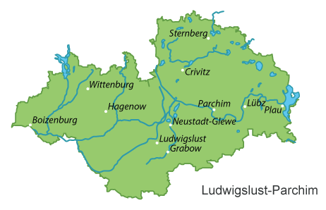
| Locations in the District LUDWIGSLUST-PARCHIM (Source: Wikipedia) |
||||||||||||


| The following Municipal Register contains all places of the "Geschichtlichen Orts-Verzeichnisses" (GOV) of CompGen in LUDWIGSLUST-PARCHIM. By activating the individual buttons in the four columns >Topo<, >SLUB<, >GOV< and >Meyers<, the geographical location of a place can be called up on a map from the geographical OpenTopoMap and Kartenforum or the place descriptions in the GOV-Ortsverzeichnis and Meyers Gazetteer. | ||||||||||||||||||||||||||
| A | B | C | D | E | F | G | H | I | J | K | L | M | N | O | P | Q | R | S | T | U | V | W | X | Y | Z | |
| Community | District | Location Type | GOV | Meyers | Parts of a Community | Type | Coordinates | Topo | WikiM | SLUB | GOV |
| Balow | Ludwigslust-Parchim | Community |  |
 |
Dorfkirche/Balow | Municipality | 53.2626 N 011.7238 E |  |
 |
 |
|
| Banzkow | Ludwigslust-Parchim | Community | |
|
Dorfkirche/Goldenstädt | Municipality | 53.4686 N 011.4996 E | |
|
|
|
| Dorfkirche/Mirow | Municipality | 53.5018 N 011.4993 E | |
|
|
|
Dorfkirche/Banzkow | Municipality | 53.5227 N 011.5166 E | |
|
|
|
| Barkhagen | Ludwigslust-Parchim | Community | |
|
Dorfkirche/Plauerhagen | Municipality | 53.4977 N 012.2111 E | |
|
|
|
| Barnin Dorf | Ludwigslust-Parchim | Community | |
|
Dorfkirche/Barnin | Municipality | 53.5979 N 011.6993 E | |
|
|
|
| Besitz | Ludwigslust-Parchim | Community | |
|
Dorfkirche/Blücher | Municipality | 53.3548 N 010.8293 E | |
|
|
|
| Blievenstorf | Ludwigslust-Parchim | Community | |
|
Dorfkirche/Blievenstorf | Municipality | 53.3619 N 011.6675 E | |
|
|
|
| Boizenburg/Elbe | Ludwigslust-Parchim | Town | |
|
St. Marien-Kirche/Boizenburg | City | 53.3754 N 010.7235 E | |
|
|
|
| Borkow | Ludwigslust-Parchim | Community | |
|
Kapelle/Borkow | Municipality | 53.6660 N 011.9528 E | |
|
|
|
| Dorfkirche/Woserin | Municipality | 53.6669 N 012.0038 E | |
|
|
|
|||||
| Brenz | Ludwigslust-Parchim | Community | |
|
Dorfkirche/Brenz | Municipality | 53.3835 N 011.6643 E | |
|
|
|
| Brüel | Ludwigslust-Parchim | Town | |
|
Stadtkirche/Brüel | City | 53.7376 N 011.7139 E | |
|
|
|
| Brunow | Ludwigslust-Parchim | Community | |
|
Dorfkirche/Brunow | Municipality | 53.2624 N 011.8100 E | |
|
|
|
| Buchberg | Ludwigslust-Parchim | Community | |
|
Dorfkirche/Gnevsdorf | Municipality | 53.4045 N 012.2151 E | |
|
|
|
| Dorfkirche/Retzow | Municipality | 53.3699 N 012.1929 E | |
|
|
|
|||||
| Bülow | Ludwigslust-Parchim | Community | |
|
Dorfkirche/Prestin | Municipality | 53.6008 N 011.8080 E | |
|
|
|
| Dorfkirche/Bülow | Municipality | 53.5914 N 011.7673 E | |
|
|
|
|||||
| Community | District | Location Type | GOV | Meyers | Parts of a Community | Type | Coordinates | Topo | WikiM | SLUB | GOV |
| Cambs | Ludwigslust-Parchim | Community | |
|
Patronatskapelle/Cambs | Municipality | 53.6949 N 011.5283 E | |
|
|
|
| Dorfkirche/Langen Brütz | Municipality | 53.6589 N 011.5479 E | |
|
|
|
|||||
| Crivitz | Ludwigslust-Parchim | Town | |
|
Dorfkirche/Wessin | City | 53.5766 N 011.7391 E | |
|
|
|
| Stadtkirche/Crivitz | City | 53.5776 N 011.6480 E | |
|
|
|
|||||
| Community | District | Location Type | GOV | Meyers | Parts of a Community | Type | Coordinates | Topo | WikiM | SLUB | GOV |
| Dabel | Ludwigslust-Parchim | Community | |
|
Dorfkirche/Dabel | Municipality | 53.6611 N 011.9052 E | |
|
|
|
| Dambeck | Ludwigslust-Parchim | Community | |
|
Dorfkirche/Dambeck | Municipality | 53.2436 N 011.7686 E | |
|
|
|
| Damm | Ludwigslust-Parchim | Community | |
|
Damm | Municipality | 53.4409 N 011.7536 E | |
|
|
|
| Demen | Ludwigslust-Parchim | Community | |
|
Dorfkirche/Demen | Municipality | 53.6314 N 011.7586 E | |
|
|
|
| Dersenow | Ludwigslust-Parchim | Community | |
|
Ev. Kapelle/Dersenow | Municipality | 53.3805 N 010.8910 E | |
|
|
|
| Dobbertin | Ludwigslust-Parchim | Community | |
|
Klosterkirche/Dobbertin | Municipality | 53.6154 N 012.0774 E | |
|
|
|
| Dobin am See | Ludwigslust-Parchim | Community | |
|
Dorfkirche/Retgendorf | Municipality | 53.7284 N 011.5027 E | |
|
|
|
| Dorfkirche/Buchholz | Municipality | 53.7427 N 011.5740 E | |
|
|
|
|||||
| Dömitz | Ludwigslust-Parchim | Town | |
|
Kapelle/Polz | City | 53.1234 N 011.3574 E | |
|
|
|
| Dömitz (Maria Rosenkranz) | City | |
Johanneskirche/Dömitz | City | 53.1417 N 011.2494 E | |
|
|
|
||
| Domsühl | Ludwigslust-Parchim | Community | |
|
Dorfkirche/Domsühl | Municipality | 53.4876 N 011.7710 E | |
|
|
|
| Dorfkirche/Bergrade | Municipality | 53.4760 N 011.8094 E | |
|
|
|
Dorfkirche/Zieslübbe | Municipality | 53.4721 N 011.7761 E | |
|
|
|
Dorfkirche/Alt Damerow | Municipality | 53.4692 N 011.7425 E | |
|
|
|
| Community | District | Location Type | GOV | Meyers | Parts of a Community | Type | Coordinates | Topo | WikiM | SLUB | GOV |
| Eldena | Ludwigslust-Parchim | Community | |
|
Johannes-Kirche/Eldena | Municipality | 53.2280 N 011.4274 E | |
|
|
|
| Community | District | Location Type | GOV | Meyers | Parts of a Community | Type | Coordinates | Topo | WikiM | SLUB | GOV |
| Friedrichsruhe | Ludwigslust-Parchim | Community | |
|
Dorfkirche/Ruthenbeck | Municipality | 53.5305 N 011.7062 E | |
|
|
|
| Dorfkirche/Frauenmark | Municipality | 53.5311 N 011.7878 E | |
|
|
|
|||||
| Community | District | Location Type | GOV | Meyers | Parts of a Community | Type | Coordinates | Topo | WikiM | SLUB | GOV |
| Gallin | Ludwigslust-Parchim | Community | |
|
Dorfkapelle/Gallin | Municipality | 53.4935 N 010.8331 E | |
|
|
|
| Gallin-Kuppentin | Ludwigslust-Parchim | Community | |
|
Dorfkirche/Kuppentin | Municipality | 53.4953 N 012.1510 E | |
|
|
|
| Ganzlin | Ludwigslust-Parchim | Community | |
|
Dorfkirche/Ganzlin | Municipality | 53.3852 N 012.2527 E | |
|
|
|
| Gehlsbach | Ludwigslust-Parchim | Community | |
|
Dorfkirche/Karbow | Municipality | 53.4030 N 012.1209 E | |
|
|
|
| Dorfkirche/Vietlübbe | Municipality | 53.3942 N 012.1319 E | |
|
|
|
|||||
| Gischow | Ludwigslust-Parchim | Community | |
|
Dorfkirche/Burow | Municipality | 53.4028 N 012.0112 E | |
|
|
|
| Dorfkirche/Gischow | Municipality | 53.4371 N 012.0109 E | |
|
|
|
|||||
| Göhren | Ludwigslust-Parchim | Community | |
|
Dorfkapelle/Göhren | Municipality | 53.5381 N 011.5998 E | |
|
|
|
| Goldberg | Ludwigslust-Parchim | Town | |
|
Stadtkirche/Goldberg(Mecklenburg) | City | 53.5903 N 012.0870 E | |
|
|
|
| Gorlosen | Ludwigslust-Parchim | Community | |
|
Dorfkirche/Gorlosen | Municipality | 53.1858 N 011.4597 E | |
|
|
|
| Grabow | Ludwigslust-Parchim | Town | |
|
Stadtkirche St Georg/Grabow | City | 53.2787 N 011.5624 E | |
|
|
|
| Granzin | Ludwigslust-Parchim | Community | |
|
Dorfkirche/Granzin | Municipality | 53.5026 N 011.9418 E | |
|
|
|
| Dorfkirche/Greven(Granzin) | Municipality | 53.4835 N 011.9769 E | |
|
|
|
|||||
| Grebs-Niendorf | Ludwigslust-Parchim | Community | |
|
Ev. Kapelle/Niendorf an der Rögnitz | Municipality | 53.2328 N 011.2587 E | |
|
|
|
| Gresse | Ludwigslust-Parchim | Community | |
|
Dorfkirche/Gresse | Municipality | 53.4281 N 010.7467 E | |
|
|
|
| Greven | Ludwigslust-Parchim | Community | |
|
Dorfkirche/Greven | Municipality | 53.4791 N 010.8006 E | |
|
|
|
| Dorfkirche/Granzin | Municipality | 53.4655 N 010.8394 E | |
|
|
|
Dorfkapelle/Lüttenmark | Municipality | 53.4520 N 010.7709 E | |
|
|
|
| Groß Godems | Ludwigslust-Parchim | Community | |
|
Dorfkirche/Groß Godems | Municipality | 53.3635 N 011.7948 E | |
|
|
|
| Groß Laasch | Ludwigslust-Parchim | Community | |
|
Dorfkirche/Groß-Laasch | Municipality | 53.3444 N 011.5575 E | |
|
|
|
| Groß Niendorf | Ludwigslust-Parchim | Community | |
|
Dorfkirche/Groß Niendorf | Municipality | 53.5904 N 011.8502 E | |
|
|
|
| Community | District | Location Type | GOV | Meyers | Parts of a Community | Type | Coordinates | Topo | WikiM | SLUB | GOV |
| Hagenow | Ludwigslust-Parchim | Town | |
|
Stadtkirche/Hagenow | City | 53.4335 N 011.1907 E | |
|
|
|
| Hagenow (St. Elisabeth von Thüringen) | City | |
|||||||||
| Hohen Pritz | Ludwigslust-Parchim | Community | |
|
Dorfkirche/Hohen Pritz | Municipality | 53.6306 N 011.8969 E | |
|
|
|
| Holthusen | Ludwigslust-Parchim | Community | |
|
Dorfkapelle/Holthusen | Municipality | 53.5415 N 011.3572 E | |
|
|
|
| Community | District | Location Type | GOV | Meyers | Parts of a Community | Type | Coordinates | Topo | WikiM | SLUB | GOV |
| Karrenzin | Ludwigslust-Parchim | Community | |
|
Dorfkirche/Karrenzin | Municipality | 53.3379 N 011.8000 E | |
|
|
|
| Ev. Kirche/Herzfeld | Municipality | 53.3242 N 011.7636 E | |
|
|
|
Dorfkirche/Wulfsahl | Municipality | 53.3221 N 011.8066 E | |
|
|
|
| Karstädt | Ludwigslust-Parchim | Community | |
|
Dorfkirche/Kardtädt | Municipality | 53.2882 N 011.4875 E | |
|
|
|
| Kirch Jesar | Ludwigslust-Parchim | Community | |
|
Dorfkirche/Kirch Jesar | Municipality | 53.4359 N 011.2744 E | |
|
|
|
| Kloster Tempzin | Ludwigslust-Parchim | Community | |
|
Klosterkirche/Tempzin | Municipality | 53.7625 N 011.6853 E | |
|
|
|
| Körchow | Ludwigslust-Parchim | Community | |
|
Dorfkirche/Körchow | Municipality | 53.4439 N 011.0632 E | |
|
|
|
| Kreien | Ludwigslust-Parchim | Community | |
|
Ev. Kapelle/Wilsen | Municipality | 53.3764 N 012.0666 E | |
|
|
|
| Dorfkirche/Kreien | Municipality | 53.4074 N 012.0550 E | |
|
|
|
|||||
| Kritzow | Ludwigslust-Parchim | Community | |
|
Dorfkirche/Benzin | Municipality | 53.4401 N 012.0828 E | |
|
|
|
| Kuhlen-Wendorf | Ludwigslust-Parchim | Community | |
|
Dorfkirche/Holzendorf | Municipality | 53.6866 N 011.6329 E | |
|
|
|
| Dorfkirche/Müsselmow | Municipality | 53.6810 N 011.6246 E | |
|
|
|
Dorfkirche/Zaschendorf | Municipality | 53.6961 N 011.6059 E | |
|
|
|
| Community | District | Location Type | GOV | Meyers | Parts of a Community | Type | Coordinates | Topo | WikiM | SLUB | GOV |
| Leezen | Ludwigslust-Parchim | Community | |
|
Dorfkirche/Zittow | Municipality | 53.6802 N 011.5287 E | |
|
|
|
| Dorfkirche/Görslow | Municipality | 53.6323 N 011.4946 E | |
|
|
|
|||||
| Leussow | Ludwigslust-Parchim | Community | |
|
Dorfkirche/Leussow | Municipality | 53.2771 N 011.2880 E | |
|
|
|
| Lewitzrand | Ludwigslust-Parchim | Community | |
|
Dorfkirche/Raduhn | Municipality | 53.4833 N 011.6868 E | |
|
|
|
| Dorfkirche/Klinken | Municipality | 53.4952 N 011.6761 E | |
|
|
|
|||||
| Lüblow | Ludwigslust-Parchim | Community | |
|
Dorfkirche/Lüblow | Municipality | 53.4166 N 011.4528 E | |
|
|
|
| Lübz | Ludwigslust-Parchim | Town | |
|
Stiftskirche/Lübz | City | 53.4636 N 012.0279 E | |
|
|
|
| Stadtkirche/Lübz | City | 53.4606 N 012.0281 E | |
|
|
|
Lübz (Herz Jesu) | City | |
Dorfkirche/Broock | City | 53.4631 N 012.1086 E | |
|
|
|
| Ludwigslust | Ludwigslust-Parchim | Town | |
|
Stadtkirche/Ludwigslust | City | 53.3308 N 011.4978 E | |
|
|
|
| Ludwigslust/Bethlehem | City | 53.3325 N 011.4971 E | |
|
|
|
Ludwigslust (St. Helena und St. Andreas) | City | |
||
| Lutheran | Ludwigslust-Parchim | Community | |
|
Dorfkirche/Lutheran | Municipality | 53.4569 N 012.0003 E | |
|
|
|
| Lüttow-Valluhn | Ludwigslust-Parchim | Community | |
|
Dorfkapelle/Valluhn | Municipality | 53.5261 N 010.8463 E | |
|
|
|
| Community | District | Location Type | GOV | Meyers | Parts of a Community | Type | Coordinates | Topo | WikiM | SLUB | GOV |
| Malliß | Ludwigslust-Parchim | Community | |
|
St Georgenkirche/Conow | Municipality | 53.2231 N 011.3315 E | |
|
|
|
| Marnitz | Ludwigslust-Parchim | Community | |
|
Kirche St. Georg/Marnitz | Municipality | 53.3173 N 011.9323 E | |
|
|
|
| Mestlin | Ludwigslust-Parchim | Community | |
|
Dorfkirche/Mestlin | Municipality | 53.5816 N 011.9294 E | |
|
|
|
| Dorfkirche/Ruest | Municipality | 53.6149 N 011.9441 E | |
|
|
|
|||||
| Milow | Ludwigslust-Parchim | Community | |
|
Deibow | Municipality | 53.1759 N 011.5307 E | |
|
|
|
| Milow | Municipality | 53.1909 N 011.5412 E | |
|
|
|
|||||
| Möllenbeck | Ludwigslust-Parchim | Community | |
|
Dorfkirche/Möllenbeck | Municipality | 53.2855 N 011.7378 E | |
|
|
|
| Moraas | Ludwigslust-Parchim | Community | |
|
Dorfkirche/Moraas | Municipality | 53.4169 N 011.3022 E | |
|
|
|
| Muchow | Ludwigslust-Parchim | Community | |
|
Dorfkirche/Muchow | Municipality | 53.3134 N 011.6882 E | |
|
|
|
| Mustin | Ludwigslust-Parchim | Community | |
|
Dorfkirche/Ruchow | Municipality | 53.7142 N 011.9830 E | |
|
|
|
| Community | District | Location Type | GOV | Meyers | Parts of a Community | Type | Coordinates | Topo | WikiM | SLUB | GOV |
| Neu Gülze | Ludwigslust-Parchim | Community | |
|
Dorfkirche/Zahrensdorf | Municipality | 53.3929 N 010.8079 E | |
|
|
|
| Neu Kaliß | Ludwigslust-Parchim | Community | |
|
Johanniskirche/Neu Kaliß | Municipality | 53.1738 N 011.2957 E | |
|
|
|
| Neu Poserin | Ludwigslust-Parchim | Community | |
|
Dorfkirche/Groß Poserin | Municipality | 53.5482 N 012.1816 E | |
|
|
|
| Neustadt-Glewe | Ludwigslust-Parchim | Town | |
|
Marienkirche/Neustadt-Glewe | City | 53.3827 N 011.5846 E | |
|
|
|
| Neustadt-Glewe (St. Ansverus) | City | |
|||||||||
| Nostorf | Ludwigslust-Parchim | Community | |
|
St. Laurentiuskirche/Zweedorf | Municipality | 53.4311 N 010.6303 E | |
|
|
|
| Dorfkirche/Rensdorf | Municipality | 53.3754 N 010.7235 E | |
|
|
|
|||||
| Community | District | Location Type | GOV | Meyers | Parts of a Community | Type | Coordinates | Topo | WikiM | SLUB | GOV |
| Obere Warnow | Ludwigslust-Parchim | Community | |
|
Dorfkirche/Kossebade | Municipality | 53.5319 N 011.8433 E | |
|
|
|
| Dorfkirche/Herzberg(Obere Warnow) | Municipality | 53.5299 N 011.9296 E | |
|
|
|
Dorfkirche/Grebbin | Municipality | 53.5153 N 011.8651 E | |
|
|
|
| Community | District | Location Type | GOV | Meyers | Parts of a Community | Type | Coordinates | Topo | WikiM | SLUB | GOV |
| Pampow | Ludwigslust-Parchim | Community | |
|
Ev. Kirche/Pampow | Municipality | 53.5707 N 011.3599 E | |
|
|
|
| Parchim | Ludwigslust-Parchim | Town | |
|
Parchim (St. Josef) | City | |
||||
| St.Georgs-Kirche/Parchim | City | 53.4277 N 011.8472 E | |
|
|
|
St.Marien-Kirche/Parchim | City | 53.4282 N 011.8406 E | |
|
|
|
| Passow | Ludwigslust-Parchim | Community | |
|
Dorfkirche/Unter Brüz | Municipality | 53.5428 N 012.0643 E | |
|
|
|
| Dorfkirche/Weisin | Municipality | 53.4989 N 012.0742 E | |
|
|
|
Dorfkirche/Passow | Municipality | 53.5071 N 012.0531 E | |
|
|
|
| Picher | Ludwigslust-Parchim | Community | |
|
Ev Kirche/Picher | Municipality | 53.3490 N 011.3461 E | |
|
|
|
| Pinnow | Ludwigslust-Parchim | Community | |
|
Pinnow (bei Schwerin) | Municipality | 53.6051 N 011.5466 E | |
|
|
|
| Plate | Ludwigslust-Parchim | Community | |
|
Ev. Kapelle/Peckatel | Municipality | 53.5561 N 011.5222 E | |
|
|
|
| Ev. Kirche/Plate | Municipality | 53.5512 N 011.4994 E | |
|
|
|
|||||
| Plau am See | Ludwigslust-Parchim | Town | |
|
Dorfkirche/Karow | City | 53.5411 N 012.2707 E | |
|
|
|
| St. Marien-Kirche/Plau am See | City | 53.4582 N 012.2613 E | |
|
|
|
|||||
| Prislich | Ludwigslust-Parchim | Community | |
|
Ev Kirche/Werle | Municipality | 53.2620 N 011.6747 E | |
|
|
|
| Dorfkirche/Neese | Municipality | 53.2642 N 011.6217 E | |
|
|
|
|||||
| Pritzier | Ludwigslust-Parchim | Community | |
|
Petruskirche/Pritzier | Municipality | 53.3786 N 011.0782 E | |
|
|
|
| Community | District | Location Type | GOV | Meyers | Parts of a Community | Type | Coordinates | Topo | WikiM | SLUB | GOV |
| Rastow | Ludwigslust-Parchim | Community | |
|
Dorfkirche/Kraak | Municipality | 53.4477 N 011.3846 E | |
|
|
|
| Redefin | Ludwigslust-Parchim | Community | |
|
Redefin | Municipality | 53.3483 N 011.2009 E | |
|
|
|
| Rom | Ludwigslust-Parchim | Community | |
|
Dorfkirche/Klein Niendorf | Municipality | 53.4211 N 011.9759 E | |
|
|
|
| Dorfkirche/Lancken | Municipality | 53.4685 N 011.9449 E | |
|
|
|
Dorfkirche/Rom | Municipality | 53.4450 N 011.9490 E | |
|
|
|
Dorfkirche/Paarsch | Municipality | 53.4274 N 011.9307 E | |
|
|
|
| Community | District | Location Type | GOV | Meyers | Parts of a Community | Type | Coordinates | Topo | WikiM | SLUB | GOV |
| Schwanheide | Ludwigslust-Parchim | Community | |
|
Dorfkapelle/Schwanheide | Municipality | 53.4290 N 010.6867 E | |
|
|
|
| St. Georgskirche/Zweedorf | Municipality | 53.4311 N 010.6303 E | |
|
|
|
|||||
| Severin | Ludwigslust-Parchim | Community | |
|
Dorfkirche/Severin | Municipality | 53.5007 N 011.7700 E | |
|
|
|
| Siggelkow | Ludwigslust-Parchim | Community | |
|
Dorfkirche/Groß Pankow | Municipality | 53.3777 N 011.9743 E | |
|
|
|
| Klein Pankow | Municipality | 53.3767 N 012.0321 E | |
|
|
|
Dorfkirche/Siggelkow | Municipality | 53.3862 N 011.9378 E | |
|
|
|
| Spornitz | Ludwigslust-Parchim | Community | |
|
Dorfkirche/Spornitz | Municipality | 53.4074 N 011.7181 E | |
|
|
|
| Dorfkirche/Dütschow | Municipality | 53.4058 N 011.6759 E | |
|
|
|
|||||
| Steesow | Ludwigslust-Parchim | Community | |
|
Bochin | Municipality | 53.1333 N 011.5135 E | |
|
|
|
| Sternberg | Ludwigslust-Parchim | Town | |
|
Dorfkirche/Gägelow | City | 53.6856 N 011.8956 E | |
|
|
|
| Stadtkirche St. Maria und St. Nikolaus/Sternberg | City | 53.7119 N 011.8302 E | |
|
|
|
Dorfkirche/Groß Raden | City | 53.7344 N 011.8642 E | |
|
|
|
| Stolpe | Ludwigslust-Parchim | Community | |
|
Dorfkirche/Stolpe | Municipality | 53.3587 N 011.7356 E | |
|
|
|
| Stralendorf | Ludwigslust-Parchim | Community | |
|
Dorfkirche/Stralendorf | Municipality | 53.5752 N 011.2989 E | |
|
|
|
| Suckow | Ludwigslust-Parchim | Community | |
|
Dorfkirche/Suckow | Municipality | 53.3096 N 011.9699 E | |
|
|
|
| Sukow | Ludwigslust-Parchim | Community | |
|
Dorfkirche/Sukow | Municipality | 53.5499 N 011.5577 E | |
|
|
|
| Sülstorf | Ludwigslust-Parchim | Community | |
|
Johanniterkirche/Sülstorf | Municipality | 53.5077 N 011.3711 E | |
|
|
|
| Dorfkirche/Sülte | Municipality | 53.5079 N 011.4279 E | |
|
|
|
|||||
| Community | District | Location Type | GOV | Meyers | Parts of a Community | Type | Coordinates | Topo | WikiM | SLUB | GOV |
| Techentin | Ludwigslust-Parchim | Community | |
|
Ev. Kirche/Techentin | Municipality | 53.5890 N 011.9869 E | |
|
|
|
| Ev. Kirche/Below | Municipality | 53.6115 N 011.9864 E | |
|
|
|
|||||
| Teldau | Ludwigslust-Parchim | Community | |
|
Dorfkapelle/Bandekow | Municipality | 53.3408 N 010.7971 E | |
|
|
|
| Tessenow | Ludwigslust-Parchim | Community | |
|
Kapelle/Dorf Poltnitz | Municipality | 53.3385 N 011.8492 E | |
|
|
|
| Toddin | Ludwigslust-Parchim | Community | |
|
Ev Kapelle/Toddin | Municipality | 53.4151 N 011.1327 E | |
|
|
|
| Tramm | Ludwigslust-Parchim | Community | |
|
Dorfkirche/Tramm | Municipality | 53.5199 N 011.6394 E | |
|
|
|
| Community | District | Location Type | GOV | Meyers | Parts of a Community | Type | Coordinates | Topo | WikiM | SLUB | GOV |
| Uelitz | Ludwigslust-Parchim | Community | |
|
Dorfkirche/Uelitz | Municipality | 53.4754 N 011.4379 E | |
|
|
|
| Community | District | Location Type | GOV | Meyers | Parts of a Community | Type | Coordinates | Topo | WikiM | SLUB | GOV |
| Vellahn | Ludwigslust-Parchim | Community | |
|
Dorfkirche/Vellahn | Municipality | 53.4021 N 010.9671 E | |
|
|
|
| Gutskirche/Melkof | Municipality | 53.3605 N 011.0241 E | |
|
|
|
Dorfkirche/Marsow | Municipality | 53.4231 N 010.9305 E | |
|
|
|
Dorfkirche/Camin | Municipality | 53.4611 N 010.9649 E | |
|
|
|
Dorfkirche Hl. Dionysius /Bennin | Municipality | 53.4509 N 010.8908 E | |
|
|
|
| Vielank | Ludwigslust-Parchim | Community | |
|
Kapelle/Woosmer | Municipality | 53.1991 N 011.1780 E | |
|
|
|
| Dorfkirche/Alt Jabel | Municipality | 53.2501 N 011.1700 E | |
|
|
|
|||||
| Community | District | Location Type | GOV | Meyers | Parts of a Community | Type | Coordinates | Topo | WikiM | SLUB | GOV |
| Warlitz | Ludwigslust-Parchim | Community | |
|
Dorfkirche/Warlitz | Municipality | 53.3786 N 011.1501 E | |
|
|
|
| Warsow | Ludwigslust-Parchim | Community | |
|
Dorfkirche/Warsow | Municipality | 53.5304 N 011.3018 E | |
|
|
|
| Weitendorf b. Brüel | Ludwigslust-Parchim | Community | |
|
Dorfkirche/Sülten | Municipality | 53.7317 N 011.7495 E | |
|
|
|
| Wendisch Priborn | Ludwigslust-Parchim | Community | |
|
Dorfkirche/Wendisch Priborn | Municipality | 53.3391 N 012.2730 E | |
|
|
|
| Wendisch Waren | Ludwigslust-Parchim | Community | |
|
Ev Kirche/Woosten | Municipality | 53.5653 N 012.1105 E | |
|
|
|
| Werder | Ludwigslust-Parchim | Community | |
|
Dorfkirche/Benthen | Municipality | 53.5166 N 012.0075 E | |
|
|
|
| Wittenburg | Ludwigslust-Parchim | Town | |
|
Wittenburg (Christus König) | City | |
||||
| St Bartholomäus-Kirche/Wittenburg | City | 53.5129 N 011.0714 E | |
|
|
|
|||||
| Wittendörp | Ludwigslust-Parchim | Community | |
|
St Vitus-Kirche/Döbbersen | Municipality | 53.5793 N 011.0718 E | |
|
|
|
| Ev. Kirche/Dreilützow | Municipality | 53.5317 N 011.1155 E | |
|
|
|
|||||
| Wittenförden | Ludwigslust-Parchim | Community | |
|
Dorfkirche/Wittenförden | Municipality | 53.6268 N 011.3305 E | |
|
|
|
| Witzin | Ludwigslust-Parchim | Community | |
|
Dorfkirche/Witzin | Municipality | 53.7241 N 011.9203 E | |
|
|
|
| Wöbbelin | Ludwigslust-Parchim | Community | |
|
Dorfkirche/Wöbbelin | Municipality | 53.3993 N 011.5037 E | |
|
|
|
| Community | District | Location Type | GOV | Meyers | Parts of a Community | Type | Coordinates | Topo | WikiM | SLUB | GOV |
| Zapel | Ludwigslust-Parchim | Community | |
|
Dorfkirche/Zapel | Municipality | 53.5533 N 011.6652 E | |
|
|
|
| Zarrentin am Schaalsee | Ludwigslust-Parchim | Town | |
|
St Abundus-Kirche/Lassahn | City | 53.6022 N 010.9534 E | |
|
|
|
| Dorf- und Klosterkirche/Zarrentin | City | 53.5542 N 010.9176 E | |
|
|
|
Ev. Kirche/Neuhof (Zarrentin am Schaalsee) | City | 53.5698 N 010.9992 E | |
|
|
|
| Ziegendorf | Ludwigslust-Parchim | Community | |
|
Dorfkirche/Drefahl | Municipality | 53.2876 N 011.8639 E | |
|
|
|
| Dorfkirche/Meierstorf | Municipality | 53.3058 N 011.8602 E | |
|
|
|
Dorfkirche/Ziegendorf | Municipality | 53.2953 N 011.8089 E | |
|
|
|
| Zierzow | Ludwigslust-Parchim | Community | |
|
Dorfkirche/Zierzow | Municipality | 53.2860 N 011.6838 E | |
|
|
|
| Zölkow | Ludwigslust-Parchim | Community | |
|
Dorfkirche/Kladrum | Municipality | 53.5592 N 011.7947 E | |
|
|
|
|
||||||||||