|
|||||||||||
| District MAIN-TAUBER-KREIS - Locations Register - |
|||||||||||
|
|
|
||||||||||
| District MAIN-TAUBER-KREIS on the map of Germany (Source: Wikipedia) |
District MAIN-TAUBER-KREIS on the map of Baden-Wuerttemberg (Source: Wikipedia) |
|||||||||||
|
||||||||||||
|
||||||||||||
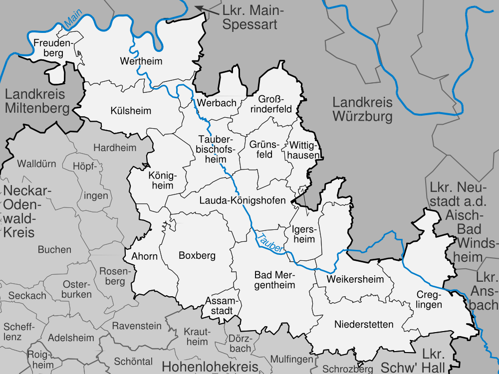
| Locations in the District MAIN-TAUBER-KREIS (Source: Wikipedia) |
||||||||||||


| The following Ortsregister contains all places of the "Geschichtlichen Orts-Verzeichnisses" (GOV) of CompGen in MAIN-TAUBER-KREIS. By activating the individual buttons in the four columns >Topo<, >SLUB<, >GOV< and >Meyers<, the geographical location of a place can be called up on a map from the geographical OpenTopoMap and Kartenforum or the place descriptions in the GOV-Ortsverzeichnis and Meyers Gazetteer. | ||||||||||||||||||||||||||
| A | B | C | D | E | F | G | H | I | J | K | L | M | N | O | P | Q | R | S | T | U | V | W | X | Y | Z | |
| Location | Distict | Location Typ | Coordinates | Topo | SLUB | GOV | Meyers | Community affiliation |
| Adolzhausen | Main-Tauber-Kreis | Parish Village | 49.4000 N 009.8700 E |  |
 |
 |
 |
Niederstetten |
| Ahorn-Buch | Main-Tauber-Kreis | Locality | 49.5300 N 009.5500 E | |
|
|
|
Ahorn |
| Ahornhof | Main-Tauber-Kreis | Place | 49.5300 N 009.5800 E | |
|
|
|
Ahorn |
| Altes Bahnwärterhaus | Main-Tauber-Kreis | Residential Area | 49.7052 N 009.6110 E | |
|
|
|
Werbach |
| Althausen | Main-Tauber-Kreis | Locality | 49.4700 N 009.7300 E | |
|
|
|
Bad Mergentheim |
| Am Flugplatz | Main-Tauber-Kreis | Residential Area | 49.3969 N 009.9570 E | |
|
|
|
Niederstetten |
| Am Kirchenweg | Main-Tauber-Kreis | Residential Area | 49.7384 N 009.4836 E | |
|
|
|
Wertheim |
| Angeltürn | Main-Tauber-Kreis | Locality | 49.4800 N 009.5800 E | |
|
|
|
Boxberg |
| Antonsmühle | Main-Tauber-Kreis | Place | 49.7479 N 009.4008 E | |
|
|
|
Freudenberg |
| Apfelbach | Main-Tauber-Kreis | Locality | 49.4300 N 009.8200 E | |
|
|
|
Bad Mergentheim |
| Archshofen | Main-Tauber-Kreis | Parish Village | 49.4533 N 010.0690 E | |
|
|
|
Creglingen |
| Assamstadt | Main-Tauber-Kreis | Parish Village | 49.4300 N 009.6800 E | |
|
|
|
Königsbronn |
| Assamstadt | Main-Tauber-Kreis | Residential Area | 49.4272 N 009.6889 E | |
|
|
|
Assamstadt |
| Location | Distict | Location Typ | Coordinates | Topo | SLUB | GOV | Meyers | Community affiliation |
| Bahnhof Dittwar | Main-Tauber-Kreis | Residential Area | 49.6060 N 009.6431 E | |
|
|
|
Tauberbischofsheim |
| Beckstein | Main-Tauber-Kreis | Locality | 49.5300 N 009.7000 E | |
|
|
|
Lauda-Königshofen |
| Bernsfelden | Main-Tauber-Kreis | Parish Village | 49.5500 N 009.8800 E | |
|
|
|
Igersheim |
| Berolzheim | Main-Tauber-Kreis | Locality | 49.4748 N 009.5404 E | |
|
|
|
Ahorn |
| Bestenheid | Main-Tauber-Kreis | City Subdistrict | 49.7824 N 009.4995 E | |
|
|
|
Wertheim |
| Bestenheider Höhe | Main-Tauber-Kreis | Residential Area | 49.7663 N 009.5008 E | |
|
|
|
Wertheim |
| Birkenfeld | Main-Tauber-Kreis | Hamlet | 49.5700 N 009.5500 E | |
|
|
|
Königheim |
| Birkhof | Main-Tauber-Kreis | Place | 49.6996 N 009.4418 E | |
|
|
|
Külsheim |
| Birkhöfe | Main-Tauber-Kreis | Place | 49.4032 N 010.0311 E | |
|
|
|
Creglingen |
| Blankenmühle | Main-Tauber-Kreis | Place | 49.7419 N 009.4040 E | |
|
|
|
Freudenberg |
| Blauer Rain | Main-Tauber-Kreis | Residential Area | 49.6742 N 009.6517 E | |
|
|
|
Werbach |
| Blumweiler | Main-Tauber-Kreis | District | |
|
Creglingen | |||
| Bobstadt | Main-Tauber-Kreis | Locality | 49.4500 N 009.6700 E | |
|
|
|
Boxberg |
| Boxberger Klingehof | Main-Tauber-Kreis | Deserted Settlement | 49.4420 N 009.6523 E | |
|
|
|
Boxberg |
| Boxtal | Main-Tauber-Kreis | Locality | |
|
Freudenberg | |||
| Brehmen | Main-Tauber-Kreis | District | 49.5500 N 009.5500 E | |
|
|
|
Königheim |
| Bronn | Main-Tauber-Kreis | Hamlet | 49.4300 N 009.8800 E | |
|
|
|
Weikersheim |
| Brunntal | Main-Tauber-Kreis | Locality | 49.6834 N 009.6955 E | |
|
|
|
Werbach |
| Location | Distict | Location Typ | Coordinates | Topo | SLUB | GOV | Meyers | Community affiliation |
| Craintal | Main-Tauber-Kreis | Village | 49.4625 N 010.0552 E | |
|
|
|
Creglingen |
| Location | Distict | Location Typ | Coordinates | Topo | SLUB | GOV | Meyers | Community affiliation |
| Daimbach | Main-Tauber-Kreis | Locality | 49.4967 N 009.7137 E | |
|
|
|
Bad Mergentheim |
| Dertingen | Main-Tauber-Kreis | Locality | 49.7633 N 009.6177 E | |
|
|
|
Wertheim |
| Deubach | Main-Tauber-Kreis | Locality | 49.5300 N 009.7700 E | |
|
|
|
Lauda-Königshofen |
| Dienstadt | Main-Tauber-Kreis | Locality | 49.6343 N 009.6120 E | |
|
|
|
Tauberbischofsheim |
| Dietenhan | Main-Tauber-Kreis | Locality | 49.7432 N 009.6071 E | |
|
|
|
Wertheim |
| Distelhausen | Main-Tauber-Kreis | Locality | 49.5800 N 009.6800 E | |
|
|
|
Tauberbischofsheim |
| Distelhausen, Bahnstation | Main-Tauber-Kreis | Residential Area | 49.5999 N 009.6851 E | |
|
|
|
Tauberbischofsheim |
| Dittwar | Main-Tauber-Kreis | Locality | 49.5800 N 009.6300 E | |
|
|
|
Tauberbischofsheim |
| Dorfmühle | Main-Tauber-Kreis | Residential Area | 49.6915 N 009.6008 E | |
|
|
|
Werbach |
| Dörlesberg | Main-Tauber-Kreis | Locality | 49.7129 N 009.5025 E | |
|
|
|
Wertheim |
| Drittberg | Main-Tauber-Kreis | Place | 49.4864 N 009.7490 E | |
|
|
|
Bad Mergentheim |
| Dürrhof | Main-Tauber-Kreis | Deserted Settlement | 49.4477 N 009.9518 E | |
|
|
|
Weikersheim |
| Dürrhof | Main-Tauber-Kreis | Place | |
|
Freudenberg |
| Location | Distict | Location Typ | Coordinates | Topo | SLUB | GOV | Meyers | Community affiliation |
| Ebenheid | Main-Tauber-Kreis | Locality | 49.7155 N 009.3602 E | |
|
|
|
Freudenberg |
| Ebenmühle | Main-Tauber-Kreis | Place | 49.7101 N 009.5159 E | |
|
|
|
Wertheim |
| Edelfingen | Main-Tauber-Kreis | Locality | 49.5000 N 009.7500 E | |
|
|
|
Bad Mergentheim |
| ehemalige Kurmainz-Kaserne | Main-Tauber-Kreis | Residential Area | 49.6216 N 009.6791 E | |
|
|
|
Tauberbischofsheim |
| Eichel | Main-Tauber-Kreis | City Subdistrict | 49.7641 N 009.5370 E | |
|
|
|
Wertheim |
| Eichgrundsiedlung | Main-Tauber-Kreis | Place | 49.7358 N 009.5497 E | |
|
|
|
Wertheim |
| Elpersheim | Main-Tauber-Kreis | District | 49.4700 N 009.8700 E | |
|
|
|
Weikersheim |
| Emmentaler Mühle | Main-Tauber-Kreis | Place | 49.6866 N 009.6839 E | |
|
|
|
Werbach |
| Epplingen | Main-Tauber-Kreis | Locality | 49.5056 N 009.6272 E | |
|
|
|
Boxberg |
| Erdbach | Main-Tauber-Kreis | Hamlet | 49.4800 N 010.0649 E | |
|
|
|
Creglingen |
| Ernsthof | Main-Tauber-Kreis | Place | 49.7057 N 009.4837 E | |
|
|
|
Wertheim |
| Ernsthofsiedlung | Main-Tauber-Kreis | Residential Area | 49.7067 N 009.4943 E | |
|
|
|
Wertheim |
| Esselbrunn | Main-Tauber-Kreis | Hamlet | 49.5700 N 009.5800 E | |
|
|
|
Königheim |
| Eubigheim | Main-Tauber-Kreis | Locality | 49.4800 N 009.5300 E | |
|
|
|
Ahorn |
| Eulschirben | Main-Tauber-Kreis | Place | 49.6995 N 009.5774 E | |
|
|
|
Werbach |
| Location | Distict | Location Typ | Coordinates | Topo | SLUB | GOV | Meyers | Community affiliation |
| Finsterlohr | Main-Tauber-Kreis | Parish Village | 49.4346 N 010.0944 E | |
|
|
|
Creglingen |
| Frauental | Main-Tauber-Kreis | Village | 49.4965 N 010.0909 E | |
|
|
|
Creglingen |
| Freudenbach | Main-Tauber-Kreis | Parish Village | 49.4742 N 010.0966 E | |
|
|
|
Creglingen |
| Fuchshof | Main-Tauber-Kreis | Farmstead | 49.4979 N 010.0823 E | |
|
|
|
Creglingen |
| Location | Distict | Location Typ | Coordinates | Topo | SLUB | GOV | Meyers | Community affiliation |
| Gamburg | Main-Tauber-Kreis | Locality | 49.6935 N 009.6011 E | |
|
|
|
Werbach |
| Gamburg, Bahnstation | Main-Tauber-Kreis | Residential Area | 49.6981 N 009.5949 E | |
|
|
|
Werbach |
| Geiersmühle | Main-Tauber-Kreis | Deserted Place | 49.6427 N 009.8544 E | |
|
|
|
Wittighausen |
| Gerchsheim | Main-Tauber-Kreis | Locality | 49.7066 N 009.7847 E | |
|
|
|
Großrinderfeld |
| Gerlachsheim | Main-Tauber-Kreis | City Subdistrict | 49.5700 N 009.7200 E | |
|
|
|
Lauda-Königshofen |
| Gickelhof | Main-Tauber-Kreis | Place | |
|
Külsheim | |||
| Gissigheim | Main-Tauber-Kreis | District | 49.5800 N 009.5800 E | |
|
|
|
Königheim |
| Glashütte | Main-Tauber-Kreis | Place | 49.7863 N 009.4870 E | |
|
|
|
Wertheim |
| Gräffingen | Main-Tauber-Kreis | Place | 49.5200 N 009.5700 E | |
|
|
|
Ahorn |
| Graubüttelbrunn, Haltestelle | Main-Tauber-Kreis | Residential Area | 49.6369 N 009.8552 E | |
|
|
|
Wittighausen |
| Grenzenmühle | Main-Tauber-Kreis | Houses | 49.6206 N 009.8557 E | |
|
|
|
Wittighausen |
| Großrinderfeld | Main-Tauber-Kreis | Residential Area | 49.6700 N 009.7300 E | |
|
|
|
Großrinderfeld |
| Grünenwört | Main-Tauber-Kreis | Locality | 49.7731 N 009.4716 E | |
|
|
|
Wertheim |
| Grünsfeldhausen | Main-Tauber-Kreis | District | 49.6246 N 009.7408 E | |
|
|
|
Grünsfeld |
| Location | Distict | Location Typ | Coordinates | Topo | SLUB | GOV | Meyers | Community affiliation |
| Haagen | Main-Tauber-Kreis | Village | 49.4300 N 009.9200 E | |
|
|
|
Weikersheim |
| Hachtel | Main-Tauber-Kreis | Locality | 49.4200 N 009.7800 E | |
|
|
|
Bad Mergentheim |
| Hagenmühle | Main-Tauber-Kreis | Place | 49.4877 N 009.6130 E | |
|
|
|
Boxberg |
| Haidhof | Main-Tauber-Kreis | Place | 49.7523 N 009.5335 E | |
|
|
|
Wertheim |
| Harthausen | Main-Tauber-Kreis | Parish Village | 49.5200 N 009.8300 E | |
|
|
|
Igersheim |
| Heckfeld | Main-Tauber-Kreis | Locality | 49.5500 N 009.6300 E | |
|
|
|
Lauda-Königshofen |
| Heidenkessel | Main-Tauber-Kreis | Place | 49.5967 N 009.6449 E | |
|
|
|
Tauberbischofsheim |
| Herbsthausen | Main-Tauber-Kreis | Locality | 49.4000 N 009.8200 E | |
|
|
|
Bad Mergentheim |
| Herrenzimmern | Main-Tauber-Kreis | Village | 49.4200 N 009.8500 E | |
|
|
|
Niederstetten |
| Hinterer Messhof | Main-Tauber-Kreis | Place | 49.6749 N 009.4392 E | |
|
|
|
Külsheim |
| Hochhausen | Main-Tauber-Kreis | Locality | 49.6600 N 009.6372 E | |
|
|
|
Tauberbischofsheim |
| Hof Baiertal | Main-Tauber-Kreis | Hamlet | 49.6837 N 009.7298 E | |
|
|
|
Großrinderfeld |
| Hof Steinbach | Main-Tauber-Kreis | Residential Area | 49.5944 N 009.6571 E | |
|
|
|
Tauberbischofsheim |
| Hof Uhlberg | Main-Tauber-Kreis | Hamlet | 49.6194 N 009.7851 E | |
|
|
|
Grünsfeld |
| Hoffeld | Main-Tauber-Kreis | Hamlet | 49.5800 N 009.5300 E | |
|
|
|
Königheim |
| Hofgarten | Main-Tauber-Kreis | Residential Area | 49.7640 N 009.5378 E | |
|
|
|
Wertheim |
| Hofstetten | Main-Tauber-Kreis | Hamlet | 49.5700 N 009.7500 E | |
|
|
|
Lauda-Königshofen |
| Höhefeld | Main-Tauber-Kreis | Locality | 49.7134 N 009.6114 E | |
|
|
|
Wertheim |
| Hohenstadt | Main-Tauber-Kreis | Locality | 49.4916 N 009.5164 E | |
|
|
|
Ahorn |
| Hohenstraße | Main-Tauber-Kreis | Residential Area | 49.6510 N 009.6724 E | |
|
|
|
Tauberbischofsheim |
| Honsbronn | Main-Tauber-Kreis | District | 49.4500 N 009.9000 E | |
|
|
|
Weikersheim |
| Location | Distict | Location Typ | Coordinates | Topo | SLUB | GOV | Meyers | Community affiliation |
| Igelstrut | Main-Tauber-Kreis | Deserted Settlement | 49.3999 N 009.7760 E | |
|
|
|
Bad Mergentheim |
| Igersheim | Main-Tauber-Kreis | Parish Village | 49.5000 N 009.8200 E | |
|
|
|
Igersheim |
| Ihmet | Main-Tauber-Kreis | Residential Area | 49.6377 N 009.8559 E | |
|
|
|
Wittighausen |
| Ilmspan | Main-Tauber-Kreis | Locality | 49.6668 N 009.7911 E | |
|
|
|
Großrinderfeld |
| Im Loch | Main-Tauber-Kreis | Place | 49.7367 N 009.4295 E | |
|
|
|
Wertheim |
| Im Tal | Main-Tauber-Kreis | Residential Area | 49.7384 N 009.4303 E | |
|
|
|
Wertheim |
| Impfingen | Main-Tauber-Kreis | Place | 49.6480 N 009.6576 E | |
|
|
|
Tauberbischofsheim |
| Location | Distict | Location Typ | Coordinates | Topo | SLUB | GOV | Meyers | Community affiliation |
| Jungheidsiedlung | Main-Tauber-Kreis | Place | 49.7291 N 009.5596 E | |
|
|
|
Wertheim |
| Location | Distict | Location Typ | Coordinates | Topo | SLUB | GOV | Meyers | Community affiliation |
| Kembach | Main-Tauber-Kreis | Locality | 49.7425 N 009.6273 E | |
|
|
|
Wertheim |
| Kettenmühle | Main-Tauber-Kreis | Houses | 49.5945 N 009.5774 E | |
|
|
|
Königheim |
| Kloster Bronnbach | Main-Tauber-Kreis | Monastery | 49.7125 N 009.5476 E | |
|
|
|
Wertheim |
| Klosterhöhe | Main-Tauber-Kreis | Place | 49.7486 N 009.5723 E | |
|
|
|
Wertheim |
| Klosterweg | Main-Tauber-Kreis | Place | 49.7356 N 009.5745 E | |
|
|
|
Wertheim |
| Königheim | Main-Tauber-Kreis | Market Town | 49.6180 N 009.5942 E | |
|
|
|
Königheim |
| Königshofen (Baden) | Main-Tauber-Kreis | City Subdistrict | 49.5470 N 009.7323 E | |
|
|
|
Lauda-Königshofen |
| Krensheim | Main-Tauber-Kreis | District | 49.6371 N 009.7620 E | |
|
|
|
Grünsfeld |
| Kreuzstraße | Main-Tauber-Kreis | Residential Area | 49.4592 N 009.8910 E | |
|
|
|
Weikersheim |
| Kupprichhausen | Main-Tauber-Kreis | Locality | 49.5200 N 009.6200 E | |
|
|
|
Boxberg |
| Kützbrunn | Main-Tauber-Kreis | District | 49.5700 N 009.7500 E | |
|
|
|
Grünsfeld |
| Location | Distict | Location Typ | Coordinates | Topo | SLUB | GOV | Meyers | Community affiliation |
| Langenmühle | Main-Tauber-Kreis | Houses | 49.6110 N 009.8442 E | |
|
|
|
Wittighausen |
| Lauda | Main-Tauber-Kreis | City Subdistrict | 49.5703 N 009.7025 E | |
|
|
|
Lauda-Königshofen |
| Laudenbach | Main-Tauber-Kreis | Parish Village | 49.4500 N 009.9200 E | |
|
|
|
Weikersheim |
| Laukenhof | Main-Tauber-Kreis | Place | 49.7427 N 009.3541 E | |
|
|
|
Freudenberg |
| Lengenrieden | Main-Tauber-Kreis | Locality | 49.5200 N 009.6300 E | |
|
|
|
Boxberg |
| Lerchenrain | Main-Tauber-Kreis | Residential Area | 49.5866 N 009.6508 E | |
|
|
|
Tauberbischofsheim |
| Lichtenhöfe | Main-Tauber-Kreis | Hamlet | 49.5250 N 009.8700 E | |
|
|
|
Weikersheim |
| Lilach | Main-Tauber-Kreis | Hamlet | 49.6520 N 009.8256 E | |
|
|
|
Wittighausen |
| Lindelbach | Main-Tauber-Kreis | Locality | 49.7576 N 009.5847 E | |
|
|
|
Wertheim |
| Lindhelle | Main-Tauber-Kreis | Residential Area | 49.6937 N 009.5940 E | |
|
|
|
Werbach |
| Löffelstelzen | Main-Tauber-Kreis | Locality | 49.5000 N 009.7800 E | |
|
|
|
Bad Mergentheim |
| Location | Distict | Location Typ | Coordinates | Topo | SLUB | GOV | Meyers | Community affiliation |
| Marbach a d Tauber | Main-Tauber-Kreis | Locality | 49.5500 N 009.7200 E | |
|
|
|
Lauda-Königshofen |
| Markelsheim | Main-Tauber-Kreis | Locality | 49.4700 N 009.8200 E | |
|
|
|
Bad Mergentheim |
| Marstadt | Main-Tauber-Kreis | Farmstead | 49.5500 N 009.8000 E | |
|
|
|
Lauda-Königshofen |
| Messelhausen | Main-Tauber-Kreis | Locality | 49.5700 N 009.7800 E | |
|
|
|
Lauda-Königshofen |
| Mittelhof | Main-Tauber-Kreis | Place | 49.7195 N 009.5707 E | |
|
|
|
Wertheim |
| Mittelmühle | Main-Tauber-Kreis | Place | |
|
Boxberg | |||
| Mönchshof b. Bad Mergentheim | Main-Tauber-Kreis | Place | |
|
Bad Mergentheim | |||
| Mondfeld | Main-Tauber-Kreis | Locality | 49.7837 N 009.4174 E | |
|
|
|
Wertheim |
| Münster | Main-Tauber-Kreis | Parish Village | 49.4422 N 010.0372 E | |
|
|
|
Creglingen |
| Location | Distict | Location Typ | Coordinates | Topo | SLUB | GOV | Meyers | Community affiliation |
| Nassau | Main-Tauber-Kreis | Parish Village | 49.5200 N 009.8800 E | |
|
|
|
Weikersheim |
| Nassig | Main-Tauber-Kreis | Locality | 49.7353 N 009.4502 E | |
|
|
|
Wertheim |
| Neidelsbach | Main-Tauber-Kreis | Hamlet | 49.5146 N 009.5338 E | |
|
|
|
Ahorn |
| Neubronn | Main-Tauber-Kreis | Parish Village | 49.4648 N 009.9700 E | |
|
|
|
Weikersheim |
| Neuhof | Main-Tauber-Kreis | Place | 49.7472 N 009.4809 E | |
|
|
|
Wertheim |
| Neumühle | Main-Tauber-Kreis | Place | 49.6952 N 009.6954 E | |
|
|
|
Werbach |
| Neumühle | Main-Tauber-Kreis | Residential Area | 49.6952 N 009.6954 E | |
|
|
|
Werbach |
| Neumühle | Main-Tauber-Kreis | Houses | 49.6098 N 009.8522 E | |
|
|
|
Wittighausen |
| Neunkirchen | Main-Tauber-Kreis | Locality | 49.4700 N 009.7500 E | |
|
|
|
Bad Mergentheim |
| Neuses | Main-Tauber-Kreis | District | 49.5000 N 009.8500 E | |
|
|
|
Igersheim |
| Neuweiler | Main-Tauber-Kreis | Place | 49.3900 N 009.9200 E | |
|
|
|
Niederstetten |
| Niederrimbach | Main-Tauber-Kreis | Village | 49.4700 N 009.9800 E | |
|
|
|
Creglingen |
| Niedersteinach | Main-Tauber-Kreis | Hamlet | 49.5051 N 010.0600 E | |
|
|
|
Creglingen |
| Niklashausen | Main-Tauber-Kreis | Locality | 49.7039 N 009.6157 E | |
|
|
|
Werbach |
| Location | Distict | Location Typ | Coordinates | Topo | SLUB | GOV | Meyers | Community affiliation |
| Oberbalbach | Main-Tauber-Kreis | Locality | 49.5300 N 009.7800 E | |
|
|
|
Lauda-Königshofen |
| Obereubigheim | Main-Tauber-Kreis | Hamlet | 49.5000 N 009.5500 E | |
|
|
|
Ahorn |
| Oberlauda | Main-Tauber-Kreis | City Subdistrict | 49.5500 N 009.6700 E | |
|
|
|
Lauda-Königshofen |
| Oberrimbach | Main-Tauber-Kreis | District | 49.4080 N 010.0572 E | |
|
|
|
Creglingen |
| Oberschüpf | Main-Tauber-Kreis | Locality | 49.5200 N 009.6700 E | |
|
|
|
Boxberg |
| Oberstetten | Main-Tauber-Kreis | Parish Village | 49.3700 N 009.9300 E | |
|
|
|
Niederstetten |
| Oberwittighausen | Main-Tauber-Kreis | District | 49.6260 N 009.8515 E | |
|
|
|
Wittighausen |
| Ödengesäß | Main-Tauber-Kreis | Place | 49.7386 N 009.4621 E | |
|
|
|
Wertheim |
| Ödengesäßer Hof | Main-Tauber-Kreis | Place | 49.7422 N 009.4609 E | |
|
|
|
Wertheim |
| Öl- und Sägmühle | Main-Tauber-Kreis | Place | 49.6909 N 009.6897 E | |
|
|
|
Werbach |
| Ölmühle | Main-Tauber-Kreis | Residential Area | 49.6931 N 009.6907 E | |
|
|
|
Werbach |
| Otterhof | Main-Tauber-Kreis | Deserted Settlement | 49.6859 N 009.4182 E | |
|
|
|
Külsheim |
| Location | Distict | Location Typ | Coordinates | Topo | SLUB | GOV | Meyers | Community affiliation |
| Paimar | Main-Tauber-Kreis | Locality | 49.6396 N 009.7531 E | |
|
|
|
Grünsfeld |
| Palmbach | Main-Tauber-Kreis | District | 48.9460 N 008.4820 E | |
|
|
|
Grünsfeld |
| Pfitzingen | Main-Tauber-Kreis | Locality | 49.4200 N 009.8800 E | |
|
|
|
Niederstetten |
| Poppenhausen | Main-Tauber-Kreis | District | 49.6310 N 009.8263 E | |
|
|
|
Wittighausen |
| Pülfringen | Main-Tauber-Kreis | District | 49.5700 N 009.5200 E | |
|
|
|
Königheim |
| Location | Distict | Location Typ | Coordinates | Topo | SLUB | GOV | Meyers | Community affiliation |
| Queckbronn | Main-Tauber-Kreis | District | 49.4700 N 009.9300 E | |
|
|
|
Weikersheim |
| Location | Distict | Location Typ | Coordinates | Topo | SLUB | GOV | Meyers | Community affiliation |
| Rauenberg | Main-Tauber-Kreis | Locality | 49.7408 N 009.3838 E | |
|
|
|
Freudenberg |
| Reicholzheim | Main-Tauber-Kreis | Locality | 49.7277 N 009.5349 E | |
|
|
|
Wertheim |
| Reicholzheim, Bahnstation | Main-Tauber-Kreis | Residential Area | 49.7312 N 009.5283 E | |
|
|
|
Wertheim |
| Reinhardshof | Main-Tauber-Kreis | Residential Area | 49.7563 N 009.5011 E | |
|
|
|
Wertheim |
| Reinsbronn | Main-Tauber-Kreis | Locality | 49.4972 N 010.0417 E | |
|
|
|
Creglingen |
| Rengershausen | Main-Tauber-Kreis | Locality | 49.4000 N 009.7200 E | |
|
|
|
Bad Mergentheim |
| Renztal | Main-Tauber-Kreis | Residential Area | 49.7814 N 009.6280 E | |
|
|
|
Wertheim |
| Riedmühle | Main-Tauber-Kreis | Houses | 49.6027 N 009.7393 E | |
|
|
|
Grünsfeld |
| Rinderfeld | Main-Tauber-Kreis | Locality | 49.4200 N 009.9800 E | |
|
|
|
Niederstetten |
| Rosenmühle | Main-Tauber-Kreis | Place | 49.7720 N 009.4030 E | |
|
|
|
Wertheim |
| Rot (Tauber) | Main-Tauber-Kreis | Locality | 49.4000 N 009.8000 E | |
|
|
|
Bad Mergentheim |
| Rüsselhausen | Main-Tauber-Kreis | Place | 49.4423 N 009.8547 E | |
|
|
|
Niederstetten |
| Rüsselhausen | Main-Tauber-Kreis | Locality | 49.4423 N 009.8547 E | |
|
|
|
Niederstetten |
| Location | Distict | Location Typ | Coordinates | Topo | SLUB | GOV | Meyers | Community affiliation |
| Sachsenflur | Main-Tauber-Kreis | Locality | 49.5200 N 009.7000 E | |
|
|
|
Lauda-Königshofen |
| Sachsenhausen | Main-Tauber-Kreis | Locality | 49.7314 N 009.4911 E | |
|
|
|
Wertheim |
| Sägmühlen | Main-Tauber-Kreis | Residential Area | 49.7497 N 009.3992 E | |
|
|
|
Freudenberg |
| Schafhof | Main-Tauber-Kreis | Place | 49.7210 N 009.5584 E | |
|
|
|
Wertheim |
| Schäftersheim | Main-Tauber-Kreis | Locality | 49.4800 N 009.8800 E | |
|
|
|
Weikersheim |
| Schillingstadt Baden | Main-Tauber-Kreis | Locality | 49.4700 N 009.5700 E | |
|
|
|
Ahorn |
| Schlossberg | Main-Tauber-Kreis | Residential Area | 49.6979 N 009.6046 E | |
|
|
|
Werbach |
| Schmerbach | Main-Tauber-Kreis | Parish Village | 49.4113 N 010.0691 E | |
|
|
|
Creglingen |
| Schneidmühle | Main-Tauber-Kreis | Place | 49.6767 N 009.6738 E | |
|
|
|
Werbach |
| Schneidmühle | Main-Tauber-Kreis | Place | 49.4629 N 009.8467 E | |
|
|
|
Bad Mergentheim |
| Schön | Main-Tauber-Kreis | Hamlet | 49.4564 N 010.0837 E | |
|
|
|
Creglingen |
| Schönfeld | Main-Tauber-Kreis | Locality | 49.6771 N 009.8014 E | |
|
|
|
Großrinderfeld |
| Schorndorf | Main-Tauber-Kreis | Deserted Settlement | 49.4501 N 009.9347 E | |
|
|
|
Weikersheim |
| Schüleshof | Main-Tauber-Kreis | Deserted Settlement | 49.5092 N 009.9022 E | |
|
|
|
Weikersheim |
| Schwabhausen | Main-Tauber-Kreis | Locality | 49.4500 N 009.6000 E | |
|
|
|
Boxberg |
| Schwarzenbrunn | Main-Tauber-Kreis | Hamlet | 49.5300 N 009.5200 E | |
|
|
|
Ahorn |
| Schweigern | Main-Tauber-Kreis | Locality | |
|
Boxberg | |||
| Schweigern | Main-Tauber-Kreis | Village | 49.4800 N 009.6500 E | |
|
|
|
Boxberg |
| Sechselbach | Main-Tauber-Kreis | Hamlet | 49.5150 N 010.0692 E | |
|
|
|
Creglingen |
| Seehof | Main-Tauber-Kreis | Place | 49.4300 N 009.6300 E | |
|
|
|
Boxberg |
| Seemühle | Main-Tauber-Kreis | Place | 49.7063 N 009.7078 E | |
|
|
|
Werbach |
| Siedlung | Main-Tauber-Kreis | Residential Area | 49.6409 N 009.8247 E | |
|
|
|
Wittighausen |
| Siedlung Maisenbach | Main-Tauber-Kreis | Place | 49.6743 N 009.5900 E | |
|
|
|
Külsheim |
| Siedlung Mehlen | Main-Tauber-Kreis | Residential Area | 49.6890 N 009.7184 E | |
|
|
|
Werbach |
| Simmringen | Main-Tauber-Kreis | Parish Village | 49.5700 N 009.9000 E | |
|
|
|
Igersheim |
| Sonderriet | Main-Tauber-Kreis | Locality | 49.7181 N 009.4389 E | |
|
|
|
Wertheim |
| Sonnenberg | Main-Tauber-Kreis | Residential Area | 49.7470 N 009.6221 E | |
|
|
|
Wertheim |
| Standorf | Main-Tauber-Kreis | Hamlet | 49.4300 N 009.9800 E | |
|
|
|
Niederstetten |
| Steinbach | Main-Tauber-Kreis | City Subdistrict | 49.6800 N 009.4713 E | |
|
|
|
Külsheim |
| Steinbach | Main-Tauber-Kreis | Hamlet | 49.5800 N 009.6500 E | |
|
|
|
Tauberbischofsheim |
| Steinfurt | Main-Tauber-Kreis | City Subdistrict | 49.6481 N 009.4838 E | |
|
|
|
Külsheim |
| Steingasse | Main-Tauber-Kreis | Place | 49.7360 N 009.4318 E | |
|
|
|
Wertheim |
| Steinig | Main-Tauber-Kreis | Residential Area | 49.6782 N 009.6381 E | |
|
|
|
Werbach |
| Stuppach | Main-Tauber-Kreis | Locality | 49.4300 N 009.7500 E | |
|
|
|
Bad Mergentheim |
| Location | Distict | Location Typ | Coordinates | Topo | SLUB | GOV | Meyers | Community affiliation |
| Talmühle | Main-Tauber-Kreis | Houses | 49.4754 N 009.6700 E | |
|
|
|
Boxberg |
| Taubertsbronn | Main-Tauber-Kreis | Deserted Settlement | 49.5177 N 009.7887 E | |
|
|
|
Bad Mergentheim |
| Teilbacher Mühle | Main-Tauber-Kreis | Place | 49.7356 N 009.5177 E | |
|
|
|
Wertheim |
| Tiefentalerhof | Main-Tauber-Kreis | Place | 49.6978 N 009.4262 E | |
|
|
|
Külsheim |
| Tremhof | Main-Tauber-Kreis | Farmstead | 49.7718 N 009.3621 E | |
|
|
|
Freudenberg |
| Location | Distict | Location Typ | Coordinates | Topo | SLUB | GOV | Meyers | Community affiliation |
| Über der Tauberbrücke - aufgegangen | Main-Tauber-Kreis | City Subdistrict | 49.6258 N 009.6746 E | |
|
|
|
Tauberbischofsheim |
| Uiffingen | Main-Tauber-Kreis | Locality | 49.5000 N 009.5800 E | |
|
|
|
Boxberg |
| Uissigheim | Main-Tauber-Kreis | City Subdistrict | 49.6795 N 009.5721 E | |
|
|
|
Külsheim |
| Unterbalbach | Main-Tauber-Kreis | Locality | 49.5200 N 009.7300 E | |
|
|
|
Lauda-Königshofen |
| Unterschüpf | Main-Tauber-Kreis | Locality | 49.5148 N 009.6885 E | |
|
|
|
Boxberg |
| Unterwittighausen | Main-Tauber-Kreis | District | 49.6123 N 009.8375 E | |
|
|
|
Wittighausen |
| Urphar | Main-Tauber-Kreis | Locality | 49.7486 N 009.5723 E | |
|
|
|
Wertheim |
| Location | Distict | Location Typ | Coordinates | Topo | SLUB | GOV | Meyers | Community affiliation |
| Vilchband | Main-Tauber-Kreis | District | 49.5910 N 009.8240 E | |
|
|
|
Wittighausen |
| Vockenrot | Main-Tauber-Kreis | City Subdistrict | 49.7489 N 009.4873 E | |
|
|
|
Wertheim |
| Vorbachzimmern | Main-Tauber-Kreis | Locality | 49.4200 N 009.9200 E | |
|
|
|
Niederstetten |
| Vorderer Meßhof | Main-Tauber-Kreis | Place | 49.6751 N 009.4482 E | |
|
|
|
Külsheim |
| Location | Distict | Location Typ | Coordinates | Topo | SLUB | GOV | Meyers | Community affiliation |
| Wachbach | Main-Tauber-Kreis | Locality | 49.4300 N 009.7800 E | |
|
|
|
Bad Mergentheim |
| Wagenbuch | Main-Tauber-Kreis | Place | 49.7238 N 009.6010 E | |
|
|
|
Wertheim |
| Waldenhausen | Main-Tauber-Kreis | Locality | 49.7445 N 009.5228 E | |
|
|
|
Wertheim |
| Waldmannshofen | Main-Tauber-Kreis | Locality | 49.5329 N 010.0675 E | |
|
|
|
Creglingen |
| Wartberg | Main-Tauber-Kreis | Residential Area | 49.7576 N 009.5036 E | |
|
|
|
Wertheim |
| Weidenmühle | Main-Tauber-Kreis | Residential Area | 49.6693 N 009.6465 E | |
|
|
|
Werbach |
| Weikerstetten | Main-Tauber-Kreis | Hamlet | 49.6122 N 009.5521 E | |
|
|
|
Königheim |
| Welzmühle | Main-Tauber-Kreis | Place | 49.6698 N 009.6567 E | |
|
|
|
Werbach |
| Wendelsmühle | Main-Tauber-Kreis | Houses | 49.6144 N 009.7392 E | |
|
|
|
Grünsfeld |
| Wenkheim | Main-Tauber-Kreis | District | 49.6998 N 009.7040 E | |
|
|
|
Werbach |
| Werbach | Main-Tauber-Kreis | District | 49.6700 N 009.6300 E | |
|
|
|
Werbach |
| Werbachhausen | Main-Tauber-Kreis | Locality | 49.6804 N 009.6798 E | |
|
|
|
Werbach |
| Wermutshausen | Main-Tauber-Kreis | Locality | 49.4200 N 009.9300 E | |
|
|
|
Niederstetten |
| Wessenberg | Main-Tauber-Kreis | Deserted Settlement | 49.4396 N 009.8557 E | |
|
|
|
Weikersheim |
| Wessental | Main-Tauber-Kreis | City Subdistrict | 49.7300 N 009.4114 E | |
|
|
|
Freudenberg |
| Wettersbach | Main-Tauber-Kreis | Locality | |
|
Freudenberg | |||
| Wildentierbach | Main-Tauber-Kreis | Parish Village | 49.3800 N 009.9700 E | |
|
|
|
Niederstetten |
| Windischbruch | Main-Tauber-Kreis | Locality | 49.4300 N 009.6200 E | |
|
|
|
Boxberg |
| Wölchingen | Main-Tauber-Kreis | Locality | 49.4851 N 009.6292 E | |
|
|
|
Boxberg |
| Wolferstetten | Main-Tauber-Kreis | Place | 49.6435 N 009.5242 E | |
|
|
|
Külsheim |
| Location | Distict | Location Typ | Coordinates | Topo | SLUB | GOV | Meyers | Community affiliation |
| Ziegelhütte | Main-Tauber-Kreis | Place | 49.5589 N 009.8877 E | |
|
|
|
Igersheim |
| Zimmern | Main-Tauber-Kreis | District | 49.5800 N 009.7800 E | |
|
|
|
Grünsfeld |
|
||||||||||