|
|||||||||||
| District RASTATT - Church Register - |
|||||||||||
|
|
|
||||||||||
| District RASTATT on the map of Germany (Source: Wikipedia) |
District RASTATT on the map of Baden-Wuerttemberg (Source: Wikipedia) |
|||||||||||
|
||||||||||||
|
||||||||||||
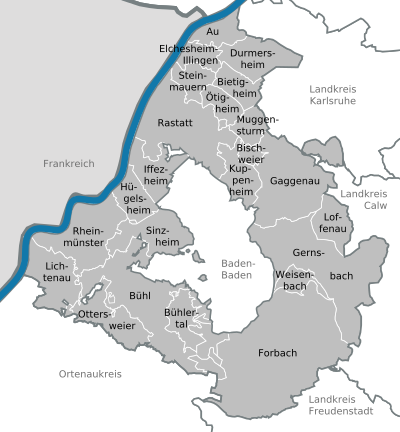
| Locations in the District RASTATT (Source: Wikipedia) |
||||||||||||


| The following Municipal Register contains all places of the "Geschichtlichen Orts-Verzeichnisses" (GOV) of CompGen in RASTATT. By activating the individual buttons in the four columns >Topo<, >SLUB<, >GOV< and >Meyers<, the geographical location of a place can be called up on a map from the geographical OpenTopoMap and Kartenforum or the place descriptions in the GOV-Ortsverzeichnis and Meyers Gazetteer. | ||||||||||||||||||||||||||
| A | B | C | D | E | F | G | H | I | J | K | L | M | N | O | P | Q | R | S | T | U | V | W | X | Y | Z | |
| Community | District | Location Type | GOV | Meyers | Parts of a Community | Type | Coordinates | Topo | WikiM | SLUB | GOV |
| Au am Rhein | Rastatt | Community |  |
 |
St. Andreas (Au a. Rh.) | Municipality | 48.9510 N 008.2397 E |  |
 |
 |
|
| Community | District | Location Type | GOV | Meyers | Parts of a Community | Type | Coordinates | Topo | WikiM | SLUB | GOV |
| Bietigheim | Rastatt | Community | |
|
Hl. Kreuz (Bietigheim) | Municipality | 48.9133 N 008.2489 E | |
|
|
|
| Bischweier | Rastatt | Community | |
|
St. Anna (Bischweier) | Municipality | 48.8378 N 008.2853 E | |
|
|
|
| Bühl | Rastatt | Town | |
|
St. Peter und Paul (Bühl) | City | 48.6956 N 008.1350 E | |
|
|
|
| St. Johannes der Täufer (Vimbuch) | City | 48.7184 N 008.1176 E | |
|
|
|
St. Gallus (Altschweier) | City | 48.6987 N 008.1612 E | |
|
|
|
St. Karl Borromäus (Bühl-Neusatz) | City | 48.6682 N 008.1506 E | |
|
|
|
St. Maria (Kappelwindeck) | City | 48.6916 N 008.1462 E | |
|
|
|
St. Dionys (Bühl-Moos) | City | 48.7183 N 008.0660 E | |
|
|
|
St. Matthäus (Bühl-Eisental) | City | 48.7123 N 008.1634 E | |
|
|
|
Hl. Blut (Bühl-Weitenung) | City | 48.7401 N 008.1279 E | |
|
|
|
| Bühlertal | Rastatt | Community | |
|
St. Michael (Bühlertal) | Municipality | 48.6946 N 008.1767 E | |
|
|
|
| Liebfrauen (Bühlertal) | Municipality | 48.6782 N 008.1931 E | |
|
|
|
|||||
| Community | District | Location Type | GOV | Meyers | Parts of a Community | Type | Coordinates | Topo | WikiM | SLUB | GOV |
| Durmersheim | Rastatt | Community | |
|
St. Dionysius (Durmersheim) | Municipality | 48.9310 N 008.2692 E | |
|
|
|
| Herz Jesu (Würmersheim) | Municipality | 48.9370 N 008.2523 E | |
|
|
|
St. Maria Bickesheim | Municipality | 48.9382 N 008.2727 E | |
|
|
|
| Community | District | Location Type | GOV | Meyers | Parts of a Community | Type | Coordinates | Topo | WikiM | SLUB | GOV |
| Elchesheim-Illingen | Rastatt | Community | |
|
Hl. Geist (Elchesheim-Illingen) | Municipality | 48.9299 N 008.2084 E | |
|
|
|
| Community | District | Location Type | GOV | Meyers | Parts of a Community | Type | Coordinates | Topo | WikiM | SLUB | GOV |
| Forbach | Rastatt | Community | |
|
St. Johannes (Forbach) | Municipality | 48.6806 N 008.3571 E | |
|
|
|
| St. Valentin (Langenbrand) | Municipality | 48.7031 N 008.3595 E | |
|
|
|
St. Antonius (Forbach-Herrenwies) | Municipality | 48.6607 N 008.2661 E | |
|
|
|
St. Antonius (Bermersbach) | Municipality | 48.6928 N 008.3444 E | |
|
|
|
Seliger Bernhard von Baden (Gausbach) | Municipality | 48.6837 N 008.3625 E | |
|
|
|
| Community | District | Location Type | GOV | Meyers | Parts of a Community | Type | Coordinates | Topo | WikiM | SLUB | GOV |
| Gaggenau | Rastatt | Town | |
|
St. Anna (Sulzbach) | City | 48.8071 N 008.3611 E | |
|
|
|
| Maria Hilf (Moosbronn) | City | 48.8370 N 008.3874 E | |
|
|
|
St. Jodokus (Ottenau) | City | 48.7922 N 008.3386 E | |
|
|
|
St. Johannes (Oberweier) | City | 48.8474 N 008.3091 E | |
|
|
|
St. Johannes Nepomuk (Hörden) | City | 48.7806 N 008.3465 E | |
|
|
|
St. Joseph (Gaggenau) | City | 48.8041 N 008.3198 E | |
|
|
|
St. Laurentius (Bad Rotenfels) | City | 48.8132 N 008.3045 E | |
|
|
|
St. Marien (Gaggenau) | City | 48.8033 N 008.3121 E | |
|
|
|
St. Nikolaus (Selbach) | City | 48.7805 N 008.3088 E | |
|
|
|
St. Michael (Michelbach) | City | 48.8185 N 008.3512 E | |
|
|
|
| Gernsbach | Rastatt | Town | |
|
St. Marien (Gernsbach) | City | 48.7635 N 008.3313 E | |
|
|
|
| Herz Jesu (Obertsrot) | City | 48.7427 N 008.3451 E | |
|
|
|
St. Mauritius (Reichental) | City | 48.7295 N 008.3893 E | |
|
|
|
| Community | District | Location Type | GOV | Meyers | Parts of a Community | Type | Coordinates | Topo | WikiM | SLUB | GOV |
| Hügelsheim | Rastatt | Community | |
|
St. Laurentius (Hügelsheim) | Municipality | 48.7974 N 008.1109 E | |
|
|
|
| Community | District | Location Type | GOV | Meyers | Parts of a Community | Type | Coordinates | Topo | WikiM | SLUB | GOV |
| Iffezheim | Rastatt | Community | |
|
St. Birgitta (Iffezheim) | Municipality | 48.8228 N 008.1415 E | |
|
|
|
| Community | District | Location Type | GOV | Meyers | Parts of a Community | Type | Coordinates | Topo | WikiM | SLUB | GOV |
| Kuppenheim | Rastatt | Town | |
|
St. Sebastian (Kuppenheim) | City | 48.8276 N 008.2549 E | |
|
|
|
| Community | District | Location Type | GOV | Meyers | Parts of a Community | Type | Coordinates | Topo | WikiM | SLUB | GOV |
| Loffenau | Rastatt | Community | |
|
Loffenau/Heilig-Kreuz | Municipality | 48.7744 N 008.3862 E | |
|
|
|
| Community | District | Location Type | GOV | Meyers | Parts of a Community | Type | Coordinates | Topo | WikiM | SLUB | GOV |
| Muggensturm | Rastatt | Community | |
|
Maria Königin der Engel (Muggensturm) | Municipality | 48.8683 N 008.2806 E | |
|
|
|
| Community | District | Location Type | GOV | Meyers | Parts of a Community | Type | Coordinates | Topo | WikiM | SLUB | GOV |
| Ötigheim | Rastatt | Community | |
|
St. Michael (Ötigheim) | Municipality | 48.8914 N 008.2324 E | |
|
|
|
| Ottersweier | Rastatt | Community | |
|
St. Johannes d. T. (Ottersweier) | Municipality | 48.6680 N 008.1113 E | |
|
|
|
| Maria Linden (Ottersweier) | Municipality | 48.6722 N 008.1199 E | |
|
|
|
|||||
| Community | District | Location Type | GOV | Meyers | Parts of a Community | Type | Coordinates | Topo | WikiM | SLUB | GOV |
| Rastatt | Rastatt | Town | |
|
St. Jakobus (Plittersdorf) | City | 48.8811 N 008.1574 E | |
|
|
|
| Zwölf Apostel (Rastatt) | City | 48.8676 N 008.2135 E | |
|
|
|
St. Michael (Wintersdorf) | City | 48.8474 N 008.1355 E | |
|
|
|
St. Ägidius (Ottersdorf) | City | 48.8609 N 008.1544 E | |
|
|
|
St. Laurentius (Niederbühl) | City | 48.8434 N 008.2176 E | |
|
|
|
St. Anna (Rauental) | City | 48.8571 N 008.2482 E | |
|
|
|
St. Alexander (Rastatt) | City | 48.8570 N 008.2032 E | |
|
|
|
Hl. Kreuz (Rastatt) | City | 48.8678 N 008.1931 E | |
|
|
|
Herz Jesu (Rastatt) | City | 48.8408 N 008.2011 E | |
|
|
|
| Rheinmünster | Rastatt | Community | |
|
St. Johannes und Paulus (Greffern) | Municipality | 48.7511 N 008.0052 E | |
|
|
|
| St. Peter und Paul (Schwarzach) | Municipality | 48.7459 N 008.0478 E | |
|
|
|
St. Mauritius (Söllingen) | Municipality | 48.7778 N 008.0604 E | |
|
|
|
Mariä Heimsuchung (Schiftung) | Municipality | |
St. Erhard (Stollhofen) | Municipality | 48.7626 N 008.0510 E | |
|
|
|
| Community | District | Location Type | GOV | Meyers | Parts of a Community | Type | Coordinates | Topo | WikiM | SLUB | GOV |
| Sinzheim | Rastatt | Community | |
|
St. Wendelin (Leiberstung) | Municipality | |
||||
| St. Martin (Sinzheim) | Municipality | 48.7614 N 008.1639 E | |
|
|
|
|||||
| Steinmauern | Rastatt | Community | |
|
Heilig Kreuz (Steinmauern) | Municipality | 48.9010 N 008.2008 E | |
|
|
|
| Community | District | Location Type | GOV | Meyers | Parts of a Community | Type | Coordinates | Topo | WikiM | SLUB | GOV |
| Weisenbach | Rastatt | Community | |
|
St. Wendelin (Weisenbach) | Municipality | 48.7291 N 008.3530 E | |
|
|
|
| Maria Königin (Au im Murgtal) | Municipality | 48.7195 N 008.3607 E | |
|
|
|
|||||
|
||||||||||