|
|||||||||||
| District ENZKREIS - Church Register - |
|||||||||||
|
|
|
||||||||||
| District ENZKREIS on the map of Germany (Source: Wikipedia) |
District ENZKREIS on the map of Baden-Wuerttemberg (Source: Wikipedia) |
|||||||||||
|
||||||||||||
|
||||||||||||
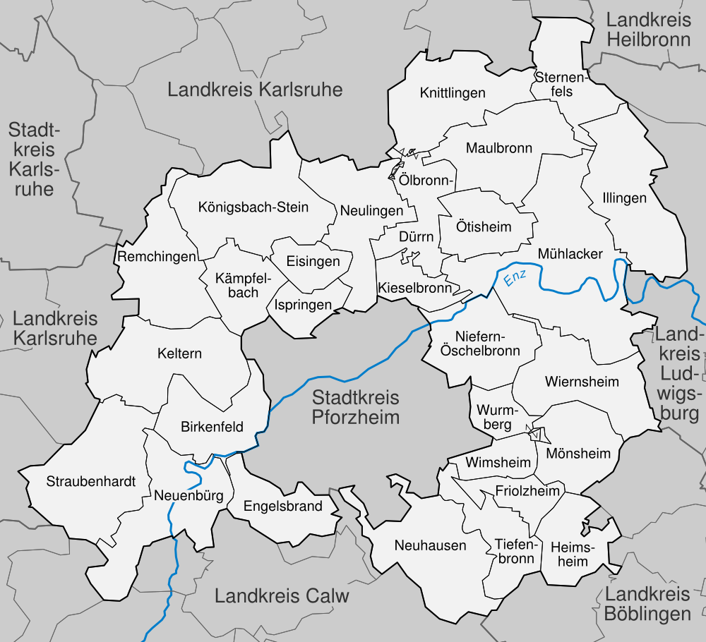
| Locations in the District ENZKREIS (Source: Wikipedia) |
||||||||||||


| The following Municipal Register contains all places of the "Geschichtlichen Orts-Verzeichnisses" (GOV) of CompGen in ENZKREIS. By activating the individual buttons in the four columns >Topo<, >SLUB<, >GOV< and >Meyers<, the geographical location of a place can be called up on a map from the geographical OpenTopoMap and Kartenforum or the place descriptions in the GOV-Ortsverzeichnis and Meyers Gazetteer. | ||||||||||||||||||||||||||
| A | B | C | D | E | F | G | H | I | J | K | L | M | N | O | P | Q | R | S | T | U | V | W | X | Y | Z | |
| Community | District | Location Type | GOV | Meyers | Parts of a Community | Type | Coordinates | Topo | WikiM | SLUB | GOV |
| Birkenfeld | Enzkreis | Community |  |
 |
Gr�fenhausen/Michael | Municipality | 48.8711 N 008.5816 E |  |
 |
 |
|
| Birkenfeld | Municipality | 48.8712 N 008.6369 E | |
|
|
|
|||||
| Community | District | Location Type | GOV | Meyers | Parts of a Community | Type | Coordinates | Topo | WikiM | SLUB | GOV |
| Engelsbrand | Enzkreis | Community | |
|
Engelsbrand/Antonius | Municipality | 48.8312 N 008.6449 E | |
|
|
|
| Grunbach/Nikolaus | Municipality | 48.8320 N 008.6752 E | |
|
|
|
Salmbach | Municipality | 48.8237 N 008.6582 E | |
|
|
|
| Community | District | Location Type | GOV | Meyers | Parts of a Community | Type | Coordinates | Topo | WikiM | SLUB | GOV |
| Friolzheim | Enzkreis | Community | |
|
Friolzheim | Municipality | |
| Community | District | Location Type | GOV | Meyers | Parts of a Community | Type | Coordinates | Topo | WikiM | SLUB | GOV |
| Heimsheim | Enzkreis | Town | |
|
Heimsheim (Heilig Geist) | City | 48.8029 N 008.8642 E | |
|
|
|
| Community | District | Location Type | GOV | Meyers | Parts of a Community | Type | Coordinates | Topo | WikiM | SLUB | GOV |
| Illingen | Enzkreis | Community | |
|
Illingen (St. Joseph) | Municipality | 48.9533 N 008.9281 E | |
|
|
|
| Ispringen | Enzkreis | Community | |
|
Maria K�nigin (Ispringen) | Municipality | 48.9130 N 008.6719 E | |
|
|
|
| Community | District | Location Type | GOV | Meyers | Parts of a Community | Type | Coordinates | Topo | WikiM | SLUB | GOV |
| K�mpfelbach | Enzkreis | Community | |
|
Christ K�nig (Ersingen) | Municipality | 48.9321 N 008.6347 E | |
|
|
|
| Hl. Dreieinigkeit (Bilfingen) | Municipality | 48.9482 N 008.6200 E | |
|
|
|
|||||
| Keltern | Enzkreis | Community | |
|
Andreaskirche Dietlingen | Municipality | 48.8954 N 008.6040 E | |
|
|
|
| Heilige Familie (Keltern-Dietlingen) | Municipality | 48.8954 N 008.6015 E | |
|
|
|
Niebelsbach/Pankratius | Municipality | 48.8820 N 008.5653 E | |
|
|
|
| Kieselbronn | Enzkreis | Community | |
|
Stephanus-Kirche/Kieselbronn | Municipality | 48.9362 N 008.7520 E | |
|
|
|
| K�nigsbach-Stein | Enzkreis | Community | |
|
Stein | Municipality | |
||||
| K�nigsbach | Municipality | |
|||||||||
| Community | District | Location Type | GOV | Meyers | Parts of a Community | Type | Coordinates | Topo | WikiM | SLUB | GOV |
| Neuenb�rg | Enzkreis | Town | |
|
Neuenb�rg/Georg | City | 48.8471 N 008.5902 E | |
|
|
|
| Neuenb�rg/Stadt | City | 48.8463 N 008.5890 E | |
|
|
|
Neuenb�rg (Heilig Kreuz) | City | 48.8459 N 008.5970 E | |
|
|
|
Waldrennach/Fels-Christus | City | 48.8334 N 008.6116 E | |
|
|
|
Dennach/Christus | City | 48.8226 N 008.5544 E | |
|
|
|
Arnbach/Luther | City | 48.8594 N 008.5699 E | |
|
|
|
| Neuhausen, Enzkreis | Enzkreis | Community | |
|
St. Nicolaus (Schellbronn) | Municipality | 48.8176 N 008.7417 E | |
|
|
|
| St. Wolfgang (Hamberg) | Municipality | 48.8207 N 008.7773 E | |
|
|
|
St. Urban und Vitus (Neuhausen) | Municipality | 48.7927 N 008.7797 E | |
|
|
|
| Neulingen | Enzkreis | Community | |
|
St. Stephan (Nu�baum) | Municipality | 48.9889 N 008.6929 E | |
|
|
|
| Niefern-�schelbronn | Enzkreis | Community | |
|
Liebfrauen (Niefern) | Municipality | 48.9145 N 008.7828 E | |
|
|
|
| Community | District | Location Type | GOV | Meyers | Parts of a Community | Type | Coordinates | Topo | WikiM | SLUB | GOV |
| �lbronn-D�rrn | Enzkreis | Community | |
|
St. Johannes (D�rrn) | Municipality | 48.9575 N 008.7571 E | |
|
|
|
| Community | District | Location Type | GOV | Meyers | Parts of a Community | Type | Coordinates | Topo | WikiM | SLUB | GOV |
| Remchingen | Enzkreis | Community | |
|
Singen | Municipality | |
||||
| N�ttingen | Municipality | |
Wilferdingen | Municipality | |
||||||
| Community | District | Location Type | GOV | Meyers | Parts of a Community | Type | Coordinates | Topo | WikiM | SLUB | GOV |
| Straubenhardt | Enzkreis | Community | |
|
Schwann/Schloss | Municipality | 48.8482 N 008.5518 E | |
|
|
|
| Ottenhausen/Nikolaus | Municipality | 48.8750 N 008.5397 E | |
|
|
|
Pfinzweiler/Auferstehung | Municipality | 48.8555 N 008.5146 E | |
|
|
|
Feldrennach/Stephan | Municipality | 48.8552 N 008.5332 E | |
|
|
|
Conweiler/Martin | Municipality | 48.8424 N 008.5313 E | |
|
|
|
| Community | District | Location Type | GOV | Meyers | Parts of a Community | Type | Coordinates | Topo | WikiM | SLUB | GOV |
| Tiefenbronn | Enzkreis | Community | |
|
St. Maria Magdalena (Tiefenbronn) | Municipality | 48.8238 N 008.8020 E | |
|
|
|
| M�hlhausen | Municipality | |
St. Alexander (M�hlhausen) | Municipality | 48.8042 N 008.8249 E | |
|
|
|
St. Ottilia (Lehningen) | Municipality | 48.7945 N 008.8179 E | |
|
|
|
| Community | District | Location Type | GOV | Meyers | Parts of a Community | Type | Coordinates | Topo | WikiM | SLUB | GOV |
| Wiernsheim | Enzkreis | Community | |
|
Wiernsheim (Heilig Kreuz) | Municipality | 48.8896 N 008.8524 E | |
|
|
|
| Wimsheim | Enzkreis | Community | |
|
Wimsheim | Municipality | |
|
||||||||||