|
|||||||||||
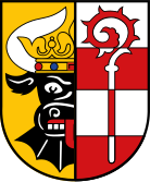
| Landkreis NORDWESTMECKLENBURG - Kirchenregister - |
|||||||||||
|
|
|
||||||||||
| Landkreis NORDWESTMECKLENBURG auf der Karte von Deutschland (Quelle: Wikipedia) |
Landkreis NORDWESTMECKLENBURG auf der Karte von MECKLENBURG-VORPOMMERN (Quelle: Wikipedia) |
|||||||||||
|
||||||||||||
|
||||||||||||
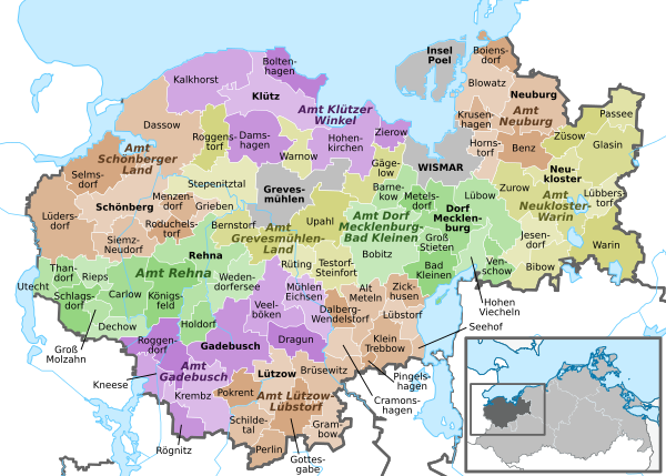
| Regionen im Landkreis NORDWESTMECKLENBURG (Quelle: Wikipedia) |
||||||||||||


| Das nachfolgende Kirchenregister enthält alle Orte des "Geschichtlichen Orts-Verzeichnisses" (GOV) von CompGen in NORDWESTMECKLENBURG. Durch Aktivierung der einzelnen Schaltflächen in den vier Spalten >Topo<, >SLUB<, >GOV< und >Meyers< sind die geografische Lage eines Ortes auf einer Karte von OpenTopoMap und Kartenforum oder die Ortbeschreibungen im GOV-Ortsverzeichnis oder Meyers Gazetteer aufrufbar. | ||||||||||||||||||||||||||
| A | B | C | D | E | F | G | H | I | J | K | L | M | N | O | P | Q | R | S | T | U | V | W | X | Y | Z | |
| Gemeinde | Landkreis | Ortstyp | GOV | Meyers | Ortsteile | Typ Ortsteil | Koordinate | Topo | WikiM | SLUB | GOV |
| Alt Meteln | Nordwestmecklenburg | Gemeinde |  |
 |
Alt-Meteln | Kirche | 53.7469 N 011.3403 E |  |
 |
 |
|
| Gemeinde | Landkreis | Ortstyp | GOV | Meyers | Ortsteile | Typ Ortsteil | Koordinate | Topo | WikiM | SLUB | GOV |
| Bad Kleinen | Nordwestmecklenburg | Gemeinde | |
|
Gemeindezentrum Arche/Bad Kleinen | Kirche | 53.7699 N 011.4733 E | |
|
|
|
| Beidendorf | Nordwestmecklenburg | Gemeinde | |
|
Dorfkirche/Beidendorf | Kirche | 53.8306 N 011.3868 E | |
|
|
|
| Benz | Nordwestmecklenburg | Gemeinde | |
|
Dorfkirche/Goldebee | Kirche | 53.8986 N 011.6143 E | |
|
|
|
| Bibow | Nordwestmecklenburg | Gemeinde | |
|
Dorfkirche/Bibow | Kirche | 53.7840 N 011.6423 E | |
|
|
|
| Blowatz | Nordwestmecklenburg | Gemeinde | |
|
Dorfkirche/Dreveskirchen | Kirche | 53.9939 N 011.5384 E | |
|
|
|
| Bobitz | Nordwestmecklenburg | Gemeinde | |
|
Dorfkirche St. Katharinen/Dambeck | Kirche | 53.7858 N 011.3721 E | |
|
|
|
| Boltenhagen | Nordwestmecklenburg | Gemeinde | |
|
Kirche zur Paulsh÷he/Boltenhagen | Kirche | 53.9884 N 011.2012 E | |
|
|
|
| Br³sewitz | Nordwestmecklenburg | Gemeinde | |
|
Dorfkirche/Gro▀ Br³tz | Kirche | 53.6502 N 011.2535 E | |
|
|
|
| Gemeinde | Landkreis | Ortstyp | GOV | Meyers | Ortsteile | Typ Ortsteil | Koordinate | Topo | WikiM | SLUB | GOV |
| Carlow | Nordwestmecklenburg | Gemeinde | |
|
Dorfkirche/Carlow | Kirche | 53.7586 N 010.9368 E | |
|
|
|
| Cramonshagen | Nordwestmecklenburg | Gemeinde | |
|
Dorfkirche/Cramon | Kirche | 53.7150 N 011.2788 E | |
|
|
|
| Gemeinde | Landkreis | Ortstyp | GOV | Meyers | Ortsteile | Typ Ortsteil | Koordinate | Topo | WikiM | SLUB | GOV |
| Damshagen | Nordwestmecklenburg | Gemeinde | |
|
Dorfkirche St. Thomas/Damshagen | Kirche | 53.9274 N 011.1528 E | |
|
|
|
| Dassow | Nordwestmecklenburg | Stadt | |
|
Nikolaikirche/Dassow | Kirche | 53.9076 N 010.9761 E | |
|
|
|
| Dorf Mecklenburg | Nordwestmecklenburg | Gemeinde | |
|
Ev. Kirche/Dorf Mecklenburg | Kirche | 53.8416 N 011.4692 E | |
|
|
|
| Dragun | Nordwestmecklenburg | Gemeinde | |
|
Dorfkirche/Vietl³bbe | Kirche | 53.7103 N 011.1991 E | |
|
|
|
| Gemeinde | Landkreis | Ortstyp | GOV | Meyers | Ortsteile | Typ Ortsteil | Koordinate | Topo | WikiM | SLUB | GOV |
| Gadebusch | Nordwestmecklenburg | Stadt | |
|
Stadtkirche St. Jakobus und St. Dionysius/Gadebusc | Kirche | 53.7022 N 011.1174 E | |
|
|
|
| Gõgelow | Nordwestmecklenburg | Gemeinde | |
|
Dorfkirche/Gressow | Kirche | 53.8640 N 011.3242 E | |
|
|
|
| Dorfkirche/Proseken | Kirche | 53.9040 N 011.3690 E | |
|
|
|
|||||
| Glasin | Nordwestmecklenburg | Gemeinde | |
|
Dorfkirche/Gro▀-Tessin | Kirche | 53.8968 N 011.7870 E | |
|
|
|
| Grevesm³hlen | Nordwestmecklenburg | Stadt | |
|
Grevesm³hlen (Sel. Niels Stensen) | Kirche | |
||||
| st. Mikolai-Kirche/Grevesm³hlen | Kirche | 53.8631 N 011.1843 E | |
|
|
|
|||||
| Gemeinde | Landkreis | Ortstyp | GOV | Meyers | Ortsteile | Typ Ortsteil | Koordinate | Topo | WikiM | SLUB | GOV |
| Hohen Viecheln | Nordwestmecklenburg | Gemeinde | |
|
Dorfkirche/Hohen-Viecheln | Kirche | 53.7844 N 011.5134 E | |
|
|
|
| Hohenkirchen | Nordwestmecklenburg | Gemeinde | |
|
Dorfkirche/Hohenkirchen | Kirche | 53.9191 N 011.3045 E | |
|
|
|
| Holdorf | Nordwestmecklenburg | Gemeinde | |
|
Ev. Kirche/Meetzen | Kirche | 53.7113 N 011.0467 E | |
|
|
|
| Hornstorf | Nordwestmecklenburg | Gemeinde | |
|
Dorfkirche St. Laurentius/Hornstorf | Kirche | 53.9090 N 011.5320 E | |
|
|
|
| Gemeinde | Landkreis | Ortstyp | GOV | Meyers | Ortsteile | Typ Ortsteil | Koordinate | Topo | WikiM | SLUB | GOV |
| Insel Poel | Nordwestmecklenburg | Gemeinde | |
|
Dorfkirche/Kirchdorf(Poel) | Kirche | 53.9944 N 011.4376 E | |
|
|
|
| Gemeinde | Landkreis | Ortstyp | GOV | Meyers | Ortsteile | Typ Ortsteil | Koordinate | Topo | WikiM | SLUB | GOV |
| Jesendorf | Nordwestmecklenburg | Gemeinde | |
|
Dorfkirche/Jesendorf | Kirche | 53.8025 N 011.5996 E | |
|
|
|
| Gemeinde | Landkreis | Ortstyp | GOV | Meyers | Ortsteile | Typ Ortsteil | Koordinate | Topo | WikiM | SLUB | GOV |
| Klein Trebbow | Nordwestmecklenburg | Gemeinde | |
|
Gro▀-Trebbow | Kirche | 53.7087 N 011.3598 E | |
|
|
|
| Kirch St³ck | Kirche | 53.6907 N 011.3964 E | |
|
|
|
|||||
| Kl³tz | Nordwestmecklenburg | Stadt | |
|
Kl³tz (Mariõ Aufnahme in den Himmel) | Kirche | |
||||
| St. Marienkirche/Kl³tz | Kirche | 53.9665 N 011.1659 E | |
|
|
|
|||||
| K÷nigsfeld | Nordwestmecklenburg | Gemeinde | |
|
Petrikirche/Demern | Kirche | 53.7417 N 010.9858 E | |
|
|
|
| Krembz | Nordwestmecklenburg | Gemeinde | |
|
St. Marienkirche/Gro▀-Salitz | Kirche | 53.6669 N 011.0475 E | |
|
|
|
| Gemeinde | Landkreis | Ortstyp | GOV | Meyers | Ortsteile | Typ Ortsteil | Koordinate | Topo | WikiM | SLUB | GOV |
| L³bow | Nordwestmecklenburg | Gemeinde | |
|
Dorfkirche/L³bow | Kirche | 53.8541 N 011.5231 E | |
|
|
|
| L³dersdorf | Nordwestmecklenburg | Gemeinde | |
|
Dorfkirche/Herrnburg | Kirche | 53.8341 N 010.7654 E | |
|
|
|
| Gemeinde | Landkreis | Ortstyp | GOV | Meyers | Ortsteile | Typ Ortsteil | Koordinate | Topo | WikiM | SLUB | GOV |
| M³hlen Eichsen | Nordwestmecklenburg | Gemeinde | |
|
Dorfkirche/M³hlen-Eichsen | Kirche | 53.7584 N 011.2518 E | |
|
|
|
| Johanniterkirche/Gro▀ Eichsen | Kirche | 53.7461 N 011.2603 E | |
|
|
|
|||||
| Gemeinde | Landkreis | Ortstyp | GOV | Meyers | Ortsteile | Typ Ortsteil | Koordinate | Topo | WikiM | SLUB | GOV |
| Neukloster | Nordwestmecklenburg | Stadt | |
|
Klosterkirche Sonnenkamp/Neukloster | Kirche | 53.8628 N 011.6862 E | |
|
|
|
| Gemeinde | Landkreis | Ortstyp | GOV | Meyers | Ortsteile | Typ Ortsteil | Koordinate | Topo | WikiM | SLUB | GOV |
| Passee | Nordwestmecklenburg | Gemeinde | |
|
Dorfkirche/Passee | Kirche | 53.9563 N 011.7696 E | |
|
|
|
| Perlin | Nordwestmecklenburg | Gemeinde | |
|
Dorfkirche/Perlin | Kirche | 53.5862 N 011.1718 E | |
|
|
|
| Pl³schow | Nordwestmecklenburg | Gemeinde | |
|
Dorfkirche/Friedrichshagen | Kirche | 53.8232 N 011.2817 E | |
|
|
|
| Pokrent | Nordwestmecklenburg | Gemeinde | |
|
Dorfkirche/Pokrent | Kirche | 53.6465 N 011.1422 E | |
|
|
|
| Gemeinde | Landkreis | Ortstyp | GOV | Meyers | Ortsteile | Typ Ortsteil | Koordinate | Topo | WikiM | SLUB | GOV |
| Rehna | Nordwestmecklenburg | Stadt | |
|
Rehna (Mariõ Namen/St. Ansverus) | Kirche | |
||||
| Klosterkirche/Rehna | Kirche | 53.7807 N 011.0505 E | |
|
|
|
|||||
| Roduchelstorf | Nordwestmecklenburg | Gemeinde | |
|
Dorfkirche/L³bsee (Menzendorf) | Kirche | 53.8330 N 011.0242 E | |
|
|
|
| Roggendorf | Nordwestmecklenburg | Gemeinde | |
|
Dorfkirche/Roggendorf | Kirche | 53.6932 N 011.0155 E | |
|
|
|
| Roggenstorf | Nordwestmecklenburg | Gemeinde | |
|
St. Johanneskirche/Roggenstorf | Kirche | 53.9137 N 011.0665 E | |
|
|
|
| R³ting | Nordwestmecklenburg | Gemeinde | |
|
Dorfkirche/Diedrichshagen | Kirche | 53.8048 N 011.2079 E | |
|
|
|
| Gemeinde | Landkreis | Ortstyp | GOV | Meyers | Ortsteile | Typ Ortsteil | Koordinate | Topo | WikiM | SLUB | GOV |
| Schildetal | Nordwestmecklenburg | Gemeinde | |
|
Dorfkirche/Badow | Kirche | 53.6118 N 011.1196 E | |
|
|
|
| Schlagsdorf | Nordwestmecklenburg | Gemeinde | |
|
Dorfkirche/Schlagsdorf | Kirche | 53.7303 N 010.8235 E | |
|
|
|
| Sch÷nberg(Mecklenburg) | Nordwestmecklenburg | Stadt | |
|
St. Laurentius-Kirche/Sch÷nberg | Kirche | 53.8450 N 010.9333 E | |
|
|
|
| Sch÷nberg (St. Maria Goretti) | Kirche | |
|||||||||
| Selmsdorf | Nordwestmecklenburg | Gemeinde | |
|
St. Marienkirche/Selmsdorf | Kirche | 53.8791 N 010.8629 E | |
|
|
|
| Stepenitztal | Nordwestmecklenburg | Gemeinde | |
|
Dorfkirche/B÷rzow | Kirche | 53.8573 N 011.1209 E | |
|
|
|
| Gemeinde | Landkreis | Ortstyp | GOV | Meyers | Ortsteile | Typ Ortsteil | Koordinate | Topo | WikiM | SLUB | GOV |
| Warin | Nordwestmecklenburg | Stadt | |
|
Stiftskirche/Warin | Kirche | 53.8023 N 011.7044 E | |
|
|
|
| Warnow | Nordwestmecklenburg | Gemeinde | |
|
Dorfkirche/B÷ssow | Kirche | 53.9185 N 011.2170 E | |
|
|
|
| Wedendorfersee | Nordwestmecklenburg | Gemeinde | |
|
Dorfkirche/Kirch Grambow | Kirche | 53.7690 N 011.1201 E | |
|
|
|
| Wismar | Nordwestmecklenburg | Stadt | |
|
St.Marien-Kirche/Wismar | Kirche | 53.8912 N 011.4629 E | |
|
|
|
| Neue Kirche/Wismar | Kirche | 53.8904 N 011.4637 E | |
|
|
|
Georgen-Kirche/Wismar | Kirche | 53.8908 N 011.4604 E | |
|
|
|
St.Nikolai-Kirche/Wismar | Kirche | 53.8955 N 011.4656 E | |
|
|
|
Heiligen Geist Kirche/Wismar | Kirche | 53.8920 N 011.4613 E | |
|
|
|
Wismar (St. Laurentius) | Kirche | |
| Gemeinde | Landkreis | Ortstyp | GOV | Meyers | Ortsteile | Typ Ortsteil | Koordinate | Topo | WikiM | SLUB | GOV |
| Zickhusen | Nordwestmecklenburg | Gemeinde | |
|
Zickhusen | Kirche | 53.7588 N 011.4104 E | |
|
|
|
| Zurow | Nordwestmecklenburg | Gemeinde | |
|
Dorfkirche/Zurow | Kirche | 53.8633 N 011.6151 E | |
|
|
|
| Z³sow | Nordwestmecklenburg | Gemeinde | |
|
Dorfkirche/Bõbelin | Kirche | 53.9329 N 011.7030 E | |
|
|
|
|
||||||||||